• 검색 결과가 없습니다.

Weighted Centroid Localization Algorithm Based on Mobile Anchor Node for Wireless Sensor Networks

N/A
N/A
Protected

Academic year: 2021

Share "Weighted Centroid Localization Algorithm Based on Mobile Anchor Node for Wireless Sensor Networks"

Copied!
6
0
0

로드 중.... (전체 텍스트 보기)

전체 글

(1)

Weighted Centroid Localization Algorithm Based on Mobile Anchor Node

for Wireless Sensor Networks

Jun-Ling Ma * Jung-Hyun Lee ** Kee-Wook Rim *** Seung-Jin Han ****

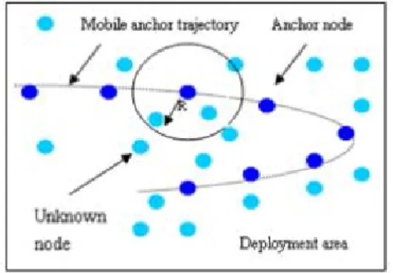
Abstract Localization of nodes is a key technology for application of wireless sensor network. Having a GPS receiver on every sensor node is costly. In the past, several approaches, including range-based and range-free, have been proposed to calculate positions for randomly deployed sensor nodes. Most of them use some special nodes, called anchor nodes, which are assumed to know their own locations. Other sensors compute their locations based on the information provided by these anchor nodes. This paper uses a single mobile anchor node to move in the sensing field and broadcast its current position periodically.

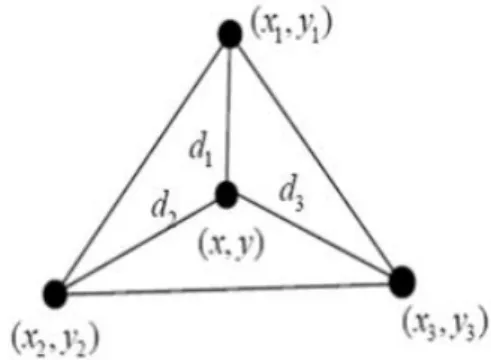
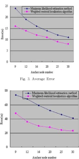
We provide a weighted centroid localization algorithm that uses coefficients, which are decided by the influence of mobile anchor node to unknown nodes, to prompt localization accuracy. We also suggest a criterion which is used to select mobile anchor node which involve in computing the position of nodes for improving localization accuracy. Weighted centroid localization algorithm is simple, and no communication is needed while locating. The localization accuracy of weighted centroid localization algorithm is better than maximum likelihood estimation which is used very often. It can be applied to many applications.

Keywords : Wireless Sensor Networks, Localization, Mobile Anchor Node, Centroid Algorithm

󰠕

This research was supported by the MKE(Ministry of Knowledge Economy), Korea, under the ITRC(Information Technology Research Center) Support program supervised by the IITA(Institute of Information Technology Advancement) (IITA-2009-C1090-0902-0020)

****

Master Student, Computer Information Engineering, Inha University, [email protected](corresponding author)

****

Professor, Division of Computer Science and Engineering, Inha University, [email protected]

****

Professor, Division of Computer Science and Engineering, Sunmoon University, [email protected]

****

Professor, School of Information and Media in Kyungin Women's College, [email protected] Manuscript received:2009.05.12 Revised:2009.06.16 Accepted:2009.06.20

1. Introduction

A sensor network is composed of a large number of sensor nodes that are densely deployed in a field. Each sensor performs a sensing task for detecting specific events. The sink, which is a particular node, is re- sponsible for collecting sensing data reported from all the sensors, and finally transmits the data to a task manager. If the sensors can not directly communicate with the sink, some intermediate sensors have to for- ward the data [1].

There are several essential issues(e.g., localization, deployment, and coverage) in wireless sensor net- works. Localization is one of the most important sub- jects for wireless sensor networks since many appli- cations such as environment monitoring, vehicle tracking and mapping depend on knowing the loca- tions of the sensor nodes [2]. In addition, with loca-

tion-based routing protocols [3], both routing and data forwarding are determined based on the geographic location.

To solve the localization problem, it is natural to consider placing sensors manually or equipping each sensor with a GPS receiver. However, due to the large scale nature of sensor networks, those two methods become either inefficient or costly, so researchers pro- pose to use a variety of localization approaches for sensor network localization.

These approaches can be classified as range-based and range-free. Firstly, the range-based approach uses an absolute node-to-node distance or angle between neighboring sensors to estimate locations.

Common techniques for distance or angle estimation

include received signal strength indicator(RSSI), time

of arrival(TOA), time difference of arrival(TDOA),

and angle of arrival(AOA). The approaches typically

(2)

have higher location accuracy but require additional hardware to measure distances or angles. Secondly, the range-free approach does not need the distance or angle information for localization, and depends only on connectivity of the network and the contents of re- ceived messages. For example, Centroid method[4], APIT method[5], DV-HOP method[6], Convex hull[7], Bounding box[8] , and Amorphous algorithm[9] have been proposed. Although the range-free approach can- not accomplish as high precision as the range- based [10], they provide an economic approach. Due to the inherent characteristics(low power and cost) of wire- less sensor networks, the range-free mechanism could be a better choice to localize a sensor’s position, so we pay more attention to range-free approach in this paper.

This paper uses a single mobile anchor node as the reference node, which is required to move in the sens- ing field and broadcast its current position periodically. Sensor nodes receive the position in- formation of the mobile node and localize themselves to the centroid of these positions by using the weight- ed centroid algorithm. The algorithm based on the Received Signal Strength Indication(RSSI). The re- sults of simulations show that the method is a prac- tical method that can be used in real-world system, and is also a method whose principle is simple, less computing and communication, is low cost, and pro- vides flexible accuracy.

2. Related Work

In the past several years, extensive research has been done on localization for wireless sensor networks. A general survey is found in. Here we pro- vide only a brief survey about range-free approaches and localization method, which involve mobile refer- ence nodes.

In a sensor network, some nodes are equipped with special positioning devices that are aware of their locations. These nodes are called anchor nodes or ref- erence nodes. Other nodes that do not initially know their locations are called unknown nodes or sensor nodes. Generally, an unknown node can estimate its location by range-based or range-free methods if three or more anchors are available in its coverage field. Obviously, the number and position of anchor nodes have a noticeable influence on the localization precision. Researchers showed that the precision of the localization increases with the increasing of the anchors' number. The main problem with an increased

number of anchors is that they are far more expensive than the rest of the sensors, even if only 10% of the nodes are anchors; the price of the whole network will increase about tenfold. Another observation is that af- ter the(stationary) unknown nodes have been localized, the anchors become useless. The reasoning mentioned above leads us to consider using a single mobile an- chor to localize the sensor network.

The main idea of localization with a mobile anchor node is as follows: After sensor deployment, a mobile anchor node traverses the sensor network while broadcasting anchor packets, which contain the coor- dinates of the anchor node. Sensor nodes receiving anchor packets could infer their distance from a mo- bile anchor node and use these measurements as con- straints to construct and maintain position estimates.

These methods have a common feature: they use range-based approaches. Though they can reach fine resolution, either the required hardware is ex- pensive(ultrasound devices for TDOA, antenna arrays for AOA) [11] or the results depend on other un- realistic assumptions about signal propagation(for ex- ample, the actual received signal strengths of radio signals can vary when the surrounding environment changes).

Due to the hardware limitations of sensor devices, range-free approaches are a cost effective alternative to a more expensive range-based approach. A simple algorithm proposed, computes location as the centroid of its proximate anchor nodes. An alternate solution, DV-Hop, extends the single hop broadcast to multi- ple-hop flooding, so that sensors can find their dis- tance from the anchors in terms of hop counts. An amorphous positioning scheme adopts a similar strat- egy as DV-Hop; the major difference is that Amorphous improves location estimates using offline hop-distance estimations through neighbor information exchange. Another existing range-free scheme is an APIT algorithm. APIT [12-13] resolves the local- ization problem by isolating the environment into tri- angular regions between anchor nodes. A node uses the point-in-triangle test to determine its relative lo- cation with triangles formed by anchors and thus nar- rows down the area in which it probably resides.

APIT defines the center of gravity of the intersection

of all triangles that a node resides in as the estimated

node location. [14-17]Based on these analyses, local-

ization using a single mobile anchor node would be

more economical. In addition, considering the con-

straints in computing and memory power of sensors,

we adopted the weighted centroid method with a sin-

(3)

gle mobile anchor to locate sensors in wireless sensor networks.

3. Method of Localization

This method can be used in large-scale field environment. Figure 1 illustrates the system environ- ment where a sensor network consists of a mobile an- chor node and unknown nodes that could be scattered from a plane or from a mortar shell. The mobile an- chor is a human operator or an unmanned vehicle de- ployed with the sensor network. If the network is de- ployed by plane scattering, this anchor can be even the plane itself. The unknown nodes are the nodes of initially unknown positions. Once the nodes are de- ployed, they will stay at their locations to conduct the sensing task. The mobile anchor, which is a node aware of its location(e.g. equipped with GPS), and is able to traverse for assisting the sensors to determine other node locations.[18-21] The mobile anchor node needs to traverse over the entire region in order to cover all sensor nodes. This can be done by driving the mobile anchor node to move in a spiral trajectory.

Obviously there are many other options to moving trajectory. Finding an optimal trajectory to cover all sensor nodes can be a research topic for our future work. No matter which trajectory is used, the location of the mobile anchor node on the trajectory should be known. At the same time, we assume that the mobile anchor has sufficient energy for moving and broad- casting its information during the localization process.

The speed of the mobile anchor is adjustable and un- restricted, but uniform in the process of location.

We used an idealized radio model for wireless com- munication because it was simple and easy to reason mathematically. We assumed that our idealized model is perfect spherical radio propagation and has identical transmission range(power) for all radio positions as shown in Figure 1. It is a sphere with the anchor as its center and the broadcasting radius R as its radius.

Only the sensors within the range are assumed capa- ble of receiving the information sent by the anchor.

In this paper, we proposed the location of mobile anchor node influence: In the localization algorithm, location of mobile anchor node has influence to the unknown nodes, RSSI bigger location, and the greater influence on the location of sensor nodes. When Unknown node received multiple mobile anchor node position signal Then unknown node by the impact of these locations. Location of largest RSSI has the

Fig. 1. System Environment with a Mobile Anchor Node

greatest power to decide to the position of sensor node.

Signal selection principle: An unknown node may receive multiple signals of positions from the mobile anchor node.

RSSI value should be the largest of several signals position calculation. Location computed to ensure that the signals involved in more than three. Will be dis- tances of more than R the location of mobile anchor node removed, so as to avoid the expansion of the po- sitioning error. Behind the simulation proves this point.

4. Weighted Centroid Localization Algorithm

Through the front of the Analysis, can find common centroid algorithm, did not reflect the mobile anchor node's influence, affecting the localization accuracy.

To enhance the localization accuracy, in this paper we used the weighted centroid localization algorithm. Its main idea: In the algorithm, mobile anchor node con- fronts the right to decide the location of the centroid through weighted factor to reflect. The use of weight- ed factor reflected the intrinsic relationship between them.

We embody this relationship through the formula of the weighted factor:

   



 



 



 

 

 

   



 



 



 

 

 

Figure 2 illustrates Known 3 mobile anchor nodes

coordinate (X

1

, Y

1

), (X

2

, Y

2

), (X

3

, Y

3

), unknown node

to anchor nodes distance d

1

, d

2

, d

3

. According to the

formula can be calculated unknown node coor-

(4)

dinates(X, Y). Compared to ordinary centroid algo- rithm, 1/d

1

, 1/d

2

, 1/d

3

is weighted factor. The factor 1/d

1

, 1/d

2

, 1/d

3

indicates that mobile anchor node with a shorter distance to unknown nodes has a larger in- fect its coordinates. We can improve the localization accuracy from these inner relations.

Fig. 2. Weighted Centroid Localization Algorithm

Weighted centroid localization algorithm process:

(1) The mobile anchor node periodically sends its own information.

(2) Unknown node received information, only re- cords the same location of the mobile anchor node average RSSI.

(3) Unknown node received over threshold m in the position information then RSSI value in accord- ance with the smallest sort of mobile anchor node location .And to establish the mapping be- tween RSSI value and the distance from un- known node to the mobile anchor node. The es- tablishment of three sets: mobile anchor node_set={a

1

, a

2

, …,a

m

} ; Distance_set={d

1

, d

2

,

…, d

m

} d

1

<d

2

….<d

m

; Mobile anchor node position_set={(X

1

, Y

1

), (X

2

, Y

2

), …, (X

m

, Y

m

)};

(4) RSSI value with the first few large location of mobile anchor node of the calculation:

Based on the preceding analysis, in the mobile an- chor node_set Select RSSI value of large node lo- cation then the composition of the triangle set.

This is very important. Triangle_set={(a

1

, a

2

,a

3

), (a

1

,a

2

, a

4

), …(a

1

,a

3

, a

4

), (a

1

,a

3

, a

5

) … };

(5) n location of mobile anchor nodes can be com- posed of 



triangles. The use formula(1) cal- culates 



coordinate.

(6) Calculates the mean value(X,Y) of



coor- dinate. The(X, Y) is Unknown node coordinate.

5. Simulation

The key metric for evaluating a localization techni- que is the accuracy of the location estimates versus the communication and deployment cost. Increasing the density of anchors or the frequency of location broadcasting should improve accuracy, but a tradeoff needs to be made to determine appropriate deployment parameters. To evaluate this proposed method we use UNIX, programs with the C language. We have car- ried on the computer simulation to the above algorithm. Simulation condition: The mobile anchor node reference MICA2 mote; Uses outdoor launches the radius 200 to 300m; Deployment area is 200*200㎡

.The unknown node arranges stochastically; the un- known node is 220. The mobile anchor node has 6 kinds of situations: 9, 12, 16, 20, 25, and 30 positions.

The simulation uses weighted centroid localization al- gorithm and maximum likelihood estimation method.

Localization accuracy mainly depends on the numbers of the mobile anchor node broadcasting its positions or the anchor density. It is very easy for our method to change anchor density by adjusting the interval time or the moving length of the mobile anchor node broadcasting its positions or by changing the moving interval of spiral line. In comparison with other meth- ods, this is one of the advantages with our method, and it does not require additional hardware. Figure 3 and Figure 4 show the simulation result. In the figure 3 error of weighted centroid localization algorithm is 16.2m and error of maximum likelihood estimation is 24.2m when mobile anchor node is 9. Error of weight- ed centroid localization algorithm is 14.4m and error of maximum likelihood estimation is 18.9m when mobile anchor node is 12. In the figure 4 error of weighted centroid localization algorithm is 48m and error of maximum likelihood estimation is 73m when mobile anchor node is 9. Error of weighted centroid local- ization algorithm is 38m and error of maximum like- lihood estimation is 67m when mobile anchor node is 12. .As can be seen from the figure weighted centroid localization algorithm has better localization accuracy.

Has the obvious superiority, if the anchor density is

low. Weighted centroid localization algorithm is sim-

ple, and no communication is needed while locating. It

does not require additional hardware. The mobile an-

chor node can be used many times. So it is very

inexpensive.

(5)

Fig. 3. Average Error

Fig. 4. Maximum Error 6. Conclusion and Future Works

Many wireless sensor network applications depend on nodes being able to accurately determine their locations. This is the first work to study range-free localization in the presence of mobility. One of our ideas is that a mobile anchor can improve the local- ization accuracy and coverage because it can move to every point of wireless sensor networks. Another fac- tor is that range-free requires no extra hardware or data communication and reduces the costs of localization. Our simulation experiments reveal that our method can provide accurate localization even when memory limits are severe, the seed density is low, and network transmissions are highly irregular.

Many issues remain to be explored in future work including how to select a moving path to improve the

locating performance, how to apply this to real-world sensor networks and how to expend our method to other applications.

References

[ 1 ] K.F. Ssu, C.H. Ou, and H. C. Jiau “Localization with mobile anchor points in wireless sensor networks.” IEEE Trans. on Vehicular Tech- nology, Vol.54 No.3, 2005, pp. 1187-1197.

[ 2 ] L. Hu and D. Evans “Localization for mobile sensor networks.” in Proc. of ACM MobiCom, 2004.

[ 3 ] Y. Ko and N. H. Vaidya “Location aided routing in mobile ad hoc networks.” in Proc. ACM Int.

Conf. Mobile Computing and Networking (MOBICOM), Dallas, TX, 1998, pp. 66-75.

[ 4 ] N. Bulusu, J. Heidemann, and D. Estrin

“GPS-less low cost outdoor localization for very small devices.” IEEE Personal Commun, vol. 7, 2000, pp. 28-34.

[ 5 ] T. He, C. Huang, B. M. Blum, J. A. Stankovic, and T. Abdelzaher “Range-free localization schemes for large scale sensor networks.” in Proc. ACM Int. Conf. Mobile Computing Networking(MOBICOM), San Diego, CA, 2003, pp. 81-95.

[ 6 ] D. Niculescu and B. Nath “DV based positioning in ad hoc networks.” Kluwer J. Telecommun.

Syst, vol. 22 No. 1, 2003, pp. 267-280.

[ 7 ] L. Doherty, L. E. Ghaoui and K. S. J. Pister

“Convex position estimation in wireless sensor networks.” In Proceedings of the IEEE INFOCOM ‘01, Anchorage, AK, 2001.

[ 8 ] S. Simic and S. Sastry “Distributed localization in wireless ad hoc networks.” Memorandum No.

UCB/ERL M02/26, University of Califormia, Berkeley, 2002.

[ 9 ] R. Nagpal, H. Shrobe, and J. Bachrach “Orga- nizing a global coordinate system from local information on an ad hoc sensor network.” In IPSN’03, 2003.

[10] Niculescu D, Nath B. “DV based positioning in ad hoc networks.” Journal of Telecommunication Systems, Vol.22 No4, 2003, pp. 267-280.

[11] Doherty L, Pister KSJ, Ghaoui LE. “Convex position estimation in wireless sensor networks.”

In: Proc. of the IEEE INFOCOM 2001.

Anchorage: IEEE Computer and Communications Societies, Vol. l No.3, 2001, pp. 1655-1663.

[12] Theodore S Rappaport, “Principles and Practice.

(6)

Prentice Hall PTR” Wireless Communications, 1996.

[13] Bahl P, Padmanabhan VN. RADAR, “An in- building RF-based user location and tracking system.” In: Proc. of the IEEE INFOCOM 2000, Tel Aviv: IEEE Computer and Communications Societies, Vol.2, 2000, pp. 775-784.

[14] Youngchang Kim, Youngjin Kim, Jaewoo Chang,

“Distributed Grid Scheme using S-GRID for Location Information Management of a Large Number of Moving Objects.” Journal of Korea Spatial Information System Society, Vol.10, No.4, 2008, pp. 143-813.

[15] Yang Koo Lee, Keun Ho Ryu, “Historical Sensor Data Management using Temporal Information,”

Journal of Korea Spatial Information System Society, Vol.10, No.4, 2008.

[16] Dong Bin Shin, Dong Bin Shin, “A Study on the Application of As-Built Drawings for Updating Digital Maps," Journal of Korea Spatial Information System Society, Vol.10, No.4, 2008.

[17] M. A. Hammad, W. G. Aref, A. K. Elmagarmid,

“Stream window join: Tracking moving objects in sensornetwork databases,” In SSDBM, 2003.

[18] Drago Niculescu and B. Nath, “Position and orientation in ad hoc networks.” Ad hoc Networks, Vol.2 No.2, 2002, pp. 133-151.

[19] M. Sullivan, A. Heybey, “Tribeca: A System for Managing Large Databases of Network Traffic,”

In Proc. of USENIX Annual Technical, 1998.

[20] G. R. Hjaltason, H. Samet, “Improved bulk- loading algorithms for quadtrees” In Pro- ceedings of the 7th ACM International Sym- posium on Advances in Geographic Information Systems, pp. 110-115.

[21] M.-L. LO, C. V. Ravishankar, “Spatial joins using seeded trees,” In Proceedings of the ACM SIGMOD Conference, pp. 209-220.

Jun-Ling Ma

2008 Dept. of Computer Engineering, HanSeo University(B.S.)

2008~Present Master Student, Dept. of Computer Information Engineering, Inha University

Research Interests : Wireless Sensor Networks, GIS

Jung-Hyun Lee

1977 Dept. of Electronics Engineering, Inha University(B.S.)

1980 Dept. of Computer Science, Inha University(M.S.)

1988 Dept. of Computer Science, Inha University(Ph.D.)

1979~1981 Researcher, ETRI

1984~1989 Professor, Division of Electronic Engineering, Kyonggi University

1989~Present Professor, Division of Computer Science and Engineering, Inha University

Research Interests : Natural Language, HCI, Speech Recongnition, Data Mining, Advanced Computer Architecture

Kee-Wook Rim

1977 Dept. of Computer Science, Inha University(B.S.)

1987 Dept. of Electronic Engineering, Hanyang University(M.S.)

1994 Dept. of Computer Science, Inha University(Ph.D.)

1977~1999 Senior Researcher at ETRI and TICOM Development Manager

2000~Present Professor, Division of Computer Science and Engineering, Sunmoon University

Research Interests : Real-time Database Systems, Operating Systems and System

Seung-jin Han

1990 Dept. of Computer Science, Inha University(B.S.)

1992 Dept. of Computer Science and Engineering, Inha University(M.S.) 2002 Dept. of Computer Science and Engineering, Inha University(Ph. D.) 2004~Present Professor, School of Information and Media in Kyungin Women's College

Research Interests :Wireless Sensor Networks, Security

수치

Fig.  1.  System  Environment  with  a        Mobile  Anchor  Node
Fig.  2.  Weighted  Centroid  Localization  Algorithm
Fig.  4.  Maximum  Error 6. Conclusion and Future Works

참조

관련 문서

 Part E: Numerical methods provide the transition from the mathematical model to an algorithm, which is a detailed stepwise recipe for solving a problem of the indicated kind

à Element nodes have child nodes, which can be attributes or subelements à Text in an element is modeled as a text node child of the element. à Children of a node

Moreover, based on the fact that nuclear localization of FoxO1 is regulated by SIRT1 deacetylase, we were further interested in whether a potent SIRT1 inhibitor, Amurensin

 Rule #1: Express currents in terms of node voltages: Count the number of unknown node voltages and the required number of KCL equations to solve..  Rule #2: If a node

§ Phase each signal to make sure the signals arrive “in phase” at the receiver (Phase shift is calculated by receiver and fed back to the

3.4 The estimating stage of relative coordinates : (d) coordinates transfer based on estimated reference node (e) Get the azimuth of mobile node (f) Get.. the final

In this paper, we propose tree-based greedy algorithm to solve the minimum power broadcasting problem for minimizing the total transmit power on broadcasting in wireless

Radiolocation Radiolocation Amateur-satelliteAmateur Radiolocation RADIOLOCATION RADIOLOCATION FIXEDEARTH EXPLORATION-SATELLITE (passive)SPACE RESEARCH