*종신회원, 국립목포해양대학교 항해정보시스템학부 접수일자: 2016년 8월 17일, 수정완료: 2016년 11월 5일 게재확정일자: 2016년 12월 9일
Received: 17 August, 2016 / Revised: 5 November, 2016 Accepted: 9 December, 2016
*Corresponding Author: [email protected]
Div. of Electric and Communication Eng. Mokpo National Maritime University, Korea
https://doi.org/10.7236/JIIBC.2016.16.6.119
JIIBC 2016-6-14
스마트폰을 이용한 소형 선박용 모션 감지 기능
Function of Motion Detection for Small-Size Vessel using Smart Phone
박천관
*Chun-Kwan Park
*요 약 연안에는 많은 배들이 운항을 하고 있어 사고의 위험에 노출되어 있다. 특히 안전 장비를 구비하지 않은 소형 선박은 다양한 원인에 의한 선박 상태에 따른 사고, 그리고 주변 선박 및 물체와의 충돌과 같은 해양사고에 무방비 상 태에 놓여있다. 따라서 이와 같은 상황을 저렴한 장비를 통하여 해결하는 것이 필요하다. 이를 위하여 본 논문에서는 스마트폰을 이용하여 선박 자체 움직임을 감지할 수 있는 기능을 구현하였다. 움직임이 정해진 임계값을 넘어선 경우, 이 기능은 현재 상황이 이 선박에 위험하다고 판단하고, 이 상황을 선박에 있는 스마프폰 소유자 및 제어 센터로 이 상황을 알린다. 이를 통하여 안전 장비가 거의 장착되어 있지 않은 어선, 여객선, 그리고 레저선박과 같은 소형 선박에 적용되어 선박의 안전 항해를 향상시킬 수 있다.
Abstract
In the coastal area, many kind of vessels are operating and exposed to the various marine accidents. In particular, small-size vessels, which are not equipped with the safety equipment, are in the defenceless state to the marine accidents such as the accident according to vessel’s own state caused by the diverse reasons and the collision with the neighborhood vessels and objectives. So it is necessary to resolve these situations through the inexpensive equipment. This paper implements the function that can detect vessel’s own motion using Smart Phone.if the motion is over the threshold value assigned, this function decides that the current situation is dangerous for this vessel. So this function informs Smart Phone’s ower in the vessel and the control center of this situation. This function can be applied to small-size vessels, such as fishing boating, passenger ship, and leasure boat, which have few the safety equipments, and then improve vessel’s safety navigation.
Key Words :
Vessel, Safety, Marine, Vessel, GMDSSⅠ. Introduction
These days there are a growing vessel volume in the costal area because there are diverse kind of actives in this area, such as fishing, tourism, leasure, sporting, and so on. So for this situation, there are the
various vessel accidents, such as stranding, sinking, collision, and so on
[1][2].
Vessels are classified into various scale, such as
small, medium, and large one. there are the safety
equipments to some extent in medium and large scale
vessels, but there are few safety equipments in small
scale vessels.
Vessels vulnerable to the ocean accidents, such as fishing boating, passenger ship, and leasure boat, are not nearly equipped with the safety equipments. So it is necessary for these vessels to have the equipments that can inform the control center and the surrounding vessels of the accidents
[2][3].
After Titanic’s sink in 1912, the necessary for the ocean safety was appeared in the world. So the international society started to discuss how to deal with this problem. After the Sewol Ferry tragedy in April 2014 in Korea, people recognized the importance of the ocean safety. The various navigational devices and the wireless communication equipments for both safe navigation and disaster prevention are being installed mandatorily. But there are few safety equipments in small size vessels because its cost is expensive or vessel’s owners do not recognize the importance of these equipments
[3].
In this paper, the function of safe navigation in small scale vessels is implemented. This function can detect the vessel’s motion through Smart Phone. if its motion is over the threshold level, it informs the vessel’s sailors and the control center of this situation through Smart Phone. So this function can provide the safety function to the small scale vessels that have not any safety equipments.
Ⅱ. Marine Communication Network
The prevention of the diverse ocean accidents and the fast countermeasure is indispensible in the several sides, such as the human life safety, the vessel safety, and the ocean environmental prevention. The small scale vessels have more dangerous elements than medium and large scale vessels when they are exposed to the ocean environment. So the technologies to support the safety navigation for small scale vessels have to be developed for the safety ocean activities in the costal area. In particular, the ocean accidents
caused by overthrow and stranding have been attributed to the hull itself, sailing not considering the weather condition, and the drastic changes in the weather during sailing
[3][4].
GMDSS(Global Maritime Distress and Safety System) is the advanced marine communication system to prevent the shipwreck accident and support the accurate research and rescue. its purpose is to install the shipwreck warning system which can transmit its situation to the neighborhood vessels and the relief agency when the shipwreck accident is occurred. Also it plans the safety sailing by receiving the various marine safety information transmitted from the marine safety agencies automatically
[4][5].
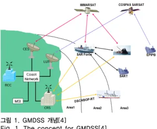
Figure 1 shows GMDSS concept. GMDSS classifies the world’s sea into four sea areas, and then proposes the frequency and the necessary functions for each sea area.
Area 1 is within 50~100km(20~30 nautical miles) from land and uses VHF wireless equipment. Area 2 is midium distance and the ocean region of 200~400km (100~120 nautical miles) from land and uses the wireless equipments using MF frequency band.
그림 1. GMDSS 개념[4]
Fig. 1. The concept for GMDSS[4]
Area 3 is defined as the long distance and covers
from the north latitude
to the south latitude
and uses the satellite Immarsat for ocean
communication or the communication equipments for
HF frequency band except Area 1/Area 2. Area 4 is the communication coverage of polar region except Area 1/Area 2/Area 4 and uses the communication equipments for HF frequency band
[4][5].
Almost all vessels are distributed over Area 1 and Area 2 classified by GMDSS. When considering all vessels including small-scale ones, 80 per cent of all vessels are distributed over Area 1.
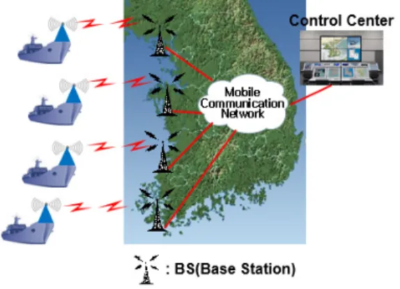
Figure 2 shows the network example for safety management system. Vessels are connected to the mobile communication network through the base station. The control center is connected to vessels through the mobile communication network. The ship safety monitoring device collects the status information for vessel and then transmits its information to the control center and the terminals in vessel such as SmartPhone and the dedicated terminals. And the system reports its own location, speed and direction to the control center through the base station periodically.
그림 2. 선박안전관리를 위한 네트워크
Fig. 2. Network for ship safety management
Ⅲ. Operation for detecting motion in Smartphone
Most smartphone has many kind of sensors including GPS (Global positioning system) function. In this paper, two sensors are used to detect vessel’s motion. These sensors are Gyro and three axis accelerometer. Figure 3 shows the motion of
smartphone placed on vessel.
그림 3. 스마트폰에서 모션 감지 동작
Fig. 3. Motion detection action in SmartPhone
Gyro sensor is used to detect the safety status of vessel. Pitch, Roll, and Yaw value can be detected from Gyro sensor. Three axis accelerometer is used to detect the collision and shock of vessel. X, Y, and Z value can be detected from Three axis accelerometer. Figure 4 show vessel’s motion detection operation flow. In this figure, A1/A2/A3 is pitch/roll/yaw for Gyro sensor and X/Y/Z axis for three axis accelerometer.
Fig. 4. Vessel’s motion detection operation 그림 4. 선박 모션 감지 동작
For two sensors, in the case of issuing the alarm
signal, the smart phone send this signal to the
dedicated terminals and the control center. If the alarm
signal sustains longer than the assigned time, this
smartphone decides that this is dangerous status and
then informs neighbor vessels of this situation.
Ⅳ. Implementation of motion detection function for small-scale vessel
This function receives the moving information of vessel from Gyro sensor and Three axis accelerometer, and decides the safety status of vessel, and then can issue the warning and alarm signals for vessel’s safety.
If this function detects the safety hazard symptom, it issues the warning signal. If this function detects the severe safety hazard problem, it issues the alarm signal.
Figure 5 shows the function to detect the safety status of vessel based on SmartPhone. this function includes vessel’s own location and speed, and then roll, pitch value and shock level.
Fig. 5. Monitor ship status in Smart Phone 그림 5. 스마트폰에서 선박 상태 모니터
Figure 6 shows the values related to three axis accelerometer at the vessel safety management system in the control center. This widow shows the variable value of X, Y, and Z axis caused by shock or collision.
Figure 7 shows the values related to Gyro sensor at the vessel safety management system in the control center. This widow shows the variable value of pitch, roll, and yaw in vessel. If the control center receive X/Y/Z axis and pitch/roll/yaw values from vessels in the costal areas. it takes proper measures according to the situation received from vessels.
Fig. 6. Monitoring X/Y/Z axis in server 그림 6. 서버에서 X/Y/Z 축 모니터링
Fig. 7. Monitor pitch/roll/yaw in server 그림 7. 서버에서 pitch/roll/yaw 값 모니터
On the vessel in the costal ares, vessel’s crews can recognize this situation through their own Smart Phone and transmit these situations to others vessels and the control center.
Ⅴ. Conclusion
In this paper, Vessel’s motion detection function is
implemented based on SmartPhone. This function uses
Gyro sensor and three axis accelerometer. This
function will apply to small scale vessels which have
nearly not the safety equipments. So these vessels can
detect their own motion. if its motion is dangerous
situation, this function can inform the control center
and crew’s smartphones and the dedicated terminals of
this situation. In near future, to implement Korea type
E-navigation system, the collision avoidance function
for small scale vessel will be added to this function.
References
[1] Gianmarco Baldini, David Shaw, Franc Dimc. “A Communication Monitoring System To Support Maritime Security”, 52
ndInternational Symposium ELMAR-2010, pp243~246, September 2010.
[2] Marine Safety, http://www.transport-research.info /sites/default/files/brochure/20040617_110936_1584 2_maritime_safety.pdf
[3] Human Error and Marine Safety, http://bowles- langley.com/wp-content/files_mf/humanerrorand marinesafety26.pdf
[4] GMDSS, http://www.imo.org/Safety/
[5] The Global Maritime Distress and Safety System(GMDSS) and Search and Rescue, http://spc.int/Maritime/documents/Meeting 20Reports/GMDSS202002.pdf
[6] GMDSS Communications & radio-Global Maritime Distress and Safety System, http://www.
gmdsscom.co.uk/
[7] W. Su, K. Peng-Yong, J. Shankar, W. Haiguang, G. Yu, and A. Chee-Wei, "A Novel Framework to Simulate Maritime Wireless Communication Networks," in OCEANS 2007, pp1~6, 2007.
[8] e-Navigation, http://en.wikipedia.org/wiki/E-Navigation
저자 소개
박 천 관(종신회원)
∙1987년 : 건국대학교 전자공학과(학사)
∙1991년 : 충남대학교 전자공학과(석사)
∙1996년 : 건국대학교 전자공학과(박사)
∙2016년 : 현재 국립목포해양대학교 항해정보시스템학부 교수
∙1997년 4월 ~ 1998년 3월 : 한국전자 통신연구원 초빙연구원
∙2002년 2월 ~ 2003년 2월 : PolyTechnic University 방문 연 구원
∙2011년 1월 ~ 2012년 2월 : University of Nebraska at omaha 방문 연구원
<주관심 분야 : 통신 프로토콜, Marine Backhaul Network, Marine Traffic and Safety, IoT 기술>