*종신회원, 국립목포해양대학교 항해정보시스템학부 접수일자 2016년 12월 24일, 수정완료 2017년 3월 2일 게재확정일자 2017년 4월 7일
Received: 24 December, 2016 / Revised: 2 March, 2017 / Accepted: 7 April, 2017
*Corresponding Author: [email protected]
Div. of Electric and Communication Eng. Mokpo National Maritime University, Korea
https://doi.org/10.7236/JIIBC.2017.17.2.69
JIIBC 2017-2-11
소형 선박용 안전장치
The Safety Equipment for Small-Size Vessel
박천관
*Chun-Kwan Park
*요 약 최근 연안지역에 선박 통항량이 증가하고 있어, 그에 따른 해양사고도 증가하고 있다. IMO에서 안전운항을 위 하여 안전 장비를 의무적으로 장착하도록 권고하고 있다. 대부분의 중대형 선박은 거의 안전운항 장비를 구비하고 있 지만, 소형 선박은 선주의 재정상 어려움 또는 무관심 때문에 구비하지 않는 경우가 많이 있다. 그러므로 여안 지역에 서 소형선박의 안전을 위하여, 좌초, 침몰, 그리고 충돌 등과 같은 해양 사고를 미리 예방하거나 또는 사고 발생 시 신 속히 대처할 수 있어야 한다. 이 논문에서는 이와 같은 기능을 수행하는 소형선박용 안전 장비를 개발하였다. 이 장비 는 선원의 스마트폰 및 저렴한 전용 단말상에 이런 상태를 표시해 주고 동시에 이런 상태를 제어센터와 인근에 있는 선박에 전송함으로써 무방비 상태에 있는 소형 선박의 안전을 상당히 보장해 줄 수 있다.
Abstract
These days as there are a growing vessel volume in the costal area, the marine accidents has being increased.IMO recommend that all vessels have to be equipped with the safety equipments mandatorily for the safety navigation. Almost medium and large size vessels are equipped with the safety navigational equipments, But many small size vessels are not equipped with those ones because of its owner’s financial hardship or indifference. So for the safety of small size vessels in the coastal area, the marine accidents such as stranding, sinking, collision, and so on, have to be protected in advance or the occurred accidents has to be treated quickly. In this paper, the safety equipment for small size vessels having these functions has been developed. This equipment can guarantee the safety of small size vessels in defenseless state considerably by displaying these states in seamen’s Smart phone or the cheap dedicated terminal and also informing the control center and nearby other vessels of these states.
Key Words :
Beacon, Costal, IMO, Safety, Vessel, VTSⅠ. Introduction
In the coastal area, there are the high accidents rate for the small-size vessels. The existing safe navigational systems have been developed for just the large-scale vessels. So the price of this system is so high that it is difficult for the small-size vessels to
equip with this system. This is way these vessels have no the safety management system and their owners have no money enough to equip with the vessel’s safe navigational system
[1][2].
The price of the newest navigational systems such
as AIS and e-navigation system are so high that the
destitute owners of small-size vessels can’t install
these equipments except for being installed mandatorily by the legislate.
Many kind of equipments and services in vessels and VTS (Vessel Transportation Station) center are getting better from day to day due to IT technologies.
Vessels that are equipped with those ones can take full advantage of high-quality services from these ones, But vessels that are not equipped with those ones can’t receive any service. But there are people in both types of vessels, and their life is equally very important.
Lately IMO has established E-Navigation as standard for the safety and security of vessels and the protection of marine environment. if all vessels installed the equipments mandatorily made according to this standard, it is possible for large size vessels to install those equipments, but it is not possible for small-size vessels to install those because of its owner’s financial difficult or ignorance. So small-size vessels are exposed to the diverse marine accidents such as stranding, sinking, collision, and so on, and then can’t protect the accidents or treat the occurred accidents efficiently
[3][4][9].
In this paper, for the safety of small-size vessels in the coastal area, the possible accidents such as stranding, sinking, collision, and so on are displayed in seamen’s Smart phone or the cheap dedicated terminal, and then also the marine accidents can be prevented in advance or the occurred accidents can be treated quickly by informing the control center and nearby other vessels of this information. The safety of small-size vessels in the defenceless state can be guaranteed considerably through this equipment.
Ⅱ. The safety management system for small-size vessel in the costal area
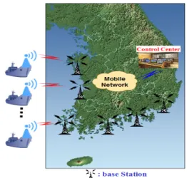
Fig 1 shows one of the several examples of vessel safety management system. Vessels are connected to the mobile network through the base station. The control center is connected to the vessels through the
base station. The safety monitoring unit of the vessel collects the vessel’s state information and detects the dangerous elements such as the collision with the neighborhood vessels. These information is transferred to the control center and the units in vessel such as crew’s Smart Phone and the dedicated terminal through the mobile network. Vessels inform the control center of its own location, speed and direction periodically.
The control center supervises the safety navigation state by receiving the vessel’s state information from many vessel’s state monitoring units and supervises and then transfers the navigation commend and information to the vessels.
Fig. 1. The overall configuration for safety management system in the coastal area[5][6][7]
그림 1. 해안 지역에서 안전 관리 시스템의 전체 구성[5][6][7]
Fig 2 shows vessels such as fishing boat, passenger
ship, leasure boat, freighter, and so on operating in the
costal area. The safety management system for vessel
in the coastal area has to include the vessel state
monitoring unit, the control center, the beacon signal
receiver. The monitoring unit for vessel’s state can
detect if the vessel is operating safely or not. This unit
monitors the shock added to vessel, the slope size and
period of three axis direction, the location information
based on the satellite navigation unit, and the
neighborhood vessel and marine structure based on the
wireless beacon transceiver. This also issues alarm by
deciding the collision and the vessel’s own dangerous state through these data.
The beacon transmitter in the vessel and the marine structure sends its own location, and the vessel’s own emergency situation through the wireless interface.
The beacon receiver in the vessel can recognize their location and the vessel’s emergency situation by receiving the beacon signals that the vessel and the marine structure send. In this configuration, the beacon signals can be exchanged among vessels, and between vessel and marine structure without the mobile network.
Fig 2. the vessels operating in the costal area[2][6][8]
그림 2. 해안 영역에서 운항 중인 선박[2][6][8]
Ⅲ. Implementation of safety equipment for small-size vessel
In the costal area, many small-size vessels are not equipped with the safety navigation equipments because of its owner’s financial hardship or their indifference. So it is desirable to provide them with these equipments in the inexpensive cost. Fig 3 shows the block diagram of safety equipment for the small-size vessel. this equipment consists of sensors for navigation, GPS/DGPS, Beacon signal transceiver, AIS signal receiver, ship safety control function, and wireless interface.
if the vessel received the beacon signals from other
objective, it calculate the direction and speed of the objectives that transmitted the beacon signals. Based on this information this equipment decides the possibility and estimated time of collision between the objectives that transmitted the beacon signal and the ship that received the beacon signal.
Fig. 3. The block diagram of the vessel safety equipment 그림 3. 선박 안전장치의 블럭도
Fig 4 shows the beacon format proposed for the safety navigation equipment of small-size vessel. The existing beacon system exchanges only the position information for each other. In this beacon format, the beacon transmitter can transfer the detail information of objectives which its transmitter belongs except of the position information. So the beacon receiver can cope with the several situations by using that information.
Fig. 4. Beacon Data format 그림 4. 비콘 데이터 형식
In this format, beacon ID is identification for beacon
transmitter. Type is the structure type transmitting the
beacon signals, such as ship, fixed artificial structure,
mobile artificial structure, fixed natural structure, and
so on. Class is the detail for type such as size,
direction, and so on. Latitude and Longitude is the
position information of Beacon transmitter.
Fig 5 shows the flow chart for vessel safety equipment, This equipment calculates the direction and speed of the objectives based on the beacon signals received from other objective. if there can be the possibility for collision. This equipment performs the following operation;
Fig. 5. The flow chart for vessel safety equipment 그림 5. 선박 안전장치의 동작 흐름도
If the estimated time of collision is smaller than the assigned time1(Tw) and larger than the assigned time1(Ta), The warning will be issued. f the estimated time of collision is smaller than the assigned time2(Ta), The alarm signal will be issued. In the case of alarm signal, the ship transfer the alarm signal to smart phone in this ship and the control center through the wireless interface. If the alarm signal lasts for the assigned time, the ship decides this is the dangerous situation. Then the vessel informs other vessels of this situation through the beacon signal including this alarm information.
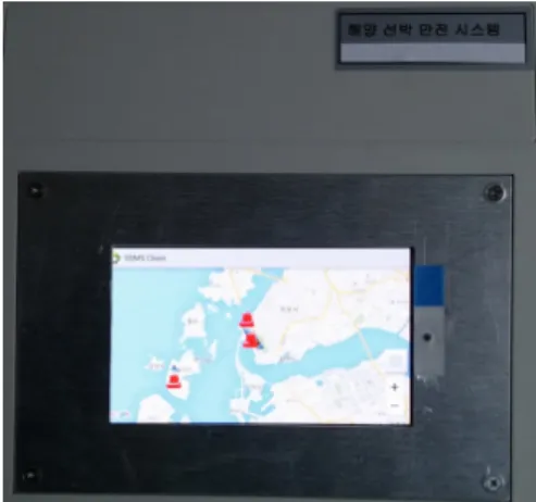
Fig 6 shows The safety equipment for small-size vessel. This equipment includes GPS, the sensors for vessel’s state, AIS receiver, the beacon signal transceiver, and the wireless interface. This system can be operated by two modes such as simulation and GPS.
This system is assigned to operate in GPS mode. This mode display the vessels’s location on the window of this equipment after receiving AIS signals from other vessels.
Fig. 6. The safety equipment for small-size vessel 그림 6. 소형 선박용 안전장치
The function to gather information about the vessel’s state gathers the vessel’s diverse state information through the diverse sensors installed in the vessel and then transfer this information to the vessel’s safety control function.
This information includes the vessel’s shaking information such as roll, pitch, and taw and the acceleration information of x, y, and y axis direction to detect the impulse added to the vessel and the state information of engine and navigation units and the flooding information.
Fig 7 shows the vessel state. This includes Pitch, roll, and yaw. This motion for vessel can be detected by Gyro and three axis accelerometer. Pitch, Roll, and Yaw value can be detected from Gyro sensor. Three axis accelerometer is used to detect the collision and shock of vessel.
Fig. 7. The vessel state 그림 7. 선박 상태
Fig 8 indicates the vessel’s own state according to Fig 7. In Fig 8, a) shows the rolling state for the vessel, and b) shows the pitching state for the vessel. The possibility for vessel accidents, such as stranding, sinking can be detected. So the vessel can cope with the accidents.
Fig. 8. Indication of vessel’s own state 그림 8. 선박 자체 상태 표시
Detected neighbors vessels and objectives are displayed with their distance. In this case, Ships and fixed obstacles are displayed differently.
When neighbor beacon located in 50 meters area, change the mark of neighbor vessel’s color red on the display. When collision with neighbor ship is estimated in 10 second by calculation of speed & direction.
The mark of neighbor vessels start to blinking once a second. When estimated collision time is getting closed to zero, then blinking cycle time is getting shorter. When mark of neighbor is blinking, then beep alarm sound with same blinking cycle is generated.
Volume of Beep alarm sound is getting bigger, when blinking cycle is getting shorter.
Fig. 9. Indication of location for the nearby vessels 그림 9. 주변 선박의 위치 표시
IⅤ. Conclusion
The existing safety navigational systems have been developed for just the large-scale vessels. So the price of this system is so high that it is difficult for the medium/small-size vessels to equip with this system.
In this paper, the inexpensive safety management equipment for the small-size vessel in the coastal area has been developed. So for the safety of small size vessels in the coastal area, the marine accidents such as stranding, sinking, collision, and so on, can be protected in advance or the occurred accidents can be treated quickly. This equipment can guarantee the safety of small size vessels in defenseless state considerably.
References
[1] Roste, T.; Kun Yang; Bekkadal, F., “Coastal coverage for maritime broadband communications”, OCEANS - Bergen, 2013 MTS/IEEE, pp1∼8, 2013.
DOI: https://doi.org/10.1109/oceans-bergen.2013.
6608109.
[2] Shu ping Zhao; Chun yu Zhao, “Modern ship-to-shore data communications technology”, Electric Information and Control Engineering (ICEICE), 2011 International Conference on, pp4280∼4283, 2011.
doi : https://doi.org/10.1109/iceice.2011.5777287.
[3] GMDSS Communications & radio-Global Maritime
Distress and Safety System,
http://www.gmdsscom.co.uk/
[4] e-Navigation, http://en.wikipedia.org/wiki/E-Navigation [5] Gianmarco Baldini, David Shaw, Franc Dimc. “A
Communication Monitoring System To Support Maritime Security”, 52
ndInternational Symposium ELMAR-2010, pp243∼246, September 2010.
[6] W. Su, K. Peng-Yong, J. Shankar, W. Haiguang,
G. Yu, and A. Chee-Wei, "A Novel Framework
to Simulate Maritime Wireless Communication
Networks," in OCEANS 2007, pp1~6, 2007.
DOI: https://doi.org/10.1109/oceans.2007.4449340.
[7] P.A.M. Silveira, A.P. Teixeira and C. Guedes Soares, “Use of AIS Data to Characterise Marine Traffic Patterns and Ship Collision Risk off the Coast of Portugal”, THE JOURNAL OF NAVIGATION, 66, pp879∼898, 2013.
DOI: https://doi.org/10.1017/s0373463313000519.
[8] T.L. Yip, “A Marine Traffic Flow Model”, The International Journal on Marine Navigation and Safety of Sea Transportation, Vol7, No1. pp109∼
113, 2013.
DOI: https://doi.org/10.12716/1001.07.01.14.
[9] Seung-Hee Oh; Daehee Seo; Byunggil Lee;
Byungho Chung, “Mutual Authentication between Ships in the E-Navigation Environment”, Security Technology (SecTech), 2014 7th International Conference on, pp15∼18, 2014.
DOI: https://doi.org/10.1109/sectech.2014.11.
저자 소개 박 천 관(종신회원)
∙2016년 12월호(Vol. 16, No. 6) 참조
![그림 2. 해안 영역에서 운항 중인 선박[ 2][6][8]](https://thumb-ap.123doks.com/thumbv2/123dokinfo/5408140.421273/3.799.88.386.398.620/그림-해안-영역에서-운항-중인-선박.webp)