https://doi.org/10.17820/eri.2016.3.4.285 Online ISSN: 2288-8527 ORIGINAL ARTICLE
안정하도 설계에 따른 물리적 교란개선 평가와 서식적합도 분석
Physical Disturbance Improvement Evaluation and Habitat Suitability Analysis by Stable Channel Design
이웅희ㆍ최흥식*
상지대학교 건설시스템공학과
Woong Hee Lee and Heung Sik Choi*
Department of Civil Engineering, Sangji University, Wonju 26338, Korea
Received 31 October 2016, revised 30 November 2016, accepted 20 December 2016, published online 31 December 2016
ABSTRACT: This study conducted the evaluations of stable channel and physical disturbance improvement for optimal construction of river structures by focusing on Wonju River. A stable slope was analyzed sectionally for stable channel design, and in order to satisfy the stable slope, river structure improvement scenarios were deduced. Accordingly, through physical disturbance improvement evaluation for each scenario, the study extracted the optimal scenario for stable channel design and physical disturbance improvements. The changes in physical habitat were analyzed when river structure improvements were made for stable channel design and physical disturbance improvement. Zacco koreanus, an indicator fish of the soundness of the aquatic ecosystem, was selected as a restoration target species by investigating the community characteristics of fish fauna and river environments in the Wonju River. The habitat suitability was investigated by the PHABSIM model with the habitat suitability index of Zacco koreanus. The results of the prediction evaluation showed a slight decrease in habitat suitability and weighted usable area. However, it was not influenced by the improvements in the river structure. The study suggested river structure arrangement methods that can improve physical soundness and safety of Wonju River, and confirmed that there were no effects to the changes in the physical habitat.
KEYWORDS: Habitat suitability, Physical disturbance improvement, Stable channel, Structure arrangement
요 약: 본 연구는 원주천을 대상으로 하천시설물의 최적 설계를 위한 안정하도 평가와 물리적 교란개선 평가를 수행하였다. 안정하도 설계를 위한 구간별 안정경사를 분석하였으며, 안정경사를 만족하기 위한 하천시설물의 개선 시나리오를 도출하였다. 그에 따라 각 시나리오에 대한 물리적 교란개선 평가를 통해 안정하도 설계와 물리적 교란개선을 위한 최적의 시나리오를 선정하였다. 아울러 안정하도 설계와 물리적 교란개선을 위한 하천시설물의 개선 시 물리 서식처의 변화를 분석하였다. 원주천의 하천 환경조사와 어류의 군집특성을 이용하여 수중 생태계를 대표할 수 있는 복원 목표어종으로 참갈겨니를 선택하였다. 참갈겨니의 서식적합지수를 사용한 서식적합도 분석은 PHABSIM 모형을 이용하였다. 예측 평가를 수행한 결과 서식적합도와 가중가용면적은 소폭 감소하는 것으로 나타났으나, 하천시설물의 개선에 따른 영향은 아닌 것으로 나타났다. 따라서 원주천의 물리적 건전성과 안정성을 제고할 수 있는 하천시설물의 배치 방안을 제시하였으며, 그에 따른 물리 서식처의 변화는 영향이 없는 것을 확인하였다.
핵심어: 서식적합도, 물리적 교란개선, 안정하도, 시설물 배치
*Corresponding author: [email protected], ORCID 0000-0001-9703-3199
ⓒ Korean Society of Ecology and Infrastructure Engineering. All rights reserved.
This is an open-access article distributed under the terms of the Creative Commons Attribution Non-Commercial License (http://creativecommons.org/licenses/by-nc/3.0/), which permits unrestricted non-commercial use, distribution, and reproduction in any medium, provided the original work is properly cited.
285
Fig. 1. Map showing the Wonju River basin and the investigated river reach.
1. 서 론
최근 자연진화적 하천환경의 조성과 하천생태계의 건 전성 확보를 위한 다양한 형태의 하천복원사업이 실시되 고 있다. 이·치수 및 경관·환경을 위한 하천의 정비가 실시 되고 있으며, 다양한 형태의 하천시설물이 설치되고 있다.
하천시설물의 설치는 주수로 내에서의 수리적 특성과 하 천단면의 기하학적 특성의 변화를 가져오며, 이는 하천의 물리적 교란으로 발생된다. 하도에서의 물리적 교란은 하 천의 선형을 변화시키며, 하중도, 여울, 소 등의 생성과 소 멸을 발생시킨다. 이러한 물리적 교란은 다시금 수리적 특 성을 변화시키며, 하상변동과 더불어 하천에서 물리서식 처의 교란으로 생태계를 교란시킨다.
그에 따라 미국 (SVAP, Stream Visual Assessment Protocol)과 호주 (AUSRIVAS, Australian River Assessment System), 독일 (LAWA, Laenderarbeitsgemeinschaft Wasser), 중국 (TRA, Technical Regulation for Assessment of River-Health) 등은 지역적 특성에 맞는 교란평가 방법 을 자체적으로 개발하여 하천에 대한 건강성과 변화 양상 을 평가하고 있다 (USDA 1998, Environment Australia 2000, LAWA 2000, CRAES 2012). 최근에는 다양한 연구자들에 의해 하천의 인위적 교란에 따른 하천의 유형 별 지형변화에 대한 체계적인 분석기법이 제시되고 있으 며 (Ministerium für Umwelt 2005, Hesselink et al.
2006, Choi and Lee 2014), 하천관리를 위한 물리적 하 천교란의 분석 방법이 제시되고 있다 (Jo 1997, Stein et al. 2002, Choi et al. 2015). 더불어 물리적 교란과 생물상 변 화 및 서식처 교란 등을 규명하기 위한 연구가 현장조사와 수 치모의 방법 등을 이용하여 분석되고 있다 (Scott et al. 2005, Choi et al. 2010, Jia and Chen 2013, Choi and Lee 2015).
아울러 최근에는 하천복원 및 설계, 하천시설물의 도입 등에 있어 안정하도 개념을 통한 하천관리 방안이 제시되 고 있다 (Soar and Thorne 2001). 안정하도란 침식과 퇴 적이 지속적으로 변화하지만 장기적으로 평형을 이루는 하천을 의미한다 (Ji and Jang 2015). 안정하도 및 평형 하 천 형태를 설계하는 방법은 해석적인 평형하상 이론 혹은 경험적인 평형하상 이론에 기초하여 여러 연구자들에 의 해 제안되었으며, Copeland의 방법 (Copeland 1994)이 안정하도 평가 및 설계에 가장 널리 이용되고 있다 (Ji et al.
2010). 하도의 안정성을 최대화하면서 동시에 하천 유지 관리 작업을 최소화할 수 있는 복합적인 목표를 만족시키
는 하천 복원 설계안으로써 안정하도 설계기법은 하천 복 원 설계 시 가장 선행되어야 할 작업이며, 하천 및 하도의 안정성에 대한 평가를 위한 평형 하천의 개념으로 반드시 고려해야 된다 (Ji and Jang 2015).
따라서 본 연구에서는 안정하도 설계를 위한 하천시설 물의 개선 ․ 재배치 ․ 철거 시나리오의 개발과 그에 따른 하 상변동 및 물리적 교란과 물리적 서식적합도의 변화 양 상을 분석하였으며, 하천의 건전성과 하도의 안정성을 제고할 수 있는 하천시설물의 최적 배치 방안을 도출하 였다.
2. 연구방법
2.1 대상하천의 선정
본 연구에서는 원주천 일부 구간에 대하여 하천교란 적 응관리 시스템을 적용하였다 (Fig. 1). 원주천은 총 25.66 km이며, 유역면적은 152.92 km2, 하상경사는 1/320이 다. 대상구간은 원주천의 최하류인 섬강합류부에서부터 상류로 16 km 구간에 대한 안정하도와 물리적 교란개선 평가를 수행하였다. 대상구간 내에는 총 7개의 횡단시설 물인 보가 설치되어 있다. 원주천의 경우 지속적인 생태하 천조성사업이 이루어졌으나, 하천 생태계의 건강성은 떨 어지는 것으로 나타났으며, 도시의 발전에 따른 목적을 상 실한 취입보가 많이 설치되어 있어 시설물 개선과 철거의 하천사업이 필요한 실정이다.
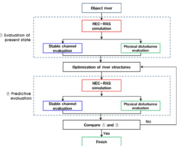
Fig. 2. Process of adaptive management system. Fig. 3. Permission range of stable slope.
2.2 하천교란 적응관리 시스템 2.2.1 시스템의 구성
하천교란 적응관리 시스템은 Fig. 2와 같은 과정으로 진행된다. 우선 평가하고자 하는 대상하천 구간에서의 HEC- RAS 수치모의에 따른 수리, 하상특성을 통해 안정하도 평 가를 수행하게 되며, 현재상태에 대한 물리적 교란개선 평 가를 수행한다. 이후 안정하도 평가에서 불안정 평가가 나 타난 지점에 대하여 하천시설물의 도입, 개선, 철거 등의 최적화 작업이 진행되며, 개선된 시설물의 규모와 위치에 따른 1년간의 하상변동 모의 결과를 통해 안정하도와 물리 적 교란개선 평가를 재 수행한다. 마지막으로 현재 상태와 비교를 통해 안정하도 설계와 물리적 교란 저감 양상을 분석 하여 하천시설물의 최적 배치 방안을 도출하게 된다.
2.2.2 하상변동 수치모의
본 연구에서는 1차원 수리, 하상변동 해석 프로그램인 HEC-RAS를 이용하여 하천시설물의 개선에 따른 수리, 하상변동 특성을 분석하였으며, 그에 따른 안정하도 평가 와 물리적 교란개선 평가를 수행하였다. 수치모의를 위해 사용된 하상자료는 2014년 실측된 자료를 이용하였으며, 유량자료는 국가수자원관리종합정보시스템에서 제공하 는 2014년의 1년간 실측 유량자료를 이용하였다. 횡단면 은 대상구간 16 km에 20개 지점을 이용하여 수치모의를 진행하였다. 하상재료와 유사량은 원주천 하천기본계획 (1999)의 자료를 이용하였으며, 유사이송공식은 Yang 공 식을 이용하여 하상변동 양상을 분석하였다. 원주천의 대 표입경은 0.0199 m로 자갈하상의 특성을 나타내며, 조도 계수는 0.03이다.
2.2.3 안정하도 평가
안정하도 평가는 안정하도 단면의 계산을 통한 수심과 안정경사관계곡선을 산정함에 따라 수심에 해당되는 경사 를 통해 안정경사를 확인하고 평가한다. 안정하도 평가를 위해 사용되는 변수로는 하도형성유량으로 지점에서의 만 제유량을 사용하며, 하상토의 비중, 사면경사, 흐름저항계 수, 하상토 입경, 유입유사농도가 사용된다. 최종적으로 4 개의 유사이송공식 중 한가지를 선택하여 안정경사관계곡 선을 산정하게 된다. Ji and Jang (2015)은 원추천에 대한 안정하도 평가 및 설계를 위해 Ackers and White (1973), Brownlie (1981), Meyer-Peter and Müller (1948)과 Engelund-Hansen (1967) 공식을 이용하였다. 하폭의 변화 가 제한된 조건에서의 안정경사를 분석한 결과 Engulend- Hansen 공식이 가장 완만한 경사를 나타내는 것으로 확인 되었다. 따라서 본 연구에서는 안정하도 설계에 따른 물리 적 하천교란이 최대로 발생할 수 있는 Engelund-Hansen 공식을 적용하였다. 대상하천 16 km를 총 20개 구간으로 분할하여 각 구간의 안정경사를 평가 하였으며, 수심에 해 당하는 안정경사를 분석하였다. 안정경사에 따른 안정/불 안정 판단에서는 Fig. 3과 같이 안정경사 허용범위를 정의 하여 허용범위 내에 속하는 경사에서 안정을 판단하였다. 적용한 허용범위는 하천에서 시설물의 안정에 있어 유사 의 퇴적 보다는 침식에서 그 피해가 가중될 것이라고 판단 하여 안정경사 보다 경사가 급한 경우에는 10%의 허용범 위를 적용하였으며, 안정경사 보다 완경사인 경우에는 50%의 허용범위를 적용하였다.
2.2.4 물리적 교란개선 평가
물리적 교란개선 평가는 Choi et al. (2015)이 제시한 방법을 이용하였다. 물리적 교란개선 평가 방법은 HEC-
Table 1. Flow regime at the Wonju observation station of Wonju River.
Flow type Flow (m3/s)
Drought flow (Q355) 0.401
Low flow (Q275) 0.885
Ordinary flow (Q185) 1.596 Abundant flow (Q95) 3.095
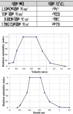
Fig. 4. Habitat suitability index of Zacco koreanus.
RAS 수치모의 결과와 현장데이터를 이용하여 하상서식 환경, 하상재료, 수심상황, 유사퇴적, 하도흐름상태, 하도 정비상태, 여울출현빈도, 하안안정성, 식생피복, 하반림 등 총 10개 항목에 대한 교란 양상을 평가한다. 각 항목에 서 0점~20으로 총 200점으로 평가되며, 200~160은 우 수, 160~120은 양호, 120~80은 보통, 80미만은 빈약한 교란개선 상태로 평가된다. 여기서 평가 점수는 물리적 교 란의 발생 정도를 나타내는 정량적 수치가 아니며, 대상구 간에서의 물리적 교란 상태를 나타내는 수치이다. 즉 물리 적 교란개선 평가점수가 증가함은 대상구간에서 물리적으 로 교란 양상이 건전화 되었음을 의미한다.
2.3 물리서식처 평가
물리서식처의 분석을 위해 PHABSIM 모형을 이용하 여 서식적합도 (HS, Habitat suitability)와 가중가용면적 (WUA, Weighted usable area)을 분석하였다. Table 1
은 원주천의 유황을 나타내며, 평수량 1.596 m3/s에서의 물리서식처를 분석하였다. 복원 목표어종은 원주천 중류 에 우점종으로 서식하고 있는 참갈겨니를 선정하였다. 복 원 목표종을 우점종으로 선택함은 개체수가 많은 어종의 서식적합도 분석 결과가 신뢰성을 높일 수 있기 때문이다 (Bovee et al. 1998). 서식적합도 분석은 산란기, 치어기, 성어기 각각의 성장 단계별 분석이 필요하지만 서식처 수 리조건이 산란기의 경우 대부분 4~5월로 편중되어 있고 치어기의 경우 여름~가을로 그 기간이 짧으며, 성어기는 봄에서 가을로 동절기를 제외한 대부분의 연중이라 할 수 있으므로 성어의 수리조건을 기준으로 서식적합도를 분석 하였다. 성어기 참갈겨니의 수리조건에 따른 서식적합지 수는 Fig. 4와 같으며, 수심 0.15 ~ 1.2 m와 유속 0 ~ 1.5 m3/s의 범위에서 서식지적합도가 산정된다.
3. 결과 및 논의
3.1 시나리오의 생성
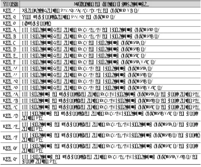
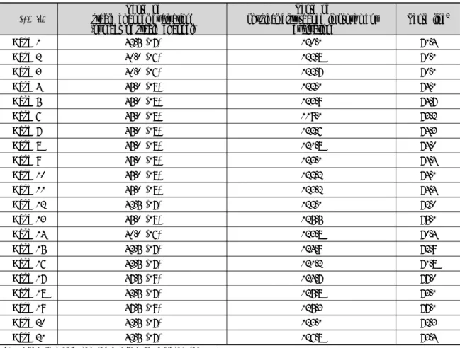
원주천의 안정하도 설계와 물리적 교란 저감을 위해 하 천시설물 개선 시나리오를 생성하였으며, 현재상태를 포 함한 총 21개 시나리오를 적용하였다. Table 2는 본 연구 에서 적용된 시나리오로 하천시설물의 설치위치와 시설물 높이를 나타낸다. Case 1은 현재상태로 7개의 시설물이 11, 12, 14, 16, 17, 18번 지점에 3 m와 5 m로 설치되어있 다. Case 2는 14, 16, 17 18 지점의 5개 시설물을 철거한 후 11, 12 지점에 3 m의 시설물이 2개소가 남아있는 상태 에서 1년간 하상변동 모의를 수행한 후 평가한 경우로 현 재 원주시의 시설물 철거계획에 따른 시나리오를 나타낸 다. Case 3은 모든 하천시설물을 철거한 상태에서 1년간 하상변동 모의를 수행한 후 평가한 경우이다. Case 4 - 21 은 case 1의 안정하도 평가 결과에 따라 불안정으로 판정 된 지점에 대하여 안정경사를 만족하기 위해 경사제어 낙 차공을 지점별, 규모별로 다르게 적용하여 1년간 하상변 동 모의 결과에 따라 평가한 경우이다.
3.2 안정하도와 물리적 교란개선 평가 결과 Table 3은 case 1의 현재 상태에 대한 안정하도 평가 결 과이다. 총 20개 지점에서 17개 지점이 안정경사를 만족 하는 것으로 나타났으며, 2번, 5번, 19번 지점에서 불안정 경사로 나타났다. Table 4는 case 1에 대한 물리적 교란개
Table 2. Scenarios for the regulation of river structures.
Scenario Explanation and location of river structures Case 1 Present state: section (11, 12, 14, 16, 17, 18) and height (3 - 5 m) Case 2 Some weir removal: section (11, 12) and height (3 m)
Case 3 All weir removal
Case 4 Add drop structure: add section (3, 6, 18, 19) and drop structure height (0.3 m) Case 5 Add drop structure: add section (3, 6, 18, 19) and drop structure height (0.5 m) Case 6 Add drop structure: add section (3, 6) and drop structure height (0.4 m) Case 7 Add drop structure: add section (3, 6) and drop structure height (0.5 m) Case 8 Add drop structure: add section (3, 6) and drop structure height (0.6 m) Case 9 Add drop structure: add section (3, 6) and drop structure height (0.4 - 0.6 m) Case 10 Add drop structure: add section (3, 6, 19) and drop structure height (0.4 m) Case 11 Add drop structure: add section (3, 6, 19) and drop structure height (0.5 m) Case 12 Add drop structure: add section (3, 6, 19) and drop structure height (0.5 m) Case 13 Add drop structure: add section (3, 6, 19) and drop structure height (0.5 - 0.6 m)
Case 14 Add drop structure and weir removal: add section (3, 6, 9), drop structure height (0.4 m) and remove section (18) Case 15 Add drop structure and weir removal: add section (3, 6, 19), drop structure height (0.5 m) and remove section (18) Case 16 Add drop structure and weir removal: add section (3, 6, 19), drop structure height (0.6 m) and remove section (18) Case 17 Add drop structure and weir removal: add section (3, 6, 19), drop structure height (0.5 - 0.6 m) and remove section (18)
Case 18 Add drop structure and weir removal: add section (3, 6, 18, 19), drop structure height (0.4 m) and remove section (18)
Case 19 Add drop structure and weir removal: add section (3, 6, 18, 19), drop structure height (0.5 m) and removal section (18)
Case 20 Add drop structure and weir removal: add section (3, 6, 18, 19), drop structure height (0.6 m) and remove section (18)
Case 21 Add drop structure and weir removal: add section (3, 6, 18, 19), drop structure height (0.4 - 0.5 m) and remove section (18)
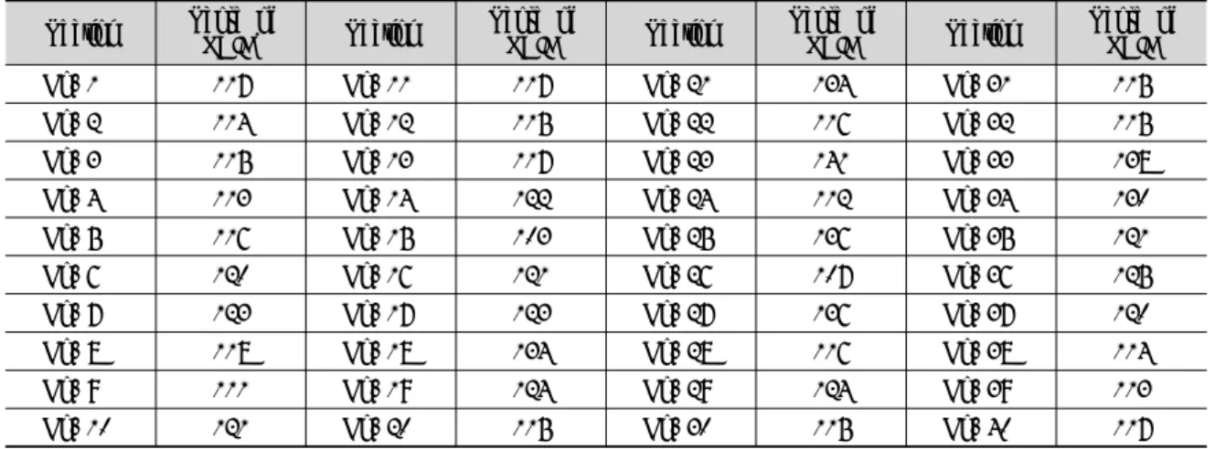
선 평가결과를 나타낸다. 현재상태의 경우 구간별로 최소 103.0점의 보통의 평가 결과에서 최대 141.0점으로 양호 한 평가 결과를 나타냈으며, 총 구간 평균 120.1점으로 양 호한 상태로 나타났다. 이와 같은 방법으로 cases 2~21까 지의 시나리오에 대한 안정하도 평가와 물리적 교란개선 평가를 수행하였으며, 그에 따라 Table 5와 같은 결과가 나타났다. 평가결과의 통일과 비교를 위해 안정하도 평가 결과의 안정판단 구간 개수와 교란평가 점수를 기하평균 하여 적응관리 시스템의 최종점수로 비교하였다.
분석결과 안정하도 평가 결과는 case 17과 case 19에서 총 20개 구간 중 19개 구간에서 안정경사로 나타남을 확인 하였다. 물리적 교란개선 평가 결과는 case 21에서 구간평 균 126.8점으로 가장 양호한 평가로 나타났다. 최종 분석 결과 case 19의 하천시설물 설계 시나리오에서 안정하도 설계와 물리적 교란개선의 최적화가 가능한 것으로 나타 났다. Case 19는 1, 2, 19번 지점에 경사제어 낙차공을 0.5
m의 높이로 설치하고 18번 지점의 시설물을 제거한 경우 이다. 현재 상태와 비교 결과 5번과 19번 지점에서 안정경 사의 평가로 변화함을 확인하였으며, 현재상태 보다 안정 하도 구간이 증가함을 확인하였다.
물리적 교란개선 평가 결과에 대하여 이수 기능을 상실 한 시설물을 제거한 case 2와 모든 시설물을 제거한 case 3 및 최적 시나리오로 나타난 case 19를 현재상태인 case 1과 비교한 결과는 Fig. 5와 같다. 분석결과 case 2와 3의 경우 물리적 교란개선 평가 결과가 16 km 전반에 걸쳐 소 폭 향상됨을 확인하였다. Case 19의 경우 현재상태 보다 평균 5.18점이 증가하는 것으로 확인되었으며, 중상류 지 점에서의 물리적 교란개선 평가결과가 향상되는 것을 알 수 있었다. 이에 따라 본 연구에서 진행한 하천교란 적응관 리 시스템을 통하여 하천의 안정성과 교란개선에 대한 평 가가 가능하며 하천시설물의 최적 설계 기법의 제시가 가 능함을 확인하였다.
Table 3. Stable channel evaluation of the scenario case 1.
Section Distance (m) Elevation (El. m) Slope Stable slope Error range Evaluation
No. 1 768 86 0.00429 0.00725 0.00798 0.00363 Stable
No. 2 745 88 0.00295 0.01050 0.01155 0.00525 Unstable
No. 3 777 90 0.00296 0.00345 0.00380 0.00173 Stable
No. 4 846 93 0.00367 0.00513 0.00564 0.00256 Stable
No. 5 807 95 0.00174 0.00388 0.00426 0.00194 Unstable
No. 6 817 98 0.00428 0.00592 0.00651 0.00296 Stable
No. 7 833 101 0.00324 0.00374 0.00411 0.00187 Stable
No. 8 831 104 0.00349 0.00331 0.00364 0.00166 Stable
No. 9 791 105 0.00114 0.00208 0.00229 0.00104 Stable
No. 10 801 107 0.00337 0.00550 0.00605 0.00275 Stable
No. 11 816 110 0.00294 0.00490 0.00539 0.00245 Stable
No. 12 803 115 0.00685 0.00779 0.00857 0.00390 Stable
No. 13 798 120 0.00627 0.00861 0.00947 0.00431 Stable
No. 14 809 123 0.00408 0.00495 0.00545 0.00248 Stable
No. 15 781 130 0.00819 0.01602 0.01762 0.00801 Stable
No. 16 801 136 0.00774 0.01277 0.01405 0.00639 Stable
No. 17 781 144 0.01076 0.01450 0.01595 0.00725 Stable
No. 18 785 153 0.01121 0.01843 0.02027 0.00922 Stable
No. 19 822 163 0.01168 0.02707 0.02978 0.01354 Unstable
No. 20 791 172 0.01201 0.01690 0.01859 0.00845 Stable
Table 4. Physical disturbance improvement evaluation of scenario case 1.
Section Score of
PDIE1 Section Score of
PDIE Section Score of
PDIE Section Score of
PDIE
No. 1 117 No. 11 117 No. 21 134 No. 31 115
No. 2 114 No. 12 115 No. 22 116 No. 32 115
No. 3 115 No. 13 117 No. 23 141 No. 33 138
No. 4 113 No. 14 122 No. 24 112 No. 34 130
No. 5 116 No. 15 103 No. 25 136 No. 35 121
No. 6 120 No. 16 121 No. 26 107 No. 36 125
No. 7 123 No. 17 123 No. 27 136 No. 37 120
No. 8 118 No. 18 134 No. 28 116 No. 38 114
No. 9 111 No. 19 124 No. 29 124 No. 39 113
No. 10 121 No. 20 115 No. 30 115 No. 40 117
1PDIE: Physical Disturbance Improvement Evaluation.
3.3. 물리서식처 평가 결과
원주천에서 현상태의 경우 참갈겨니의 HS는 21, WUA 는 508 m2으로 나타났다 (Table 6). 대상 구간에서의 HS 와 WUA는 단면 별 값을 합산하여 구간에 대한 총 HS와 WUA로 분석하였다. 또한 HEC-RAS 수치모의를 통해
현재상태에서의 5년 후 하상변동에 따른 참갈겨니의 물리 서식처를 분석한 결과 HS는 19, WUA는 403 m2으로 나 타났다. 아울러 하천교란 적응관리 시스템에 의해 결정된 case 19의 시설물 설치 후 하상변동 모의와 그에 따른 물리 서식처를 분석한 결과 HS는 19, WUA는 382 m2으로 나 타났으며, 현상태에서 5년 경과 후의 결과와 생물학적 교
Table 5. Evaluation results of adaptive management system of river disturbance.
Scenario Score of
stable channel evaluation1 (number of stable channel)
Score of
physical disturbance improvement
evaluation Score line2
Case 1 42.5 (17) 120.1 71.4
Case 2 40.0 (16) 122.8 70.1
Case 3 40.0 (16) 122.7 70.1
Case 4 45.0 (18) 122.1 74.1
Case 5 45.0 (18) 123.9 74.7
Case 6 45.0 (18) 119.1 73.2
Case 7 45.0 (18) 122.6 74.3
Case 8 45.0 (18) 121.8 74.0
Case 9 45.0 (18) 123.1 74.4
Case 10 45.0 (18) 122.2 74.1
Case 11 45.0 (18) 123.2 74.4
Case 12 42.5 (17) 122.1 72.0
Case 13 45.0 (18) 125.5 75.1
Case 14 40.0 (16) 123.8 70.4
Case 15 42.5 (17) 124.9 72.9
Case 16 42.5 (17) 121.2 71.8
Case 17 47.5 (19) 124.7 77.0
Case 18 42.5 (17) 125.8 73.1
Case 19 47.5 (19) 125.3 77.1
Case 20 42.5 (17) 123.1 72.3
Case 21 42.5 (17) 126.8 73.4
1(Number of stable section/number of total section) × 50
2(Score of stable channel evaluation×score of PDIE)^0.5
T\able 6. Results of physical habitat suitability simulation.
Classification Sum of habitat suitability
along river reach Sum of weighted usable area along river reach (m2)
Case 1 (present) 21 508
After 5 years
(without optimization) 19 403
After 5 years
(optimized design of river structures) 19 382
(a) After 5 years (present) (b) After 5 years (optimized design of river structures) Fig. 6. Comparisons of physical habitats 5 years after present condition and the optimized design of river structures.
The dotted line indicates trend line of each case.
란 양상은 유사하게 나타남을 확인하였다 (Fig. 6). 즉, 원 주천 대상구간에서 하천교란 적응관리 시스템을 통한 안 정하도 설계와 하천시설물의 최적 설계 시 안정하도 구간 과 물리적 교란개선 평가결과는 증가하는 것을 확인하였 으며, 생물학적 교란은 현재상태에서 소폭 감소하나, 시설 물의 최적 설계 여부와 상관 없이 감소하는 것으로 하천교 란 적응관리 시스템에 따른 영향이 아님을 확인하였다.
4. 결 론
본 연구는 하천의 안정성과 건강성 향상을 위해 하천교 란 적응관리 시스템을 이용하여 안정하도 설계와 물리적 교란개선 평가를 수행하였으며, 하천시설물의 최적 배치 방안을 제시하였다. 또한 시설물 최적 배치에 따른 물리적 교란과 서식적합도의 변화 양상을 비교하였다. 연구결과 를 요약하면 다음과 같다.
1) 하천의 안정성과 건강성 증대를 위하여 안정하도 평가 방법과 물리적 교란개선 평가 방법을 통한 하천시설물 의 최적 배치 시나리오를 결정하는 하천교란 적응관리 시 스템을 정의하였으며, 원주천 대상구간에 적용하였다.
2) 하천교란 적응관리 시스템의 적용결과 원주천에서 안 정하도 설계와 물리적 교란의 개선을 위한 최적 시설물 규모/배치 방안을 제시하였으며, 그에 따라 안정하도 구간은 총 20개 구간 중 19개 구간에서 안정한 것으로 나타났다. 물리적 교란개선 평가결과는 현재상태보다 5.18점이 증가한 125.28점으로 양호한 상태의 교란개 선 정도로 나타났다.
3) 물리적 서식적합도 분석을 위하여 원주천의 복원목표 종으로 우점종인 참갈겨니에 대한 물리서식처를 분석 한 결과 현상태의 HS는 21, WUA는 508 m2으로 나타 났으며, 현상태에서 5년 후 HS는 19, WUA는 403 m2 으로 소폭 감소함을 확인하였다.
4) 하천교란 적응관리 시스템을 통한 시설물의 최적 배치 에 따른 5년 후 물리서식처를 분석한 결과 HS는 19, WUA는 382 m2으로 나타났으며, 현상태에서 5년 경 과 후의 결과와 물리적 서식적합도의 변화 양상은 유사 하게 나타남을 확인하였다.
5) 원주천의 하천교란 적응관리 시스템을 적용한 결과 하 천시설물의 최적 설계에 따른 안정하도와 물리적 교란 개선 평가는 향상됨을 확인하였으나, 물리적 서식적합
도의 향상은 확인하기 어려웠다.
6) 하천교란 적응관리 시스템의 구축에 의해 원주천의 하 도 안정성과 물리적 교란개선 및 물리서식처의 확보를 위한 하천시설물의 최적 설계방안을 제시하였다.
감사의 글
본 연구는 국토교통부 물관리연구사업의 연구비지원 (12기술혁신C02)에 의해 수행되었습니다.
References
Ackers, P. and White, W.R. 1973. Sediment transport:
new approach and analysis. Journal of Hydraulics Division, ASCE 99: 2041-2060.
Bovee, K.D., Lam, B.L., Bartholow, J.M., Stalnaker, C.B., Taklor, J. and Henriksen, J. 1998. Stream Habitat Analysis Using the Instream Flow Incremental Methodology. Biological Resources Division Information and Technology Report, USGS, Fort Collins, Colorado, USA.
Brownlie, W.R. 1981. Prediction of Flow Depth and Sediment Transport in Open Channels Report No.
KH-R-43A, Institute of Technology, California, USA.
Choi, G.W., Kim, H.J., Park, J.S. and Han, M.S. 2010.
Hydromorphological structure assessment of urban streams after close-to-nature stream restoration using LAWA. Journal of Korea Water Resources Association 43: 421-431. (in Korean)
Choi, H.S. and Lee, W.H. 2014. Analyses of riverbed changes and physical disturbance evaluations by weir installation in a reach. Journal of the Korean Society of Civil Engineers 34: 1203-1213. (in Korean)
Choi, H.S. and Lee, W.H. 2015. A correlation analysis between physical disturbance and fish habitat suitability before and after channel structure rehabilitation. Ecology and Resilient Infrastructure 2: 33-41. (in Korean) Choi, H.S., Shim, K.R. and Lee, W.H. 2015. An
improvement and applicability of physical disturbance evaluation technique by quantification in river system.
Journal of Wetlands Research 17: 209-220. (in Korean) Copeland, R.R. 1994. Application of Channel Stability
Methods-Case Studies. Technical Report No. HL-94-11, United States Army Corps of Engineers. Mississippi, USA.
CRAES. 2012. Technical Regulation for Assessment of River Health. Chinese Research Academy of Environmental Sciences, Beijing, China.
Engelund, F. and Hansen, E.E. 1967. A Monograph of Sediment Transport in Alluvial Rivers. Technical
University of Denmark, Copenhagen.
Environment Australia. 2000. Australian River Assessment System: Review of Physical River Assessment Methods- A Biological Perspective. Monitoring River Health Initiative Technical Report, Report Number 21. Canberra, Australia.
Hesselink, A.W., Kleinhans, M.G. and Boreel, G.L.
2006. Historic discharge measurements in three Rhine branches. Journal of Hydraulic Engineering 132: 140-145.
Ji, U. and Jang, E.K. 2015. Stable channel design for the gravel-bed river considering design constraints.
Journal of the Korea Academia-Industrial Cooperation Society 16: 2860-2867. (in Korean)
Ji, U., Julien, P.Y., Kang, J.U. and Yeo, H.K. 2010.
Stable channel analysis and design for the abandoned channel restoration site of Cheongmi stream using regime theory. Journal of Korea Society of Civil Engineers 30: 305-313. (in Korean)
Jia, Y.T. and Chen, Y.F. 2013. River health assessment in a large river: Bioindicators of fish population. Ecological Indicators 26: 24-32.
Jo, Y.H. 1997. Development of an Evaluation Method of Stream Naturalness for Ecological Restoration of Stream Corridors. Ph.D. Dissertation, University of
Seoul, Korea. (in Korean)
LAWA. 2000. Gewässerstrukturgütekartierung in der BRD. 1. Auf. Schwerin. Länderarbeitsgemeinschaft Wasser, Stuttgart, Germany. (in German)
Meyer-Peter, E. and Müller, R. 1948. Formulas for bed-load transport. Proceeding of 2nd Meeting of the International Association for Hydraulic, International Association of Hydraulic Research Delft, Sweden, 39-64.
Ministerium für Umwelt. 2005. Gewässerstrukturgüte in Nordrhein-Westfalen. Düsseldorf, Germany. (in German) MOCT. 1999. Basic Plan for River Maintenance of
Wonju Stream. Ministry of Construction and Transportation, Gwacheon, Korea. (in Korean)
Tiegs, S.D., O’leary, J.F., Pohl, M.M. and Munill, C.L.
2005. Flood disturbance and riparian species diversity on the Colorado river delta. Biodiversity and Conservation 14: 1175-1194.
Soar, P.J. and Thorne, C.R. 2001. Channel Restoration Design for Meandering Rivers. ERDC/CHL CR-01-1, U.S. Army Corps of Engineers. Washington DC, USA.
Stein, J.L., Stein, J.A. and Nix, H.A. 2002. Spatial analysis of anthropogenic river disturbance at regional and continental scales: identifying the wild rivers of Australia. Landscape and Urban Planning 60: 1-25.
USDA. 1998. Stream Visual Assessment Protocol. National Water and Climate Center Technical Note 99-1. United States Department of Agriculture, Washington DC, USA.