1. Introduction
Forests are important carbon absorption sources. By absorbing carbon dioxide in the atmosphere through
photosynthesis and storing carbon in plants and soils, they can decrease the acceleration of global warming (KFS, 2009; Nayar, 2009). In addition, forests affect the microclimate, water circulation, and energy budget
Detection of Wildfire-Damaged Areas Using Kompsat-3 Image:
A Case of the 2019 Unbong Mountain Fire in Busan, South Korea
Soo-Jin Lee
1)· Yang-Won Lee
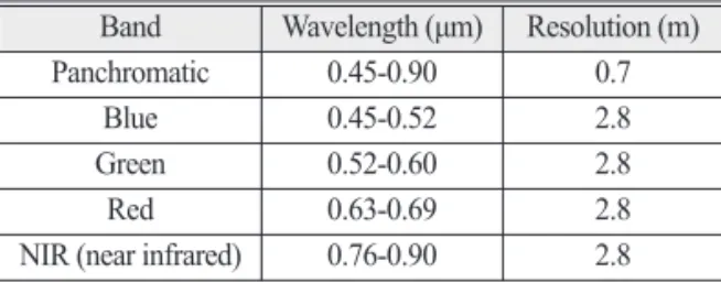
2)†Abstract: Forest fire is a critical disaster that causes massive destruction of forest ecosystem and economic loss. Hence, accurate estimation of the burned area is important for evaluation of the degree of damage and for preparing baseline data for recovery. Since most of the area size damaged by wildfires in Korea is less than 1 ha, it is necessary to use satellite or drone images with a resolution of less than 10m for detecting the damage area.
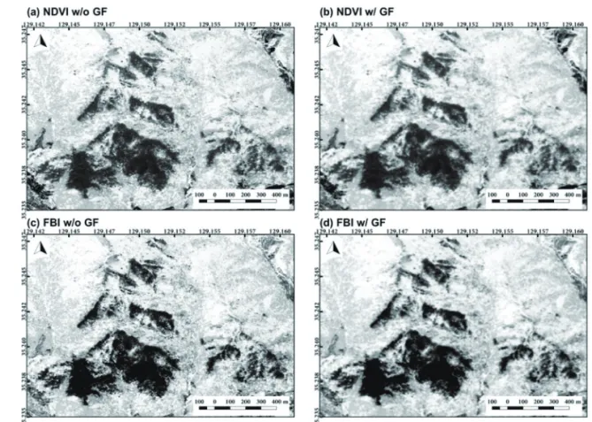
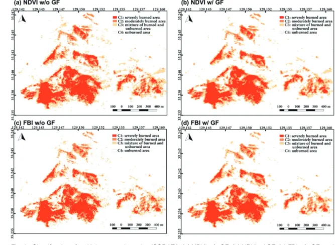
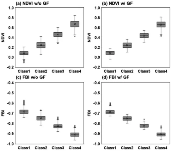
This paper aims to detect wildfire-damaged area from a Kompsat-3 image using the indices such as NDVI (normalized difference vegetation index) and FBI (fire burn index) and to examine the classification characteristics according to the methods such as Otsu thresholding and ISODATA (iterative self-organizing data analysis technique). To mitigate the salt-and-pepper phenomenon of the pixel-based classification, a gaussian filter was applied to the images of NDVI and FBI. Otsu thresholding and ISODATA could distinguish the burned forest from normal forest appropriately, and the salt-and-pepper phenomenon at the boundaries of burned forest was reduced by the gaussian filter. The result from ISODATA with gaussian filter using NDVI was closest to the official record of damage area (56.9 ha) published by the Korea Forest Service. Unlike Otsu thresholding for binary classification, since the ISODATA categorizes the images into multiple classes such as (1) severely burned area, (2) moderately burned area, (3) mixture of burned and unburned areas, and (4) unburned area, the characteristics of the boundaries consisting of burned and normal forests can be better expressed. It is expected that our approach can be utilized for the high-resolution images obtained from other satellites and drones.
Key Words: Wildfire-damaged area, Kompsat-3, Otsu thresholding, ISODATA, Gaussian filter Korean Journal of Remote Sensing, Vol.36, No.1, 2020, pp.29~39
https://doi.org/10.7780/kjrs.2020.36.1.3 ISSN 1225-6161 ( Print )
ISSN 2287-9307 (Online)
Article
Received February 10, 2020; Revised February 12, 2020; Accepted February 14, 2020; Published online February 21, 2020
1)
PhD Student, Major of Spatial Information Engineering, Division of Earth Environmental System Science, Pukyong National University
2)
Professor, Department of Spatial Information Engineering, Pukyong National University
†