1
THE ORBIT DETERMINATION TECHNIQUE OF GEOSTATIONARY SATELLITE USING STAR SENSING
FUNCTION OF THE METEOROLOGICAL IMAGER
Kim, Bang-Yeop and Yoon, Jae-Chul
Satellite Division, Korea Aerospace Research Institute [email protected], [email protected]
ABSTRACT:
A conceptual study about the angle information based orbit determination technique for a geostationary satellite was performed. With an assumption that the simultaneous observing of the earth and nearby stars is possible, we confirmed that the view angles between the earth and stars can be use as inputs for orbit determination process. By the MATLAB simulation with least square method, the convergence is confirmed. This conceptual study was performed with the COMS for instance. This technique will be able to use as a back-up of ground station’s orbit determination or a part of autonomous satellite operation.
KEY WORDS: Orbit Determination, Geostationary Satellite, Star Sensing, COMS
1. INTRODUCTION
1.1 General Information for Orbit Determination of Geostationary Satellite
Generally, most of satellites, especially the commercial communication satellite system use the radial range and angle data for the orbit determination. In this method, a ground station sends a pre-defined radio frequency signal to a satellite, and the satellite reflects the signal. When the signal reached to the ground station again, the round trip duration can be measured and it is used for orbit determination.
There are two kinds of angle data in the antenna angle data, azimuth and elevation angle. Both of them can be measured using an autonomous tracking capability. So far, currently most of geostationary satellites use the both of ranging and angle data for orbit determination in this way.
Exceptionally, an optical measuring system such like a laser ranging is used, but this method also needs the ranging information.
1.2 Orbit Determination Strategy using Angles Only In this feasibility studies, the orbit determination method was considered, which using angle data only instead of using both of ranging and angles. The angle data based orbit determination algorithm was used from a few hundreds years ago. In old days, before the appearance of optical or radio measuring systems, there was not a method to measure the range to comets or planets. So, the azimuth and elevation angle were the only input data for orbit determination.
Surely, this angle based orbit determination can be used for artificial satellite. In case of the LEO (Low Earth Orbit) satellite, the relative motion with respect to a
ground station is so varied. So, the angle based orbit determination will could be easily applied. But, in case of GEO (Geostationary Earth Orbit) satellite, the satellite’s moving appearance is so small that it is quite difficult to get a sufficient resolution of angle data. Actually, for the GEO satellite, the ground station’s antenna doesn’t need to move scarcely. So, for the GEO satellite’s orbit determination, we need additional angle data which is observed from other measuring equipment.
In our study, we turned our attention to some facts that if a GEO satellite has an optical payload and make a picture of the earth and nearby stars in a same frame we will be able to extract information to use for orbit determination. If the on-board optical sensor can observe the earth and at least two stars nearby in one frame, then we can measure the view angles among the three astronomical bodies. So, with the help of star identification algorithm, we can determine the direction coordinates of the earth as well as the inertial coordinates of stars. Simply, the opposite direction of the earth direction coordinates will be the inertial coordinates of satellite. This information can be use as the inputs for orbit determination. We noticed at this point.
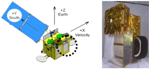
Figure 1. COMS satellite and MI
For example, in the case of COMS (Communication, Ocean and Meteorological Satellite), which will be launched at the end of 2008, the meteorological sensor
2 has a star observing function as well as the earth
observation. The meteorological imager (MI), which is primary payload, can observe both of the earth and stars in a same frame (EADS 2005). The original purpose of this star sensing function is to assist the INR (Image Navigation and Registration) system. If the land-mark on the ground can not be seen cause of a bad whether, stars can be back-up method for sensor pointing. So, with proper star catalogue and star identification method, it is possible to measure the view angle between the earth centre and stars.
With these concepts, we studied the orbit determination concepts using the view angle between the earth and stars, which observed by GEO satellite’s meteorological sensor.
In this way, as the orbit determination is possible without the ground station’s observed data so a kind of autonomous orbit determination can be available. At least, it can be use as a backup data gathering method.
In this research, we studied an orbit determination strategy when the view angle between the earth centre and stars were used as the input data.
In advance to start, we have to explain an assumption.
Actually, the MI of COMS doesn’t support the simultaneously observing mode. The star observation mode is separated from the earth observing mode.
Because it uses a linear CCD (Charged Coupled Device) as the imaging device so it can not collect the earth and star images simultaneously. But the observing times of each target are able to know. So, in this study we assumed that the meteorological sensor is able to observe the earth and stars simultaneously or it is able to know the observed time of each target. The reason for this assumption is that we thought the two-dimensional high speed imaging device will be adopted in the near future judging from current development trends of space imaging sensors. In the near future, if the two dimensional CCD were used to MI this assumption will be removed.
2. ORBIT DETERMINATION TECHNIQUE 2.1 Angle Based Input Data
Before start to explanation about the simulation, we would like to add one more assumption that the star identification and calibration were performed already.
The reason is the eventual purpose of this conceptual study is only the judgement whether the angle information based orbit determination is possible or not. So, we assumed that the star identification and calibration were completed and the image has enough resolution to measure the view angles. Of course, we will perform the further study for the calibration and star identification.
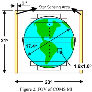
Figure 2. FOV of COMS MI
Figure 2 shows the FOV (Field of View) of the COMS MI (Meteorological Imager). This FOV has an observing area of 21° x 21°. As it is showed at the figure, this FOV has observing area of 1° at both of east and west edge for star sensing.
Then, let’s imagine a situation like figure 3. The figure 3 shows in case of the earth and two stars detected by MI simultaneously. If we put an imaginary inertial coordinates into the sensor’s FOV the result will be figure 4. The FOV of MI can be regarded as two-dimensional plane. Now, the stars on the FOV can be identified by on- board star catalogue and identification algorithm. Then, we can determine the equatorial coordinates in the. So, we can acquire the inertial coordinates of the earth from satellite and the opposite direction is the inertial coordinate vector of satellite. We can use these vectors as the input observing data for the orbit determination of the satellite.
Figure 3. Configuration of Star Sensing 21o 17.4
.… .…
o
23o
1.6x1.6o 21o 17.4
.… .…
o
23o
1.6x1.6o
Star Sensing Area 1 o
Earth
V
γ
3 Figure 4. MI Field of View
2.2 Batch Mode Orbit Determination
In this simulation we use a simple batch mode orbit determination algorithm, which is known as least square method.
3. SIMULATIONS 3.1 Simulation Environments
The initial orbit elements used for a simulation were showed at table 1. The simulation program was prepared using MATLAB in general PC environments. We used two different orbit models to compare the convergence.
One model is same with the simulated data generation orbit and the other one is different orbit model.
Table 1. Initial Orbital Elements Classical Elements
SMA (a) 42164.169637 km
Inclination (i) 0.0002 deg
RAAN (Ω) 335.206455 deg
ARP (ω) 0.0 deg
Eccentricity (e) 0.0001
Mean Anomaly (M) 0.0 deg Cartesian Elements
X 38273.84809 km
Y -17679.76832 km
Z 0.0 km
Vx 1.289487 km/sec
Vy 2.791531 km/sec
Vz 0.001073 km/sec
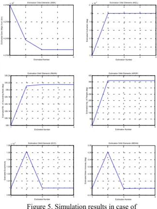
3.2 Simulation Results
Figure 5 and 6 shows the orbit determination simulation results of each orbit model. Figure 5 is the orbit elements determination results in case of the algorithm model is same with the data generation orbit model. And the figure 6 is the different orbit model.
Figure 5. Simulation results in case of same orbit models
Figure 6. Simulation results in case of different orbit models
1 2 3 4 5
0 5 10 15 20 25 30
Estimation Number
Estimated Mean Anomaly (deg)
Estimation Orbit Elements (MEAN)
1 2 3 4 5
0 50 100 150 200 250 300
Estimation Number
Estimated Arg. of Perigee (deg)
Estimation Orbit Elements (ARGP)
1 2 3 4 5
1.5 2 2.5 3x 10⁻⁴
Estimation Number
Estimated Inclination (deg)
Estimation Orbit Elements (INCL)
1 2 3 4 5
-0.01 0 0.01 0.02 0.03 0.04 0.05 0.06
Estimation Number
Estimated Mean Anomaly (deg)
Estimation Orbit Elements (MEAN)
1 2 3 4 5
0 50 100 150 200 250 300 350 400
Estimation Number
Estimated Arg. of Perigee (deg)
Estimation Orbit Elements (ARGP)
1 2 3 4 5
1.5 1.6 1.7 1.8 1.9 2 2.1x 10⁻⁴
Estimation Number
Estimated Inclination (deg)
Estimation Orbit Elements (INCL)
1 2 3 4 5
0.99 1 1.01 1.02 1.03 1.04 1.05 1.06x 10⁻⁴
Estimated Number
Estimated Eccentricity
Estimation Orbit Elements (ECC)
1 2 3 4 5
335.1 335.12 335.14 335.16 335.18 335.2 335.22 335.24
Estimated Number
Estimated RA. of Ascending Node (deg)
Estimation Orbit Elements (RAAN)
1 2 3 4 5
4.2164 4.2165 4.2165 4.2165x 10⁴
Estimated Number
Estimated Semi Major Axis (km)
Estimation Orbit Elements (SMA)
1 2 3 4 5
4 5 6 7 8 9 10 11x 10-5
Estimated Number
Estimated Eccentricity
Estimation Orbit Elements (ECC)
1 2 3 4 5
0 50 100 150 200 250 300 350
Estimated Number
Estimated RA. of Ascending Node (deg)
Estimation Orbit Elements (RAAN)
1 2 3 4 5
4.2162 4.2163 4.2164 4.2164 4.2165 4.2165 4.2165x 10⁴
Estimated Number
Estimated Semi Major Axis (km)
Estimation Orbit Elements (SMA)
4 As it is seen from the result graphs, the convergence is
appeared obviously in both cases. In figure 6, the determination results were somewhat different from the original values. It looks caused by the difference between two models. As the results shows, it can be judged that the orbit determination technique by angle data has a quite possibility.
4. CONCLUSION
As described before, we performed the conceptual study about a feasibility of angle data based orbit determination strategy. And we prepared simulation program for instance of COMS, which is the first geostationary meteorological satellite in Korea. By the simulation results it is confirmed that the angle data based orbit determination technique has quite feasibility.
Surely, this conceptual study needs so much further studies, which should include the calibration and star identification algorithm. So, these related studies will be preceded.
The results of this kind of results will be able to use as a part of autonomous satellite operation system. Also this technique can be used as back-up orbit determination method of ground stations.
Reference
EADS Astrium, 2005. COMS Meteo Imager Technical Description In COMS SDR Data Pack.
Acknowledgements
This research was performed as a part of the development of COMS Geostationary Satellite Development Program, which is funded by the Ministries of Science & Technology, Information and Communications, Ocean Development and Korea Meteorological Agency. Thanks for the research supports.