Naming of Undersea Features in the East Sea*
Jinyong Choi** and Yougrak Kwon***
동해 해저지형의 명명*
최진용**·권영락***
Abstract:At present, 3 names about undersea features in the East Sea - Korean Plateau, Tsushima Basin, Syun-yo Bank - are listed on Gazetteer. Any explanations are not given for registration of these names. Just it seems that the names written on International marine chart(INT 511) were recorded to Gazetteer. Furthermore Tsushima Basin and Syun-yo Bank have no oceanographic, geologic reason and geographical relevance, and the names should be replaced by Ulleung Basin and Isabu Tablemount, respectively, that is deeply related to geographical relevance and genetic origin.
Key Words : undersea feature names, Gazetteer, Ulleung Basin, Isabu Tablemount
요약:현재 동해의 해저지형 가운데 한국대지, 쓰시마분지, 순요퇴 3개의 지명이 해저지명목록집(Gazetteer)에 등재되어 있다.
이들 지명은 지명등재의 근거가 전혀 기록되어 있지 않으며, 단지 국제해도(INT 511)에 표기되어 있는 명칭이 해저지명목 록집에 기록된 것으로 추정된다. 그러나 이 중 쓰시마분지와 순요퇴는 수로학적·지질학적 근거나 지리적인 관련성이 부 족하므로 지리적·성인적 측면에서 관계가 깊은 울릉분지와 이사부해산으로 명칭이 대체되어야 한다.
주요어 : 해저지명, 해저지명목록집, 울릉분지, 이사부해산
* This paper is a revised version of that presented at the 12th International Seminar on the Naming of Seas and East Sea held in Seoul, Korea, October 19-21, 2006.
** Professor, Dept. of Oceanography, Kunsan National University, [email protected]
*** Part time researcher, Korea Institution of Curriculum & Evaluation, [email protected]
1. Introduction
East Sea is the marginal sea bordered by Asian continent to the west and surrounded Japanese Islands to the east. The shape of the East Sea is elongated NE-SW direction with 1,700km S-N direction and 1,100km in E-W direction. It covers 1,088×106km2 in area, and average water depth is 1,361m with max. depth deeper than 4,000m.
It is connected to the Okhotsk Sea through Soya
and Tatar Strait, and to the northwest Pacific Ocean and the East China Sea through Tsugaru and Korea Strait, respectively.
East Sea is important in its geologic characters of typical back-arc basin formed by subduction of Pacific Plate beneath the Asian Continent.
Major geologic features consists of three basins (Japan Basin, Yamato Basin and Ulleung Basin), Yamato Ridge, Korea Plateau and Oki Bank.
East Sea is also important in its geographic significance. 3-4 nations of Korea, Japan, Russia and China are closely connected with the East Sea in political and historic basis.
There are, however, no internationally accepted common terms and names on undersea features until yet. For example, Tsushima Basin and Tsushima Strait are the geographic names used in Japan, but Ulleung Basin and Korea Strait are preferred in Korea (Table 1). Also although Soya Strait and Mamiya Strait are used in Japan, La Perouse Strait and Tatar Strait are used in Russia instead respectively.
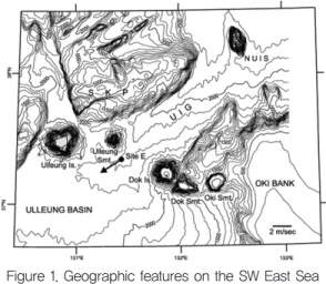
In Korea, there have been many ambiguous situations in terminology and naming on undersea features. Recently, Lee, Bahk and Chough (2004) used the traditional names of geologic features on the southwestern part of the East Sea such as Ulleung Basin and Korea Plateau (Fig.1). They tagged new names for numbers of submarine features of their own purposes such as Ulleung Interplane Gap (UIG), Onnuri Basin, Juksan Seamount chain etc.
Another scientific reports from KIGAM used the terms of Yangyang Basin, Gangwon Ridge, Mukho Basin, Okgae Ridge, Samcheok Ridge and Trough etc (KIGAM, 2004). Most of the names and terms tagged by individual scientists and institutes do not follow international rules of naming undersea features, and thus cannot be accepted officially. This kind of unregulated and
ambiguous naming often causes confusing situations. It is thus necessary to make official name on undersea features, and the procedures should be done as soon as possible.
2. International Standardization of Undersea Feature Names
Internationally, to remedy the conflict situations, guiding rules were adopted by IHO (International Hydrographic Organization) at its 13th Conference (May 1987) and United Nations’
(UNESCO) IOC (Intergovernmental Oceanographic Commission) at its 14th Assembly (March 1987).
Table 1. Comparison of geographic names.
Geographic Feature Korea Japan Russia Basin Ulleung Tsushima
Korea Tsushima
Strait Soya La Pérouse
Mamiya Tatar
Figure 1. Geographic features on the SW East Sea (Lee, Bahk and Chough, 2004)
Figure 2. Geographic names on Korea Plateau (KIGAM, 2004)
The Joint IHO-IOC Guiding Committee operates GEBCO (General Bathymetric Chart of the Ocean) to provide authoritative bathymetric data sets of the world’s oceans. For naming of undersea features, SCUFN (Sub-Committee on Undersea Feature Names) is adopted and publishes Gazetteer of undersea feature names.
SCUFN maintain close liaison with the UN Group of Experts on Geographical Names, and also with international and national authorities such as US BGN (Board on Geographic Names) ACUF (Advisory Committee on Undersea Features).
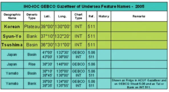
At present, a total of 3 names for undersea features of the East Sea are listed on Gazetteer (Fig.3). International hydrographic chart published by IHO, for example INT-511, has three names on southwestern part of the East Sea near Korean Peninsula - Korean Plateau, Tsushima Basin and Syun-yo Bank. There are, however, no historic records, backgrounds, and remarks for each name (Table 2). Most of the undersea feature names are used just following the old maps without any rationales.
3. History of Regulating Undersea Feature Names in Korea
Since 1990s, Korean Government has realized the importance in the naming of undersea features, and conducted comprehensive hydrographic surveys on Korean Seas. 3-D detailed multibeam data were collected through the surveys together with the magnetic and sub- bottom profilings.
In July 2002, KCMGN (Korea Committee on Marine Geographical Names) was launched, and the working group on naming undersea features was organized in 2005.
After reviewing detailed 3-D bathymetric data, about 90 undersea features were selected as preliminary candidates for naming. Finally 22 features were selected to be named based on geomorphic and geologic significance (Fig.4).
Recently in 2006, 14 undersea features in southwestern part of the East Sea are selected to be named and prepared to submit to SCUFN (Table 3).
Twelve names are new feature names, whereas two names of Ulleung Basin and Isabu Tablemount (Seamount) are already registered on GEBCO Gazetteer as Tsushima Basin and Syun- yo Bank, respectively. These two features are, Figure 3. Position of geographic names on the East
Sea and NW Pacific listed GEBCO Gazetteer (2005)
Table 2. List of selected undersea feature in GEBCO Gazetteer on the East Sea
Figure 4. Selected undersea features officially named in 2005.
Note that 14 features marked by red circle are prepared to submit to SCUFN
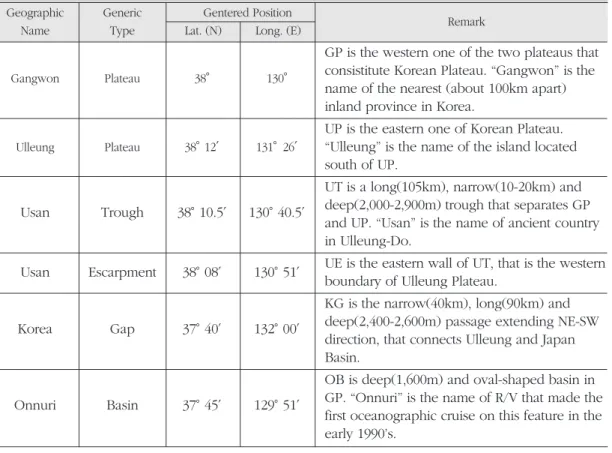
Table 3. List of Undersea Feature Names Prepared to Submit to SCUFN Geographic Generic Gentered Position
Remark
Name Type Lat. (N) Long. (E)
Gangwon Plateau 38° 130°
GP is the western one of the two plateaus that consistitute Korean Plateau. “Gangwon” is the name of the nearest (about 100km apart) inland province in Korea.
Ulleung Plateau 38°12′ 131°26′
UP is the eastern one of Korean Plateau.
“Ulleung” is the name of the island located south of UP.
Usan Trough 38°10.5′ 130°40.5′
UT is a long(105km), narrow(10-20km) and deep(2,000-2,900m) trough that separates GP and UP. “Usan” is the name of ancient country in Ulleung-Do.
Usan Escarpment 38°08′ 130°51′ UE is the eastern wall of UT, that is the western boundary of Ulleung Plateau.
Korea Gap 37°40′ 132°00′
KG is the narrow(40km), long(90km) and deep(2,400-2,600m) passage extending NE-SW direction, that connects Ulleung and Japan Basin.
Onnuri Basin 37°45′ 129°51′
OB is deep(1,600m) and oval-shaped basin in GP. “Onnuri” is the name of R/V that made the first oceanographic cruise on this feature in the early 1990’s.
Geographic Generic Gentered Position
Remark
Name Type Lat. (N) Long. (E)
Seanal Basin 38°14′ 130°25′
SB is also located in GP, but is deeper(2,200m) than OB. “Saenal” is a Korean word meaning a new day or new generation.
UB covers SW part of the East Sea. UB is enclosed by continental margin to the E, W, and S. It is bounded by Korea Plateau and Ulleung Basin to the north. UB should be used instead of “Tsushima Basin”, because of its genetic and geographic characteristics.
Hupo Bank 36°40′ 129°45′
HB is a narrow and long feature extending N-S direction, located on the continental shelf of Korea. The shallowest part of HB is just 5.3m water depth, called “Wangdolcho”. “Hupo” is the name of nearest harbor.
KS is on the GP. It is irregular oval shape in plane view and cone shape in vertical view. It is about 1,000m height and the summit is 868m water depth. “Kiminu” is the name of famous general of Korean navy in the early 15th Centry of “Chosun Dynasty”.
IS is irregularly shaped, that is formed by couples of volcanic eruptions. The height is about 1,000m and the shallowest part is 892m deep. “Igyuwon”(1833-1910) is the famous Korean governor who supported navigations and fisheries in the East Sea.
Anyongbok Seamount 37°30.5′ 131°21.5′
AS is circular-shaped in plane view and cone- shaped in vertical view. The height is 1,600m and shallowest part is 457m deep.
“Anyongbok” is the name of famous navigator who explored Ulleung-Do in 17th centry.
Haeoreum Seamount 38°12.5′ 132°35′
HS is oval-shaped in plane view and cone- shaped in vertical view. It is 1,700m height with shallowest part of 849m deep. “Haeoreum” is the Korean word meaning sunrise.
IS is characterized by flat-topped summit, typical Tablemount. The height is about 1,000m and the shallowest part is 136m deep. IS should be used instead of “Syun-yo Bank”, because of its genetic characteristics. “Isabu” is the name of famous general of Korean Navy who firstly explored Ulleung-Do in 5th century.
Ulleung Basin 37°00′ 130°50′
Kiminu Seamount 37°24′ 130°08′
Igyuwon Seamount 37°33′ 130°27′
Isabu Seamount 37°10′ 132°20′ (Tablemount)
however, fall within the jurisdiction of Korean EEZ and the new proposed names are more appropriate for their genetic characters than the older ones.
4. Ulleung Basin in Lieu of Tsushima Basin
The name of Tsushima Basin in GEBCO Gazetteer is accidentally collected from INT-511 based on the old maps. “Tsushima” is the name of small island located in the Korea Strait far away from the East Sea. The name, therefore, does not have any geographic and generic relations with the basin itself. In this context, the current name of “Tsushima Basin” should be replaced by the new and appropriate one, the
“Ulleung Basin”.
“Ulleung” is the name of the island located at and/or near the basin in the East Sea (Fig.5).
Ulleung-do(island) and Ulleung Basin share the same genetic origin that are closely related with the formation of the East Sea. In recent years, therefore, the name of “Ulleung Basin” is preferred by oceanographers and is more widely used in scientific research papers on geologic and oceanographic field than
“Tsushima Basin”.
5. “Isabu Tablemount” Rather Than
“Syun-yo Bank”
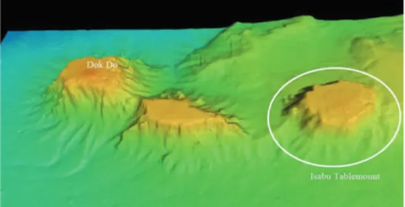
“Isabu Tablemount(Seamount) is the volcanic seamount located on the east of Dok-do(island) (Fig.6). It is dome-shaped with flat-top summit, and the hight reaches about 1,000m. This feature is already listed on GEBCO Gazetteer as “Syun- yo Bank”. The name of “Syun-yo” has no historic records and remarks. The feature itself is not the
“Bank” but the volcanic seamount, and the genetic origin is closely related with the formation of Dok-do and Simhungtaek Seamount.
Simhungtaek Seamount between Dok-do and Isabu Tablemount was not submitted to SCUFN, because it is located within the range of Korea territorial water.
6. Conclusion
The naming on undersea features is necessary on account of academic research, but the names having not appropriate rationale should be replaced by proper ones.
Tsushima is the name of island located in
Figure 5. General bathymetric feature of Ulleung Basin
Figure 6. 3-D morphology of Isabu Tablemount.
Note the location of Dok-do and Shimhungtaek Seamount in between.
Korea Strait far away from Ulleung Basin.
Ulleung-do(island) is, on the other hand, located at near the Ulleung Basin. Furthermore Ulleung island and the basin share the same genetic origin. Therefore, the name of Tsushima should be replaced by the proper one of “Ulleung”.
Syun-yo Tai(bank) is incorrect generic name.
This undersea feature is not bank but seamount(tablemount). Therefore, the name of Syun-yo Tai is modified to appropriate new name of Isabu Tablemount in geologic basis.
References
IHO and IOC, 2005, GEBCO Gazetteer.
KCMGN (Korea Committee on Marine Geographical Names), 2004, The Guideline for Standardization of Marine Geographical Names (in Korean).
Lee, Bahk and Chough, 2004. Late Quaternary
sedimentation in the eastern continental margin of the Korean Peninsula. in Clift, R., Wang, P., Kuhnt, W. and Hayes, D. (eds.), Continent- Ocean Interaction within East Asian Marginal Seas, Geophysical Monograph Series 149, American Geophysical Union. 205-233.
NORI (National Oceanographic Research Institute), 2005, A Survey on Marine Geographical Names in the Middle of East Sea (in Korean).
Correspondence : Jinyong Choi, Dept. of Oceanography, Kunsan National University, Kunsan, Jeollabuk- do 573-701, Korea (e-mail: jinyong@kunsan.
ac.kr, phone 82-63-469-4604)
교신 : 최진용, 전라북도 군산시 대학로 1170, 군산대학교 해양과학대학 해양학과 (이메일 jinyong@ kunsan.
ac.kr, phone 82-63-469-4604)
Received October 20, 2006 Accepted December 20, 2006