IEG 환경지질연구정보센터
6
0
0
전체 글
(2) 박상은 · 김덕진 · 문우일. tidal ranges and vast expanses of intertidal flats. Intertidal flat forms a unique ecosystem, providing the habitat for various species of fauna and flora which play an important role in the essential function of water purification and marine products industry. However, monitoring and mapping of intertidal flats from in situ measurements are severely troublesome work resulting in very limited numbers of observation points. Remote sensing can provide large spatial coverage and nonintrusive measurement over the Earth’ s surface. Thus it is suited for monitoring and mapping surface characteristics of intertidal flats. In particular, microwave remote sensing using synthetic aperture radar (SAR) system has great potential for quantitative monitoring and mapping of intertidal flats. Recently numerous studies using the polarimetric SAR measurements have been conducted to extract information on the surface characteristics (Ulaby and Elachi, 1990; Fung, 1994). However, very few studies were carried out in intertidal areas in spite of their unique environment (van der Wal and Herman, 2005). In this study, a polarimetric airborne SAR measurement has been used to study the radar polarimetric characteristics in the intertidal area on the south coast of the Korea. Theoretical models of microwave scattering from rough surfaces, such as semi-empirical model (Oh, 2004), and Extended Bragg model (Schuler et al., 2002; Hajnsek et al., 2003), were applied to investigate the surface characteristics of intertidal zones.. 2. Methods (1) Empirical Model A semi-empirical polarimetric backscattering model has been introduced for randomly rough bare soil surfaces (Oh, 2004). On the basis of the scatterometer measurements and ground measurements, empirically determined functions for the co- and cross-polarized backscatter ratios were introduced 0 σ HV = 0.11(mV ) 0.7 (cos θ ) 2.2 [1 − exp(− 0.32( ks) 1.8 )]. (1). 0 0 σ HH σ VV = 1 − (θ / 90 o ). (2). 0. 35 mV−0. 65. (. ⋅ exp − 0.4( ks) 1.4. ). 0 0 σ HV σ VV = 0.095(0.13 + sin1.5θ )1.4 {1 − exp(− 1.3(ks )0.9 )}. (3). where mV is the volumetric soil moisture content, s is the surface RMS height, l is the surface correlation length, and θ is the local incidence angle. The model agrees with experimental observations over a wide range of surface geometric and dielectric conditions. (2) Extended Bragg Model Recently, an improvement of the Bragg scattering model for a wider range of roughness conditions has been proposed (Schuler et al., 2002; Hajnsek et al., 2003). The extended Bragg model incorporates both Bragg scatter as well as the depolarizing effects of azimuth slopes. By rotating the Bragg coherency matrix. - 272 -.
(3) A study on microwave scattering characteristics in intertidal flat using polarimetric SAR. about a local orientation angle, the averaged coherency matrix over the azimuthal slope distribution p(ψ ) is given as. [T ] ψ. C 2 A(ψ ) 0 C1 * , 0 = C 2 A(ψ ) 2C 3 B(ψ ) 0 0 2C 3 (1 − B(ψ )) . (4). where C1 =| Rs + RP |2 , C 2 = ( RS + RP )(RS − RP )∗ , C3 = 12 | Rs − RP |2 are the Bragg scattering coefficients, and A(ψ ) and B (ψ ). are averaging of orientation angle distribution.. The coherency matrix terms contain combined Bragg scatter terms occurring on a surface perturbed by a distribution of slope-induced changes in the orientation angle. The polarimetric coherence between the and Right– Right and Left– Left circular polarizations follows as. ρ RRLL =. T22 − T33 = 2 B (ψ ) − 1 , T22 + T33. (5). and depends only on the surface roughness. This is in accordance with the experimental observations reported in Mattia et al., (1997) which established a sensitive relation between. ρ RRLL. and surface roughness. Consequently, the. extended Bragg model is characterized by an inherent separation of roughness and moisture effects allowing an independent estimation of these parameters. The distribution of orientation angles describes the effects of slopes and determining the polarimetric coherence. In practice, two types of distributions functions have been accounted for extended Bragg model, i.e., 1) uniform distribution (Hajnsek et al., 2003; Cloude et al., 1999), and 2) Gaussian distribution (Schuler et al., 2002). Following the uniform distribution, the roughness values can be obtained directly from their anisotropy values by using a linear approximation of the relationship as. ks = 1 − A . Based on the Gaussian distribution, Schuler et al. (2002) provided a theoretical relationship between ρ RRLL and surface roughness parameters as. ρ RRLL = e −16 s / (l 2. 2. sin 2 θ. ).. (6). 3. Study Area The L-band NASA/JPL airborne SAR (AIRSAR) data, which were acquired on the intertidal zone, Yeoja Bay, southern part of Korean Peninsula, during PACRIM-Ⅱ. - 273 -.
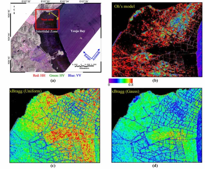
(4) 박상은 · 김덕진 · 문우일. Fig. 1.(a) Study area. Estimated ks values using three different models: (b) empirical model, xBragg model with (c) uniform and (d)Gaussian distribution. Korea campaign on September 30, 2000, were used for this research (Fig. 1). Yeoja Bay is semi-enclosed by Yeosu and Goheung Peninsula in the South Coast of Korea. The surface sediment of Yeoja Bay mainly consists of silty clay. The area is tide-dominated and experiences a semidiurnal with a mean tidal range of about 250cm.. 4. Results L-band fully polarimetric AIRSAR data of Yeoja bay was processed. The polarimetric SAR data was performed the Lee-filtering and geocoded. A specific test site (rectangle on Fig.1(a)) is selected for this study. The intertidal flat is not vegetated, with the exception of several bamboo poles which are implanted artificially into the soil to zone the areas into private properties. Since the dielectric properties of this mud flat can be assumed more or less same in this area, backscattering properties are highly dependent on surface roughness. The intertidal zone of the area is used as cockle production, and the land-use patterns can be characterized by the surface roughness properties. Both of the Oh’ s semi-. - 274 -.
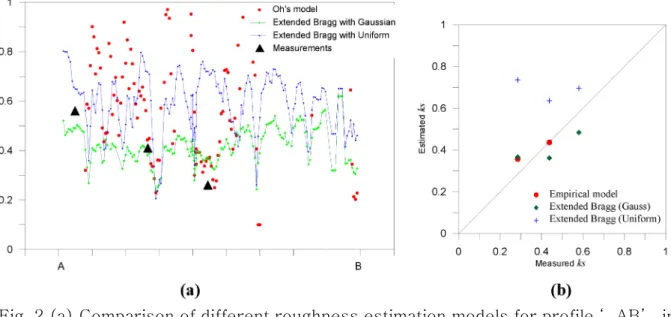
(5) A study on microwave scattering characteristics in intertidal flat using polarimetric SAR. empirical model and extended Bragg models can estimate surface roughness separately from the soil moisture as discussed in previous section. Fig. 1(b)-(d) shows estimated surface roughness values of mud flat area. Since low VV signal increases cross-polarized ratio, Oh model is not valid for some portion of mud flat. However extended Bragg model estimates relatively high roughness values for those of regions that reveal low VV signal and high cross-polarized ratio. We measured the real surface roughness through the field trip using photogrammetric analysis. Fig. 2(a) shows the estimated roughness for profile ' AB' in Fig. 1. The roughness based on the Oh’ s model has higher values in general compare to the extended Bragg roughness estimator. Fig. 2(b) shows comparison between the surface roughness ks estimated by the inversion technique and that measured in situ. The extended Bragg model with anisotropy method overestimates ks values.. Fig. 2.(a) Comparison of different roughness estimation models for profile ‘ AB’ in Fig. 1. (b) Measured and estimated surface roughness.. 5. Conclusion Polarimetric airborne synthetic aperture radar (SAR) data was investigated to study the characteristics of intertidal flat. Surface RMS height can be used as a key parameter which describes the backscattering processes over mud flats. Surface roughness in the intertidal flat was estimated using Oh model and extended Bragg model. Both the Oh’ s semi-empirical model and the extended Bragg model can estimate surface roughness separately from the soil moisture. the extended Bragg model was adequate to investigate the surface geometrical characteristics of intertidal zone. The anisotropy method overestimates the lower roughness values. The circular polarization coherence method gives good agreement with field observation of surface roughness over study sites.. - 275 -.
(6) 박상은 · 김덕진 · 문우일. Acknowledgement This research is partially funded by the Korea Meteorological Administration (KMA), Electronics and Telecommunications Research Institute (ETRI), Korea Ocean Research & Development Institute (KORDI), Korea Institute of S & T Evaluation and Planning (KISTEP), and NSERC of Canada Discovery Grant (A7400) to Wooil M. Moon. The PACRIM-II AIRSAR experiment was funded by the SNU Interdisciplinary Grant, NSERC of Canada (Operating & Equipment Grants) and partially by the Korea Research Foundation Grant (KRF-2000-015-DP0432) and research contract of the Korea Aerospace Research Institute (KARI).. References Cloude, S. R., I. Hajnsek, and K. P. Papathanassiou, An eigenvector method for the extraction of surface parameters in polarimetric SAR, in CEOS- Workshop, Toulouse, France, 1999. Fung, A. K., Microwave Scattering and Emission Models and Their Applications. Norwood, MA: Artech House, 1994. Hajnsek, I., E. Pottier, and S. R. Cloude, Inversion of surface parameters from polarimetric SAR, IEEE Trans. Geosci Remote Sensing, vol. 41, pp. 727– 744, Apr. 2003. Mattia, F., T. Le Toan, J. C. Souyris, G. De Carolis, N. Floury, F. Posa, and G. Pasquariello, The effect of surface roughness on multi-frequency polarimetric SAR data, IEEE Trans. Geosci. Remote Sensing, vol. 35, pp. 954– 966, July 1997. Oh, Y., Quantitative retrieval of soil moisture content and surface roughness from multipolarized radar observations of bare soil surfaces, IEEE Trans. Geosci.. Remote Sensing, vol. 42, pp. 596-601, Mar. 2004. Schuler, D. L., J. S. Lee, D. Kasilingam, and G. Nesti, Surface roughness and slope measurements using polarimetric SAR data, IEEE Trans. Geosci. Remote Sensing, vol. 40, pp 687-698, Mar. 2002. Ulaby, F. T. and Elachi, C., Radar polarimetry for geoscience applications, Artech House, Norwood, MA., 1990. van der Wal, D., P.M.J. Herman, A. Wielemaker-van den Dool, Characterization of surface roughness and sediment texture of intertidal flats using ERS SAR imagery, Remote Sensing of Environment, vol. 98, no. 1, pp. 96-109, 2005.. - 276 -.
(7)
수치
관련 문서
100 lux 조건 하에 동영상 촬영을 진행하 고, 모든 동영상 촬영이 끝난 후 Noldus의 Ethovision(ver. 8.0)으 로 mouse가 open arms에 머문 시간과 mouse가 open
Kim et al.,(2004)은 플라이오메트릭 훈련을 포함한 복합 트레이닝이 정적 및 동적 균형능력에 향상을 나타낸다고 보고하였으며 조원희 와
The Oral health status (such as subjective oral heal th status, toothache) and oral health behaviors (such as tooth brush, or al health examination) were
당뇨의 적정관리 평가지표로는 당화혈색소 검사, 미세단백뇨 검사, 안저 검사 등이 있으며(Armesto et al., 2007; Nicolucci et al., 2006), 이에 따른 기준으로
화학시냅스에서 시냅스전뉴런의 활동전압이 시냅스후 뉴런으로 전도되는 과정. Principles of Neuroscience, Kandel
In this thesis, tracked vehicle's dynamic performance of the two models, single-body model and Multi-body model, were compared through the numerical simulation.. The
Marfaing Marfaing Marfaing Marfaing- -- -Koka A, Devergne O, Gorgone G, et al: Koka A, Devergne O, Gorgone G, et al: Koka A, Devergne O, Gorgone G, et al: Koka A, Devergne O,
Lappas, “Design and Structural Analysis of a Control Moment Gyroscope (CMG) Actuator for CubeSats”, Aerospace, Vol. Cheng et al., “Numerical Simulation of Separation
