DEVELOPMENT OF MTSAT DATA PROCESSING, DISTRIBUTION AND VISUALIZATION SYSTEM ON WWW
Wataru Takeuchi
†, Toshihiro Nemoto
†, Takayuki Kaneko
‡and Yoshifumi Yasuoka
††
Institute of Industrial Science, University of Tokyo
‡
Earthquake Research Institute, University of Tokyo 6-1, Komaba 4-chome, Meguro, Tokyo 153-8505 JAPAN Corresponding author:[email protected] KEY WORDS: HRIT, mtsatgeo, YUV model
ABSTRACT
Abstract: This research focuses on a network based data distribution and visualization system of Multi-functional Tran- port SATellite (MTSAT). Institute of Industrial Science (IIS) and Institute of Earthquake Research Institute (ERI) both at University of Tokyo have been receiving, processing, archiving and distributing of MTSAT imagery with a direct receiving of High Rate Information Transmit (HRIT) since October 2006. A software package, mtsatgeo, is developed including radiometric correction, geometric correction and spatial subset, and they are available on a web-based data distribution and processing service accessed at http://webgms.iis.u-tokyo.ac.jp/.
Keywords: mtsatgeo, YUV model, precise geometric correction
1 INTRODUCTION
1.1 Backgrounds
Multi-purpose Transmission SATellite (MTSAT) is Japanese weather satellite for geosynchronous orbit. MTSAT is a three-axis stabilized spacecraft and carries both a meteoro- logical mission and an aeronautical communications mis- sion. The Japan Meteorological Agency (JMA) contracted for MTSAT as a successor to GMS-5, in cooperation with the Civil Aviation Bureau (CAB), of the Ministry of Trans- port of Japan (JMA, 2003).
Geostationary satellites such as Meteosat, GMS and Geo- stationary Operational Environmental Satellite (GOES) were designed for meteorological applications. As a consequence, the onboard sensors have very low geometric, radiometric and spectral resolution. Despite these characteristics, dur- ing recent years, several studies have used geostationary satellite data for land surface remote sensing application.
In most of them, these data have been used to retrieve geo- physical parameters used as an input for models GMS data and are very effective to detect burned areas in different tropical environments as well (Boschetti, et al., 2003).
MTSAT breaks through limitations of earlier three-axis sta- bilized GEO instruments with significant improvements in many areas, including spatial sampling, radiometric sensi- tivity, calibration and performance around local midnight (Puschell et al., 2003). The process for the automatic de- tection of Landmarks and Earth Edges has been working operationally for many months on MTSAT-1R. The ability to use these data as the basis to determine the satellite or- bit and attitude has also been demonstrated (Milnes, 2006).
In this sense, it is necessary to have a continuous accurate and timely determination of the satellite orbit and attitude in order to perform geometric correction of Earth images acquired by geostationary meteorological satellites.
1.2 Objective
This research focuses on a network based data processing, distribution and visualization of MTSAT data. Data pro- cessing includes radiometric correction, geometric correc- tion and spatial subset, and it is developed as a software package, mtsatgeo.
2 METHODOLOGY
2.1 Data receiving, processing and archiving
MTSAT High Rate Information Transmit (HRIT) data have been received at a direct broadcasting system at Yayoi re- search campus of University of Tokyo since October 2006.
They are transfered to an archiving system at Komaba re- search campus of University of Tokyo in a near-real time fashion. MTSAT HRIT products were calibrated to a top- of-atmosphere (TOA) reflectance or brightness tempera- tures for further processing. A set of processing were car- ried out using a web-based data processing system equipped with a direct broadcasting of MTSAT HRIT
1.
2.2 A package software mtsatgeo
A series of pre-processing includes radiometric correction, precise geometric correction, map projection conversion and spatial subset and they are developed as a package software mtsatgeo freely available at our website along with MTSAT HRIT data. A precise geometric correction is carried out by using a template matching technique with shore lines and digital elevation models(Takeuchi et al.).
An evaluation of it is explained at the latter part of this article. A map projection conversion is applied from Nor- malized Geostationary Projection (NGP) to a plate caree projection (lat-lon system) as shown in Figure 1.
1A web-based MTSAT processing system (http://webgms.iis.u-tokyo.ac.jp/)
2.3 A WWW-based data distribution system
A series of pre-processing and distribution is applied to a WWW-based data distribution system. Figure 2 shows a WWW interface of WebGMS system
2. This system en- ables us to promote the data integration system along with NOAA AVHRR
3, Aqua/Terra MODIS
4and MTSAT HRIT.
A line up of satellite data series are processed and trans- fered to Earthquake Research Institute, University of Tokyo to monitor active volcanic activities over East Asia
5,Na- tional Institute of Informatics to monitor typhoon and flood- ing
6, Center for Remote Sensing, Chiba University, Kochi University for weather forcasting
7.
Figure 1: MTSAT image overlayed with shore lines over Pacific Asian region.
3 RESULTS AND DISCUSSIONS
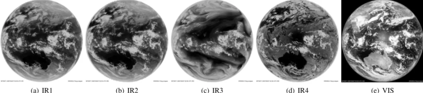
3.1 Pseud-color visualization by color data conversion Figure 3 shows quick look images of visible, thermal in- frared and water vapor channels in gray scale. A pseud- color visualization was carried out on visible channel in 1 kilometer by color data conversion technique to give better visual interpretation.
We followed an idea proposed by (Kittler et al., 1985) to generate a pseud-color image from a gray-scale visible im- age by using a color composite information with the other image sources. In this study, YUV image conversion tech- nique was applied to convert RGB image composite and netpbm software was used to carry it out. It is widely used
2http://webgms.iis.u-tokyo.ac.jp/
3http://webpanda.iis.u-tokyo.ac.jp/
4http://webmodis.iis.u-tokyo.ac.jp/
5http://vrsserv.eri.u-tokyo.ac.jp/REALVOLC/
6http://www.digital-typhoon.org/
7http://weather.is.kochi-u.ac.jp/
Figure 2: WWW interface of WebGMS
(http://webgms.iis.u-tokyo.ac.jp/).
in a color television image format (NTSC) and the relation- ship between YUV and RGB is represented as follows;
Y = 0.299R + 0.587G + 0.114B (1)
U = B − Y (2)
V = R − Y (3)
In equations (2), Y corresponds to a brightness, U to blue and V to red in Mansell color system, respectively. YUV conversion was carried out at in three steps as shown be- low;
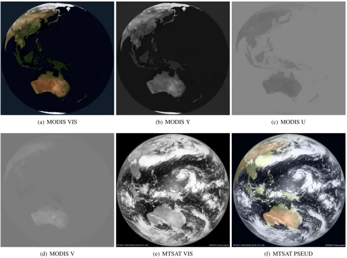
1. A cloud-free MODIS visible images are obtained
8(Figure 4-(a)) and RGB image composite is converted to YUV by using equations (2) (Figure 4 の (b)-(d)).
2. Replace Y component of MODIS (Figure 4-(b)) with a visible image of MTSAT (Figure 4-(e)) then newly generated YUV component is derived.
3. Convert a YUV into RGB by using equations (2) (Fig- ure 4-(f))
Figure 4-(f) shows a pseud-color composite of MTSAT imagery integrated with MODIS YUV color model. An visual interpretation found that a red area is high-colored over desert area such as inner China and central part of Australia, however, over all accuracies seem quite well.
8NASA Blue Marble http://earthobservatory.nasa.gov/
(a) IR1 (b) IR2 (c) IR3 (d) IR4 (e) VIS
Figure 3: Gray scale visualization of MTSAT imagery.
3.2 Precise geometric correction
Figure 5 compares MTSAT subset scene of system correc- tion with that of precise geometric correction overlaid with shore lines. A coverage over 400 ×400 km
2is centered around (32.0N, 88.0E) over Himalaya lake zones with a elevation 4,600 meters high above the sea level.
Figure 5-(a) shows that a sub-image with a system correc- tion has a gap around 12 kilometers, namely 12 pixels in a image, against shore lines in upper left direction in the scene (north west). This is caused by high elevations over the scene. On the other hand, a sub-image with a pre- cise geometric correction in Figure 5-(b) yields has a good overlay with shore lines by visual interpretation, which re- sults in the importance of a geodetic distortion compensa- tion in high altitude area and off-nadir observation.
4 CONCLUDING REMARKS
This research focused on a network based data processing, distribution and visualization of MTSAT data. Data pro- cessing includes radiometric correction, geometric correc- tion and spatial subset, and it was developed as a software package, mtsatgeo. They are available on a web-based data distribution and processing service. A method was proposed to generate a pseud-color image from panchro- matic data by using MODIS true color composite imagery.
As a result, it was found to be very useful for a better vi- sualization interpretation despite its data access limitation on daytime observation only. All of the information related
with this research is available at a http://webgms.iis.u-tokyo.ac.jp/.
ACKNOWLEDGMENT
This study is financially supported by the Japan Society for the Promotion of Science (JSPS) under the research project ”Development of environment and disaster extrac- tion algorithm and monitoring system with MTSAT focus- ing on international dissemination and knowledge transfer (Grant number: 19569002)”. The authors would like to thank JSPS for their support.
REFERENCES
Boschetti, L., P. A. Brivio, J. M. Gregoire, 2003. The use of Meteosat and GMS imagery to detect burned areas in tropical environments. Remote Sens. Environ., 85, 78?91.
Japan Meteorological Agency, 2003. JMA HRIT Mission Specific Implementation, Ver. 1.2.
Kittler, J. and M. J. Duff, 1985. Image Processing System Architectures. John Wiley & Sons, Inc., New York, USA.
Milnes, M., 2006. Orbit/Attitude Determination for MT- SAT through automated Landmark and Earth Edge De- tection. Proceedings of 25th ISTS (International Sympo- sium on Space Technology and Science) and 19th ISSFD (International Symposium on Space Flight Dynamics), Kanazawa, Japan.
Puschell, J. J., H. A. Lowe, J. Jeter, S. Kus, R. Osgood, W. T. Hurt, D. Gilman, D. Rogers, R. Hoelter, A. Kamel, 2003. Japanese Advanced Meteorological Imager (JAMI):
Design, Characterization and Expected On-Orbit Perfor- mance. Proceedings of international TOVS study confer- ence, Sainte Adele, Canada.
Takeuchi ,W. and Y. Yasuoka, 2007. Precise geometric correction of MTSAT imagery. Proceedings of the ACRS 2007, Kuala Lumpur, Malaysia.
Wessel, P., and W. H. F. Smith, 1996. A Global
Self-consistent, Hierarchical, High-resolution Shoreline
Database. J. Geophys. Res., B4(101), 8741-8743.
(a) MODIS VIS (b) MODIS Y (c) MODIS U
(d) MODIS V (e) MTSAT VIS (f) MTSAT PSEUD
Figure 4: Pseud color composite of MTSAT imagery integrated with MODIS YUV color model.
(a) System correction (b) Precise geometric correction