* 본 연구는 2020년 국립생태원 전국자연환경조사 GIS-DB 구축의 일환으로 수행되었고, 2019년에 발행한 “독일 자연환 경조사 관련 제도 및 운영 사례집”을 재구성하였음.
First author:Kim, Nam-Shin, Division of Ecological Survey Research, National Institute of Ecology, Tel : +82-41-950-5856, E-mail: [email protected]
Corresponding author:Jung, Song-Hie, Gwangneung Forest Conservation Center, National Arboretum Tel : +82-31-540-8873, E-mail : [email protected]
Received:7 September, 2020. Revised:25 October, 2020. Accepted:20 October, 2020.
- 99 -
독일 정책 분석을 통한 서식지 생태특성 기반 비오톱 유형 분류 및 조사표 제안*
김남신1)․정성희2)․임치홍3)․최철현3)․차진열4)
1)국립생태원 생태조사연구실 팀장․2)국립수목원 광릉숲보전센터 연구원·
3)국립생태원 생태조사연구실 전임연구원․4)국립생태원 생태조사연구실 실장
The suggestion for Biotope Types and Field Datasheet based on Habitat Ecological Characteristics by German Policy Analysis*
Kim, Nam-Shin1)· Jung, Song-Hie2)· Lim, Chi-Hong3)· Choi, Chul-Hyun4) and Cha, Jin-Yeol5)
1)Division of Ecological Survey Research, National Institute of Ecology,Team Leader,
2)Gwangneung Forest Conservation Center, National Arboretum,Researcher,
3)Division of Ecological Survey Research, National Institute of Ecology,Associate Researcher,
4)Division of Ecological Survey Research, National Institute of Ecology,Associate Researcher.
ABSTRACT
This study aims to propose biotope field datasheet and biotope type classification based on habitat-based by analyzing the German biotope system. The German system began in 1976 and has established a habitat-based national biotope classification system. On the other hand, Korea institutionalized in 2018 to build a classification system based on land use and land cover, which is a classification system that does not fully reflect ecosystem in Korea. Germany operates 44 biotope classification systems and 40 biotope field datasheet. Korea uses a single biotope field datasheet regardless of the biotope type. This classification system may not reflect the characteristics of Korea's biotope ecological habitat. The biotope classification system of Korea was proposed by dividing it into five categories: mountain ecology, freshwater ecology, land ecology, coastal ecology, and development area to reflect ecosystem habitat.
The biotope type was designed as a system of large-classification-middle-small classification and subdivided into medium-classification and subdivided in each biotope system. The major classifications were classified into 44 categories according to the mountainous biotope(11), freshwater biotope(8),
terrestrial biotope (12), coastal biotope(6), and development biotope(7). Unlike Germany, Korea's biotope field datasheet was proposed in five ways according to the classification of major ecosystem types.
The results of this study are expected to contribute to the policy suggestion and the utilization of ecosystem conservation because the biotope classification system is classified to reflect the characteristics of ecosystem habitats.
Key Words:
Biotope, Ecological habitat, Classification, Biotope field datasheet
I. 서 론
생물 군집의 서식공간으로서 비오톱은 생태계 보전관리의 기본 단위이다. 비오톱은 생물과 환 경요인이 결합된 안정상태의 생태적 등질 공간이 다. 비오톱 유형은 비오톱 구성인자의 변화에 영 향을 받을 수 있기 때문에 생태환경 관리와 보존 의 기초단위로 이용된다. 국가 수준의 비오톱 자 연생태계 보존과 관리는 1976년 독일에서 처음 시작되었다. 독일은 비오톱 유형간 생물지리 설 정에 있어, 비오톱 영역들 간 구분과 영역 내 생태 적 균질성을 유지하기 위해 비오톱 유형을 분류 해 왔고(Stoddart, 1992), 비오톱 유형분류, 조사 및 평가 체계 정립과 유럽연합 분류체계에 호환 성을 높이기 위한 표준화 작업을 동시에 추진하 여 왔다(Drachenfels 2012).
한국의 비오톱지도(공식 용어: 도시생태현황 지도)는 시가지 내 생물 서식공간의 분포를 확 인하기 위하여 제도적으로 2017년 11월에 출발 하였지만, 일부 지자체에서는 법제화 이전에 조 사 및 조례를 통해 활용해 왔다.
한국의 비오톱 유형은 토지이용도와 토지피 복도를 근간으로 식생 및 동・식물상 정보를 활 용하여 분류된다(Lee, 1996; Choi, 2008; Choi
et al
., 2008; Choi, 2009). 한국의 비오톱 유형화는 시가화지역의 경우 토지이용 분류를 많이 반영 하고, 산림 등 자연공간의 경우는 식생 등에 대 하여 제한적인 수준에서 생태적 특성을 반영하 고 있다. 한국은 생물서식 기반의 비오톱 분류기준이 명확하지 않은 점과 달리 독일은 서식지 와 생물군집을 근간에 기초한 비오톱 유형화와 분류를 하고 있다는 점에서 차이가 있다(Choi
et al.
, 2007; Oh, 2001).본 연구는 한국의 비오톱 유형화와 조사표를 제시하기 위해 첫째, 비오톱 개념을 정리하고, 독일의 비오톱 유형화 기준을 분석하여 한국에 적용 가능한 분류체계를 제시하는 것을 목적으 로 수행하였다. 한국의 비오톱 유형분류체계 개 선을 위해 독일의 비오톱 유형 분류체계에 대해 검토하는 것을 세부 목표로 한다. 이를 위해 비 오톱 개념을 정리하였고, 독일 비오톱 유형화의 기준을 분석하여 한국의 생태와 환경 특성을 고 려한 비오톱 유형화 방안을 제시하고자 하였다.
II. 선행연구
비오톱 유형화 결과는 Choi
et al
.(2007)에 의 해 독일 연방정부 내 일부 주의 사례가 국내에 소개된 바 있다. Choiet al
.(2008)은 이를 확장 하여 비오톱 유형 분류의 전국적인 적용을 위한 제안을 하였다. 또한, 시흥시를 사례로 독일의 유형화 유형 분류를 시도하였는데, 13개 대분류, 45개 중분류 및 127개 소분류 유형으로 구분하 였다.국내 주요 도시의 비오톱유형의 분류체계를 비교한 Choi(2010)의 논문에서 분류지표의 지역 별 상대적 기준 개발의 필요성을 주장하였지만, 연방정부인 독일의 주와 달리 한국의 지자체는
행정단위별 전문인력이 부족하고, ‘도’ 수준의 관리가 되지 않는 이상, 연방체제와의 근본적인 차이로 상대적인 기준의 개발에 한계가 있다.
환경부는 현재, 도시생태현황지도 작성지침에 서 전국적으로 적용할 수 있는 비오톱유형 분류 체계와 기본 유형목록을 제시하여 중분류까지 유 형을 제시하고, 소분류는 지자체 특성을 고려하 여 자율에 맡기고 있다(Ministry of Environment.
2019b). 독일의 비오톱 유형화는 일부 주에서 유 형이 정립된 이후 국가 차원의 목록 통합과 수정 이 이루어졌다. 독일의 비오톱 유형은 생물세계 비오톱(biotope)과 서식지(habitat)로서 지오톱 (geotope)을 종합한 분류체계를 정립하였기 때문 에 한국의 비오톱 유형화에 참고할 가치가 있다 (Tricart and KiewietdeJonge, 1992).
III. 비오톱 개념
한국에서 비오톱은 20세기 후반(1980~2000) 환경문제가 대두되면서 환경 관리의 필요성에 때문에 제도 및 개념이 도입되었다. 비오톱은 한국에 소개되면서 국문 발음에 따라 ‘비오톱’
그대로 활용되기도 하였다. 시간이 흐름에 따라 적절한 번역의 필요성, 그리고 국가의 생태환경 현실에 적합하도록 원래 의미와 기능을 계승한 소생물권 또는 소생태계와 같은 파생된 의미와 기능들이 활용되어 왔다.
한국의 비오톱 도입과 활용 과정에서 본래 비 오톱의 생물 요소로서 ‘생물과 동·식물의 영향’
이 갖는 의미는 사라지고, 특정 생물군집을 지 칭하는 의미로 전환되었다. 한국에서 비오톱은 학문 및 행정적 측면에서 다양한 의미로 수용되 어 행정 영역(환경부, 비오톱 및 소생태계)으로 들어와 있거나, 기초 개념 정립 및 실용화 준비 (산림청, 산지소생물권)가 이루어지고 있다. 한 편, 기존 비오톱 인식에는 존재하지 않았지만, 환경부의 소생태계 정의에서는 최근 생태환경 변화에 따라 필요성이 높아진 보전생물학적 관
점(생물다양성 및 보전) 및 경관생태학적 관점 (서식지 간 이동성 및 생태계 연속성)의 요소들 이 뚜렷이 강조되고 있다. 한국에서 비오톱 개 념은 비오톱, 생태계 그리고 서식지에 대한 생 태학적 체계에 따라 분류되기 보다는 혼재된 형 태로 도입되었다고 볼 수 있다.
한국은 산지소생물권, 비오톱, 그리고 소생태 계는 비오톱 개념의 도입으로부터 출발했지만, 생물군집과 공간에 관한 개념으로서 현재 작동 하고 있다. 아쉬운 점은, 과학적 체계를 반영한 명확한 개념 정립과 인식이 함께 이루어지지 못 했다는 점이다. 비오톱에 대한 제도적 활용에 대한 요구에도 불구하고 학계의 함의, 비오톱 유형화와 지도제작에 대한 심도있는 학술적 연 구에 대한 뒷받침이 미흡한 실정이다.
행정적 측면 외, 비오톱 또는 그 개념과 기본 원리를 활용하기 위한 필수 단계는 현장 조사를 통한 비오톱 유형의 발굴과 유형화 작업이다. 일 반적으로 비오톱은 한국의 조경학 분야에서 독 일의 ‘정주지역 비오톱’ 조사 기법과 식생군집 연구 기법을 혼합하며 도시 지역 환경 평가 또는 조경 활동에 활발히 적용되었다. 이후 다양한 활 용 의미를 담은 단어인 ‘비오톱’ 이 확산되었다.
그리스 어원의 bios(생명 또는 생물)와 topos (공간)가 합쳐진 독일어의 비오톱은 공간적 경계 를 가지는 특정 생물군집의 서식공간을 의미한 다. 모든 생물은 그들의 생존에 필요한 조건을 갖춘 특정 공간에 서식하고 있으며, 따라서 각각 의 비오톱은 고유한 환경속성에 따라 다른 환경 과 구분될 수 있다(Sukoop and Weiler, 1988;
Leser, 1991).
국내에서는 1990년대 자연환경과 인공환경 사이의 불균형으로 환경문제가 심각해지면서 환경관리와 서식지 보전을 위한 기본 단위로 비 오톱 개념이 이용되었다. 1900년대 독일의 Dahl (1908)이 처음 사용한 이 개념은 한국에 소개되 면서 ‘비오톱’으로 명명되거나 소생물권, 소생 태계 등의 국문 용어로 불리고 있다.
Figure 1. Relation with ecosystem, biotope, biocoenosis (Tricart and KiewietdeJonge, 1992; Drachenfels, 2012)
비오톱은 그 의미에서 서식지(habitat)와 개념 이 유사하지만, 특정한 동・식물 군집이 상호작 용하며 공존하는 균질한 서식 공간인 비오톱과 달리, 서식지는 특정 동・식물 종이 존재하는 자 연환경을 뜻한다. 즉, 비오톱은 여러 종의 집합 인 생물 군집에 기초하는 반면, 서식지는 한 종 의 집단인 개체군을 기준으로 한다(Chepkemoi, 2017).
비오톱과 서식지(habitat)의 개념을 혼용하지 않기 위해 생태계 정의를 참고할 필요가 있다. 생 태계(ecosystem)는 일정한 지역에 사는 생물과 그 생물을 둘러싸고 상호작용하는 물리적 환경의 총체로 정의되며, 이는 크게 생물과 비생물 요소 로 구성된다. 생태계 내 통합적인 카테고리로서 비오톱은 서식 공간의 질을 결정하는 모든 특성 을 포함한다. 생태학적 관점에서 비오톱은 생물 군집(인간을 포함한 생물, biocoenosis)과 물질순 환을 포함한 서식공간의 모든 요소를 뜻한다 (Figure 1). 비오톱은 공간-구조(지형, 식물, 동물, 인위적 구조), 생물(식생, 동물 및 인간 영향) 및 비생물(입지조건) 요소로 구성된다. 비오톱에는 개별 생물종 보다는 생물종에 의한 군집 변화와 생물이 서식공간에 미치는 영향이 비오톱 개념에 서 다뤄진다(Tricart and KiewietdeJonge, 1992;
Drachenfels, 2012).
IV. 독일과 한국의 비오톱 제도 독일의 자연환경보전 제도는 서식지 모니터링 주체와 보호대상 유형을 법으로 조문화하여 독 일 국내 및 유렵연계를 위한 체계를 구축하고 있 다(Federal government BMU. 2019). 독일의 비 오톱 제도 운영 및 관리 체계는 연방정부 환경자 연보전건물핵안전부(The Environment, Nature Conservation and Nuclear Safety;BMU) 및 자연 보호청(Bundesamt für Naturschutz;BfN), 주정부 환경청, 시 환경청 및 조합(Gesellschaft bürgerlichen Rechts; GbR)으로 구성되어 있다 (EU Habitats Directive,2019). 연방정부는 비오 톱의 유럽협력과 유형화, 비오톱 정의, 멸종위기 종평가와 활용 방안을 제시하고, 주환경청은 조 합의 협조를 받아 비오톱 작성 지침, 조사, 지도 작성 등 운영전반에 대한 관리를 하며, 시환경청 은 비오톱지도를 활용한 시민, 개발, 보존과 관 련된 실무역할을 하고 있다. 조합은 주환경청과 시환경청의 비오톱 조사와 지도작성을 지원하는 데, 시환경청에서의 조합의 역할은 시에서 추진 하는 추가조사와 관련된 지도 작성을 돕는다
(BNatschG, 2019; LNatSchG NRW, 2019).
비오톱 모니터링 및 지도 작성 주체 측면에 서, 독일은 연방정부 자연환경보전법(BNatschG) 제6조에 의해 주 정부 단위로 자연환경 모니터 링을 수행하고, 한국은 자연환경보전법 제34조 의2(도시생태현황지도의 작성ㆍ활용)에 따라 특별시·광역시·특별자치시·특별자치도, 인구 30 만이상의 시에서는 도시생태현황지도를 작성하 고 있다. 독일은 주 환경청에서 주 정부 단위로 작성하고 데이터 품질 관리의 책임을 갖고 있으 며, 한국은 시 단위 작성하여 시에서 성과품 전 체에 대한 검수를 수행한 후 환경부(국립생태 원)에 제출하고, 환경부(국립생태원)가 최종 검 토·확인한다(Ministry of Environment. 2019a;
2019b). 독일은 주 환경청에서 비오톱 정보 홈 페이지 운영 및 대국민 공개 담당, 주 정부 하위 의 시청 환경과에서 보호지역 및 법적보호대상 비오톱 관련 개발행위 규제 및 갈등 조정 업무 에 활용한다. 한국은 시청 환경과에서 대국민 공개를 담당하고, 조례 내 개발행위허가 기준에 비오톱이 명시되어 있을 경우, 해당 시청 도시 계획 관련 과에서 개발행위 규제에 대한 근거로 활용하여 갈등 조정 업무를 수행하고 있다.
독일과 한국의 가장 큰 차이점은 작성지침, 예산과 지도작성 및 실무운영에서 차이가 있다.
독일은 주 환경청에서 비오톱 작성 지침을 마련 하고, 예산 및 비오톱 지도를 작성하지만, 한국 은 환경부에서 비오톱 작성 지침을 작성하고, 예산과 지도작성은 지자체에서 담당하고 있다.
비오톱 지도의 실무활용은 독일과 한국 모두지 자체가 담당한다.
독일은 국가 전역을 대상으로 하며, 서식지 유형을 분류하고 비오톱 생물 모니터링을 수행 하지만, 한국은 지자체 도시지역에 대한 생물상 과 비오톱 조사를 수행하고 있다. 독일은 다양 한 서식지 요인(비생물환경, 생물환경)을 기반 으로 비오톱 유형을 구분하며, 비오톱 유형의 생태적 특성, 기반암, 식생유형, 종 특성, 식생유
형, 토지이용 등 다양한 서식지 요인을 종합적 으로 반영할 수 있게 되어 있다(Sukopp and Weiler, 1988). 반면에 한국은 주로 토지이용 유 형과 토지피복에 의한 자연성에 따라 구분하고 있다.
V. 독일 비오톱 유형화 체계 독일 연방정부는 비오톱 유형에 따라 보호지 역을 관리하기 위해 독일 전역의 비오톱 유형을 분류하고 있다(Finck
et al.
, 2017). 또한 비오톱 유형 변화에 따른 서식지 관리를 위해 주요 유 형별 서식지 요인 분석 결과를 BfN(2017)에서 제시하고 있다.1. 비오톱 유형화
독일 연방정부 자연보호청(BfN)은 독일 전역 의 비오톱유형을 대분류-중분류-소분류의 체계 로 분류(Riecken
et al
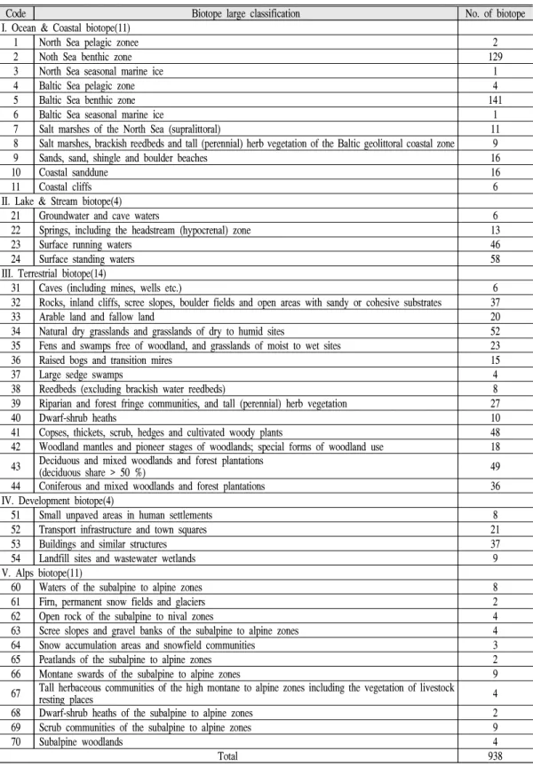
., 2003)하고 있다. 독일 비 오톱 유형은 유형내 생태적 특징이 균질성을 갖 도록 생태적 등질지역으로 구분하여 계층적인 분류체계를 갖도록 구분하였다(Illies and Boto- saneanu, 1963). 독일은 나라 전체의 비오톱유형 목록을 작성하였으며, 2017년 3차 개정안을 발 간하였다(Ministry of Environment and National Institue of Ecology, 2019).국가적인 스케일에서 독일 비오톱 유형은 자 연생태계를 대표하는 5 가지(해양 및 해안(1~
11), 호수 및 하천(21~24), 육상(31~44), 개발지 (51~54), 알프스(61~70)) 비오톱으로 구분하고, 각각의 하부단위에 따라 44개 대분류 및 938개 소분류 단위로 분류하여 분류체계와 코드로 구 성하였다(Table 1). 개발지 비오톱은 4개의 대분 류와 하부의 75개 세분류로 구분하였으며 인간 정주 영역을 제외하면 863개 비오톱이 된다. 주 요 특징은 대분류에서는 서식지 근간인 지오톱 과 지질로 분류되는 특징이 있고, 중분류는 서식 지와 생활형 그리고 소분류에서는 생물군집 및
Code Biotope large classification No. of biotope I. Ocean & Coastal biotope(11)
1 North Sea pelagic zonee 2
2 Noth Sea benthic zone 129
3 North Sea seasonal marine ice 1
4 Baltic Sea pelagic zone 4
5 Baltic Sea benthic zone 141
6 Baltic Sea seasonal marine ice 1
7 Salt marshes of the North Sea (supralittoral) 11
8 Salt marshes, brackish reedbeds and tall (perennial) herb vegetation of the Baltic geolittoral coastal zone 9
9 Sands, sand, shingle and boulder beaches 16
10 Coastal sanddune 16
11 Coastal cliffs 6
II. Lake & Stream biotope(4)
21 Groundwater and cave waters 6
22 Springs, including the headstream (hypocrenal) zone 13
23 Surface running waters 46
24 Surface standing waters 58
III. Terrestrial biotope(14)
31 Caves (including mines, wells etc.) 6
32 Rocks, inland cliffs, scree slopes, boulder fields and open areas with sandy or cohesive substrates 37
33 Arable land and fallow land 20
34 Natural dry grasslands and grasslands of dry to humid sites 52
35 Fens and swamps free of woodland, and grasslands of moist to wet sites 23
36 Raised bogs and transition mires 15
37 Large sedge swamps 4
38 Reedbeds (excluding brackish water reedbeds) 8
39 Riparian and forest fringe communities, and tall (perennial) herb vegetation 27
40 Dwarf-shrub heaths 10
41 Copses, thickets, scrub, hedges and cultivated woody plants 48
42 Woodland mantles and pioneer stages of woodlands; special forms of woodland use 18 43 Deciduous and mixed woodlands and forest plantations
(deciduous share > 50 %) 49
44 Coniferous and mixed woodlands and forest plantations 36
IV. Development biotope(4)
51 Small unpaved areas in human settlements 8
52 Transport infrastructure and town squares 21
53 Buildings and similar structures 37
54 Landfill sites and wastewater wetlands 9
V. Alps biotope(11)
60 Waters of the subalpine to alpine zones 8
61 Firn, permanent snow fields and glaciers 2
62 Open rock of the subalpine to nival zones 4
63 Scree slopes and gravel banks of the subalpine to alpine zones 4
64 Snow accumulation areas and snowfield communities 3
65 Peatlands of the subalpine to alpine zones 2
66 Montane swards of the subalpine to alpine zones 9
67 Tall herbaceous communities of the high montane to alpine zones including the vegetation of livestock
resting places 4
68 Dwarf-shrub heaths of the subalpine to alpine zones 2
69 Scrub communities of the subalpine to alpine zones 9
70 Subalpine woodlands 4
Total 938
Table 1. Biotope classification and list
Divide Subdivide Criteria(habitats) III. Terrestrial biotope
Large category 34. dry humid grassland Humidity, vagetation
Middle category 34.01. dry humid grassland-dry grassland Humidity, vagetation, flora
Small category 34.01.01 dry humid grassland-carbonate rock Humidity, vagetation, flora, bedrock 34.01.01.01 dry humid grassland-carbonate rock-sub the
mediterranean Humidity, vagetation, flora, bedrock,
region IV. Development biotope
Large category 52. Traffic facility and plaza Landuse types
Middle category 52.01. Traffic facility and plaza-pavedroad-over two-lane road,
highway, landing strip Landuse types, permeability
Small category 52.01.01 Traffic facility and plaza-pavedroad-over two-lane road,
highway, landing strip-glu use Landuse types, permeability, material V. Alps biotope
Large category 60. Subalpine-high mountain water zone Elevation, hydrology Middle category 60.01 Subalpine-high mountain water zone-spring Elevation, hydrology, stream Small category 60.01.01 Subalpine-high mountain water zone-spring-ground water
and bog spring Elevation, hydrology, stream
Table 2. Classification example of Germany biotope
Divide Subdivide Criteria(habitats)
I. City biotpe
Large category 01. Residential area Landuse types
Middle category 01.01. Detached house Landuse types
Large category 04. Public land Landuse types
Middle category 04.01. Educational institution Landuse types
Large category 05. Manufacturing area Landuse types
Middle category 05.01. Big scale factory Dimension
II. Green biotpe
Large category 09. Stream Naturality
Middle category 09.01. Natural stream Naturality
Large category 12. Forest Naturality
Middle category 12.01. Natural forest Naturality
Large category 13. grassland Naturality
Middle category 13.02. Artificial grassland Artificiality
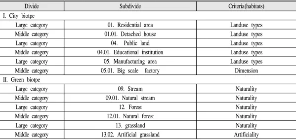
Table 3. Classification example of Korea biotope
특정 동・식물단위로 구분되고 있다(Table 2).
한국 비오톱 유형은 토지이용 분류를 따르고 있어 서식지와 생물군집의 특성을 충분히 반영 하고 있지 못하고 있다(Table 3). 다만, 독일은 개발지 비오톱의 분류 기준으로 토지이용 유형 을 적용하고 있다.
2. 비오톱 조사표
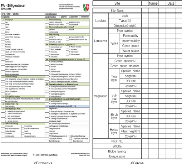
독일은 비오톱의 생태적 특성과 변화를 반영 한 비오톱 유형별 조사표 양식을 표준화하여 비 비오톱조사와 생물조사가 이루어진다. 한국은 분류군별 생물조사표와 비오톱별 조사표가 다 른 양식으로 사용하기 때문에 단순하다.
독일의 주 정부(노르트라인-베스트팔렌주 사 례)는 비오톱 유형 조사체계 확립에 따라 40가
Site Name Date Site Num.
Landuse
code Types(%) Dimension(height)
Landcover
Type symbol Types
Permeability Impermeability
Green space Water space
Vegetation
Type symbol Green space(%) Green space structure
Treelayer
Species Name height(m)
DBH(m) Cover(%)
Subtree layer
Species Name height(m)
DBH(m) Cover(%) Shrub
layer
Species Name DBH(m) Cover(%) Herbal
layer
Species Name Plant height(m) Cover(%) Phot No.
Wildlife Biotpe latency
Unique point
<Germany> <Korea>
Table 4. Biotope field datasheet of Germany and Korea
지 조사표에 따라 비오톱 모니터링을 수행하고 있다(Table 4). 이에 반에 한국은 8개 분류군 조 사표와 1개의 비오톱 조사표로 구성되며, 조사 표는 비오톱 유형 전체를 대상으로 동일하게 적 용한다. 한국은 비오톱 조사 시 토지이용 및 피 복, 현존식생, 야생동물, 대표·우수비오톱 잠재 성에 대하여 조사한다(Ra,1999; Ministry of Environment, 2019b).
독일의 조사항목은 조사자간의 해석의 차이 를 최소화하기 위해 선택형과 기입형으로 구분 하여 비오톱 유형 별 식물 목록을 야장에 제시 하지만, 한국은 조사표 내 모든 항목에 대해 조 사자 자율 기재하도록 되어 있다.
3. 비오톱 유형별 서식지 요인 분석
독일 비오톱 유형은 생물서식지 면적과 보전 에 높은 가치를 두고 있다. 5개의 비오톱 대분류 목록에 대하여 평가한 결과는 Figure 2와 같다.
해양 및 해안 비오톱은 지형이 서식지로서 높은 비중을 차지하고, 다음으로 동물상과 생활형이 서식지에 미치는 영향으로 분석되었다. 호수 및 하천 비오톱은 하천유형과 수문학적 요인이 서 식지에 미치는 영향이 큰 것으로 나타났다. 육 상비오톱은 식생이 주요 서식지 요인로 작용하 고, 알프스 비오톱은 식생과 고도 인자가 차지 하는 비중이 높았다. 개발지 비오톱은 토지이용 유형이 영향이 큰 것으로 나타났다.
Figure 2. Habitats ratio by biotope types of Germany.
한국의 비오톱 서식지 평가는 토지이용과 토 지피복의 유형을 따르고 있어 비오톱 서식지 영 향을 미치는 주요 인자분석에 한계가 있다. 비 오톱 분류체계에 대한 학문적 검토를 통한 유형 분류와 유형별 영향인자를 분석하는 것이 비오 톱 유형별 관리와 보존 체계 정립에 필요하다.
VI. 비오톱 유형분류 제안
비오톱 유형분류는 생태계 구성의 근간이 되
는 생물군집과 서식지가 포함되어야 한다. 이를 위해 지오톱과 생물군집 공간을 구성하는 생태 적 등질지역(ecotope, 이하 생태지역)으로서 비 오톱 유형에 대한 분류체계를 제안 하고자 한다 (Tricart and KiewietdeJonge, 1992). 생태지역 기반 비오톱 유형 분류는 지형과 기반암, 종 특 성, 식생유형, 토지이용 및 피복 등 다양한 서식 지 요인들을 적용할 수 있다.
생물은 무생물기반 생물권을 중심 지표공간 단위 생태지역에서 서식한다. 생태지역은 지형
ecosystem Code Large classification Criteria I. Mountain Biotope(11)
Mountain ecosystem
1 Mountain grassland Landform, Elevation, Vegetation, Biota
2 Mountain shrub layer Landform, Elevation, Vegetation, Biota 3 Mountain ridge tree layer Landform, Elevation, Vegetation, Biota 4 Mountain valley tree layer Landform, Elevation, Vegetation, Biota 5 Subalpine tree layer Landform, Elevation, Vegetation, Biota
6 Mountain Stony zone Landform, Bedrock, Vegetation, Biota
7 Wetland and bog Landform, Vegetation, Biota
8 Unique rocky Landform, Bedrock, Vegetation, Biota
9 Mountain cliff Landform, Bedrock, Vegetation, Biota
10 Mountain basin Landform, Bedrock, Vegetation, Biota, Landuse
11 Mountain flat Landform, Bedrock, Biota
Ⅱ. Freshwater Biotope(8)
Freshwater ecosystem
20 Mountain stream Sttream type, vegetation, Biota
21 Hilly area stream Sttream type, vegetation, Biota
22 Plain area stream Sttream type, vegetation, Biota
23 Riparian Sttream type, vegetation, Biota
24 Lake Sttream type, vegetation, Biota
25 Lagoon Sttream type, vegetation, Biota
26 Groundwater Sttream type, Bedrock, vegetation, Biota
27 Spring Sttream type, vegetation, Biota
Ⅲ. Terrestrial biotope(12)
Terrestrial ecosystem
30 Woodland Landform, vegetation, Biota
31 Artificial forestation vegetation, Biota
32 Shrub land vegetation, Biota
33 Herbal land vegetation, Biota
34 Natural bare land vegetation, Biota
35 Gentleslope Landform, vegetation, Biota, Landuse
36 Hilly basin Landform, vegetation, Biota, Landuse
37 Forest edge Landform, vegetation, Biota, Landuse
38 Windhole Landform, vegetation, Biota,
39 Stony and sand zone Landform, Biota
40 Bedrock landform Landform, Biota, Landuse
41 Arable land and fallow Biota, Landuse
Ⅳ. Coastal biotope(6)
Coastal ecosystem
50 Tidal flat Landform, Biota
51 Sand beach Landform, Sediments, Vegetation, Biota
52 Sanddune Landform, Sediments, Vegetation, Biota
53 Wave-cut terrace Landform, Bedrock, Vegetation, Biota
54 Wetland Landform, Location, Vegetation, Biota
55 Reclaimed land Landform, Vegetation, Biota, Landuse
Ⅴ. Development biotope(7)
Development ecosystem
60 Residential area Landuse, Landcover, Permeability
61 Traffic facility Landuse, Landcover, Permeability
62 Factory Landuse, Landcover, Permeability
63 Commercial area Landuse, Landcover, Permeability
64 Yard and sewage plant Landuse
65 Green area Landuse, biota
66 Artifical bedland Landuse
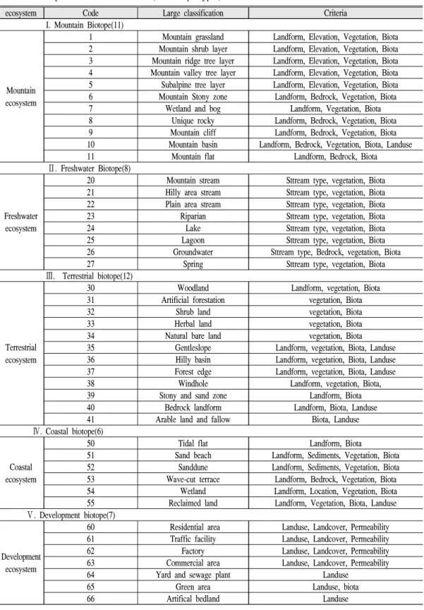
Table 5. Biotope classification of Korea(44 biotope types)
Ⅰ. Mountain biotope
Large category 5. Subalpine tree layer landform, elevation, vegetation
Middle category 5.01 Subalpine tree layer-needleleaf tree landform, elevation, vegetation Small category 5.01.01 Subalpine tree layer-needleleaf tree-abies koreana dominant sp vegetation, biota
5.01.02 Subalpine tree layer-needleleaf tree-Abies nephrolepis dominant sp vegetation, biota 5.01.03 Subalpine tree layer-needleleaf tree-spruce dominant sp vegetation, biota Table 6. Example of each biotope
Biotope type: 5.01.01 Code : 1 ~ 11 X Biotope Values
Ⅰ Ⅲ Ⅴ
Coordinate Longitude: Latitude:
Ⅱ Ⅳ ETC
X Boundary
Identified Changed N e w
drawing X Disturbance(disease, exotic species)
Address
> 1 % ≦1 % Non
X Vegetation type
X Habitat
Needleleaf Mixed
Conservation Partially change
Broadleaf
Little change Damage
X Vegetation by Climate
Boreal Temperate XX Fauna Type
Bird Mamal
Subtropical Tropical Amphibian Reptile
XX Growth group(cover % ≧100% ) XX Fauna growth
Egg Young
% Open forest
Adult
% Smallwood(DBH 7~14cm)
% Middlewood(DBH 14~38cm) XX Fauna habitat
% Seedling(DBH below 7cm)
% Shrub Fecal Cave
% Largewood(DBH 38~50cm) Nest Tree hole
% Largewood(DBH 50~80cm) Sand and soil Aquatic plant
% Largewood(DBH80~100cm) X Fauna type
% Largewood(DBBH over 100cm) Endemic Seasonal
X Vegetation structure(cover over 30% ) X Elevation(m)
Single layer 300-500 Slope and summit
Double layer 500-1,000 Piedmont and summit
Over triplex layer 1,000-1,950 subalpine and summit
X Forest structure type X Landcover
Even-aged Selection Nature Artificial
Selective cutting Coppice II Protection Area
FM/CoC Grazing National
preservation area
World natural heritage X Management type
Economy Managed
zone Historical area
Coppice and Shrub Large scape tree trimming
!! Endangered or Endemic species/climate change /Disturbance etc
Virgin
Write records Non economy
X The others use
Grazing grassland Campsite
leisure Non use
X = Requirement check(single item), XX = Requirement check(plural items), !! all item check Table 7. Biotope field datasheet of Korea biotope: Mountain biotope
No. Herb cover Shrub cover (sub)tree cover Fauna Bird individual(egg, young)) 1
2 3
Endangered and endemic species ※ mark
Table 8. Table lists of biota survey: Mountain biotope species list
공간인 지오톱과 생물공간인 비오톱으로 구성 되어 있다. 지오톱은 지형, 토양, 수문기상이 주 요 구성인자이고, 비오톱은 동물과 식물로 구성 된 소규모 생물권이다. 무생물기반 공간단위 지 오톱은 기상, 수문, 토양이 풍화, 침식, 운반에 기여하여 지형경관을 만들기 때문에 지형이 지 오톱에서 가장 큰 비중을 차지한다. 생물 서식 지로써 지형기반 지오톱과 생물권 비오톱 공간 을 포함하고 있는 생태지역 분류에 기초한 비오 톱 유형분류를 제안하고자 하였다.
독일에서 비오톱 분류에 적용하는 생활형(life form)은 넓은 범위에서 환경 조건에 적응된 형 태적, 생활 양식적 특징을 의미하나, 좁은 범위 에서는 겨울눈의 위치에 구분되는 식물의 생활 특징(라운키에르분류, 지상-지표-지중-수생 1년 생 등)을 의미한다. 한국과 같이 기후환경이 다 양한 환경에 생활형의 기준에 따라 비오톱 분류 체계를 적용한다면 기준에 대한 논란의 소지가 있다.
따라서, 지형, 고도, 식생, 식물상, 토지이용 등을 고려하여 대분류에서는 지형공간단위 지 오톱의 거시적 서식지 환경에 따라 분류하고, 중분류는 서식지 기준에 의한 기후대별 식생대 환경으로 좁혀가며, 소분류에서는 식물군락(침 엽수, 활엽수 등)의 생물 수준(우점군락, 종)으 로 분류체계가 필요하다.
이러한 개념적 틀에 따라 한국의 비오톱 분류 체계는 산지생태, 담수생태, 육상생태, 연안생 태, 개발지의 5가지로 구분하였다. 5가지 분류 에 따라 대분류는 산지 비오톱(11), 담수 비오톱 (8), 육상 비오톱(12), 연안 비오톱(6), 개발지 비 오톱(7)으로 구분하였다. 대분류는 44가지 분류
를 제안하였다(Table 5). 중분류와 세분류는 각 비오톱 체계안에서 군집 수준으로 세분화 될 수 있도록 설계하였다(Table 6).
독일의 비오톱 조사표는 40 가지 유형에 따라 분류하고 있지만, 한국의 생태환경이 독일과는 지형 및 생태계가 차이가 있어 대분류 단위로 조 사표를 구분하여 5 가지로 조사표를 제안하고자 하였다. 한국의 비오톱 조사표는 Table 7 및 생물 조사 목록표는 Table 8과 같이 제안하였다.
VII. 결 론
독일은 지표공간의 생태적 가치를 유형으로 나누고, 그에 대한 가치를 평가 함으로써 도시 와 자연지역에 대한 친환경적인 국토공간계획 을 체계적으로 수립하였다. 한국의 도시생태현 황지도 제도는 아직은 초기 단계이기 때문에 연 구와 지자체 활용을 위해 점차적으로 보완과 개 선이 필요하다. 현행 제도하에 비오톱 유형은 생태계의 구조와 서식지 특성을 충분히 반영하 지 못하는 체계이며, 현장 조사에 필요한 조사 표도 토지이용과 토지피복 위주의 조사체계로 되어 있다.
이를 개선하기 위해 생태지역 기반 서식지 생 태특성을 반영한 한국의 비오톱 유형분류와 조 사표를 제안하고자 하였다. 비오톱 분류는 생태 계 구성의 기반이 되는 생물군집과 서식지, 그 리고 이들이 생태지역을 구성할 수 있도록 지오 톱과 비오톱 기반의 분류체계를 제안하였다.
생태지역 기반에 의한 한국의 비오톱 분류체 계는 산지생태, 담수생태, 육상생태, 연안생태, 개발지의 5가지로 구분하였고, 5가지 분류에 따
라 대분류는 산지 비오톱(11), 담수 비오톱(8),육 상 비오톱(12), 연안 비오톱(6), 개발지 비오톱 (7)로 구분하여 44가지 대분류 비오톱 유형으로 분류하였으며, 중분류와 세분류는 군집수준에 따라 세분화 될 수 있도록 제안하고자 하였고, 5 가지 비오톱 유형별 조사표를 제안하였다.
마지막으로 본 연구에서의 제안은 한국의 비 오톱 분류, 유형화와 조사에 대한 체계적이고 학문적인 논의를 통해 도시지역의 자연환경 보 존과 관리를 위한 도시생태현황지도 제도 개선 에 활용될 수 있을 것으로 기대한다.
References
BNatschG.2019. https://www.gesetze-im-internet.de/
bnatschg_2009/
ChepKemoi J. 2017. What Is The Difference Between A Biotope And A Habitat? https://www.
worldatlas.com/articles/what-is-the-difference-b etween-a-biotope-and-a-habitat.html.
Choi IK and Lee EH. 2007. A study on the classification of biotope type in Germany.
Journal of the Korean Institute of Landscape Architecture.35(5): 73-81.
Choi IK·Ahn GY and Lee EH. 2007. A comparative study of biotope mapping between Korea and Germany. Korean Journal of Environment and Ecology.21(6): 565-575.
Choi IK·Oh CH and Lee EH. 2008. The suggestion for classification of biotope type for nationwide application. Korean Journal of Environment and Ecology.22(6): 666-679.
Choi JW. 2010. Comparisons of classification system of biotope type in major Korean cities. Korean Journal of Environment and Ecology. 24(1):
78-86.
Choi JW.2009. Development of classification and evaluation process of biotope type by suitable
regional characteristics in Seoul metropolitan area, Korea.Procceding Korean Society of Environment and Ecology. 1: 138-141.
Choi SH. 2008. Biotope mapping and evaluation in Gangseo-Gu of Busan metropolitan city. The Journal of the Korean Association of Geographic Information Studies. 11(3); 92-106.
Drachenfels O.2012.Biotoptypen als erfassungs-und bewertungseinheiten von naturschutz und landschaftsplanung. Vorschläge für eine notwendige Standardisierung. Natur und Landschaft, 44, 357-363.
EU Habitats Directive.2019. https://ec.europa.eu/
e n v i r o n m e n t / n a t u r e / l e g i s l a t i o n / habitatsdirective/index_en.htm
Federal government BMU.2017.https://www. bfn.de/
Land
Finck P・Heinze S・Raths U・Riecken U ・ Ssymank. A. 2017. Rote liste der gefährdeten biotoptypen Deutschlands:
dritte fortgeschriebene fassung. Bundesamt für Naturschutz.
Illies J and Botosaneanu L.1963. Problèmes et méthodes de la classification et de la zonation écologique des eaux courantes, considerées surtout du point de vue faunistique: Avec 18 figures dans le texte et en supplément.
Internationale Vereinigung für Theoretische und Angewandte Limnologie: Mitteilungen. 12(1):
1-57.
Lee MC. 1996. A conceptual study of biotope mapping in the city. Journal of Korea Planning Association. 31(6): 197-211.
Leser H. 1991. Landscape ecologie. UTB 521, Eugen UlmerGmbh & Co., Stuttgart.
LNatSchG NRW. 2019.https://recht.nrw.de/lmi/ owa/
br_text_anzeigen?v_id=112005012010 5539311 Ministry of Environment. 2019a. The Natural
Environment Conservation Act.
Ministry of Environment. 2019b. Guidelines for preparing urban ecological status maps.
Ministry of Environment and National Institue of Ecology. 2019. A Case Study on the System and Operation of the Natural Environment Survey in Germany.
Nordrhein-Westfalen. 2019. http://methoden.
naturschutzinformationen.nrw.de/methoden/
de/einleitung
Oh CH. 2001. Application of biotope map for management of Seoul urban ecosystem, Master's degree, University of Seoul.
Ra JH. 1999. A study on the urban biotope classification and analysis. Korean Journal of Environment and Ecology. 13(2): 129-142.
Riecken, U., Finck, P., Raths, U., Schröder, E., and Ssymank, A. 2003. Standard-Biotoptypenliste für Deutschland. Bundesamt für Naturschutz.
Stoddart, D.R., 1992. Biogeography of the Tropical Pacific. Pacific Science, 46(2): 276-293.
Sukopp H and Weiler S. 1988. Biotop mapping and nature conservation strategies in urban areas of the Federal Republic of Germany. Landscape Urban Plann. 15: 39-58.
Tricart J and KiewietdeJonge C. 1992. Ecogeography and rural management - a contribution to the international geosphere-biosphere programme;
John Wiley & Sons, 1992.