위성영상기반 전자주제도 작성 및 관리시스템 개발
- 산림행정업무지원서비스를 사례연구로 - 조 명 희1 ・ 조 윤 원2※
Developing the Satellite Image based
e-Thematic Construction and Management System
-Case Study of Supporting Forest Administrative Service- Myung-Hee JO1 ・ Yun-Won JO2※
요 약
최근 전자지도 제작의 기술적 발전과 국가기본지리정보 성공적인 구축은 우리나라 지리정보의 현황을 전산화 하고 과학적인 국토관리의 기반이 되고 있다. 하지만, 우리 생활 주변의 다양하고 세부적인 지리정보를 처리 및 갱신, 관리과정에는 여전히 미약한 점이 많으며 관공서에서는 아직 까지도 세부적인 지리정보관리를 종이지형도 또는 약도 기반의 관리카드 작성 방법에 의존하 고 있다.
본 연구에서는 최신의 공간정보기술인 GIS, GPS, 위성영상 기술을 통합하여 산림 관공서의 업무 별 지리정보 관리를 사용자 중심의 도면정보로 제작하고, 구축된 GIS DB를 직접 조작, 분석, 출력 가능한 “정밀 전자주제도 작성 및 관리시스템 개발”을 개발하였다.
이를 위한 사례연구로는 제주도 지역의 고해상 위성영상을 이용하여 산림관련 종이 지도 형태의 공간자료를 위치 정확도가 높은 래스터와 벡터 형식의 전산화파일로 전환하고 이를 이용하여 실무 위주의 다양한 주제도 구축을 쉽고 간편하게 하였다. 아울러 공간정보와 속성정보 통합, GPS 현장 데이터의 관리, 멀티미디어정보와의 연동 등의 기능을 통하여 실무자들의 효율적인 산림행정 업무 지원을 위한 e-mapping component를 개발하였다.
향후 본 시스템에서 개발된 전자주제도 제작 및 관리기법은 다양한 형태의 업무지원 및 의사결 정을 위한 유사 응용시스템 개발에 요소기술로 사용가능하리라 기대된다.
주요어 : 전자주제도 작성 및 관리시스템, GIS, GPS, 위성영상, 산림
ABSTRACT
Recently the dramatical development of domestic spatial information technology and the successful construction of Korea NGIS(Nation Geographic Information System) have been the foundation of the
2005년 11월 22일 접수 Received on November 22, 2005 / 2006년 3월 22일 심사완료 Accepted on March 22, 2006 1 경일대학교 건설정보공학과, Department of Construction & Geoinformatics, Kyungil University
2 (주)지오씨엔아이 공간정보기술연구소 Spatial Information Technology Institute, Geo C&I Co., Ltd
※ 연락저자 E-mail: [email protected]
INTRODUCTION
In recent years, the technological advances of spatial information have changed the way geographic analyses are simply done on paper maps. Also, these are approaching toward users more various interface and effective way dramatically and serve more dynamic information then simple static data(Jo, 2005).
In addition, with the advent of today's high-resolution images, beginning with the 1999 launch IKONOS satellite, the spatial data of the highest quality is now available throughout the world. Also, the analyzed image and information derived from it can then be seamlessly brought into a GIS as part of the DSS(Jo, 2005).
Therefore, when the high-resolution satellite image is combined with the various GIS graphic data and attribute data, powerful monitoring, predicting, modeling and analyzing our real world could be performed more easily and embedded under the various systems more effectively.
In this study, the satellite image based high accurate e-thematic construction and management system, integrating current high-resolution images and up-to-date GIS technologies, shows its practical approach with integrated other spatial data type for the construction of forest thematic maps.
Moreover, it shows that how the application system by integrating high-resolution image Moreover, this system plays the role of DSS(Decision Supporting System) for forest administrative affairs by integrating the attribute data, managing the GPS data and linking the multimedia data. For this, the additional main objective of this study was acquired powerful GIS component, which is called as e-mapping component, so that it could be regarded as enabling interoperability and reusability within this application.
For the future works, the essential element idea and technology in this study could be applied very usefully to other official works such as constructing thematic maps and supporting the desired affairs.
KEYWORDS: E-thematic Map Construction and Management, GIS, GPS, Satellite
Image, Forest,
could be used in real world.
For this, the high-resolution (1m) satellite image map was first processed and then its application functions were developed to possibly extract vector data form satellite images so that the desired thematic map could be constructed and modify them easily. Also, the attribute data could be mapped to each spatial data and applied as the various application fields by integrating GPS data and multimedia data.
For the case study, the previous forest paper map of Jeju Island was converted in format of raster and vector data using satellite images to maintain more exact location information so that this system helps to manage domestic spatial information scientifically and effectively within shorter time then support the standard for domestic spatial information.
Moreover, this system plays the role of DSS for forest administrative affairs by integrating the attribute data, managing the GPS data and linking the multimedia data. For this, the additional main objective of this study was acquired powerful GIS component, which is called as e-mapping component, so that it could be regarded as enabling interoperability and reusability within this application.
For the future works, the essential element idea and technology in this study could be applied very usefully to other official works such as constructing thematic maps and supporting the desired affairs.
SYSTEM DEVELOPMENT CONCEPT
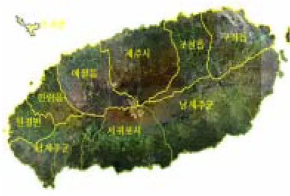
FIGURE 1 shows the study area in Jeju Island, Korea. In order to develop the entire detailed survey, the interpretation of high-resolution satellite images and classification
and GPS data survey were first performed in this study. Also, the various GIS layers such as topography map, forest type map, forest cadastral map and cave distribution map etc.
and the attribute data based on forest inventories were constructed. In addition, the training points of vegetation, soil and forest site index were recorded on topography map scaled in 1/5,000.
FIGURE 1. The study area in Jeju Island
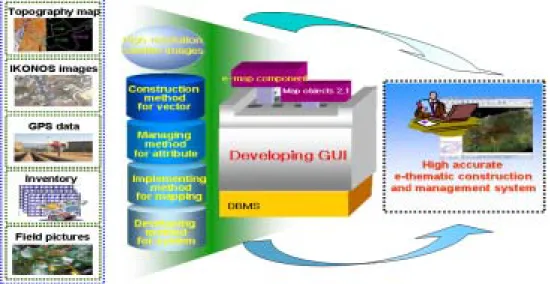
FIGURE 2 shows the system development concept diagram. The spatial data should be constructed in first stage especially considering the process of high-resolution satellite images and the system users' request. Then e-map component would be developed and integrated with the e-thematic constructing and management system for supporting forest administrative service especially constructing forest land use map, forest industry map, forest tour map and forest property map.
THE DEVELOPMENT OF e-THEMATIC CONSTRUCTION
AND MANAGEMENT SYSTEM
This system was developed based on Windows 2000 and implemented by using Visual
Basic 6.0 as development programming language, Map Objects 2.1 of ESRI as GIS component and Access 2000 as DBMS, respectively under intranet network environment.
Before developing the high accurate e-thematic construction and management system, we have focused on developing and embedding the e-map component and integrating other application. For this, there are four main technological criteria including the method for vector construction, method for mapping between attribute data and spatial data, implementing method for e-component and applying idea for this component.
1. The design of e-map component
When the certain component is designed there are several diagram to define system
action. Especially use case diagram indicates the system actor, the system function and its circumstance very well(D'Souza, 1999).
Therefor FIGURE 3 shows 7 user actions when the system user contact to e-map menu.
2. The development of e-map component
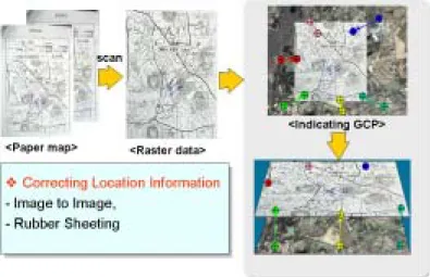
1) Function for correcting location information
This function is to correct the location information after paper map is scanned and then converted to raster data type as show in FIGURE 4. The raster map data would have the coordination by indicating GCP after performing geometric correction with satellite images, digital topography map or GPS location data, which is already reprocessed.
FIGURE 2. The system development concept diagram
FIGURE 3. User case diagram to define e-map component
FIGURE 4. Function for correcting location information
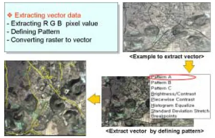
2) Function for generating vector data from raster data
This function is to generate vector data from raster data such as satellite image or image map having the coordination system. There are three kinds types of generating vector data as shown in FIGURE 5, 6 and 7.
The first method is to extract R, G, B pixel value on each pixel of raster data, define pattern or image processing methods, which
are existing, and then convert the result of extracting to vector as shown in FIGURE 5. The second method is to implement vectorzing interface by hardware devices such as scanner FIGURE 5. Function for generating vector data from raster data(1)
FIGURE 6. Function for generating vector data from raster data(2)
FIGURE 8. Function for modifying spatial data so that the various thematic maps could
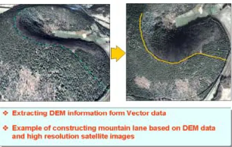
construct easily as shown in FIGURE 6. The third method is to extract DEM information(x, y, z) from referenced data so that the detailed vector information such as mountain lane could be constructed as shown in FIGURE 7.
3) Function for modifying spatial data This interface is to edit the spatial data type such as deleting vertex, splitting line and polygon, merging line and polygon, dividing node of line and changing annotation type and so on as shown in Fig 8.
FIGURE 7. Function for generating vector data from raster data(3)
FIGURE 9. Function for constructing attribute data
4) Function for constructing attribute data This interface to define the field type and generate table so that the database structure between the attribute data and spatial data could have consistence as show in FIGURE 9. Also, the change of spatial data such as split divides or merges could be reflecting on attribute data.
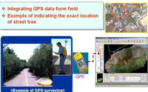
5) Function for integrating GPS surveying data
This interface is to add the GPS surveying data to the system and map to satellite images map or other thematic maps. FIGURE 10 shows the example to indicate the exact location information of street tree and map this to IKONS and thematic map.
FIGURE 10. Function for integrating GPS surveying data
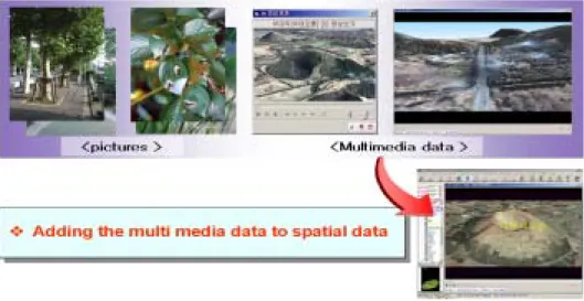
6) Function for linking with GIS multimedia data
This is interface to link various multimedia such as field pictures, moving images, web site and etc. to the system so that the current field status should be more understandable and the system could be easy accessible aw shown FIGURE 11.
7) Function for composing map layout This is interface to define the map composition layout such as scale, map name, area name, map index, map view, coordination, legend, symbol and index and print them. FIGURE 12 shows the interface for high-resolution forest map book in Jeju Island area, in detail.
2. The integration of e-Component with forest application system
This satellite images based high accurate e-thematic construction and management system for supporting forest administrative service was developed based on Windows 2000 and implemented by using Visual Basic 6.0 as development programming language, Map Objects 2.1 of ESRI as GIS component and Oracle 9i as DBMS, respectively under intranet network environment as shown in FIGURE 13.
Through this system, the forest officials could generate more detailed topography and desired thematic map. In addition, the data consistency in DBMS could be maintained by using SDE(Spatial Database Engine) for their job and share the standard forest database with others in real time.
FIGURE 11. Function for GIS multimedia data
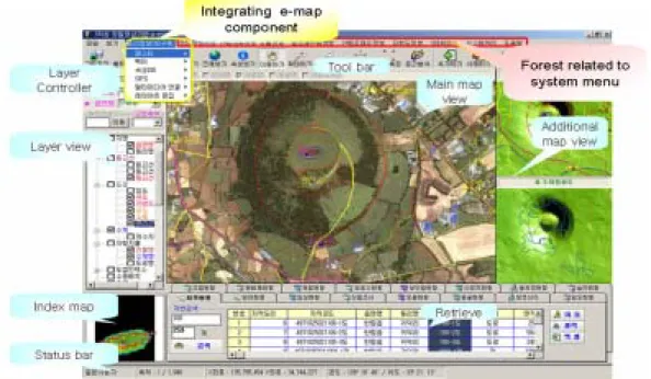
FIGURE 14 shows the main interface of the satellite image based high accurate e-thematic construction and management system, which has main menu, tool bar, area controller, layer controller, index view, main view, retrieval
view, status bar and especially e-map component. The main thematic map is IKONOS images based on DEM and 51 thematic maps are overlaid.
FIGURE 15 shows the example of additional
FIGURE 13. The system development diagram FIGURE 12. Function for defending map layout
application system interface to figure out the forest species by buffering the certain area
and the statue of current forest by retrieving database.
FIGURE 14. The system main interface
FIGURE 15. The additional application system interface for forest area management
Moreover, this system has the fundamental GIS interface such as measuring distance and area and zoom in/out/pan, the retrieval interface for spatial and attribute data, the GIS analysis such as buffering, the interface to modify spatial data and its attribute data, the interface to provide media data.
The result of constructing this system helps to manage spatial data scientifically and effectively and then support the certain standard method for domestic forest information management. In addition, through this system the foundation of domestic GIS technology would be increased dramatically having GIS component reusability and interoperability in related domains. Also, this is expected to be vital for sound decision making at local, regional, state, central and global level, for planning and implementation(Jo, etc. 2004).
REFERENCE
D'Souza, D. F., and A. C. Wills, Objects.
1999. Components, framework with UML:
The Catalysis Approach. Addison-Wesley Dong-Jun Kim, Gerard F. Schreuder and
Yeo-Chang Youn. 2003. Impacts of the
Engineering Applied to Networking &
Parallel/Distributed Computing. pp.483-493.
Myung-Hee Jo, Young-Jin Heo, Joon-Bum Kim and In-Ho Kim. 2003. Developing application system of forest information using digital photogrammetry and GIS.
Proceedings of the 24th Asian Conference on Remote Sensing. pp.799-801.
Myung-Hee Jo, Yun-Won Jo, Dong-Young Kim, Joon-Bum Kim and In-Ho Kim.
2004. Developing the 3D high-resolution forest mapping system using satellite images and GIS, Proceedings of International Symposium on Remote Sensing 2004 & 20th Anniversary of the Korean Society of Remote Sensing.
pp.322-325
Myung-Hee Jo. 2005. The Perspective and Fusion Method for High-Resolution Image with New GIS Technology in KOREA. Paper and Proceedings of the Geographic Information System Association. pp.27-32.
Myung-Hee Jo, Yun-Won Jo, Dong-Young Kim. 2005. Designing and Developing E-Map Component using UML.
Proceedings of International Symposium on Remote Sensing 2005. pp.466-469