Real-time monitoring of berthing/deberthing operations process for entering/leaving vessels using VTS system in Busan
northern harbor, Korea
Dae-Jae L
EE*
Division of Marine Production System Management, Pukyong National University, Busan 608-737, Korea
The process of berthing/deberthing operations for entering/leaving vessels in Busan northern harbor was analyzed and evaluated by using an integrated VTS(vessel traffic service) system installed in the ship training center of Pukyong National University, Busan, Korea. The integrated VTS system used in this study was consisted of ARPA radar, ECDIS(electronic chart display and information system), backup(recording) system, CCTV(closed-circuit television) camera system, gyro-compass, differential GPS receiver, anemometer, AIS(automatic identification system), VHF(very high frequency) communication system, etc. The network of these systems was designed to communicate with each other automatically and to exchange the critical information about the course, speed, position and intended routes of other traffic vessels in the navigational channel and Busan northern harbor. To evaluate quantitatively the overall dynamic situation such as maneuvering motions for target vessel and its tugboats while in transit to and from the berth structure inside a harbor, all traffic information in Busan northern harbor was automatically acquired, displayed, evaluated and recorded. The results obtained in this study suggest that the real-time tracking information of traffic vessels acquired by using an integrated VTS system can be used as a useful reference data in evaluating and analyzing exactly the dynamic situation such as the collision between ship and berth structure, in the process of berthing/deberthing operations for entering/leaving vessels in the confined waters and harbor.
Key words : Berthing/deberthing operations, VTS system, Busan northern harbor, Real-time tracking
*
Corresponding author: [email protected], Tel: 82-51-629-5889, Fax:82-51-629-5885VTS(vessel traffic service) . VTS
, AIS , , VHF
, CCTV
,
, ,
. ,
, ( )
,
, .
VTS
, , ,
, ,
, HarborGuard(L 3 communications,
2008) .
,
.
, , ,
.
, . ,
. ,
,
(Thoresen, 2002; Oda et al., 2004; Yang et al., 2004; Yoon et al., 2007; Kitade et al., 2009).
VTS
,
.
(35 06 .827N, 129 05 .295E) ,
( )
, .
VTS
ECDIS(JAN 901M, JRC FEA 2807,
Furuno), ARPA (JMA 9923, JRC; FAR
2827, Furuno), AIS(AI3000, Euronav), CCTV
(closed-circuit television), gyro compass(GRC 50,
Simrad), , DGPS (GP37, Furuno),
VDR(Model3000, Transas), VHF ,
Fig. 1 ,
backup (PM3D,
) .
ARPA
,
,
X band ARPA
, , ARPA
2 backup . backup
(radar target extractor(RTX)) 12 bit, 40 MHz
echo memory map ,
. ARPA
25 kW , Furuno ,
, 0.95 , 20 , 24rpm , JRC
0.8 , 20 , 26rpm .
AIS
, ,
AIS
ARPA
, .
AIS , , RS232C protocol
$AIVDM $AIVDO sentence ECDIS ENC chart
sentence .
sentence MMSI( ) ,
IMO , , , , ,
, ,
, GMT, , ,
, (ROT), status
, , , , ,
,
, , , ,
. CCTV
0.0007lux
(SDN 550, )
12mm 660mm
(H55ZME F, PENTAX) CCTV ,
CCTV ,
,
Fig. 1. Schematic configuration of a Vessel TrafficService(VTS) system for the real-time monitoring of berthing/deberthing operations process to entering/
leaving vessels in Busan northern harbor, Korea. The VTS system used in this study is a fully integrated coastal surveillance system consisting of ARPA radar system, PC-based ECDIS, DGPS receiver, CCTV camera system, Gyrocompass, and AIS system.
X-band RADAR
boardRTX
compassGyro DVR board
DVRPC
ECDIS DGPS
(25KW, 9FT)
AIS CCTV camera
. , CCTV
. ARPA
AIS
ECDIS ENC
. , backup
ARPA $RATTM sentence AIS
$AIVDM sentence ,
, CCTV
pan/tilt driver controller(KBD3000A,
Pelco) CCTV
, ,
.
backup ECDIS
ENC ARPA , AIS
ECDIS
DVR harddisk
. ,
ECDIS ARPA , AIS, CCTV
.
, , , ,
,
.
VTS ECDIS ENC
ARPA AIS
VHF
,
. ,
, ,
( )
. ,
,
Fig. 2. An example of real-time monitoring of the berthing/deberthing situation for entering/leaving vessels in Busan northern harbor, Korea. The tracked information of AIS targets including two tugboats is displayed on the ENC of a PC-based ECDIS with ARPA radar image and CCTV camera image. This ECDIS information is used to evaluate the change in the movement of all selected vessels.
, . VTS
,
( )
(MMSI 209109000) ARPA ,
AIS, CCTV
, Fig. 2 . Fig. 2
(MMSI440080000) (MMSI 440110920), ,
(MMSI 440103640)
AIS .
ARPA
AIS ECDIS
. Fig. 2 ARPA AIS
, , MMSI, , IMO , call sign, , , COG, SOG, HDG, CPA, TCPA ENC
, CCTV
ENC .
, Fig. 2 ARPA
, AIS CCTV
(UTC)
time tag harddisk ,
. AIS
,
, (
), ( )
. , Fig. 2
,
AIS , COG, SOG
. AIS
, ,
Fig. 2
AIS image
CCTV
.
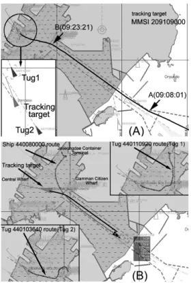
Fig. 3. (A) Real-time monitoring of berthing operation process for the entering vessel(MMSI209109000) being approached toward the pier to be berthed along the entering waterway. (B) Running routes of leaving vessel(MMSI440080000) and two tugboats(MMSI 440110920/440103640) in Busan northern harbor, Korea.
, VTS
ARPA radar, AIS, VHF ,
. ,
(false echo) ARPA radar
AIS VHF
. , Fig. 2 ,
. AIS
, Fig. 3 .
Fig. 3(A) Fig. 2 (MMSI
209109000) ,
, Fig. 3(B)
(MMSI 440110920)
(MMSI440080000) Fig. 3(A)
(MMSI 440103640, MMSI
440110920) AIS
.
Fig. 3 (A) (B)
3knots AIS
, 3knots
. , Fig. 3(A)
(HDT, COG) ROT
Fig. 4
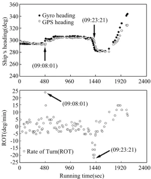
. 294 , 11.2knots
09:08:01
A ,
305
ROT 0 /min
+23.6 /min , ,
ROT 0 /min
. 11.6knots
360 340 320 300 280 260
2400 480 960 1440 1920 2400
Ships heading(deg)
25 20 15 10 5 0 -5 -10 -15 -20
-250 480 960 1440 1920 2400
ROT(deg/min)
Running time(sec)
Fig. 4. Relationship between ship s heading and ROT variations for the entering vessel being approached toward the pier to be berthed along the entering waterway of Busan northern harbor.
Gyro heading GPS heading
Rate of Turn(ROT) (09:08:01) (09:08:01)
(09:23:21) (09:23:21)
09:23:21 B , 283
ROT
0 /min 21.6 /min
. ,
ROT 0 (+)15
.
, 107
50,000
, (ROT )
, 30 /min
. Fig. 3(A) (MMSI 209109000)
ROT
$TIROT sentence ROT( /min) . Fig. 3 (A) (B)
, ,
, Fig. 5 .
Fig. 5 1(MMSI440103640)
09 24 25 35
06 .434N, 129 03 .681E
docking , 2(MMSI
440110920)
09 25 04 35 06 .454N, 129 03 .570E
docking . , 1
2
Fig. 5. Tracked results of maneuvering motions for a target ship(MMSI 209109000) approaching to the central wharf in order to get alongside to her berth in Busan northern harbour. The maneuvering motions for a tugboat(MMSI 440110920) approaching toward the entering vessel from Jaseongdae container terminal and a tugboat(MMSI 440103640) approaching toward the entering vessel from Gamman citizen wharf were simultaneously tracked, respectively.
14500 13100 11700 10300 8900
75005000 7100 9200 11300 13400 15500
0 480 960 1440 1920 2400 0 480 960 1440 1920 2400
0 480 960 1440 1920 2400
15 12 9 6 3 0
12
9
6
3
0
12
9
6
3
0
Diff. of latitude(m) Speed(knot) Speed(knot)
Diff. of longitude(m)
(A) (C)
(B) (D)
Tug 1(440103640) STBY tracking vessel s route Tug 1 route(440103640) Tug 2 route(440110920)
tug STBY Jaseongdae Container Terminal (09:25:04)
(09:24:25) Central Wharf
Tug 2(440110920) STBY Jaseongdae Container Terminal(Tug 2)
Gamman citizen wharf(Tug 1)
Gamman citizen wharf
tug STBY Tug 1 speed(440103640)
Tug 2 speed(440110920)
ship s speed
Running time(sec) Running time(sec)
Running time(sec)
Speed(knot)
docking
7.7knots, 7.2knots ,
1 2 docking
9.0 knots 8.4 knots . AIS
, .
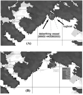
, Fig. 2 Fig. 3(B)
(MMSI 440080000) ARPA
radar AIS
(MMSI440110920)
, ,
ARPA AIS
Fig. 6 . Fig. 6 ARPA
, AIS
. , AIS
, AIS COG,
SOG GPS ( )
gyro compass
(HDT) ,
. , Fig. 6 ARPA AIS
,
. , AIS
ARPA
Fig. 7 . Fig. 7
a ,
Fig. 6. AIS data and ARPA radar images for the deberthing vessel(MMSI 440080000) and its tugboat(MMSI 440110920) towing the vessel that is berthed port side alongside to the NW face of the Jaseongdae container terminal out of the pier.
(A)
(B) Fig. 7. Changes in the maneuvering motion tracks for the deberthing vessel being towed by one tugboat from the berth and its tugboat during the deberthing operation process. The deberthing vessel being assisted out of the pier by one tugboat from central wharf and its tugboat are shown with ship mark(or white circle) and black circle, respectively.
13750 13690 13630 13570 13510 13450
Diff. of longitude(m) tug s position(440110920) deberthing vessel(440080000) gyro heading
reference point (35 N, 129 E)
a a b
b
6950 7000 7050 7100 7150 7200 7250
Diff. of latitude(m)
, b
. AIS
,
, ,
ARPA AIS
.
Fig. 7 ROT
ROT
, gyro compass HDT
ROT
. , ROT ,
AIS HDT message ROT
, , ROT 10 /min
720 /min , ROT 10 /min 720 /min ,
0 /min
. ,
, (Nauticast,
2004). , Fig. 7
, ( ) COG
SOG GPS
, AIS
COG gyro compass (HDT)
. ,
Fig. 8 . Fig. 8
0.5 3.0knots , , COG HDT
. ,
3knots
COG HDT
. , Fig. 7
, ( ) ,
.
VTS , ECDIS ENC
ARPA , AIS
. , VHF
,
.
, ARPA Fig. 2
, , shadow zone
masking
radar .
AIS ,
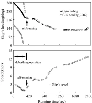
Fig. 8. Variations in ship s heading and speed of the deberthing vessel being towed by one tugboat from the berth during the deberthing operation process.
360 288 216 144 72 0 15 12 9 6 3 0
Ships heading(deg)
Running time(sec) Gyro heding GPS heading(COG)
Ship s speed self-running
self-running deberthing operation
0 420 840 1260 1680 2100
Speed(knot)
AIS target swapping .
ARPA , AIS CCTV
( )
, crane
,
, AIS, CCTV ARPA
Fig. 9 Fig 10 . Fig. 9 AIS CCTV
,
, Fig. 10 AIS,
CCTV ARPA
.
, Fig. 9 (MMSI 525019103)
AIS gyro compass (HDT)
,
. , COG 1(MMSI 440112730) 2(MMSI440113180) COG
40
COG 40
pushing ,
CCTV camera . , AIS CCTV ,
. , DGPS COG
(tugboat)
. ,
2004
Fig. 9. AIS display and CCTV image for berthing vessel(MMSI 525019103) and two tugboats pushing the port bow and stern of berthing vessel towards the Sinseondae container terminal wharf to be berthed on the eastern face.
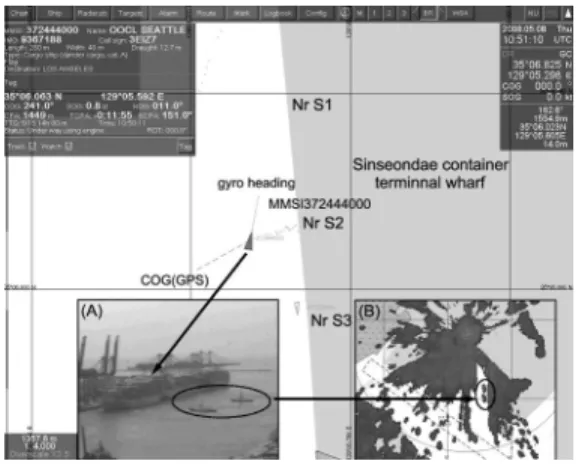
Fig. 10. ARPA radar and CCTV images for the deberthing vessel being assisted out of the pier by two tugboats from Sinseondae container terminal wharf and its tugboats towing the deberthing vessel that was berthed starboard side alongside to the eastern face of the pier.
( 108 5 ) 50 ,
(AIS) .
, Fig. 10 (MMSI 372444000)
AIS VDL message AIS , AIS
.
, ,
50 AIS
.
, Fig. 10 AIS VDL message ARPA radar CCTV camera
. Fig. 10 Nr S2 , gyro heading(HDT) 11 , GPS heading(COG) 241
230 ,
GPS
COG . , GPS COG
GPS ,
gyro compass ,
HDT COG
. ,
, GPS
COG ,
.
.
,
PSC(port state control)
VTS .
PSC
, VTS
. 1993
/ , , / , /
, , , , , ,
, , 13
. ,
, VTS
, VTS
,
. ,
, ,
.
. ,
VTS maritime
surveillance system
.
, (VTS)
, . ,
ARPA AIS
, CCTV
,
,
. ,
VTS , VTS
.
VTS
.
Kitade, T. and Y. Isamu, 2009. Harbor surveillance radar/camera system. private communication, 1 6.
L 3 Communications(Klein Associates, Inc.), 2008.
Integrated waterside surveillance and security system(IWSSS, HarborGuard), Performance tests results . 1 8.
Nauticast, 2004. AIS(X Pack DS) installation manual(version 1.0). 24 25.
Oda, H., S. Horie, N. Hamamoto, M. Uchida and T.
Nagai, 2004. New berthing support system with starfire DGPS. The 2004 International symposium on GNSS/GPS, 1 14.
Thoresen, C.A., 2002. Port designer s handbook, Recommendations and guidelines . Thomas Telford, 95 110.
Yang, S.Y., K.H. Sohn, H.Y. Lee, M.K. Ha, H.S. Kim, J.H. Lee and N.K. Im, 2004. A study on development of ship manoeuvring simulator for berthing/deberthing. Proceedings of the Annual Autumn Meeting, SNAK, 57 62.
Yoon, J.D., H.Y. Jong and C.K. Lee, 2007. A study on the method of conducting a large container vessel safely to the newly built container pier to get alongside in Busan Harbour. Journal of the Korean Society of Marine Environment & Safety, 13(2), 147 153.