Relationship between street-connectivity and multi-family residential parcel values
Comparison of two urban development projects in Korea
가로 연결도와 공동주택 지가 사이의 연관성 고찰분당과 평촌 신도시 사례 비교를 중심으로
1
안용진*Ahn, Yong-Jin
Abstract
This research aims to examine the effects of urban environmental factors on land values, comparing with two development projects (Bun-dang and Pyung-chon) in Korea. The primary interest of this research is to assess the performance of urban design characteristic which emphasizes the compact development and land use mix to improve residents’ accessibility to urban facilities.
The analysis is conducted by measuring the relationships between the values of multi-family residential parcels and the access to transit and other uses (park, office, retail, and education uses) as well as their comparative location in the city. The proximities to five uses and subway stations are estimated using GIS program. Parcel level GIS data and land value data assessed in 1996 and 2003 are used to measure such relationship. The findings indicate that multi-family residential parcel values are significantly correlated to the proximity to education and park uses. The characteristics of street network are significantly related to the chronological change of multi-family residential parcel values as well. The direction of the relationships, however, varies by the condition of urban environmental factors.
색인어 : 가로 연결도, 공동주택 필지, 지가, GIS 분석, 공간구문 분석
Keywords : Street-connectivity, Multi-family residential parcel, Land value, GIS method, Space syntax
* Assistant Professor, Department of Urban and Regional Planning, Daegu University, Korea(대구대학교 도시지 역계획학과 조교수)
1. Introduction
1) Background & Goals
Korea has constructed parcels of new-towns which have various development goals according to not only socio-economy situation at the national level but also government spatial policy since 1960. For example, in 1960s, new-towns for industrialization and economic development, such as Ul-san, Po-hang, Ku-mi, and Chang-won, were developed, and as another type of new-town, Dae-deok, specialized complex for high-technology research and Gwa-cheon for decentralization of government complex followed the pattern of development driven by government (Lee et al, 2004). In 1980’s, housing oriented new-towns, such as five satellite cities around Seoul metropolitan area and Sang-kye and Mock-dong within the city-boundary of Seoul, were constructed. Since then, the development plans for the second period new-town (e.g., Bun-dang, Pyung-chon, Il-san, and San-bon) have been continuously suggested and realized.
Unlike redevelopment in the extant built area, new-town development has opportunity to realize urban form and urban space that urban planner and designer consider to be ideal by filling the vacant parcel without any obstacle (Ohn, 1996), and has also advantage to complete the plan for settlement physical environment in a relatively short time. In this vein, new-town development might become a good sample to know how newly created urban space reacts to complex physical environmental system. However, although several new-town development projects have been introduced to date, we are still unaware of any knowledge based on the scientific verification from empirical study and the feed-back process after completion. All in all, the issue of quality is more focused than that of quantity in housing supply policy, and the quality of life is considered a primary factor in built environment. Therefore, it is time to assess the performance of current urban design trend which emphasizes the compact development and land use mix by conducting the empirical study on spatial characteristics including residents’ accessibility to urban facilities. This assignment will provide the basic information and direction for well-planned human settlements.
2) Overview of research frame
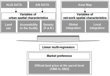
Among five new-towns within Seoul metropolitan region, this research dealt with two
Figure 1. Overview of research flow
cases, Bun-dang and Pyung-chon, which are located closely each other in terms of geography. Categorized into the second period new-town, they were built to primarily solve the problem of housing shortage in the end of 1980’s with Il-san and San-bon.
However, unlike earlier planned new-towns, both case areas this study revisited provided lots of intra structure including a huge park area and various convenient facilities for a comfortable neighborhood (K.L.C., 1997a; K.L.C., 1997b). Especially, they proposed the concept of land use planning for high-density, mixed-use, and housing in the vicinity of job, and improved the accessibility to retail facilities by suggesting walking-friendly design approach in neighborhood planning.
The analysis on the spatial characteristics was conducted using GIS data and AIS (Architecture Information System) data at the parcel level, focused mainly on attributes such as land use, accessibility (i.e., distance to the parcel for specific facility), and development density (FAR). Also, as another quantities analytic methodology, space syntax by axial map in ArcView 3.3 is used to investigate net-work spatial characteristics.
Main concern of this study is the relationship between land value and two quantitative
variables measured by spatial characteristic analysis mentioned above. To illuminate this
relationship, linear multi-regression model is applied.
2. Literature review
1) Analysis and evaluation of spatial structure in new-town
There have been lots of discussions related to the analysis and evaluation of urban spatial structure in new-town area to date. Large volume can be categorized into four according to the research subject: land use pattern (Choi & Park, 1999; Lee & Hwang, 2006), post-occupancy satisfaction and residents preference (Han & Kim, 1999; Lee, 2001; Shin, 1999), spatial allocation and layout (Kim, 2004; Kim, 2006), land values and housing price (Kim & Park, 2003; Lee & Lee, 1999). First of all, focusing on a large portion of commercial parcel which has remained unsold, Choi & Park (1999) showed statistically that the probability and speed of the sale of individual parcels are inversely related to aggregate ratio of commercial to residential floor areas. Based on this finding, they verified that over-supply of commercial floor area is the main reason for low salability.
Focusing on the public facilities provided at three new-towns in Seoul metropolitan region, Han & Kim (1999) analyzed post-occupancy satisfaction and residents’ preference with the assumption that their post-occupancy satisfaction represents the residents’
characteristics. More concretely, this study suggested the adaptable index for evaluation and explored how much each facility effects on the satisfaction. However, it did not reveal any implication in terms of urban planning and design. For example, the relationship between differences of the statistical results of three case areas and urban spatial characteristics in reality is still unknown. With regard to spatial allocation and layout, Kim (2004) championed that the form of neighborhood is mainly determined by the surrounding street, comparing the layout types from the aspects of spatial composition factors such as transportation characteristic and housing type. All in all, he pointed out the problem that there is no space playing the role of neighborhood center as activity core. However, it is difficult to deduct the implication acceptable and referable, from this study, in designing neighborhood of new-town due to using a small number of types.
Kim & Park (2003) examined the geographic difference of the change of local
housing prices including housing within new-town area through the cluster analysis and
multi-regression with the character variables of each district. This study found that there
is the correlation between rental fee and housing price, and concluded that housing is
more likely to be affected by variables on demand side than those of supply side.
However, it lacked the time-series dataset available and did not consider the variables related to spatial characteristics.
2) Analysis on urban space by space syntax
Space syntax is quantitative model for analysis on spatial characteristics of individual space or specific public area by investigating the net-work characteristics of spatial structure mainly formed by open-space like an aisle and the street. Key elements in quantitative measure are integration, degree of axis line, and connectivity which also give visual information about the intensity of accessibility.
It has been applied to lots of researches, from macro- to micro scale, to explain the change pattern of urban spatial structure by the artificial development (e.g., new-town development- and redevelopment project) with time-series data; the situation of spatial structure through the cross-section approach (Kim & Kwan, 2002); the pattern of land use and pedestrian characteristics in specific district (Shin & Kim, 2006), and to suggest the rational design process that can be utilized in the street lighting design considering the characteristics of the space in condominium site at the micro level (Choi et al, 2005).
Moreover, the subject area of research using space syntax has been continuously expended to forecasting a ripple effect of development plan on project area after completion of a construction work, not merely analyzing the current status (Yu et al, 2006), and joining GIS analysis tool and spatial statistic analysis (Ha, 2005). For example, focusing on Pyung-chon (An-yang), Kim & Kwan (2005) scrutinized the differentiation of urban space occurred by new-town development project with time-series data and regression. As major finding, the heterogeneity of newly built area was pointed out as serious problem in the city design which ascribes to the lack of consideration on spatial isolation. Finally, this study suggested the buffer zone as planning methodology for reducing isolation between old and new urban core. However, there is limitation in that they weighed on a sole case without touching other cases with similar physical condition.
Also, Shin & Kim (2006) conducted the regression analysis on the characteristics of
pedestrian net-work and pedestrian volume to demonstrate the effect of spatial net-work
on pedestrian environment, and to pronounce the characteristic of walking-behavior by
land use. It is notable to provide the correlation between the characteristics of pedestrian
net-work and pedestrian volume considering the land use pattern (residential and
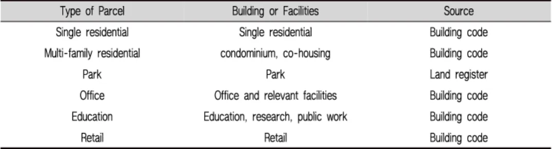
Type of Parcel Building or Facilities Source
Single residential Single residential Building code
Multi-family residential condominium, co-housing Building code
Park Park Land register
Office Office and relevant facilities Building code
Education Education, research, public work Building code
Retail Retail Building code
Table 1. Major building or facilities according to type of parcel for a specific land use at the parcel level
commercial area), however, newly defined concepts including the characteristics of pedestrian net-work are slightly unclear, by which a logical leap might be occurred in putting out the implication from the result.
Lastly, Yu et al (2006) examined two Balance Development Projects in Seoul: Mi-a community project and Gil-um new-town project, to anticipate the effect of development project driven by city government on urban spatial structure of Seoul, to evaluate the change of centrality into multi-core city, and to suggest the alternative of the overall Balance Development Projects from the perspective of urban planning. However, it lacked the integrated consideration on variables affecting on the change of spatial structure except for net-work attribution.
3. Analytic methods
1) Analysis on urban spatial characteristics
One of major concerns of this study is to verify the relationship between land value
of multi-family residential parcels and variables related to urban spatial characteristics
such as land use and accessibility to other facilities focusing on two case study areas,
Bun-dang and Pyung-chon new-town. To do this, first of all, parcels for a specific use
where the development process has been finished were categorized into total 6 types
based on the information of building code and land register: single-(detached) family
residential, multi-family residential, park, office, retail, and education, as shown in Table
1. The data for analysis such attributes of physical environment as land value, land use
type, development density, and so on, were obtained from GIS and AIS (Architecture
Information System) dataset. Next, variables of urban spatial characteristics from two
dataset were used for measure of the percentage of area by land use as well as accessibility (i.e., distance between multi-family residential parcel and facilities for 5 major uses including subway station) at the level of parcel through the tools of ArcView and ArcGIS.
2) Land use characteristics
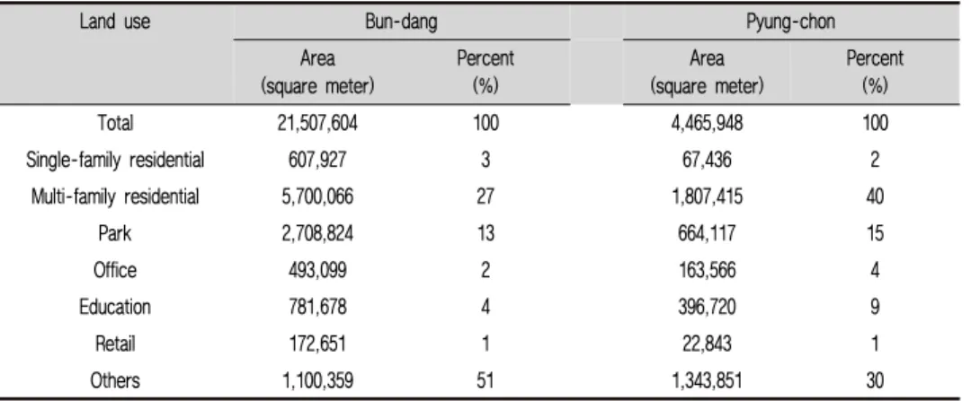
Based on the 6 types of parcel mentioned above, the summary of land-use distribution in two case areas is as follows (Table 2). Among 6 types of parcel, multi-family residential parcel showed the highest radio of area in both case study areas; especially, multi-family residential parcel in Pyung-chon holds 40% of total area. There was no difference between the radios of park area within two areas, showing 13% (Bun-dang) and 15% (Pyung-chon), respectively, but in the case of converting into the area per 1 square meter of multi-family residential parcel, the radio of park area (0.47) in Bun-dang was approximately 30% higher than that (0.37) in Pyung-chon.
Land use Bun-dang Pyung-chon
Area
(square meter) Percent
(%) Area
(square meter) Percent (%)
Total 21,507,604 100 4,465,948 100
Single-family residential 607,927 3 67,436 2
Multi-family residential 5,700,066 27 1,807,415 40
Park 2,708,824 13 664,117 15
Office 493,099 2 163,566 4
Education 781,678 4 396,720 9
Retail 172,651 1 22,843 1
Others 1,100,359 51 1,343,851 30
Table 2. Summary of land-use distribution each type of parcel
For more reasonable comparison, converting into the area per 1 square meter of
multi-family residential parcel, the radio of education area (0.22) in Pyung-chon was
slightly higher than that (0.14) in Bun-dang. Others (office and retail parcel) are 4% or
less in both areas.
3) Accessibility to parcels for specific facilities
This study investigated the accessibility to parcels for specific facilities such as subway station, park, office, education, and retail from multi-family residential parcels except for single-family residential. This is because multi-residence is a dominant housing type in residential area. More specifically, the accessibility is measured by the direct distance from the central point of multi-family residential parcels to other facilities mentioned above using GIS program.
As shown in table 3, the accessibility to four facilities (e.g., subway station, park, office, and education) in Pyung-chon is better than that in Bun-dang except for the accessibility to retail. Especially, in case of park, the average of distance between multi-family residential parcel and park area in Pyung-chon is shorter than that of Bun-dang around 40% even though Bun-dang has a huger park area than Pyung-chon in absolute amount. From this finding, it is possible to say that the geographic imbalance of park facility in Bun-dang is much more serious than Pyung-chon. Also, considering that the average of the distance to subway station from each multi-family residential parcel is 1km or more (Bun-dang) and 865m (Pyung-chon) respectively, it is difficult for residents to walk to subway station without any transportation in both case areas.
However, in total, the accessibility by walking showed the satisfactory condition from the finding that the average distances to other facilities are around less than 400m except for the average distance of retail (743m).
Land use Bun-dang (m) Pyung-chon (m)
Average Min Max Average Min Max
Subway station 1,035 14 2,749 865 143 2,236
Park 135 10 947 78 10 264
Office 350 10 1,042 305 10 886
Education 174 10 1,118 122 10 416
Retail 471 10 1,744 743 22 2,125
Table 3. Distance between multi-family residential area and other land uses (facilities)
4) Net-work connectivity by space syntax
Net-work spatial characteristic with regard to street connectivity was measured by
space syntax model which is broadly used as quantitative measurement not only for
estimation of travel volume but also for evaluation of the accessibility between two
specific spots in various fields like architecture, urban design, and urban transportation.
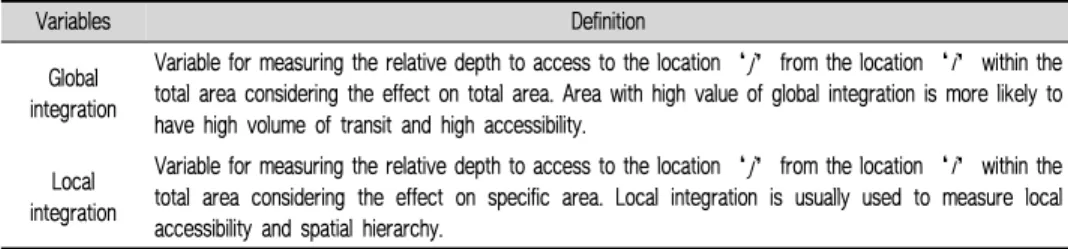
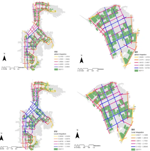
In this paper, among the variables showing the status of net-work system, two measurements, global integration and local integration, were identified on the main street level using Axwonman 3.0, extension of ArchView for space syntax analysis. The results of analysis on net-work spatial characteristics are as follows (refer to Figure 2).
More specifically, in Pyung-chon, blue marked streets with high value of global integration are well connected across total area making the grid pattern, whereas in Bun-dang parcels of blue marked streets are located on the south side showing irregular grid pattern without well-connected throughout the area. Also, regarding local integration, in Bun-dang, the area with high local integration is concentrated on the center showing the lower local integration with the distance from the center, whereas in Pyung-chon local integration has closely similar pattern to global integration. In this vein, it is possible to say that Pyung-chon has relatively higher intelligibility
1than Bun-dang, from the perspective on space syntax methodology.
4. Results: the association between urban spatial characteristics and land value
The analysis on relationship between land value and variables of accessibility to other facilities from multi-family residential parcels and variables of net work spatial characteristics by space syntax was conducted (refer to Table 4). Data of land value used in analysis are based on the official land price of multi-family residential parcel from 1996 to 2003, and the total number of observation is 380 (Bun-dang: 307 parcels, Pyung-chon: 73 parcels).
As a result of analysis on relationship between land value and two variables related to spatial characteristic of case study areas, land value of multi-family residential parcels in Bun-dang was statistically significant with the variable of accessibility to five facilities: subway station, park, office, education, and retail (refer to Table 6). More
1 Intelligibility is often used in space syntax as index for measuring the quality of spatial characteristics across the total area. For example, the place with high degree of intelligibility is easy to be recognized from any point within total area, and has the systematic pattern in space use (Shin and Kim, 2006).
specifically, in Bun-dang, land value of multi-family residential parcels had negative relation with the accessibility to park and positive relation with other 4 types of parcel as well as net-work variables.
Variables Definition
Global integration
Variable for measuring the relative depth to access to the location ‘j’ from the location ‘i’ within the total area considering the effect on total area. Area with high value of global integration is more likely to have high volume of transit and high accessibility.
Local integration
Variable for measuring the relative depth to access to the location ‘j’ from the location ‘i’ within the total area considering the effect on specific area. Local integration is usually used to measure local accessibility and spatial hierarchy.
Table 4. Variables used in space syntax analysis
Variables Definition
Accessibility to subway station Distance to subway station near observation Accessibility to park Distance to park parcel near observation Accessibility to office Distance to office parcel near observation Accessibility to education Distance to education parcel near observation
Accessibility to retail Distance to retail parcel near observation Global integration Degree of total integration on the vicinity road Local integration Degree of local integration on the vicinity road Table 5. Variables used in spatial characteristic analysis at the parcel level
Also, in Pyung-chon, land value of multi-family residential parcels wss solely significant with the variables of accessibility to education showing the positive relation in 1996, whereas all variables were statistically significant in 2003. Especially, the accessibility to subway station, park, office, and retail had negative association with land value of multi-family residential parcels except for the accessibility to education.
Moreover, it is notable that two net-work variables of Pyung-chon have much higher
positive coefficient than those of Bun-dang in 2003. Therefore, it was verified that there
is the correlation between land value of multi-family residential parcels and some of
variables related to urban spatial structure.
Figure 2. Result of net-work characteristics analysis in Bun-dang (Left) and Pyung-chon (Right) (Upper: Global integration; Lower: Local integration)
New-town Year Accessibility variables Net-work variables
Subway Park Office Education Retail Global Local
Bun-dang 1996 -.332** .097 -.412** -.176** -.238** .267** .285**
2003 -.337** .157** -.392** -.211** -.215** .254** .309**
Pyung-chon 1996 .140 .095 .002 .272* .132 -.054 -.056
2003 -.467** -.089* -.257* .424** -.553** .563** .545**
Table 6. Correlation between land price and spatial characteristic variables
* Statistically significant level at the 95%
** Statistically significant level at the 99%
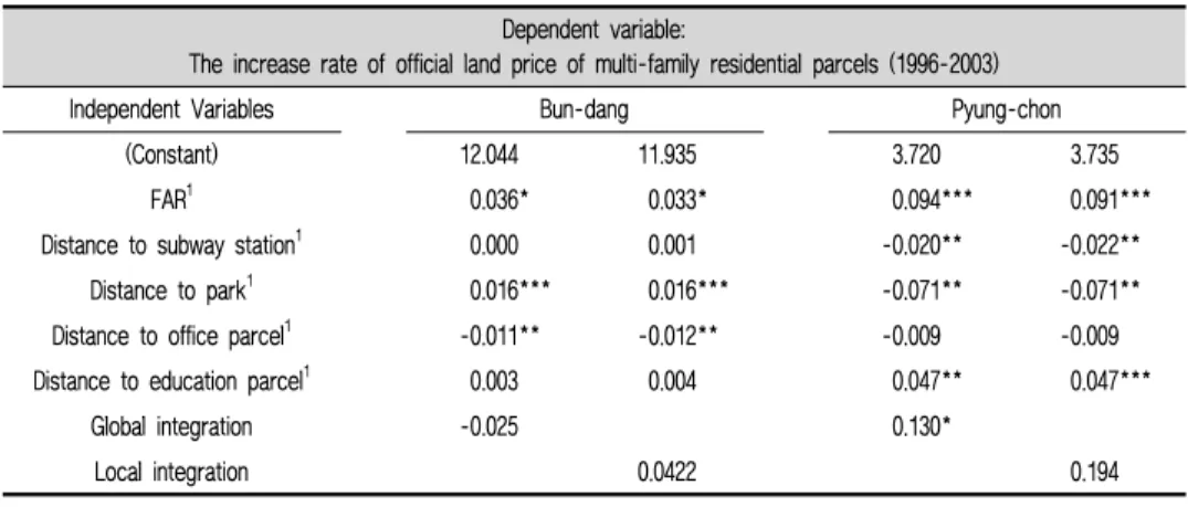
From these findings, it is possible to infer that the high accessibility to major convenient facilities for residence, suggested in development process as design goals, influenced partially on the land value. As mentioned above, this study used the time-series dataset from 1996 to 2003 regarding the percent change of official land value of multi-family residence at the parcel level to enunciate the association between the long term variation of land value of multi-family residential parcels and variables of spatial characteristics, not land value in specific point of time. In the linear multi regression model, the percent change of official land value log transformed was adapted to dependent variables controlling the variable of FAR at the parcel level, and two net work variables (i.e., global and local integration) by space syntax were analyzed separately to solve the problem of multi-collinearity. Also, for the same reason, the variables of distance to retail parcels were excluded in regression model.
Dependent variable:
The increase rate of official land price of multi-family residential parcels (1996-2003)
Independent Variables Bun-dang Pyung-chon
(Constant) 12.044 11.935 3.720 3.735
FAR
1
0.036 * 0.033 * 0.094 *** 0.091***Distance to subway station
1
0.000 0.001 -0.020 ** -0.022**Distance to park
1
0.016 *** 0.016 *** -0.071 ** -0.071**Distance to office parcel
1
-0.011** -0.012 ** -0.009 -0.009Distance to education parcel
1
0.003 0.004 0.047 ** 0.047***Global integration -0.025 0.130 *
Local integration 0.0422 0.194
Table 7. Result of analysis using the time-series official land price data at the parcel level
1 log transformation
* Statistically significant level at the 90%
** Statistically significant level at the 95%
*** Statistically significant level at the 99%
As a result, the percent change
2of official land value in Bun-dang has increased sharply during the period as the distance to office parcels is short, and inversely, the accessibility to park showed the negative association with the percent change of land value. However, some variables such as the distance to subway station and education
2 (Land price officially reported in 2003 - Land price officially reported in 1996) / (Land price officially reported in 1996) * 100
parcels, and the net-work characteristics were not statistically significant. Next, in Pyung-chon, the higher accessibility to subway station and park parcels is, the more the percent change of land value increased, whereas the percent change of land value increased as the accessibility to education parcels is low. Lastly, global integrations in both case study areas were positive association with the increasing rate of land value, and it is confirmed that land value of multi-family residential parcels nearby the street located on the center much more increased than those on the outer.
Based on these findings, the difference of intelligibility between two case study areas better explains the change of urban spatial characteristics and physical urban context.
For example, in Pyung-chon with high intelligibility across the total area, the long-term value of land with high global integration much more increased than that of land with low global integration. However, the similar pattern between global integration and land price observed in Pyung-chon was not presented in the case of Bun-dang with low intelligibility.
5. Conclusion
This study examined urban spatial characteristic of two new-town projects in Korea, Bun-dang and Pyung-chon, where urban settings have been completely equipped since their development plans introduced firstly in 1980’s, focusing on the accessibility to 5 facilities for specific land uses, and the net-work characteristics. Both new-town projects have urban-design principals to improve the quality of built environment in neighborhoods by providing parcels of open-space and convenient facilities nearby residential area as well as introducing new-urbanism strategies such as high-density, mixed use, and pedestrian oriented site plan. Therefore, it is time to evaluate the effect of these strategies on the housing price in market.
To pronounce the preference in land market on the variables of urban spatial
characteristics measured before, this study conducted the correlation analysis on relevant
variables and the linear multi regression model using the parcel level GIS and AIS data
from 1996 to 2003. As a result, overall, the accessibility to retail and office facilities
by walking was good, but subway station and some of retails was not easy to access
by walking. Especially, the accessibility to park in Bun-dang was lower than that in
Pyung-chon, even though Bun-dang has much more park area per 1 square meter of multi-family residential parcel than Pyung-chon. This is mostly because lots of park areas were concentrated on the outer far from the allocated residential area in Bun-dang.
Next, from the result of analysis by space syntax, there is clear distinction between two areas in terms of street system. More specifically, Bun-dang places streets with high value of global integration on the specific area of the south side showing irregular grid pattern without well-connected throughout the area, but Pyung-chon has a grid pattern woven by streets with high value of global integration thereby being well connected across total area.
The difference of urban spatial characteristic affected partially on the different change pattern of land value. More detailed, from the result of correlation analysis on official land value and spatial characteristics in 2003, unlike Pyung-chon, land value of multi-family residential parcels in Bun-dang was high as the accessibility to park is low.
Also, there was positive correlation between the accessibility to education and land value in Bun-dang, but was negative relationship in Pyung-chon. All in all, the result of multiple regression models using time-series data for 7 years also revealed the similar pattern of the correlation among the variables.
The implications from these findings are as follows. First of all, the difference between the accessibility to facilities, finally, would influence on land value by making the commodity of land different. In other words, the direction of urban design for improving the accessibility to convenient facility from housing would be a good strategy affecting on the market preference of specific location. Second, as shown in the result of correlation analysis, the direction and magnitude of correlation between land value and accessibility to specific facility varies by their locality (i.e., condition of urban form factors). This means that the accessibility to facility is not solely working as the factor to improve the geographic preference represented to the land price. Therefore, the more detailed and extensive approach to design elements related to the overall condition of physical built environment, in tandem with the improvement of accessibility.
Lastly, the result of analysis on land value and net-work characteristics measured by
space syntax revealed that the difference of intelligibility (i.e., degree of the correlation
between global integration and local integration) of street, finally, can affect on the
preference for a specific place. From this conclusion, hereafter, the analysis using space
syntax might contribute to the plan for new town development project by applying for
estimating the hierarchy and geographic advantage of specific location in distribution
and allocation of land use zone.
Bun-dang and Pyung-chon projects have urban-design principals to improve the quality of built environment in neighborhoods by providing parcels of open-space and convenient facilities nearby residential area. The message taken away from this empirical study is that the difference between the accessibility to facilities would influence on land value by making the commodity of land different. The direction of urban design for improving the accessibility to convenient facility from housing would be a good strategy affecting on the market preference of specific location.
The accessibility to facility is not solely working as the factor to improve the geographic preference represented to the land price. Therefore, the more detailed and extensive approach to design elements related to the overall condition of physical built environment, in tandem with the improvement of accessibility.
Reference
1. Kim, Kab Sung & Park, Ju Young(2003) “The Spatial Pattern of Housing Prices; Seoul and New-towns”. Journal of Korea Regional Science Association, 19(1): 47-61.
2. Kim, Jin Kyun & Kwan, Young Sang(2002) “A Study on the Structural Differentiation of Urban Space Occurring in Newtown Housing Planning - Focused on ‘Anyang’ and
‘Pyungchoi Newtown’”. Journal of Architectural Institute of Korea (Planning and Design) 20(4): 69-76.
3. Kim, Young Soo(2004) “A Study on Spatial Configuration of Neighborhood through Five New Cities in the Capital Area”. Journal of Korea Regional society development Association, 29(2): 123-137.
4. Kim, Ju Young(2006) “Valuing Locational externalities of Apartment prices -In case of Bundang”. Journal of Korea Real Estate Analysis Association, 12(1): 27-38.
5. Shin, Jeong Cheol(1999) The analysis on comprehensive evaluation on New-town development in Seoul metropolitan area. Korea Land Corporation.
정책적 시사점
6. Shin, Hang Woo & Kim, Young-Ook(2006) Relationship between Pedestrian Network and Pedestrian Volume according to Pattern of Land. Urban Design Institute of Korea Regular Seminar at Chung-buk University: 128-138.
7. Lee, Chun-Ho(2001) “Analysis of Residential Satisfaction and Personal Characteristics of New-town in Seoul Metropolitan Area”. Journal of Korean Planning Association, 36(6): 191-204.
8. Lee, Hyun Ung & Lee, Man Hyung(1999) “Housing Price Determinants of New-towns within Seoul Metropolitan Areas”. Journal of Institute of Construction Technology, 18(1):
103-126.
9. Lee, Hyung Dong & Hwang, Chul Sue(2006) “The Spatio-temporal Change of the Land Use Pattern According to the Substantial Residential Site Development”. Geography Research, 40(1): 155-167.
10. Yu, Gyeong-Hwan, Lee, Myeong-Hun & Kim, Young-Ook(2006) “A Study on the Impact of the Balance Development Project on Urban Spatial Configuration - In case of the Mi-a Balance Development Project in Seoul”. Journal of Korean Planning Association, 41(6): 51-63.
11. Choi, Mack Joong & Park, Young Kyu(1999) “Thesis : Ex Post Evaluation of Commercial Space Allocation in New-town: The Case of Bundang”. Journal of Korean Planning Association, 34(3).
12. Choi, An-Seop, Chang, Soo-Jung, Oh, Eun-Suk & Kim, Young-Ook(2005) “A Study on Street Lighting Design of Apartment Using Space Syntax”. Journal of Architectural Institute of Korea(Planning and Design), 20(4): 189-196.
13. Ha, Chang-Hyun(2005) A Study on Spatial structure analysis in a conurbation region using spatial autocorrelation technique. Dissertation in Kyung-sang University.
14. Han, Sang-Hyun & Kim, Kwang-Sik(1999) “An Analysis of Post-Occupancy Satisfaction with Public Facilities at New-towns in the Capital Region”. Journal of Korean Planning Association, 34(6): 41-59.
15. Kim, Young-Do & Kim, Ho-Chul(2007) “A Policy Direction for the Readjustment of Officially Announced Standard Land Price”. Journal of Korea Urban Management Association, 19(3): 3-22.
16. Korea Land Corporation(1997a) Development history of Bundang New-town.
17. Korea Land Corporation(1997b) Development history of Pyungchon New-town.
18. Lee, Sang-Moon, Lee, Kyu-In & Koo, Ja-Hoon(2004) Direction and challenge for
sustainable development of the Tertiary New-town in Korea. Urban information, 6: 3-14.
19. Ohn, Yeong-Te(1996) “Urban Design and Landscape of New-town in Korea”. Journal of Korea Institute of Landscape Architecture, 24(1): 124-127.
논 문 접 수 : 2017.07.11 1 차 심 사 완 료 : 2017.08.24 게 재 확 정 : 2017.08.27