1. INTRODUCTION
Precise Point Positioning (PPP) is a method that was designed to obtain a high level of positioning accuracy with a single receiver, which requires not only dual frequency carrier phase observation data, but also precise satellite orbits and clock information to achieve a centimeter level of user's position error (Kouba & Héroux 2001). As precise satellite orbits and clock error products are provided by the Analysis Centers in the International Global Navigation Satellite System (GNSS) Service, the GNSS PPP has increased from geophysical research (Blewitt et al. 2016), meteorological research (Skone et al. 2006, Leandro et al.
2011), precise orbit determination (Montenbruck et al. 2005, Jäggi et al. 2007), and application areas (Yuan et al. 2008).
Along with the utilization of GNSS PPP, several methods for improving positioning accuracy have also been proposed. Hernández-Pajares et al. (2007) reported that
Positioning Precision Improvement of Multi-GNSS Kinematic PPP Using WMN Method
Byung-Kyu Choi
1†, Ha Su Yoon
1, Sang Jeong Lee
21
Space Geodesy Group, Korea Astronomy and Space Science Institute, Daejeon 305-348, Korea
2
Department of Electronics Engineering, Chungnam National University, Daejeon 305-764, Korea
ABSTRACT
Multi-Global Navigation Satellite System (GNSS) can significantly improve the positioning accuracy and convergence speed.
The reliability and availability of multi-GNSS precise point positioning (PPP) is steadily increasing with the rapid development of GNSS satellites. In this study, multi-GNSS PPP analysis is performed to compare the positioning precision by processing the observations from different GNSS systems (GPS, GLONASS, Galileo and BeiDou). To improve the positioning performance of the multi-GNSS PPP, we employed the weighed measurement noise (WMN) method. After applying WMN method to multi-GNSS PPP, positioning precision is improved by approximately 26.3% compared to the GPS only solutions, and by approximately 9.1% compared to combined GPS, GLONASS, and Galileo PPP.
Keywords: PPP, multi-GNSS, positioning precision, WMN.
user's position had approximately 1 mm difference when the second order error term of the ionosphere was taken into consideration in GPS kinematic PPP. Furthermore, Elmas et al. (2011) determined a position of reference station in consideration of higher order error term in the ionosphere using GNSS reference stations in Europe.
They presented that there was a change in the position of reference station at approximately 1 to 2 cm by comparing the position when a high order error term in the ionosphere was considered and when it was not.
Hobiger et al. (2008) suggested a ray-traced extraction method for tropospheric delay from the numerical weather model in the East Asia region. They reported the positioning accuracy improvement of reference station by comparing their method with PPP method estimated as an unknown parameter. Ibrahim & El-Rabbany (2011) calculated tropospheric correction from the tropospheric delay model of the National Oceanic and Atmospheric Administration.
They presented improvements on the convergence time by 1%, 10%, and 15% in latitude, longitude, and altitude direction, respectively, by applying the tropospheric correction to GPS PPP.
Another method for improving positioning accuracy of GNSS PPP is to determine integer ambiguity using Received July 31, 2017 Revised Aug 23, 2017 Accepted Aug 24, 2017
†
Corresponding Author E-mail: [email protected]
Tel: +82-42-865-3237 Fax: +82-42-861-5610
206 JPNT 6(4), 205-210 (2017)
observables from a single receiver. Collins et al. (2010) devised a method that determined integer ambiguity by developing a decoupled clock model using GNSS reference stations. Furthermore, Bertiger et al. (2010) developed an algorithm to determine integer ambiguity thereby improving positioning accuracy of reference stations by up to 30%, and presented improvements on orbital accuracy of GRACE satellite and Jason-2 satellite after integer ambiguity resolution.
More recently, the studies on PPP have been conducted by integrating measurements of multi-satellite navigation systems to improve positioning accuracy. Li et al. (2015) developed a multi-GNSS PPP model using four different systems (GPS, GLOLNASS, Galileo, and BeiDou).
They compared their results with that of GPS PPP only and found a reduction in initial convergence time by approximately 70%, and an improvement on positioning accuracy by approximately 25%. On the contrary, Lou et al. (2016) performed multi-GNSS PPP data processing.
They reported that the satellite orbit and clock products of the BeiDou navigation system (BDS) Geostationary Earth Orbit (GEO) satellite had a negative effect on PPP performance. In addition, Choi et al. (2017) performed data processing of multi-GNSS kinematic PPP using GNSS data obtained from the Korean Peninsula. They reported that initial convergence time is improved by approximately 50% compared to that of GPS-only PPP. In contrast, they showed a decrease on positioning accuracy and precision of reference stations via BDS based on the analysis on multi- GNSS kinematic PPP.
The present study is focused on performance improvements of multi-GNSS kinematic PPP performed by Choi et al. (2017).
In particular, this study proposes a correction method that reduces a position error of reference station degraded by the precise satellite orbit and satellite clock error of the BDS.
In addition, the newly devised method is compared with the existing method to verify the proposed method, and the difference in positioning precision is also analyzed with regard to the results of GPS-only PPP and GPS+GLONASS+Galileo PPP.
2. DATA PROCESSING METHOD
2.1 Extended Kalman Filter
In this study, the extended Kalman filter (EKF) is employed to estimate user position, receiver's clock error, biases between different systems, tropospheric delay error, and a state vector of float ambiguity using GNSS observation
data. To update and predict a state vector in the EKF, Eqs. (1) and (2) are used (Rabbou & El-Rabbany 2015).
𝐾𝐾
𝑘𝑘= 𝑃𝑃
𝑘𝑘(−)𝐻𝐻
𝑘𝑘𝑇𝑇(𝐻𝐻
𝑘𝑘𝑃𝑃
𝑘𝑘(−)𝐻𝐻
𝑘𝑘𝑇𝑇+ 𝑅𝑅
𝑘𝑘)
−1𝑥𝑥̂
𝑘𝑘(+) = 𝑥𝑥̂
𝑘𝑘(−)𝐾𝐾
𝑘𝑘(𝑧𝑧
𝑘𝑘− ℎ(𝑥𝑥̂
𝑘𝑘(−)))
𝑃𝑃
𝑘𝑘(+) = (𝐼𝐼 − 𝐾𝐾
𝑘𝑘𝐻𝐻
𝑘𝑘)𝑃𝑃
𝑘𝑘(−) }
(1)𝑥𝑥̂
𝑘𝑘+1(−) = 𝑥𝑥̂
𝑘𝑘(+) + ∫
𝑡𝑡𝑡𝑡𝑘𝑘𝑘𝑘+1𝑓𝑓(𝑥𝑥̂
𝑘𝑘(+), 𝜏𝜏)𝑑𝑑𝜏𝜏
𝑃𝑃
𝑘𝑘+1(−) = Φ(𝑡𝑡
𝑘𝑘+1, 𝑡𝑡
𝑘𝑘)𝑃𝑃
𝑘𝑘(+)Φ(𝑡𝑡
𝑘𝑘+1, 𝑡𝑡
𝑘𝑘)
𝑇𝑇+ 𝑄𝑄
𝑘𝑘}
(2)where a state vector x
ˆ
k is composed of {𝑥𝑥, 𝑦𝑦, 𝑧𝑧, 𝑑𝑑𝑡𝑡, 𝐼𝐼𝐼𝐼𝐼𝐼𝐺𝐺𝐺𝐺𝐺𝐺𝐺𝐺, 𝑍𝑍𝑍𝑍𝑍𝑍, 𝐺𝐺𝑒𝑒𝑒𝑒𝑒𝑒𝑡𝑡, 𝐺𝐺𝑛𝑛𝑛𝑛𝑛𝑛𝑡𝑡ℎ, 𝑁𝑁𝐺𝐺𝐺𝐺𝐺𝐺𝐺𝐺1⋯ 𝑁𝑁𝐺𝐺𝐺𝐺𝐺𝐺𝐺𝐺𝑛𝑛}, and x, y, z refer to user position, dt refers to a receiver clock error, inter-system biases (ISB) refer to biases between different systems, Zenith Wet Delay (ZWD) refers to a tropospheric wet delay, 𝐺𝐺𝑒𝑒𝑒𝑒𝑒𝑒𝑡𝑡and 𝐺𝐺𝑛𝑛𝑛𝑛𝑛𝑛𝑡𝑡ℎ refer to gradient parameters in the troposphere, and 𝑁𝑁𝐺𝐺𝐺𝐺𝐺𝐺𝐺𝐺 refers to float ambiguities.
Furthermore, 𝑃𝑃𝑘𝑘 and 𝐾𝐾𝑘𝑘 indicate variance-covariance matrix and Kalman gain. 𝐻𝐻𝑘𝑘 refers to the design matrix, 𝑧𝑧𝑘𝑘 is an observables, and 𝑅𝑅𝑘𝑘 means the measurement noise matrix. In addition, Φ indicates the transition matrix, and 𝑄𝑄𝑘𝑘 is the system noise matrix.
2.2 Weighted Measurement Noise (WMN)
The currently operating four global satellite navigation systems employ different satellite orbits and clocks, and different frequencies with one another. Because of these different operating conditions, qualities of navigation signals received at the ground may be different. In addition, manufacturers of GNSS receivers employ different signal processing methods. Thus, high-precision data processing such as PPP is needed to take the weight on observation value into consideration. For example, it is generally set a large weight difference (approximately 100 times) to the code and carrier phase observations in the case of the GPS. In this study, Eq. (3) was used to consider a weight factor to the observations. Here, 𝑅𝑅𝑘𝑘 is applied to the process that calculates the Kalman gain in Eq. (1). Eq.
(3) does primary weighting according to the elevation angle of the satellite, and then secondary F factor is multiplied. Here, F is applied differently according to the navigation systems and satellite operation mode as presented in Table 1.
R
K= F
K× (1 SIN𝑒𝑒𝑒𝑒 ⁄ ) (3)
where 𝑒𝑒𝑒𝑒 is an elevation angle of the satellite.
The weight measurement noise (WMN) applied newly in this study affects BeiDou satellite observation data significantly. In the case of BeiDou GEO, 10.0 is applied to have 10 times difference of measurement noise compared to that of the GPS whereas 5.0 is applied to the Inclined Geosynchronous Orbit (IGSO) and Medium Earth Orbit (MEO). In addition, 5.0 is applied to GLONASS, which is the same as applied to the BeiDou MEO, and 1.0 is applied to Galileo, which is the same as applied to the GPS.
Furthermore, the Multi-GNSS PPP data processing performed in this study for verification according to the application of the WMN was carried out using the same method adopted by Choi et
𝐾𝐾
𝑘𝑘= 𝑃𝑃
𝑘𝑘(−)𝐻𝐻
𝑘𝑘𝑇𝑇(𝐻𝐻
𝑘𝑘𝑃𝑃
𝑘𝑘(−)𝐻𝐻
𝑘𝑘𝑇𝑇+ 𝑅𝑅
𝑘𝑘)
−1(1) 𝑥𝑥̂
𝑘𝑘(+) = 𝑥𝑥̂
𝑘𝑘(−)𝐾𝐾
𝑘𝑘(𝑧𝑧
𝑘𝑘− ℎ(𝑥𝑥̂
𝑘𝑘(−)))
𝑃𝑃
𝑘𝑘(+) = (𝐼𝐼 − 𝐾𝐾
𝑘𝑘𝐻𝐻
𝑘𝑘)𝑃𝑃
𝑘𝑘(−) }
(1)𝑥𝑥̂
𝑘𝑘+1(−) = 𝑥𝑥̂
𝑘𝑘(+) + ∫
𝑡𝑡𝑡𝑡𝑘𝑘𝑘𝑘+1𝑓𝑓(𝑥𝑥̂
𝑘𝑘(+), 𝜏𝜏)𝑑𝑑𝜏𝜏
𝑃𝑃
𝑘𝑘+1(−) = Φ(𝑡𝑡
𝑘𝑘+1, 𝑡𝑡
𝑘𝑘)𝑃𝑃
𝑘𝑘(+)Φ(𝑡𝑡
𝑘𝑘+1, 𝑡𝑡
𝑘𝑘)
𝑇𝑇+ 𝑄𝑄
𝑘𝑘}
(2)where a state vector x
ˆ
k is composed of {𝑥𝑥, 𝑦𝑦, 𝑧𝑧, 𝑑𝑑𝑡𝑡, 𝐼𝐼𝐼𝐼𝐼𝐼𝐺𝐺𝐺𝐺𝐺𝐺𝐺𝐺, 𝑍𝑍𝑍𝑍𝑍𝑍, 𝐺𝐺𝑒𝑒𝑒𝑒𝑒𝑒𝑡𝑡, 𝐺𝐺𝑛𝑛𝑛𝑛𝑛𝑛𝑡𝑡ℎ, 𝑁𝑁𝐺𝐺𝐺𝐺𝐺𝐺𝐺𝐺1⋯ 𝑁𝑁𝐺𝐺𝐺𝐺𝐺𝐺𝐺𝐺𝑛𝑛}, and x, y, z refer to user position, dt refers to a receiver clock error, inter-system biases (ISB) refer to biases between different systems, Zenith Wet Delay (ZWD) refers to a tropospheric wet delay, 𝐺𝐺𝑒𝑒𝑒𝑒𝑒𝑒𝑡𝑡and 𝐺𝐺𝑛𝑛𝑛𝑛𝑛𝑛𝑡𝑡ℎ refer to gradient parameters in the troposphere, and 𝑁𝑁𝐺𝐺𝐺𝐺𝐺𝐺𝐺𝐺 refers to float ambiguities.
Furthermore, 𝑃𝑃𝑘𝑘 and 𝐾𝐾𝑘𝑘 indicate variance-covariance matrix and Kalman gain. 𝐻𝐻𝑘𝑘 refers to the design matrix, 𝑧𝑧𝑘𝑘 is an observables, and 𝑅𝑅𝑘𝑘 means the measurement noise matrix. In addition, Φ indicates the transition matrix, and 𝑄𝑄𝑘𝑘 is the system noise matrix.
2.2 Weighted Measurement Noise (WMN)
The currently operating four global satellite navigation systems employ different satellite orbits and clocks, and different frequencies with one another. Because of these different operating conditions, qualities of navigation signals received at the ground may be different. In addition, manufacturers of GNSS receivers employ different signal processing methods. Thus, high-precision data processing such as PPP is needed to take the weight on observation value into consideration. For example, it is generally set a large weight difference (approximately 100 times) to the code and carrier phase observations in the case of the GPS. In this study, Eq. (3) was used to consider a weight factor to the observations. Here, 𝑅𝑅𝑘𝑘 is applied to the process that calculates the Kalman gain in Eq. (1). Eq.
(3) does primary weighting according to the elevation angle of the satellite, and then secondary F factor is multiplied. Here, F is applied differently according to the navigation systems and satellite operation mode as presented in Table 1.
R
K= F
K× (1 SIN𝑒𝑒𝑒𝑒 ⁄ ) (3)
where 𝑒𝑒𝑒𝑒 is an elevation angle of the satellite.
The weight measurement noise (WMN) applied newly in this study affects BeiDou satellite observation data significantly. In the case of BeiDou GEO, 10.0 is applied to have 10 times difference of measurement noise compared to that of the GPS whereas 5.0 is applied to the Inclined Geosynchronous Orbit (IGSO) and Medium Earth Orbit (MEO). In addition, 5.0 is applied to GLONASS, which is the same as applied to the BeiDou MEO, and 1.0 is applied to Galileo, which is the same as applied to the GPS.
Furthermore, the Multi-GNSS PPP data processing performed in this study for verification according to the application of the WMN was carried out using the same method adopted by Choi et
(2)
where a state vector x̂
kis composed of {x, y, z, dt, ISB
GNSS, ZWD, G
east, G
north, N
GNSS1… N
GNSSn}, and x, y, z refer to user position, dt refers to a receiver clock error, inter-system biases (ISB) refer to biases between different systems, Zenith Wet Delay (ZWD) refers to a tropospheric wet delay, G
eastand G
northrefer to gradient parameters in the troposphere, and N
GNSSrefers to float ambiguities. Furthermore, P
kand K
kindicate variance-covariance matrix and Kalman gain.
H
krefers to the design matrix, z
kis an observables, and R
kmeans the measurement noise matrix. In addition, Φ indicates the transition matrix, and Q
kis the system noise matrix.
2.2 Weighted Measurement Noise (WMN)
The currently operating four global satellite navigation systems employ different satellite orbits and clocks, and different frequencies with one another. Because of these different operating conditions, qualities of navigation signals received at the ground may be different. In addition, manufacturers of GNSS receivers employ different signal processing methods. Thus, high-precision data processing such as PPP is needed to take the weight on observation value into consideration. For example, it is generally set a large weight difference (approximately 100 times) to the code and carrier phase observations in the case of the GPS.
In this study, Eq. (3) was used to consider a weight factor to the observations. Here, R
kis applied to the process that calculates the Kalman gain in Eq. (1). Eq. (3) does primary weighting according to the elevation angle of the satellite, and then secondary F factor is multiplied. Here, F is applied differently according to the navigation systems and satellite operation mode as presented in Table 1.
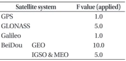
Table 1. values with satellite systems.
Satellite system F value (applied)
GPS 1.0
GLONASS 5.0
Galileo 1.0
BeiDou GEO 10.0
IGSO & MEO 5.0
Byung-Kyu Choi et al. Weighted Measurement Noise 207
𝑘𝑘 𝑘𝑘 𝑘𝑘 𝑘𝑘
𝑥𝑥̂
𝑘𝑘+1(−) = 𝑥𝑥̂
𝑘𝑘(+) + ∫
𝑡𝑡𝑡𝑡𝑘𝑘𝑘𝑘+1𝑓𝑓(𝑥𝑥̂
𝑘𝑘(+), 𝜏𝜏)𝑑𝑑𝜏𝜏
𝑃𝑃
𝑘𝑘+1(−) = Φ(𝑡𝑡
𝑘𝑘+1, 𝑡𝑡
𝑘𝑘)𝑃𝑃
𝑘𝑘(+)Φ(𝑡𝑡
𝑘𝑘+1, 𝑡𝑡
𝑘𝑘)
𝑇𝑇+ 𝑄𝑄
𝑘𝑘}
(2)where a state vector x
ˆ
k is composed of {𝑥𝑥, 𝑦𝑦, 𝑧𝑧, 𝑑𝑑𝑡𝑡, 𝐼𝐼𝐼𝐼𝐼𝐼𝐺𝐺𝐺𝐺𝐺𝐺𝐺𝐺, 𝑍𝑍𝑍𝑍𝑍𝑍, 𝐺𝐺𝑒𝑒𝑒𝑒𝑒𝑒𝑡𝑡, 𝐺𝐺𝑛𝑛𝑛𝑛𝑛𝑛𝑡𝑡ℎ, 𝑁𝑁𝐺𝐺𝐺𝐺𝐺𝐺𝐺𝐺1⋯ 𝑁𝑁𝐺𝐺𝐺𝐺𝐺𝐺𝐺𝐺𝑛𝑛}, and x, y, z refer to user position, dt refers to a receiver clock error, inter-system biases (ISB) refer to biases between different systems, Zenith Wet Delay (ZWD) refers to a tropospheric wet delay, 𝐺𝐺𝑒𝑒𝑒𝑒𝑒𝑒𝑡𝑡and 𝐺𝐺𝑛𝑛𝑛𝑛𝑛𝑛𝑡𝑡ℎ refer to gradient parameters in the troposphere, and 𝑁𝑁𝐺𝐺𝐺𝐺𝐺𝐺𝐺𝐺 refers to float ambiguities.
Furthermore, 𝑃𝑃𝑘𝑘 and 𝐾𝐾𝑘𝑘 indicate variance-covariance matrix and Kalman gain. 𝐻𝐻𝑘𝑘 refers to the design matrix, 𝑧𝑧𝑘𝑘 is an observables, and 𝑅𝑅𝑘𝑘 means the measurement noise matrix. In addition, Φ indicates the transition matrix, and 𝑄𝑄𝑘𝑘 is the system noise matrix.
2.2 Weighted Measurement Noise (WMN)
The currently operating four global satellite navigation systems employ different satellite orbits and clocks, and different frequencies with one another. Because of these different operating conditions, qualities of navigation signals received at the ground may be different. In addition, manufacturers of GNSS receivers employ different signal processing methods. Thus, high-precision data processing such as PPP is needed to take the weight on observation value into consideration. For example, it is generally set a large weight difference (approximately 100 times) to the code and carrier phase observations in the case of the GPS. In this study, Eq. (3) was used to consider a weight factor to the observations. Here, 𝑅𝑅𝑘𝑘 is applied to the process that calculates the Kalman gain in Eq. (1). Eq.
(3) does primary weighting according to the elevation angle of the satellite, and then secondary F factor is multiplied. Here, F is applied differently according to the navigation systems and satellite operation mode as presented in Table 1.
R
K= F
K× (1 SIN𝑒𝑒𝑒𝑒 ⁄ ) (3)
where 𝑒𝑒𝑒𝑒 is an elevation angle of the satellite.
The weight measurement noise (WMN) applied newly in this study affects BeiDou satellite observation data significantly. In the case of BeiDou GEO, 10.0 is applied to have 10 times difference of measurement noise compared to that of the GPS whereas 5.0 is applied to the Inclined Geosynchronous Orbit (IGSO) and Medium Earth Orbit (MEO). In addition, 5.0 is applied to GLONASS, which is the same as applied to the BeiDou MEO, and 1.0 is applied to Galileo, which is the same as applied to the GPS.
Furthermore, the Multi-GNSS PPP data processing performed in this study for verification according to the application of the WMN was carried out using the same method adopted by Choi et
(3)
where el is an elevation angle of the satellite.
The weight measurement noise (WMN) applied newly in this study affects BeiDou satellite observation data significantly. In the case of BeiDou GEO, 10.0 is applied to have 10 times difference of measurement noise compared to that of the GPS whereas 5.0 is applied to the Inclined Geosynchronous Orbit (IGSO) and Medium Earth Orbit (MEO). In addition, 5.0 is applied to GLONASS, which is the same as applied to the BeiDou MEO, and 1.0 is applied to Galileo, which is the same as applied to the GPS.
Furthermore, the Multi-GNSS PPP data processing performed in this study for verification according to the application of the WMN was carried out using the same method adopted by Choi et al. (2017).
3. RESULTS AND ANALYSIS
In this study, the positioning accuracy is analyzed to compare data processed results between a devised WMN method and results performed by Choi et al. (2017). Fig. 1 shows the change in the number of global navigation satellites received from the DAEJ GNSS reference station from 00:00 to 24:00 Universal Time on May 1, 2016. The number of GPS, GLONASS, and BeiDou satellites varies from 4 to 10 whereas Galileo satellites are received from 1 to 5. Many signals over the Korean Peninsula are sufficient to analyze not only Multi-GNSS PPP data processing, but also positioning performance.
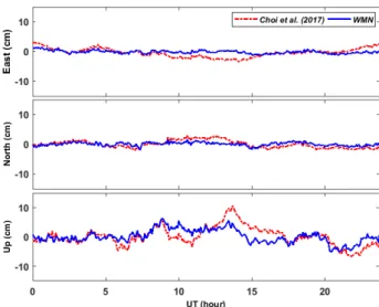
Fig. 2 shows the time-series of position errors at the DAEJ station that are calculated using double frequency
data obtained from the DAEJ station on May 1, 2016. For precise position of the DAEJ reference station, a solution from the Software INdependent EXchange provided by the International GNSS Service was assumed as a true value.
The red-colored dotted line marks the results calculated by Choi et al. (2017), and the blue-colored solid line indicates a position error estimated by applying the WMN method to Multi-GNSS PPP. A root mean square (RMS) of position error calculated by Choi et al. (2017) was 1.37, 1.16, and 2.66 cm in the east-west, south-west, and up-down directions, respectively. The RMS values by applying the WMN were 0.57, 0.60, and 2.29 cm, respectively. The above results indicated that RMS values of position error were reduced in the components of all directions after applying the WMN. In particular, positioning accuracy in the east-west direction was improved significantly to approximately 58.4%.
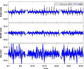
Multi-GNSS PPP data were processed using DAEJ GNSS data for 30 days from May 1 to 30, 2016 to verify the results.
Fig. 3 shows the time-series of position errors, calculated by applying Choi et al. (2017) and the WMN method, which are divided into the components in the east-west, south- north, and up-down directions. The gray-colored dotted line in Fig. 3 indicates the results by Choi et al. (2017), and the blue-colored solid line indicates the results by the WMN method. The positioning accuracy in the east-west direction was significantly improved after applying the WMN method as shown in Fig. 3. The detailed RMS values of position errors are listed in Table 2. The RMS values were reduced in all directions after applying the WMN method. In particular, the RMS value in the east-west direction was reduced sharply from 2.23 cm to 0.99 cm. On the contrary, the RMS Fig. 1. Visibility of GPS, GLONASS, Galileo and BeiDou satellites tracked at
‘DAEJ’ reference station in South Korea on May 1, 2016. Fig. 2. Comparison of positioning errors between Choi et al. (2017) and
WMN method. These results were derived from 3-pass filter of the Multi
GNSS kinematic PPP which uses dual-frequency data received at DAEJ
reference station on May 1, 2016.
208 JPNT 6(4), 205-210 (2017)
value in the up-down direction tended to decrease slightly from 3.93 cm to 3.73 cm.
Next, the WMN method was applied to both GPS(G) PPP and GPS+GLONASS+Galileo (G/R/E) PPP, and then the results were compared with the results of Multi-GNSS(G/R/
E/C) PPP. Fig. 4a shows the comparison of position errors calculated by G and G/R/E/C that integrates observables from different four satellite systems. The gray-colored dotted line indicates the result by G, and the red-colored solid line indicates the result by G/R/E/C. The RMS values of position errors calculated by G/R/E/C during this period were reduced more than that calculated by G in all directions.
The RMS values of position errors for each component with the data processing methods are described in Table 3. In particular, positioning accuracy in the east-west direction showed the largest improvement to approximately 36.9%
while those in the south-north and up-down directions were improved to 23.8% and 18.4%, respectively. The results in the present study were consistent with the results presented
by Li et al. (2015) who reported that positioning accuracy was improved by multi-GNSS PPP.
As shown in Fig. 4b, the comparison between combined G/R/E (marked by the gray-colored dotted line) PPP and G/R/E/C (marked by the red-colored solid line) PPP was conducted. It is to analyze the effect on the PPP to the BeiDou(C) system after applying the WMN method. The positioning accuracy was slightly improved in all directions with BeiDou(C) system to existing G/R/E. As described in Table 3, G/R/E/C had smaller RMS values in all directions than that of G/R/E. The positioning accuracy was improved by 15.4%, 7.7%, and 4.2% in the east-west, south-north, and up-down directions, respectively. As a result, when the BeiDou system was added to G/R/E, positioning accuracy was improved by approximately 9.1%. In contrast with the above result, Choi et al. (2017) recently reported that positioning accuracy was rather degraded when data of the Fig. 3. Comparison of kinematic PPP solutions between Choi et al. (2017)
and WMN method for DAEJ station. The gray-dot lines indicate the results derived from Choi et al. (2017). The results by WMN method are plotted with the blue lines.
Table 2. RMS values between Choi et al. (2017) and WMN method.
Method RMS (cm)
East North Up
Choi et al. (2017) WMN
2.23 0.99
1.51 1.09
3.93 3.73
Table 3. RMS values for G, G/R/E, and G/R/E/C kinematic PPP solutions with WMN method.
Method RMS (cm)
East North Up
G G/R/E G/R/E/C
1.57 1.17 0.99
1.43 1.18 1.09
4.57 3.89
3.73