ACCURACY ASSESSMENT BY REFINING THE RATIONAL POLYNOMIALS COEFFICIENTS(RPCs) OF IKONOS IMAGERY
SEUNG-CHAN LEE
Department of Earth System Sciences, Yonsei University 134 Sinchon-dong, Seodaemun-gu, Seoul 120-749, Korea
HYUNG-SUP JUNG, JOONG-SUN WON Department of Earth System Sciences, Yonsei University
Abstract: IKONOS 1m satellite imagery is particularly well suited for 3-D feature extraction and 1:5,000 scale topographic mapping. Because the image line and sample calculated by given RPCs have the error of more than 11m, in order to be able to perform feature extraction and topographic mapping, rational polynomial coefficients(RPCs) camera model that are derived from the very complex IKONOS sensor model to describe the object-image geometry must be refined by several Ground Control Points(GCPs). This paper presents a quantitative evaluation of the geometric accuracy that can be achieved with IKONOS imagery by refining the offset and scaling factors of RPCs using several GCPs. If only two GCPs are available, the offsets and scale factors of image line and sample are updated. If we have more than three GCPs, four parameters of the offsets and scale factors of image line and sample are refined first, and then six parameters of the offsets and scale factors of latitude, longitude and height are updated. The stereo images acquired by IKONOS satellite are tested using six ground points. First, the RPCs model was refined using 2 GCPs and 4 check points acquired by GPS. The results from IKONOS stereo images are reported and these show that the RMSE of check point acquired from left images and right are 1.021m and 1.447m. And then we update the RPCs model using 4 GCPs and 2 check points. The RMSE of geometric accuracy is 0.621 m in left image and 0.816m in right image.
Keywords
:IKONOS, RPCs, offset, scaling factors
1. Introduction
The IKONOS camera model has been described by Rational Polynominal Coefficient(RPC) equations. RPC models have become the replacement model of choice for a number of high-resolution satellite imagery provider. RPCs provide a simple, efficient, and accurate representation of the camera object-image geometry and allow the end-user to perform full photogrammetric processing of satellite imagery including block adjustment, 3D feature extraction and orthorectification[1].
RPC equations from Space Imaging ground stations are fit to the physical camera model after block
adjustment and so have the absolute accuracy resulting from that block adjustment. IKONOS accuracy has been evaluated by the deviations from the RPC model[2], [3], [4]. Yet due to the presence of biases in the sensor exterior orientation which are primarily due to the attitude errors, geopositioning via RPCs carries specifications for IKONOS imagery that indicates an absolute accuracy which is well below the inherent relative positioning capacity of the imaging system. The inclusion of GCPs should once again offer the potential of facilitating a practical means of enhancing geopositioning accuracy to the one pixel and better[5].
In order to refine the RPC model, we use the latitude, longitude, height, sample and line offsets and scale factors. Using two GCPs, sample and line offsets and scale factors are updated and all of parameters are updated when refined with more than five GCPs.
In our study, we use stereo pair of IKONOS images acquired by In-track stereo and 6 GCPs by GCP survey around Daegu area. The accuracy is within 1m and influenced by the quality of GCPs.
Theory of RPC model is presented in section 2. In section 3 and 4, we show the test data and results.
Conclusions follow them in section 5.
2. Theory
The Rational Polynominal Coefficient(RPC) model relates the object space(latitude, longitude, height) coordinates to image space (line, sample) coordinates.
The RPC functional model is of the form of a ratio of two cubic functions of object space coordinates.
The line RPC model is given as
) , , (
) , , (
W V U Den
W V U l Num
L
=
L(1) where
3 20 2 19 2 18 2 17 3 16 2 15
2 14 2 13 3 12 11
2 10 2 9 2 8
7 6 5 4 3 2
) 1
, , (
W a W U a W V a W V a U a U V a
W V a U V a V a W V U a W a U a V a
W U a W V a U V a W a U a V a a W V U NumL
⋅ +
⋅
⋅ +
⋅
⋅ +
⋅
⋅ +
⋅ +
⋅
⋅ +
⋅
⋅ +
⋅
⋅ +
⋅ +
⋅
⋅
⋅ +
⋅ +
⋅ +
⋅ +
⋅
⋅ +
⋅
⋅ +
⋅
⋅ +
⋅ +
⋅ +
⋅ +
=
3 20 2 19 2 18 2 17 3 16 2 15
2 14 2 13 3 12 11
2 10 2 9 2 8
7 6 5 4 3 2
) 1
, , (
W b W U b W V b W V b U b U V b
W V b U V b V b W V U b W b U b V b
W U b W V b U V b W b U b V b b W V U DenL
⋅ +
⋅
⋅ +
⋅
⋅ +
⋅
⋅ +
⋅ +
⋅
⋅ +
⋅
⋅ +
⋅
⋅ +
⋅ +
⋅
⋅
⋅ +
⋅ +
⋅ +
⋅ +
⋅
⋅ +
⋅
⋅ +
⋅
⋅ +
⋅ +
⋅ +
⋅ +
=
Likewise the sample RPC model is expressed as
) , , (
) , , (
W V U Den
W V U s Num
S
=
S(2) where
3 20 2 19 2 18 2 17 3 16 2 15
2 14 2 13 3 12 11
2 10 2 9 2 8
7 6 5 4 3 2
) 1
, , (
W c W U c W V c W V c U c U V c
W V c U V c V c W V U c W c U c V c
W U c W V c U V c W c U c V c c W V U NumS
⋅ +
⋅
⋅ +
⋅
⋅ +
⋅
⋅ +
⋅ +
⋅
⋅ +
⋅
⋅ +
⋅
⋅ +
⋅ +
⋅
⋅
⋅ +
⋅ +
⋅ +
⋅ +
⋅
⋅ +
⋅
⋅ +
⋅
⋅ +
⋅ +
⋅ +
⋅ +
=
3 20 2 19 2 18 2 17 3 16 2 15
2 14 2 13 3 12 11
2 10 2 9 2 8
7 6 5 4 3 2
) 1
, , (
W d W U d W V d W V d U d U V d
W V d U V d V d W V U d W d U d V d
W U d W V d U V d W d U d V d d W V U DenS
⋅ +
⋅
⋅ +
⋅
⋅ +
⋅
⋅ +
⋅ +
⋅
⋅ +
⋅
⋅ +
⋅
⋅ +
⋅ +
⋅
⋅
⋅ +
⋅ +
⋅ +
⋅ +
⋅
⋅ +
⋅
⋅ +
⋅
⋅ +
⋅ +
⋅ +
⋅ +
=
where again Num
sand Den
sare cubic functions of object space coordinates, U , V , and W are normalized object space coordinates (latitude, longitude, height), and l and s are normalized image space coordinates(line, sample).
IKONOS RPCs, comprising 78 rational polynominal coefficients, { a
1K a
20, b
2K b
20, c
1K c
20, d
2K d
20}alongside 10 scale and offset factors, are provided.
Fig. 1. IKONOS stereo viewing.
The RPC functional model is a ratio of two cubic polynominals of object space coordinates, and as such provides a functional relationship between the object space ( φ , λ , h ) coordinates and the image space ( L, S ) coordinates. Separate rational functions are provided for mapping the object space coordinates to line and sample coordinates, respectively. To improve numerical precision, image and object space coordinates are normalized to <-1, +1> range by applying the offsets and the scale factors as shown below:
, ,
,
s o s
o s
o
h h W h
V
U = − = − = −
λ λ λ φ
φ φ
s o
S S s = S − and
s o
L L
l = L − (3)
where φ is geodetic longitude, h is height above the ellipsoid, S and L are the image sample and line coordinates, φ
o, λ
o, h
o, S
o, L
o, φ
s, λ
s, h
s, S
s, L
sare the latitude, longitude, height, sample and line offsets and scale factors.
φ
o, λ
o, h
o, S
oand L
oare the mean values.
∑
= 1 φ ,
φ
on λ
o= 1 n ∑ λ , h
o= 1 n ∑ h ,
∑
= 1 ,
n S
S
oand L
o= 1 n ∑ L , (4)
φ
s, λ
s, h
s, S
sand Ls are the sclae factors.
(
o o)
s
φ φ φ φ
φ = max
max− ,
min−
(
o o)
s
λ λ λ λ
λ = max
max− ,
min−
(
o o)
s
h h h h
h = max
max− ,
min−
(
o o)
s
S S S S
S = max
max− ,
min−
(
o o)
s
L L L L
L = max
max− ,
min− (5) 1) Refining RPC model
In order to refine the RPC model, we use the latitude, longitude, height, sample and line offsets and scale factors in Eq. (3).
If only two GCPs must be used, then sample and line offsets and scale factors of S
o, S
s, L
oand L
sare updated.
First, if only two GCPs must be used, then sample and line offsets and scale factors of S
o, S
s, L
oand L
sare updated.
The normal equation is represented as follow,
i s i
s i s i
l
s s
l l S S L L a a
a a v
v ⎥
⎦
⎢ ⎤
⎣
⎡
−
= −
⎥ ⎥
⎥ ⎥
⎦
⎤
⎢ ⎢
⎢ ⎢
⎣
⎡
⎥ ⎦
⎢ ⎤
⎣
= ⎡
⎥ ⎦
⎢ ⎤
⎣
⎡
0 0 0 0
24 23 12
11
0 0
0
0 (6)
Where,
LS
a 1
11=−
,
20 12
LS
L a =−L−
,
SS
a 1
23=−
and
2 0 24
SS
S a =−S−
.
If we have more than three GCPs, latitude, longitude and height offsets and scale factors are updated, too.
i s i
i s i
l
s s
l l h a a a
a v
v ⎥
⎦
⎢ ⎤
⎣
⎡
−
= −
⎥ ⎥
⎥ ⎥
⎦
⎤
⎢ ⎢
⎢ ⎢
⎣
⎡
⎥ ⎦
⎢ ⎤
⎣
= ⎡
⎥ ⎦
⎢ ⎤
⎣
⎡
0 0 0
26 16 21
11
...
...
...
...
...
...
λ
(7)
We can rewrite equation (7) as
= 0 +
∆
+ B E
v
s s(8)
where, v is misclosure vector, B
sis design matrices composed of partial derivatives, ∆
sis vector of unknown parameters, and E is residuals vector of the observations.
U
s
= N
−1∆ (9)
where, N and U is represented as
S T S
B B
N = , U = − B
TE (10)
To obtain a better solution, we must use the iterations in equation (8), (9) and (10).
3. Test Data
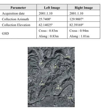
We use the stereo pair of IKONOS images acquired by In-track stereo and 6 GCPs by GCP survey around Daegu area. IKONOS image parameters are summarized in Table1.
Table 1. The imaging parameters of IKONOS stereo pair.
Parameter Left Image Right Image Acquisition date 2001.1.10 2001.1.10 Collection Azimuth 25.7400° 129.9007°
Collection Elevation 62.14025° 82.39169°
GSD Cross : 0.83m
Along : 0.83m
Cross : 0.94m Along : 1.01m
Fig. 2. IKONOS image and 6 ground points. Ground points are used to test refining RPCs method.
4. Result
We refined model in two ways. First, using 2 GCPs and 4 check points, the results show that the RMSE of
check point acquired from left images and right are 1.021m and 1.447m, respectively. And then using 4 GCPs and 2 check points, the RMSE of geometric accuracy is 0.621 m in left image and 0.816m in right image. The RMSE of check points is displayed in Table 2 and 3.
Table 2. RMSE of check points. (2 GCPs, 4 check points) Ex is RMSE in line direction, Ey is RMSE in sample direction
and Et means Total RMSE.: L means left image, R means right image.
No Ex Ey Et
Check points(L) 4 0.719m 0.724m 1.021m Check points(R) 4 1.338m 0.550m 1.447m
Table 3. RMSE of check points. (4 GCPs, 2 check points)
No Ex Ey Et
GCPs(L) 4 0.436m 0.464m 0.637m Check points(L) 2 0.611m 0.112m 0.621m GCPs(R) 4 0.721m 0.363m 0.807m Check points(R) 2 0.814m 0.048m 0.816m
5. Conclusions
The ground-to-image relationship of IKONOS images is described by the nominal RPC model. In order to be able to perform feature extraction and topographic mapping, rational polynomial coefficients(RPCs) camera model must be refined by several Ground Control Points(GCPs). We are not concerned with 78 rational polynomial coefficients, but 10 scales and offset factors.
Generally, because the given errors are in proportion to line and pixel counts, the offsets and scale factors of sample and line are firstly updated. And then, the offsets and scale factors of latitude, longitude and height are refined. The results acquired by these methods show that feature extraction and topographic mapping can be performed.
Reference
[1] Grodecki, J., and Gene, D., 2001, Mathematical Model for 3D Feature Extraction from Multiple Satellite Images Described by RPCs, Proceedings of ASPRS, In Denver.
[2] Tao, C. Vincent and Yong Hu, 2001, A Comprehensive Study of the Rational Function Model for Photogrammetric Processing, PE&RS, 67(12):1347-1357.
[3] Grodecki, J., and Gene, D., 2001, Block Adjustment of High-Resolution Satellite Images Described by Rational Polynominals, PE&RS, 69(1):59-68.
[4] Dial, G and Jacek, G., 2002, IKONOS Accuracy Without Ground Control, Proceedings of ISPRS, In Denver.
[5] Fraser, C.S, Harry, B.H, and Takeshi, Y., 2002, Three- Dimensional Geopositioning Accuracy of IKONOS Imagery, Photogrammetric Record, 17(99):465-479.