자율주행 지원을 위한
고해상도 무인항공 영상처리 기반의 도로정보 추출
이근왕
청운대학교 멀티미디어학과
Extraction of Road Information Based on High Resolution UAV Image Processing for Autonomous Driving Support
Keun-Wang Lee
Department of Multimedia Science, Chungwoon University
요 약 최근 자율주행 자동차 기술의 발전으로 정밀도로지도에 대한 중요성이 증가하고 있다. 정밀도로지도는 차선 정보, 규제·안전 정보, 각종 도로 시설물 등이 표현된 디지털 지도로 MMS(Mobile Mapping System) 기반으로 시험 제작되어 왔지 만 이 방법은 고가의 도입비용으로 크게 활성화되지 못하고 있다. 하지만 무인항공기의 경우 적용 분야가 지속적으로 늘어나 고 있으며, 이에 대한 연구도 다양한 분야에서 이루어지고 있다. 본 연구에서는 고해상도 무인항공기 영상의 처리를 통해 자율주행에 필요한 차선, 시설물 등의 정보를 추출하고자 하였다. 자율주행 자동차 시험도로를 연구대상지로 선정하고, 무인 항공기를 이용하여 고해상도 정사영상을 제작하였다. 기존의 수치지형도와 정밀도로지도의 속성비교를 통해 정밀도로지도 제작을 위한 차선, 중앙분리대, 제어기 등의 추출 항목을 선정하였다. 또한 영상분류를 통해 차선, 중앙분리대, 제어기 등 정밀도로지도 구축을 위한 데이터를 효과적으로 추출함으로써 고해상도 정사영상의 활용성을 제시하였다. 추가적인 실험과 검증을 통해 무인항공기 영상의 이용 분야를 확대할 수 있을 것이며, 구축된 데이터를 자동차 제작사 및 관련 민·관 기관, 벤처 기업 등에 제공한다면 국내 자율주행차 기술 발전에 기여할 것이다.
Abstract Recently, with the development of autonomous vehicle technology, the importance of precise road maps is increasing. A precise road map is a digital map with lane information, regulations, safety information, and various road facilities. Conventional precise road mapshavebeen tested and developed based on the mobile mapping system (MMS). But they havenot been activated due to high introduction costs. However, in the case of unmanned aerial vehicles (UAVs), the application field is continuously increasing. This study triesto extract information through classification of high-resolution UAV images for autonomous driving. Autonomous vehicle test roads were selected as study sites, and high-resolution orthoimages were produced using UAVs. In addition, the utilization of high-resolution orthoimages has been proposed by effectively extracting data for precise road map construction, such as road lines, guards, and machines through image classification. If additional experimentation and verification are performed, the field of UAV image use will be expanded, providing the data to automobile manufacturers and related public and private organizations, and venture companies will contribute to the development of domestic autonomous vehicle technology.
Keywords : Autonomous Driving, Image Classification, Ortho Image, Precise Road Map, UAV
*Corresponding Author : Keun-Wang Lee(Chungwoon University) Tel: +82-32-770-8203 email: [email protected]
Received July 24, 2017 Accepted August 17, 2017
Revised August 14, 2017 Published August 31, 2017
1. 서론
정밀도로지도는 차선 정보, 규제·안전 정보, 각종 도 로 시설물 등이 표현된 디지털 지도로 최근 자율주행차 기술이 지도 기반 추세로 발전함에 따라 중요성이 커지 고 있다[1-5]. 국토교통부 국토지리정보원은 2015년부터 정밀도로지도의 구축 항목, 방법, 기술 등에 대한 기초 연구와 시범구축을 착수하였으며, 구축된 결과를 관련 민간 기업, 연구기관 등 약 40여 기관, 기업에 제공하여 자율주행 기술 개발 등을 지원하고, 2020년까지 자율주 행 자동차의 상용화 지원방안으로 전국 고속도로 및 4차 선 이상 국도의 정밀도로지도를 구축한다는 계획을 추진 하고 있다[6-8]. 최근 도로지도 구축을 위한 연구로 MMS(Mobile Mapping System)을 활용한 DB 구축이 이루어지고 있다[9]. MMS는 3D 레이저스캐너, 디지털 카메라, IMU(Inertial Measurement Unit), DMI(Distance Measuring Indicator) 등의 센서를 통합하여 빠르게 공 간정보를 취득할 수 있도록 개발된 시스템이다[10,11].
하지만 고가의 도입비용으로 인해 아직 관련 산업분야에 적용이 활성화되고 있지 못하고 있는 실정이다. 반면 무 인항공기는 영상의 촬영, 지도제작, 공간정보 구축 등 다 양한 분야에 적용되어 관련 시장이 빠르게 성장하고 있 다[12-13]. 특히, 대상지역이 넓지 않은 경우, 공간정보 취득의 경제성과 신속성 때문에 많은 주목을 받고 있으 며, 최근 빠르게 성장하고 있는 정보통신기술과의 융합 은 관련 산업 발전에 큰 영향을 미치고 있다[14].
Fig. 1. Study Flow Chart
본 연구에서는 무인항공기를 이용하여 연구대상지역 에 대한 정밀 정사영상을 제작하고, 영상분류 기법을 적 용하여 차선, 도로분리대, 도로주변 식생과 같은 자율주 행을 위한 정보추출을 수행하고자 하였다. 2장에서는 정 사영상 제작을 위한 데이터 취득과 처리 과정을 기술하 며, 3장에서는 생성된 정사영상의 분류 및 이에 대한 분 석을 기술한다. 그림 1은 본 연구의 연구 흐름도를 나타 낸다.
2. 데이터 취득 및 정사영상 생성
본 연구에서는 정밀도로지도 구축을 위한 도로정보의 추출을 위해 고해상도 정사영상을 활용하고자 하였다.
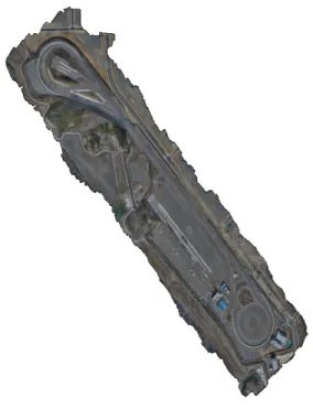
연구대상지는 대구지역에 위치한 자율주행자동차 시험 도로를 선정하였으며, 무인항공기를 이용하여 대상지역 의 영상을 취득하였다.
대상지역의 면적은 약 1km2이며, 비행고도 150m로 영상을 취득하였다. 비행은 25분씩 2회 수행하였으며, 취득된 영상은 총 1,100매였다. 그림 3은 비행경로를 나 타낸다.
Fig. 2. Study area
정사영상은 접합점 추출, GCP(Ground Control Point) 입력, DSM(DIgital Surface Model)생성, 영상 모자이크 의 처리과정을 통해 생성하였으며, TBC(Trimble Bussiness Center) 소프트웨어를 활용하였다. 그림 4는 자료처리 화면을 나타낸다.
Fig. 4. Data processing screen
자료처리를 통해 지상해상도 2cm급의 정사영상을 제 작하였다. 그림 5는 DSM이며, 그림 6은 정사영상을 나 타낸다.
Fig. 5. DSM
Fig. 6. Ortho image
3. 영상분류
항공사진이나 위성영상 등 다양한 레스터 형태의 자 료는 광역적인 토지피복 모니터링, 대기 오염 모델링, 홍 수 및 산사태 등의 재해평가 등 다양한 분야에 이용되어 왔다. 주로 시계열적인 영상자료를 활용한 광역 변화탐 지 및 모니터링과 같은 분야에 주로 활용이 되어 왔다.
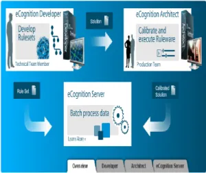
하지만 영상분류는 사용자의 숙련도에 따라 성과물의 품 질이 결정되며, 많은 시간과 노력을 필요로 한다. 본 연 구에서는 eCognition 소프트웨어를 영상분류에 이용하 였다.
eCognition은 객체 기반 방식의 영상분류 소프트웨어 로서, 객체 기반 방식의 우수한 컨텍스트 이미지 분석 기 능을 제공한다. 또한 객체분할 처리를 통한 다량의 고해 상도 이미지의 쉽고 빠른 분석을 지원하여, 공간정보에 대한 효율적인 처리가 가능하여 다양한 분야에서 활용되 고 있다. 그림 7은 eCognition의 구성을 나타낸다[15].
Fig. 7. Components of eCognition
본 연구에서는 무인항공기를 통해 생성한 고해상도 정사영상을 이용하여 정밀도로지도 구축을 위한 도로정 보를 추출하였다. 먼저 정밀도로지도 구축에 필요한 정 보의 선정을 위해 기존 수치지형도와 정밀도로지도의 속 성을 조사하였다. 그림 8은 수치지형도와 정밀도로지도 의 속성 비교를 나타낸다.
Fig. 8. Comparison of properties with digital map and precise road map
기존 수치지형도와 자율주행 지원을 위한 정밀도로지 도의 속성 비교를 통해 정사영상에서의 추출항목을 차 선, 중앙분리대, 식생, 제어기 등으로 선정하였다. 그림 9 는 분류항목을 나타낸다.
Fig. 9. Classification items
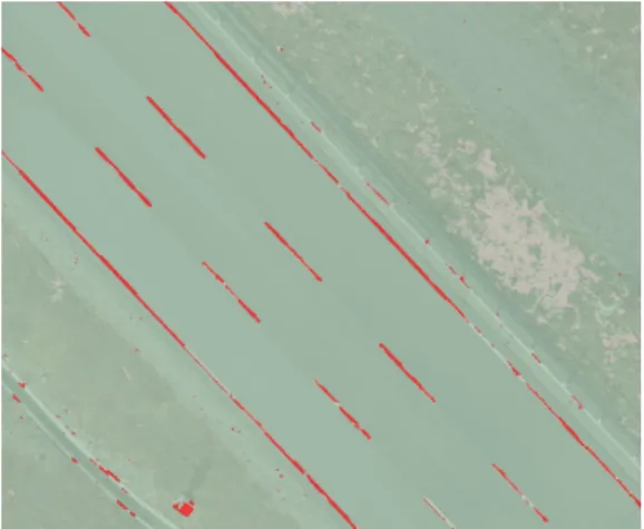
각 항목의 분류를 위해 정사영상의 일부지역을 선정 하여 영상의 색상정보를 활용한 룰셋을 작성하고, 객체 기반의 자동분류 알고리즘을 적용시켜 자동분류를 수행 하였다. 그림 10은 영상분류 지역이며, 그림 11~그림 13 은 각 항목에 대한 분류 결과를 나타낸다.
Fig. 11. Classification result – road line
Fig. 12. Classification result – tree
Fig. 13. Classification result – guard, machine
무인항공기를 이용한 고해상도 정사영상을 이용하여 그림 11~그림 13에 보는 바와 같이 정밀도로지도 구축 을 위한 차선, 중앙분리대, 제어기 등의 속성정보를 효과 적으로 추출할 수 있었다. 이러한 결과는 무인항공기 정 사영상을 이용한 정밀도로정보 구축의 가능성을 제시하 는 것이다. 또한 지속적인 연구를 통해 도로 정보의 유실 점검이나 도로의 파손 여부 모니터링과 같은 분야에 활 용 가능성을 검증한다면 무인항공기 정사영상의 이용 분 야를 확대할 수 있을 것이며, 구축된 데이터를 자동차 제 작사 및 관련 민·관 기관, 벤처 기업 등에 제공한다면 국 내 자율주행차 기술 발전에 기여할 수 있을 것이다.
4. 결론
본 연구는 고해상도 무인항공기 영상의 처리를 통해 자율주행을 위한 정보를 추출하고자 한 것으로 다음과 결론을 얻었다.
1. 무인항공기를 이용하여 연구대상지역에 대해 지상 해상도 2cm급의 고해상도 정사영상을 제작할 수 있었다.
2. 기존의 수치지형도와 정밀도로지도의 속성비교를 통해 정밀도로지도 제작을 위한 차선, 중앙분리대, 제어기 등의 추출 항목을 선정하였다.
3. 객체기반 영상분류 기법을 이용하여 정밀도로지도 구축을 위한 항목들을 효과적으로 추출함으로써 고해상도 정사영상을 이용한 도로정보 추출의 활 용성을 제시하였다.
4. 추가적인 실험과 검증을 통해 무인항공기 정사영 상의 이용 분야를 확대할 수 있을 것이며, 구축된 데이터를 자동차 제작사 및 관련 민·관 기관, 벤처 기업 등에 제공한다면 국내 자율주행차 기술 발전 에 기여할 것이다.
References
[1] S. C. Oh, K. H. Kim, H. Y. Choi, “Train interval control and train-centric distributed interlocking algorithm for autonomous train driving control system”, Journal of the Korea Academia-Industrial cooperation Society, vol. 17, no. 11, pp. 1-9, 2016.
DOI: http://dx.doi.org/10.5762/KAIS.2016.17.11.1
[2] D. H. Nam, S. S. Lee, N. S. Kim, “Issue-Tree and QFD Analysis of Transportation Safety Policy with Autonomous Vehicle”, The Journal of The Korea Institute of Intelligent Transport Systems, vol. 15, no.
4, pp. 26-32, 2016.
DOI:http://dx.doi.org/10.12815/kits.2016.15.4.026 [3] Bo Ram Gu, Da Young Ju, "Interaction Characteristics
of Autonomous Driving Levels from User Perspective", Asia-pacific Journal of Multimedia Services Convergent with Art, Humanities, and Sociology, Vol. 7, No. 2, pp. 351-359, Feb. 2017.
DOI: http://dx.doi.org/10.14257/AJMAHS.2017.02.70 [4] Joon sung Kim, "The Legal Probability as Causal
Responsibility founded on the Probabilistic Theory of Causality: On the Legal Responsibility of Autonomous Vehicles", Asia-pacific Journal of Multimedia Services Convergent with Art, Humanities, and Sociology, Vol.
6, No. 12, pp. 587-594, Dec. 2016.
DOI: http://dx.doi.org/10.14257/AJMAHS.2016.12.58 [5] Yun-Gil Lee, "A Basic Study on the Development of
Autonomous Behavioral Agent based on Ontology Used in Virtual Space", Asia-pacific Journal of Multimedia Services Convergent with Art, Humanities, and Sociology, Vol. 7, No. 6, pp. 777-784, June 2017.
DOI: http://dx.doi.org/10.14257/ajmahs.2017.06.46 [6] Ministry of Land, Infrastructure and Transport, ‘Precise
Road Map’ Advance Commercialization of Autonomous Vehicles, Available From
http://www.molit.go.kr (accessed Aug. 2, 2017) [7] National Geographic Information Institute, ‘Precise Road
Map’ Advance Commercialization of Autonomous Vehicles, Available From http://www.ngii.go.kr/.
(accessed Aug. 2, 2017)
[8] Kiljae, Ahn, Yongsung Kim, "Basic Study of Architectural Design Using low-cost, low-altitute photogrammertric system", Asia-pacific Journal of Multimedia Services Convergent with Art, Humanities, and Sociology, Vol. 5, No. 4, pp.789-796, Aug. 2015.
DOI: http://dx.doi.org/10.14257/AJMAHS.2015.08.54 [9] J. E. Kim, C. H. Hong, “(A) study on location correction
method of indoor/outdoor 3D model through data integration of BIM and GIS”, Journal of the Korea Academia-Industrial cooperation Society, vol. 18, no. 3, pp. 56-62, 2017.
DOI:http://dx.doi.org/10.5762/KAIS.2017.18.3.56 [10] Y. S. Jwa, G. H. Sohn, J. U. Won, W. C. Lee, N. Y.
Song, “Railway Track Extraction from Mobile Laser Scanning Data”, Journal of the Korean Society of Surveying, Geodesy, Photogrammetry and Cartography, vol. 33, no. 2, pp. 111-122, 2015.
DOI:http://dx.doi.org/10.7848/ksgpc.2015.33.2.111 [11] E. J. Yoo, D. C. Lee, “Determination of Physical
Footprints of Buildings with Consideration Terrain Surface LiDAR Data”, Journal of the Korean Society of Surveying, Geodesy, Photogrammetry and Cartography, vol. 34, no. 5, pp. 503-514, 2016.
DOI:http://dx.doi.org/10.7848/ksgpc.2016.34.5.503 [12] B. J. Kang, H. C. Cho, “System of Agricultural Land
Monitoring Using UAV”, Journal of the Korea Academia-Industrial cooperation Society, vol. 17, no. 6,
[13] Young Jin Park, Min Gyu Kim, "Analysis of Characteristics of Ortho Image by Type of Terrain Model using Unmanned Aerial Vehicle", Asia-pacific Journal of Multimedia Services Convergent with Art, Humanities, and Sociology, Vol. 5, No. 5, pp. 505-513, Oct. 2015.
DOI: http://dx.doi.org/10.14257/AJMAHS.2015.10.37“
[14] K. R. Lee and W. H. Lee, “Orthophoto and DEM Generation Using Low Specification UAV Images from Different Altitudes”, Journal of the Korean Society of Surveying, Geodesy, Photogrammetry and Cartography, vol. 34, no. 5, pp. 535-544, 2016.
DOI: http://dx.doi.org/10.7848/ksgpc.2016.34.5.535 [15] Trimble, Imaging Software Suites, Available From
http://www.trimble.com (accessed Aug. 2, 2017)
이 근 왕(Keun-Wang Lee) [종신회원]
• 1993년 2월 : 한밭대학교 전자계 산학과 (공학사)
• 1996년 2월 : 숭실대학교 컴퓨터 공학과 (공학석사)
• 2000년 2월 : 숭실대학교 컴퓨터 공학과 (공학박사)
• 2001년 3월 ~ 현재 : 청운대학교 멀티미디어학과 교수
<관심분야>
컴퓨터 통신, 멀티미디어 통신, 멀티미디어 응용