지형정보시스템을 활용한 생태학적인 폐광지역 재개발 계획 및 관리
이주영1,2·한무영2·양중석1·최재영1*
1한국과학기술연구원강릉분원천연물소재센터
,
2서울대학교건설환경공학부A Strategic Plan and Management for Ecological Abandoned Mine Land (AML) Reuse Using GIS
Ju Young Lee1,2·Moo Young Han2·Jung-Seok Yang1·Jaeyoung Choi1*
1
Natural Products Center, KIST-Gangneung
2
Department of Civil and Environmental Engineering, Seoul National University
ABSTRACT
Plan and management for Ecological Abandoned Mine Lands (AMLs) reuse using Geographic Information System (GIS) technique are an ideal method. GIS technique display, manage and analyze a spatially referenced data, which can be combined in user-defined ways to make plan and decision about AMLs reuse. Local communities are affected by AMLs.
In the past, plan and management of AMLs have never been considered for ecological aspects as well as using GIS.
However, the rapidly growing GIS technology have proven to be a valuable tool in the process of understanding environment and of making responsible environmental decisions. This paper suggests that making responsible decision and plan using GIS can create a various types of benefits to local communities. This also shows that GIS may play a vital role at the decision/planning process of analysis and exploration of local environmental situation. We are trying to apply to decision support system for AMLs reuse. Moreover, a lot of thematic maps are making using GIS providing a comprehensive data with images. These can be an ideal platform to deliver meaningful outcomes.
Keywords: Decision making, System, Tool
요 약 문
폐광지역은 경제적 측면에서 낙후된 지역이며
,
무엇보다도폐광개발로 인한 주변생태계 파괴는 우려할만한수준에이르고 있다
.
폐광산은지형적인 관점에서 접근성이용이하지 않으며그곳에서 유출되는폐광배수는하천과지하수 로유입되어서 지역주민들건강에위협을주고있는 실정이다.
특히강원도일부지역에서는이러한현상으로지역 주민들이 고통을겪고 있으며무엇보다도폐광후의 경제적낙후현상이심해지고 있는 실정이다.
기술적인 폐광지역복원은이미 많은 기술보고서와논문을통해 알려져있다
.
하지만많은 기술적인노하우가 축적되어있어도계획단 계와 관리단계가제대로되지않으면경제적손실 뿐만아니라지역주민의불만을오히려유발시킬수있다.
따라서 본 연구의목적은폐광지역의생태학적재이용측면을고려하여 효율적인 계획과관리모델을제시하고자한다.
특히지형정보시스템
(Geographic Information System)
의정책결정단계에적용함으로써 경제적가치,
환경적가치 그리 고 공익적가치 창출에크게 이바지할수있다.
주제어: 지형정보시스템
,
폐광지역*Corresponding author : [email protected]
원고접수일
: 2007. 5. 9
심사일: 2007. 6. 5
게재승인일: 2008. 9. 12
질의및토의
: 2008. 12. 31
까지*
본논문은2007
년춘계학술발표회특별호논문입니다.
2
이주영·한무영·양중석·최재영1. Introduction
Gangwon province has discussed possible regional cooperation for Abandoned Mine Discharge (AMD) management for over 20 years, and begun joint efforts for government legislation, local government funding, planning and management sharing. Recently, AMD has made many problems including ecological or environmental destruction and human health damage. Despite the expenditure of billion Won to prevent AMD and control flow from upstream to downstream. Recently, local people keep complaining to local government about soil and water contamination.
Also, extreme climatic phenomena have frequently occurred in recent years due to a climate change as well as geological complicates with many abandoned mines. Local government leaders and officers have higher awareness about these problems as well as ecological and health risks for local communities.
Therefore, the effective plan and management techniques are needed
For AMLs reuse, decision makers and engineers should understand complex environmental issues, evaluate proposed environmental plan and law, and how individual decisions affect the local to global scales (Pfirman and AC-ERE, 2003). Recently, environmental problems such as AMD have multiple causes and multiple effects. Such complex problems causes climate change, variability and geological complexity. Known as “cognitive flexibility” and the understanding complexity of AMD problem will help for solution (Spiro and Jehng, 1990). The understanding of complexity requires a variety of data collection and analysis.
The GIS technique has played an important role in understanding the environmental complexity and making decisions for environmental issues (Carrarra and Fausto, 1995; Heit et al., 1991). However, the GIS application for AMLs reuse has not been applied yet. Recently, our group and Mine Reclamation Corp. (MIRECO) actively promote a better understanding of hazardous potential of abandoned mine through the use of GIS.
GIS technology has already proven to be an extremely
powerful tool in decision makers and raising public awareness for environmental management.
Mitigating the effects of abandoned mine hazards, providing potential risk analysis and ecological abandoned mine reuse for local communities are a useful application area. Furthermore, GIS transcends interdis- ciplinary field such as environmental, ecological, and social science by integration and combination data.
Then using AMD maps and natural habitats maps through GIS in inquiry-based investigation and evaluation, decision makers and environmental planners use evidence and practices in the same manner as engineers.
This paper can be served over GIS to make decision and action plan for AML reuse. Also, GIS can be used to track how ecological system and human habitats are changing in response to AML reuse. The most important thing is that this paper provide a framework for integration of environmental, ecological, and social data across a range of temporal and spatial scales. In addition, this helps decision makers and developers integrate interdisciplinary perspectives.
2. Identification of benefits and constraints
Ecological abandoned mine reuse should consider
benefits and constraints at the planner's point of view
such as plan and management for environmental,
economic and public aspects. These can gain
advocates such as government leaders, environmental
policy makers, local communities and community
stakeholders. The understanding benefits and constraints
for redeveloping AML can allow the incorporation of
ecological enhancements. Benefits should contribute to
many groups such as local industries, local communities,
and regulatory. Even though benefits are assigned to
local communities in aspects of environmental, economic
and public, there are also constraints, which have
unexpectedly caused public concerns. Then, the plan
should carefully set up. The AML reuse plan is the
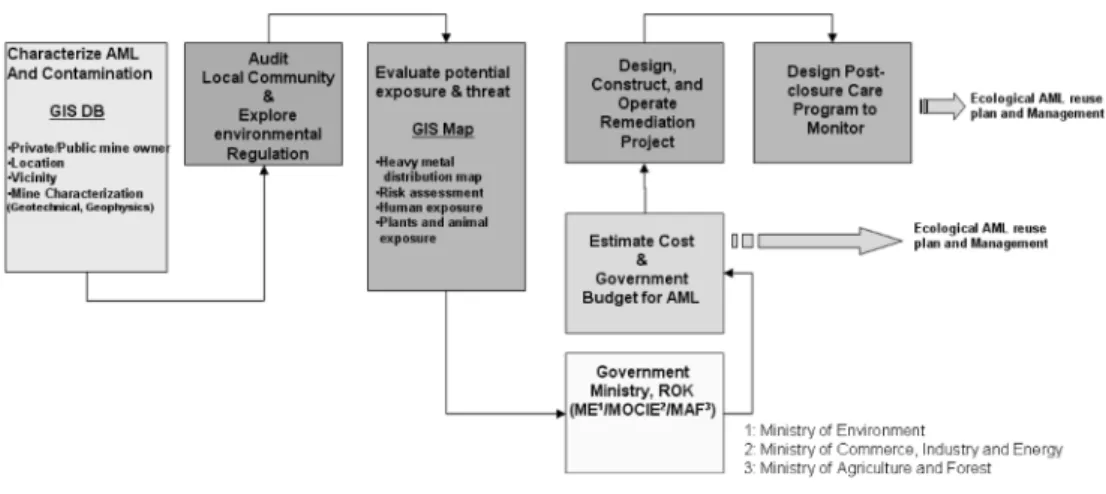
last step after an AML remedial work. At first,
remedial plan is simply referred in Fig. 1.
2.1. What is environmental benefits?
Recreating an ecological AML provides environ- mental benefits to soil, water, plant and animal as well as human health. Gangwon province has the mountain ridge. There are well preserved beautiful valleys and mountains make it a most favorite tourist attraction and only a clean area in South Korea.
Unfortunately, serious environmental problems are brought about by derelict mines. Then, ecological abandoned mine reuse should be necessary and their results will give birth to many environmental benefits.
These benefits are described below:
1) Preserves wildlife and improves plants diversity 2) Provides recreational areas
3) Reduces mine tailing and sediment with heavy metals 4) Improves surface water quality
5) Improves ground-water quality 6) Improves aesthetics
Specially, these benefits refer to recreational and natural conservational activities that do not require prepared facilities like wildlife viewing, camping, walking, picnicking, running/jogging, fishing and observing and photographing nature. Ecosystem service benefits can provide tourists and local communities. While local government such as Gangwon province proposes
to different types of activities that require the use of special facilities, courses, fields, or equipment. They can provide local communities with opportunities to improved community health and higher quality of life.
For the GIS application, a database structure is designed to include environmental and ecological information from surveys/monitoring and site visits.
The project of the AML reuse by designing GIS maps to support the process of optimal decision can be processed to the ideal way.
2.2. What is economic benefits?
Economic benefits mean that derelict mine can be better enhancement site as economic aspects. The points are whether an amount invested and compensation to local community may be recovered or not. Briefly to say, this could be a recreational use outcome with AML reuse or municipalities managements. The reuse governed by municipalities may be viewed as an economic benefit because it has the potential to return the property to productive AML reuse. These benefits are described below:
1) The break even points 2) Is cost competitive 3) Generate revenue
Fig. 1.
Decision Tree for Remediation.
4
이주영·한무영·양중석·최재영4) Provides municipalities managements
5) Offers tax advantages from central government 6) Reduces natural resources damage liability
Active environmental benefits also offer economic benefits that include local economic development.
Active environmental facilities such as hiking trail, ski, and recreational facilities attract investment. Eco- nomically depressed areas such as AMLs can help attract home buyers and businesses and spur economic growth. Also, many visitors spend money on food, hotels and consumer goods. Then, local economy will boost.
GIS can also serve as a catalyst to revitalize AMLs. Spatial coordinates for contaminated sites and potential reuse sites are created from newly required GPS coordinates. For combining information, additional GIS layers updates automatically. These information provide a number of shared benefits such as increased investment, local economic growth, increased property values and tourism opportunities.
2.3. What is public benefits?
Local communities desire to use the ecological AML redevelopment to provide educational opportunities, aesthetic benefits, and natural resources to the Municipalities. The environmental conservation associated with AML reuse could be serve as educational opportunities. The AML reuse is an item of educational interest according to biology, ecology, plant horticulture and hydrology. These benefits are described below:
1) Provides recreational and tourism opportunities 2) Provides educational opportunities
3) Improves aesthetics to local communities 4) Improves goodwill through good neighbor 5) Improves good reputation
These benefits has been correlated with environ- mental benefits and economic benefits. Conveniently mental and physical health come from these benefits.
The ecological AML reuse may reduce psychological stress and feeling depress. The remediated AMLs provide opportunities for together with local residents
or tourists. First of all, the remediated sites can also provide educational effects to people.
In GIS system application activity, analysis for public benefits consists of indicating safe and remediated AML regions and adding/recommending healthy ecosy- stems such as forest, grasslands, wetlands, lakes, ponds, rivers, and estuaries. Besides providing these information to local residents and tourists as well as decision makers and planners, the ecological AMLs reuse can serve as a catalyst to educational benefits.
3. Reviewing regulation and guidance
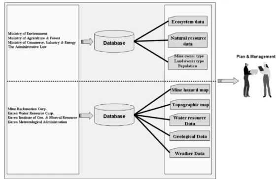
The Mine Reclamation Corps. (MRC) have issued guidance to regional redevelopmemt project to AML including ecological enhancement. MRC's document Guidance on prevention and reclamation of abandoned mine at AML (http://www.mireco.or.kr/jsp/bbs_template/
front/data07) describes how corrective actions can be completed, with contaminants remaining, using controls tailored to protection. Unfortunately, there are not in detail how to reuse or how to plan and manage AML for ecological purposes. The regulation and guidance of Ministry of Commerce, Industry and Energy (MCIE) has mainly documented about coal industry support, mine reclamation and clean-up and regional development. After all, MRC has been building up a mine GIS network designed to provide for the comprehensive management of such tasks as the prevention of safety-related accidents and environ- mental pollution in the mine area (http://www.
mireco.or.kr/eng/html/MR_D310_G100.jsp). However, there
are insufficient GIS data for ecological AML plan
and management. For these, building-up GIS DB
should be needed more than now. Especially, environ-
mental data, ecology data, ecosystem data, adminis-
tration information and information of local community
and industry should be builded up through Ministry
of Commerce, Industry, Energy (MCIE), Ministry of
Environment (ME) and Ministry of Agriculture and
Forestry (MAF) guidance, Then, decision makers will
make a strategic plan for redeveloping AML and GIS
information should be needed. The concept diagram
are described in Fig. 2. In GIS concept diagram, for ecological AML reuse and management, a GIS consists of spatially explicit information and two databases that combines them together to create a Web-based spatial analysis. Several information were already ended and is been collecting such as topographic map, water resource data and landuse data. This information can be displayed on a computer screen.
However, the most important thing is that metadata and information should be included for spatial analysis and management. For example, when point source pollutant map such as abandoned mine location with no information is shown on the computer, it is useless. Then, much of the information we collected and monitored about AMLs contains a relating that information at the point as a objective site. This GIS systems can help decision makers and developers make the most appropriate decision about ecological AMLs reuse. Specially, ecological information and ecosystem information should be necessarily.
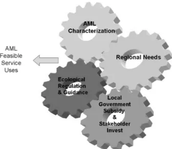
4. Estimation of ecological AMLs reuse
Every abandoned mine possesses a unique value to society that is dependent on its properties and its
relationship to the surrounding region (AML). The ability of an abandoned mine to produce jobs, housing, environmental habitat, mineral sources, agricultural goods, and other several values is the service capacity (Chao, 1983; Clark, 1911; Crew and Kleindorfer, 1971, 1976, 1986). The service capacity of an abandoned mine is dependent on its regional setting. For example, the Gangwon Land within Gangwon province has a very different service capacity than other all area in Gangwon province.
Actually, Gangwon Land is located on Jengseongun.
There were several big coal mines such as Sabuk coal mine. Moreover contamination reduced the service capacity and rather threaten the capacity of a site before mines are closed. After all, local economic situation was depressed. Now, the active of Gangwon Land contributes to improve regional economy and maximization of benefit although Gangwon land is not ecological aspect. The outset of reuse process is critically important as redistribution of benefits to invest AMLs. Bringing together interested stakeholders to pursue making benefits opportunities through AMLs reuse offers benefits to everyone involved. Then, estimation of ecological AML's reuse is based on the ethical code of active of regional economy, manage-
Fig. 2.
GIS Concept Diagram for Planning and Management.
6
이주영·한무영·양중석·최재영ment considers the interests of the stakeholders as an important factor, fair, transparent and honest manage- ment, observes the law and fulfills its social responsibility as proper business activities. Estimation of ecological AML's reuse can be expressed as venn diagram (Fig. 3).
5. Decision making
To accomplish strategic decision making, the concept of decision making process has been suggested through Fig. 4. The decision makers should have a future view and define a clear vision of the desired end use of AMLs. Here, GIS technique should play a vital role at the process of decision making for AMLs reuse. In general, decision making process should investigate the stage of exploration and analysis of effects of local communities and ecological/environmental resource. Specially, GIS technique may make explicit in recognition of ecological/
environmental impacts by AMLs reuse. Many thematic maps must provide a comprehensive information with picture of AMLs.
This paper suggests in concept model that decision- making process can be structured into several major steps as Fig. 4; clean-up, cost analysis, reviewing guidance, design, and action.
During the information in clean-up step is gathered to understand the situation for which a strategic decision is required. Cost analysis and review guidance
Fig. 3.
Venn diagram of the general elements used to estimate a AML's feasible service uses.
Fig. 4.