Spatial Patterns and Temporal Variability of the Haines Index related to the Wildland Fire Growth Potential over
the Korean Peninsula
Gwangyong Choi*, Junsu Kim**, and Myoung-Soo Won***
한반도 산불 확장 잠재도와 관련된 Haines Index의 시·공간적 특징
최광용*·김준수**·원명수***
Abstract:Windy meteorological conditions and dried fire fuels due to higher atmospheric instability and dryness in the lower troposphere can exacerbate fire controls and result in more losses of forest resources and residential properties due to enhanced large wildland fires. Long-term (1979-2005) climatology of the Haines Index reconstructed in this study reveals that spatial patterns and intra-annual variability of the atmospheric instability and dryness in the lower troposphere affect the frequency of wildland fire incidences over the Korean Peninsula. Exponential regression models verify that daily high Haines Index and its monthly frequency has statistically significant correlations with the frequency of the wildland fire occurrences during the fire season (December-April) in South Korea. According to the climatic maps of the Haines Index created by the Geographic Information System (GIS) using the Digital Elevation Model (DEM), the lowlands below 500m from the mean sea level in the northwestern regions of the Korean Peninsula demonstrates the high frequency of the Haines Index equal to or greater than five in April and May. The annual frequency of the high Haines Index represents an increasing trend across the Korean Peninsula since the mid-1990s, particularly in Gyeongsangbuk-do and along the eastern coastal areas. The composite of synoptic weather maps at 500hPa for extreme events, in which the high Haines Index lasted for several days consecutively, illustrates that the cold low pressure system developed around the Sea of Okhotsk in the extreme event period enhances the pressure gradient and westerly wind speed over the Korean Peninsula. These results demonstrate the need for further consideration of the spatial-temporal characteristics of vertical atmospheric components, such as atmospheric instability and dryness, in the current Korean fire prediction system.
Key Words : Haines Index, atmospheric instability, atmospheric dryness, frequency of the wildland fires, Geographic Information System (GIS), Digital Elevation Model (DEM)
요약: 대류권 하부의 높은 대기 불안정도와 건조도에 의해 바람이 강한 조건하에 화재 연료도 건조해지면 산불 통제가 어렵고 대형 산불에 의한 더 많은 산림자원과 재산의 손실을 초래할 수 있다. 본 연구에서 제시된 장기간(1979-2005)의 Haines Index는 한반도 상의 대기 불안정도와 건조도의 시공간적 패턴이 우리나라 산불 발생빈도에 중요한 영향을 미치고 있음을 잘 보여주고 있다. 산불 발생빈도와 Haines Index 사이의 지수회귀모델은 주요 산불 발생기간동안(12월-4월)의 Haines Index 일평균 값 혹은 월별 발생빈
* Ph.D. Candidate, Department of Geography, Rutgers The State University of New Jersey, [email protected]
** Ph.D. Candidate, Department of Meteorology, University of Utah, [email protected]
*** Research Scientist, Forest Fire Division, Korea Forest Research Institute, Republic of Korea, [email protected]
1. Introduction
In recent decades, the large-scale wildland fires that occurred across the Korean Peninsula resulted in catastrophic losses of forest resources and human properties. For instance, a large wildland fire in Goseong, Gangwon-do on April 23, 1996 and another repeated large wildland fire along the eastern coastal region on April 7-12, 2000 burned out approximately 3,760 ha and 23,450 ha of the forested areas, respectively.
Recently the incidences of large wildland fires are not limited to the eastern coastal areas, but also tend to occur even in the western regions of the Korean Peninsula. A large wildland fire in Cheongyang, Chungcheongnam-do on April 14, 2002, which burned out 2,216 ha of the forested areas, exemplifies the spatial diversity of large wildland fires in Korea. Most of wildland fire incidences in Korea are caused by human activities in spring, such as mountain climbing (47%), burning agricultural lands (19%), and family plot visiting and military firing training (34%) (http://www.foa.go.kr/), in contrast to the frequent wildland fires caused by lightning in North America (Krider et al., 1980; Rorig and Ferguson, 1999 and 2002). With the rapid economic development in Korea, the increase of
leisure activities in forested areas, such as mountain climbing, is expected to enhance the possibility of human-induced wildland fires in the future.
Under these circumstances, the Korean Forest Research Institute (KFRI; Lee and Won, 2004) developed the Korean Forest Fire Danger Rating System (KFFDRS) in the year 2003 to predict the wildland fire potential by referring to the Canadian Wildland Fire Information System (Van Wagner, 1987; Stocks et al., 1989; http://cwfis.- cfs.Nrcan. gc.ca/en/index_e.php) and the United States’ Wildland Fire Assessment System (Deeming et al., 1977; Burgan et al., 1997;
http://www.wfas.us /index.php). The KFFDRS produces the Fire Danger Rating Index maps by aggregating surface atmospheric information, forest information, and topographical information using the Geographic Information System (GIS).
The Fire Danger Rating Index maps derived from the KFFDRS are currently provided to the public by the KFRI (http://forestfire.kfri.go.kr/) and the Korea Meteorological Administration (KMA;
http://industry.kma.go.kr/APP/sub_APP 11.htm).
The KFFDRS is a good example of the useful hazard warning systems, which can help prevent or reduce the incidences and dispersals of the large wildland fires by offering more integrated 도가 우리나라 산불 발생빈도와 통계적으로 유의미하게 상관되어 있음을 보여준다. 지리정보시스템(GIS)에서 수치표고모델(DEM) 을 고려하여 작성한 Haines Index 기후도에 따르면, 5 이상의 높은 Haines Index는 주로 해발고도 500m 이하의 한반도 북서 저지 대를 중심으로 4-5월에 자주 발생하고 있다. 이러한 Haines Index의 발생빈도는 1990년대 중반 이후 한반도 전체적으로 증가하는 추세를 보이고, 특히 경상북도와 동해안 지역을 따라 산불기간 동안 가장 뚜렷하게 증가하는 패턴을 보였다. 연구기간 동안 높은 Haines Index가 2-3일 연속적으로 발생한 극사상(extreme events)이 나타나는 시기의 500hPa 종관 평균도에 따르면, 오호츠크해 에 발달한 한랭저기압이 한반도 중층대기의 기압경도력을 높여 동서의 강한 바람장을 형성하는데 도움을 주고 있음을 알 수 있다.
이러한 결과들은 현재 우리나라 산불 예보 시스템에 대기 불안정도나 건조도와 같은 대기의 수직적 요소들의 시·공간적 특성도 고 려되어야 하는 필요성을 잘 보여준다.
주요어 : Haines Index, 대기 불안정도, 대기 건조도, 산불 발생빈도, 지리정보시스템(GIS), 수치표고모델(DEM)
information including meteorological components, fire fuel components, and topographical compo- nents.
However, the indicative weakness of the KFFDRS includes the quality of input data in that the meteorological data used in the prediction system, such as air temperature, precipitation, humidity, and wind speed, are observed not in the forested areas but in residential areas. Thus, these data cannot reflect the actual meteorolo- gical conditions around the highly elevated and remotely forested areas where most of the large wildland fires occur. Moreover, these meteorol- ogical data observed at the regular weather stations do not include the information about atmos- pheric vertical structures, such as atmospheric instability and dryness, which are critical to the vertical fire growth over the steep and complex mountains areas of the Korean Peninsula. Atmos- pheric dryness and speedy wind, which are accelerated by atmospheric instability in the boundary layer, increase the difficulty in controlling and extinguishing the wildland fires at the early stage. The gusty wind attributable to the atmospheric instability tends to contribute to both increasing the dryness of forest fire fuels and spreading the fast and uncontrolled wildland fire on the highly sloped mountains. In particular, the fact that 70% of the Korean Peninsula consists of complex topography and forests needs a consideration of the atmospheric instability and dryness in the wildland fire management system, which intends to prevent the dispersal of the large wildland fires. In reality, atmospheric dyna- mical components, such as the seasonal progression of atmospheric instability and dryness, are critically affecting factors in the increase of the wildland fire growth potential, while both forest and topography are the given static circumstances.
To supplement the KFFDRS, therefore, this study examines the spatial and temporal patterns of the Haines Index (Haines, 1988) and the wildland fire records over the Korean Peninsula.
In addition to establishing a long-term (1979-2005) climatology of the Haines Index and wildland fires, this study intends to develop a fire prediction calendar and statistical models showing the empirical relationships between large wildland fire outbreaks and atmospheric instability and dryness in Korea.
2. Data and Methods
The Haines Index, or the Lower Atmosphere Stability Index, effectively quantifies the integrated contribution of atmospheric instability and dryness to the wildland fire growth potential by considering the vertical structures of both air temperatures and dew point temperature in the lower troposphere (Haines, 1988). The usefulness of the Haines Index has been fully validated in the United States regarding the prediction of the wildland fire growth potential (Haines, 1988;
Werth and Ochoa, 1993; Werth and Werth, 1998;
In and Zhong, 2005). Currently, daily Haines Index maps are popularly utilized (http://www.
fs.fed.us/land/wfas/haines.gif).
In detail, the equation for the Haines Index consists of two sub-indices: one for quantifying atmospheric instability, and the other for quantifying the dryness of the air, varying according to the altitude of the surface below (Equation 1). The first instability part in the equation calculates the difference of air temperatures between two geopotential heights and converts the difference to a unit-less value
Haines Index=Re-scaled Instability (Tp1-Tp2) +Re-scaled Dryness (Tp3-Tdp3)
……… (Equation1) Tpi=temperature at the pressure level of pi Tdpi=dew point temperature at the pressure level of pi
(1, 2, or 3). The geopotential heights involved in calculating the difference of air temperatures vary according to the elevation of the forested surface below as summarized in Table 1. The reason why the levels used in the equation vary according to the surface elevation is that the involved atmospheric layers should be high enough to eliminate the local or diurnal variability of surface temperature, such as the localized and temporary occurrences of tempera- ture inversion phenomenon (Haines, 1988). In particular, highly varying elevation across the Korean Peninsula requires an appropriate selection of atmospheric layers according to the surface elevation at each location from three combinations as classified in Table 1. For
example, the difference of temperatures between 850hPa and 700hPa is calculated when the elevation of surface is between 500m and 1,500m, while the difference between 950hPa and 850hPa is calculated when the elevation of surface is below 500m. Then, for instance, when the difference of temperatures above 700m of the surface from the mean sea level is 10℃, the difference of temperature between two geopotential heights is re-scaled to the value 2 as summarized in Table 1. The higher values imply the more unstable atmospheric structure vertically in the lower troposphere, which increases the potential growth of wildland fires.
Similarly, the second atmospheric dryness part in the equation calculates the difference between air temperature and dew point temperature at given two layers and then the difference is converted to a scale-less value (1, 2, or 3), similar to the conversion method for instability. The higher values in the second part of the equation indicate the drier condition, which is favorable for the spread of the wildland fires. Then, these
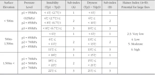
Table 1. Variables and scales for calculating the Haines Index according to different surface elevations (Haines, 1988).
Surface Pressure Instability Sub-index Dryness Sub-index Haines Index (A+B):
Elevation Level (Tp1- Tp2) (A) (Tp3- Tdp3) (B) Potential for large fires p1 = 950hPa < 4℃ (2.7℃) 1 < 6℃ 1
< 500m (925hPa) 4℃ (2.7℃)≤
2 6℃≤
p2 = 850hPa < 8℃ (6.7℃) < 10℃ 2
p3 = 850hPa < 8℃ (6.7℃)≤ 3 10℃≤ 3
500m- p1 = 850hPa
< 6℃ 1 < 6℃ 1 2-3: Very low
1,500m p2 = 700hPa 6℃≤
2 13℃≤
2 4: Low
p3 = 850hPa < 11℃ < 13℃ 5: Moderate
11℃≤ 3 13℃≤ 3 6: high
p1 = 700hPa
< 18℃ 1 < 15℃ 1
1,500m < p2 = 500hPa 18℃≤
2 15℃≤
2
p3 = 700hPa < 22℃ < 21℃
22℃≤ 3 21℃≤ 3
two re-scaled values are added as one Haines Index, which is ranging from 2 to 6. The Haines Index equal to or greater than 5 is regarded as showing critical atmospheric conditions to enhancing the possibility of wildland fire growth, because the probability of extreme fire behavior, including torching, crowning and spotting is significantly increased, when the value is 5 or 6 (Haines, 1988). The Haines Index equal to five indicates moderate potential for large wildland fire growth, while the Haines Index equal to six shows high potential for large wildland fire growth as summarized in Table 1.
In this study, daily mean temperature and relative humidity data at different pressure levels produced by the NCEP/NCAR (National Centers for Environmental Prediction/ National Center for Atmospheric Research) reanalysis model (Kalnay et al., 1996) are employed to calculate daily Haines Indices for the period 1979-2005. The equation 5 to gain the dew point temperature, which is needed to calculate the dryness in the Haines Index equation, is derived from relative humidity using Equations 2-4 based on the empirical relations between temperature, relative humidity, and dew point temperature (http://ingrid.ldeo.columbia.edu/dochelp/QA/Bas ic/dewpoint.html). The NCEP/NCAR reanalysis model offers the data for 925hPa instead of 950hPa needed in the original Haines Index.
Thus, considering the environmental lapse rate (0.6℃/100m) and the average difference (221.6m) of elevation between 925hPa (540.1m) and 850hPa (761.7m), the thresholds in the parenthesis in Table 1 are employed for the instability calculation for the surface below 500m of altitude in this study.
RH = E /Es×100 ……… (Equation 2) E =Eso×exp [Lv/Rv×(1/To-1/Td)]
……… (Equation 3) Es =Eso×exp [Lv/Rv×(1 / To-1/T)]
……… (Equation 4) Td(C) = 1/[1/T-Rv/Lv×1n(RH /100)]- 273.15
……… (Equation 5)
Es: Saturation vapor pressure E : Actual vapor pressure of the air RH : Relative humidity (%)
Eso: Reference saturation vapor pressure (6.11hPa)
Lv: Latent heat of vaporization of water (2.5×10⁶J/kg)
Rv: Gas constant of water vapor (461.5 J·K/kg) To: Reference temperature (273.15 K)
T : Temperature (K)
Td: Dew point temperature (K) Td(C) : Dew point temperature (℃)
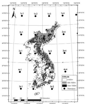
The spatial domain of the NCEP/NCAR reanalysis data used in this study is 122.5-132.5°E and 32.5-45°N, which is made up by 2.5°×2.5°
of grid cells (Figure 1). Total 20 grid cells, which cover the entire Korean Peninsula and the small portion of surrounding seas, used for creating interpolated maps. Total 8 grid cells over the Korean Peninsula (125.0-130.0°E and 32.5- 42.5°N) are utilized to demonstrate inter- or intra-annual variability of the Haines Index. The resolution of elevation data derived from the Digital Elevation Model, which shows the topography of the Korean Peninsula, is 102m×
102m. The Haines Index is calculated differently according to the elevation of the surface: below 500m, between 500m and 1,500m, and above 1,500m as shown in Table 1. Thus, using the Spatial Analyst and the Geostatistical Analyst
extensions of ArcGIS 9.1, an appropriate Haines Index out of three indices is selected and assigned to each smaller elevation grid cell according to the elevation. Then, using the GIS as described above, the long-term (1979-2005) average maps and inter-annual variability of daily, monthly, and annual Haines Indices are drawn for the Korean Peninsula. As presented in the results, the temporal and spatial patterns of inter-or intra-annual variability of the Haines Index equal to five are not necessarily consistent with those of the Haines Index equal to six.
Therefore, the Haines Index equal to five and six, which indicates moderate and high potential for large wildland fire growth respectively, are analyzed separately. In addition, the reason why only the post-1979 reanalysis data are used in this study is that the addition of satellite data to reanalysis models in the year 1979 caused an inconsistency in the quality of the NCEP/NCAR reanalysis data (Kalnay et al., 1996).
Then, both daily fire record available in South Korea arranged by the Korean Forest Research Institute for the period 1991-2005, and the reconstructed climatology of daily Haines Index for the Korean Peninsula are used to develop empirical regression models showing the relationships between vertical atmospheric structure and the frequency of wildland fire incidences in South Korea. In this study, simple linear regression and exponential regression models, in which the daily average value or monthly total frequency of high Haines Index is the independent variable and the frequency of wildland fires is the dependant variable, are tried.
Finally, the extreme events of the high Haines index are selected, when the daily Haines Index for the areas below 1,500m is equal to or greater than five across most of the Korean Peninsula
(125.0-130.0°E and 32.5-42.5°N). Then, only more than consecutive 2 day high Haines Index events are selected for the further synoptic analysis in this study. To understand the common synoptic condition for the selected 20 extreme events extracted from the long-term data, the composite and departure maps of daily geopotential heights, temperature, and wind speed at 925hPa, 850hPa, 700hPa, and 500hPa for these extreme daily events in April when the wildland fire and Haines Index has high values, are drawn using the IDL 6.2 (Interactive Data Language).
Figure 1. The topography of the Korean Peninsula superimposed by the altitude information extracted from the Digital Elevation Model in the GIS domain and by grid cells for the NCEP/NCAR reanalysis data.
3. Results and Discussion
1) Spatial and temporal normal of high Haines Index over the Korean Peninsula
Annual frequency of the Haines Index equal to five, which indicates a moderate condition of wildland fire growth potential, shows a west-east contrast over the Korean Peninsula (Figure 2).
The high annual frequency (greater than 70 days) is identified along the northwestern coastal regions from Pyeonganbuk-do to Chungcheong- buk-do, while the low annual frequency (less than 40 days) is found along the Nangrim, and Taebaek Mountain ridges where the altitude is above 500m from the mean sea level. The Yeongnam basin and the Hanla Mountain region show high annual frequency of the Haines Index
equal to five. In contrast, the annual frequency of the moderate Haines Index is relatively low in the northeastern mountainous regions of the Korean Peninsula, such as Hamgyeong-do in North Korea. This low frequency pattern in the northern regions is attributable to the fact that the northwesterly wind blown from the Siberian high pressure during the early or the late winter monsoon period can be interrupted by high topography in those regions.
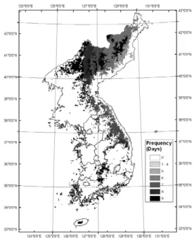
The highest Haines index equal to six, showing the highest wildland fire growth potential is rarely identified over the low lands below 500m of altitude compared with the moderate Haines Index maps (Figure 3). The annual frequency of the highest Haines Index is less than 1 day per year over the lowlands of the Korean Peninsula. Over the highlands more than 500m of altitude, the annual frequency of the
Figure 2. Long-term (1979-2005) average of annual frequency of the Haines Index equal to five (moderate potential for large wildland fire growth)
Figure 3. Long-term (1979-2005) average of annual frequency of the Haines Index equal to six (high potential for large wildland fire growth)
highest Haines Index equal to six increases in the range of 1-10 days. Both the Tabeak and the Sobaek Mountain ridges in South Korea, and the northwestern flank of the Nangrim Mountain ridge between 500-1,500m of altitude and the Hamgyeong Mountain ridge above 1,500m of altitude in North Korea show relatively high annual frequencies of the highest Haines Index equal to six. However, there is a similarity that the western flank of north-south backbone- shaped ridges over the Korean Peninsula above 500m of altitude shows higher frequency compared with the eastern flank of the mountain ridges.
The Haines Index equal to five shows diverse
intra-annual variability in the monthly average frequency according to latitudes, longitudes and altitudes over the Korean Peninsula, and the times of a year (Table 2). The general pattern in intra-annual progression of the monthly average moderate Haines Index is a bimodal distribution across the Korean Peninsula. The first highest peak appears in mid- or late spring, and the second less high peak is repeated in the mid-fall period. In contrast, mid-summer and winter show the lowest frequency of the moderate Haines Index during the year. This pattern shows slight modifications according to altitudes and latitudes. For instance, in North Korea, the
Table 2. Long-term (1979-2005) monthly frequency of the Haines Index equal to five (moderate potential for large wildland fire growth) in the Korean Peninsula. Grid is the number indicating the locations of cells as shown in Figure 1.
Altitude Grid Jan Feb Mar Apr May Jun Jul Aug Sep Oct Nov Dec
2x2 0 2 6 9 12 6 1 3 6 8 1 0
2x3 1 1 4 6 10 4 1 1 2 5 2 1
3x2 2 5 9 11 12 6 1 2 6 9 3 2
Below 500m 3x3 4 5 7 9 9 4 0 1 3 6 4 4
4x2 1 4 10 12 12 7 2 3 8 10 4 2
4x3 6 6 9 10 10 5 1 1 6 8 5 5
5x2 1 2 6 10 10 6 2 2 7 7 3 2
5x3 5 5 7 8 8 4 1 1 5 7 5 5
Altitude Grid Jan Feb Mar Apr May Jun Jul Aug Sep Oct Nov Dec
2x2 0 0 4 9 10 8 3 4 6 5 1 0
2x3 1 1 2 6 9 5 2 2 3 3 1 0
3x2 1 2 6 9 9 6 2 2 5 5 2 1
500m-1,500m 3x3 1 2 5 8 9 4 1 0 3 3 2 2
4x2 3 4 8 11 9 5 1 1 5 8 5 4
4x3 4 5 7 10 8 4 1 1 3 7 5 4
5x2 4 5 9 12 10 5 1 1 5 11 8 6
Altitude Grid Jan Feb Mar Apr May Jun Jul Aug Sep Oct Nov Dec
Above 1,500m 2x2 0 0 0 0 1 0 0 0 0 0 0 0
2x3 0 0 0 0 1 0 0 0 0 0 0 0
frequency of the moderate Haines Index is highest in May, while the frequency of the moderate Haines Index in South Korea is greatest in April. The highland on the Hanla Mountain, of which the altitude is above 500m, also shows higher frequency of the moderate Haines Index in April. The high frequency of the moderate Haines Index over the very highlands, of which the altitude is more than 1,500m, is detected only in the northern mountainous areas of North Korea in May.
The bimodal patterns in inter-annual variability
of the moderate Haines Index appear more clearly in the daily time series of the Haines Index for both below 500m and between 500- 1,500m of altitude (Figure 4). These daily possibility time series represent the ratio of the frequency of the moderate Haines Index on the same date during the study periods to the total study years (1979-2005) for the entire Korean Peninsula (125-130°E and 32.5-42.5°N), which is equivalent to the grid cells summarized in Table 2 for each range of the elevation. According to these time series data, the possibility of the occurrence of the moderate Haines Index across the Korean Peninsula is maximized up to 40% at the end of April both below 500m (Figure 4(a)) and between 500-1,500m (Figure 4(b)) of altitude. Then, the possibility drops suddenly in July and maintains the minimum stage until the end of August. With the beginning of September, the possibility begins to increase, but the second peak in mid-fall is lower than the maximum peak at the end of April. During the cold period (December-February), the possibility is as low as that during the warm period (June-August).
These results verify that in mid-spring, the atmosphere in the low troposphere is the most unstable and driest over the Korean Peninsula, which provides the favorable conditions to the spread of large wildland fires.
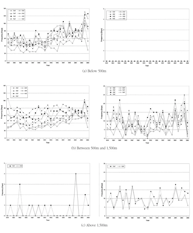
2) Inter-annul variability and changes in spatial patterns of high Haines Index.
Annual frequency of the Haines Index equal to five shows an increasing trend after the mid- 1990s below 500m of altitude across the Korean Peninsula and a slight increase is detected also in the highlands between 500-1,500m of altitude along the Taebaek Mountain and the Soebaek (a) Below 500m
(b) Between 500m and 1,500m
Figure 4. Possibility of daily occurrences of the Haines Index equal to five (moderate potential for large wildland fire growth) below 500m (a) and between 500-1,500m (b) of altitude across the Korean Peninsula.
(a) Below 500m
Haines Index=5 (moderate) Haines Index=6 (high)
(b) Between 500m and 1,500m
(c) Above 1,500m
Figure 5. Inter-annual variability of the Haines Index equal to five (moderate: left column) and six (high; right column) according to the elevations: below 500m (a), between 500m and 1,500m (b), and above 1,500m (c).
Refer to Figure 1 for the location of each grid cell number in each legend of graphs.
Mountain ridges (Figure 5). The annual average frequency of the moderate Haines index equivalent to five for the pre-1993 period is approximately 40 days, but this average has doubled in the post-1993 period with an average frequency of approximately 80 days. In the case of the highlands between 500-1,500m of altitude in the eastern highland regions of South Korea, that is, along the Taebaek and Soebaek Mountain ridges, the annual frequency is changed from approximately 30 days in the pre-1995 period to approximately 50 days in the post-1995 period.
In contrast, there is no noticeable inter-annual increasing or decreasing trend in the frequency of the Haines Index equal to six or in case of other elevations.
In addition, there are several comparable aspects between the time series of the Haines index equal to five and to six. The cases of the highest Haines index equal to six do not appear in lowlands below 500m of altitude for the study period, while the moderate Haines Index equal to five is common in the lowland areas below 500m across the Korean Peninsula. Comparatively, the annual frequency of the highest Haines Index equal to six in the very highlands above 1,500m of altitude exceeds that of the moderate Haines Index equal to five. The infrequent highest Haines Index above the low-elevated areas is attributable to rare occurrences of extreme atmosphere instability.
Based on inter-annual changes shown in the time series of Figure 5, the annual average frequency of the Haines Index equal to five for the post-1993 period (1979-1992) is compared with that for the pre-1993 period (1993-2005) across the Korean Peninsula (Figure 6). Overall, the frequency of the moderate Haines Index equal to five increased across the Korean
Peninsula by 5-35 days in the post-1993 period except for the highlands above 500m of altitude in the southern regions. The most significant increase of the annual frequency is identified in Chungcheongbuk-do, Gyeongsangbuk-do, Gangwon-do, and the eastern costal areas in South Korea. In particular, it is in the Yeongnam basin areas in Gyeongsangbuk-do below 500m of altitude that the increase of the annual frequency more than 30 days appears. In contrast, the increase of the annual frequency in the northern highland above 500m in North Korea is relatively small. For instance, the difference in the annual frequency between the pre- and post-1993 periods is less than 5 days across the very highlands above 1,500m in Hamgyeong-do. Similarly, the difference between the pre- and post-1993 periods is not clear or Figure 6. Changes in the annual frequency of the Haines Index equal to five (moderate potential for large wildland fire growth) between the pre-1993 and post-1993 periods.
slightly decreased over the highlands in the southern regions of the Korean Peninsula along the Seobaek Mountain ridge, including the Hanla Mountain compared with the lowlands below 500m of altitude.
These changes in the annual frequency of the moderate Haines Index equal to five are more apparent in spring and fall as shown in Table 3.
Locally, both the eastern coastal areas below 500m of altitude and the highlands of the Taebeak Mountain ridge between 500-1,500m of altitude in the grid cell of 3x3 (127.5-130°E and 37.5-40°N) show the most significant increase in March during a year in the Korean Peninsula.
Over the highlands above 500m of altitude in the southern regions of the Korean Peninsula, the frequency shows decreased patterns in January, April, September, and October. Increases in the frequency of the Haines Index equal to five the above 1,500m of altitude in Hamgyeong-do, which is the northern part of the Korean Peninsula, occurred in mid-spring and mid-fall.
In contrast, there is no significant increase or decreasing pattern above 1,500m of altitude in Hamgyeong-do in neither mid-winter nor mid- summer.
Table 3. Changes in the monthly frequency of the Haines Index equal to five (moderate potential for large wildland fire growth) between the pre-1993 and post-1993 periods in the Korean Peninsula.
Altitude Grid Jan Feb Mar Apr May Jun Jul Aug Sep Oct Nov Dec
2x2 0 1 2 4 1 2 0 2 3 0 1 0
2x3 0 1 2 4 2 3 0 0 2 1 2 0
3x2 1 2 4 3 3 2 0 2 5 2 1 1
Below 500m 3x3 1 3 6 3 4 2 0 0 3 3 2 3
4x2 1 2 4 3 3 3 0 1 4 3 3 1
4x3 2 3 5 4 3 3 0 1 2 4 3 2
5x2 2 1 3 5 4 3 0 0 1 3 2 0
5x3 2 2 4 6 3 2 0 0 0 2 1 0
Altitude Grid Jan Feb Mar Apr May Jun Jul Aug Sep Oct Nov Dec
2x2 0 0 2 0 2 0 1 3 3 0 0 0
2x3 0 1 1 1 2 1 0 1 3 1 0 0
3x2 0 1 2 0 1 0 1 1 2 1 0 0
500m-1,500m 3x3 0 1 3 1 0 0 0 0 3 1 1 2
4x2 -2 2 0 -1 1 1 0 0 -1 0 1 0
4x3 -1 2 2 0 0 0 0 0 -1 0 0 0
5x2 -1 1 0 -2 0 1 0 0 -1 -2 0 0
Altitude Grid Jan Feb Mar Apr May Jun Jul Aug Sep Oct Nov Dec
Above 1,500m 2x2 0 0 0 1 1 1 0 0 1 0 0 0
2x3 0 0 0 1 1 1 0 0 1 0 0 0
3) Statistics of long-term (1991-2005) daily average of wildland fire occurrences and its relationship with the high Haines Index in South Korea
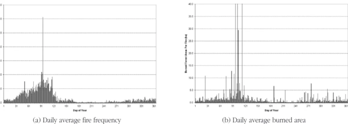
The wildland fire incidences in South Korea show a tilted modal distribution during a year (Figure 7(a)). The wildland fire incidences begin to increase in February and approach climax approximately at the beginning of April. The fire season in South Korea is from the late winter and mid-spring when the accumulated impact of the
dry northeastern Asia winter monsoon is large, while the fire season in the Untied States is from July to August when the frequency of lightning is maximized (Flannigan and Harrington, 1988;
Westerling et al., 2003). Then, the wildland fire incidences begin to decrease and approach to the lower extreme approximately in mid-May.
The noticeable daily maximum frequency of the wildland fire incidences is detected on April 5, which is ironically the previous national holiday for planting trees in South Korea.
(a) Daily average fire frequency
(a) Daily relationship
Figure 7. Intra-annual progression of the long-term (1991-2005) average of the daily fire frequency (a) and the daily burned area per fire case (b) in South Korea.
(b) Daily average burned area
(b) Monthly relationship
Figure 8. Exponential relationships between the average frequency of daily fire occurrences and daily average Haines Index (a) and between the average frequency of monthly fire occurrences and monthly average frequency of the Haines Index (b) equal to five below 500m of altitude across South Korea for the fire season (December to April) during the 1991-2005 period.
The daily example shows the characteristic that most of the wildland fire incidences in Korea are caused by human activities near mountains between late winter and mid-spring. The fact that most of the wildland fires (more than 65%) occurs below 500m of altitude which is a range accessible by people (Lee, 2005), also supports the logic of human-induced fires in South Korea.
The difference between intra-annual wildland fire frequency and intra-annual high Haines Index is that the distribution of the wildland fire is tilted toward the early times of a year with approximately one-month advance compared with the distribution of intra-annual frequency of the high Haines Index. This aspect may be related to the timing of the greening of trees in the Korean Peninsula. Most of the mountainous areas in South Korea are covered with the green trees at the beginning of May, which indicates the mid-spring based on the progression of daily temperature during a year (Choi et al., 2006).
However, the intra-annual distribution of the average of the burned areas per fire shows high values only in April. The intra-annual patterns of the fire-burned areas differ from the intra-annual distribution of the wildland fire daily frequency in that in February and March, the burned area per fire does not show any noticeable increase (Figure 7(b)). For example, two large wildland fires along the northeastern coastal areas in South Korea on April 7 and April 12 in the year 2000 resulted in peaks of the burned forest areas per fire of more than 240ha and 140ha respectively, which much exceed the domain of Figure 7(b).
This temporal pattern may be more related to the accumulated dryness and atmospheric instability because the intra-annual distribution of the burned area per fire is more similar to the intra- annual distribution of the high Haines Index
(Figure 4). However, because of the exaggerated magnitude of the average burned areas by only several large wildland fires, a direct comparison between the wildland fire burned areas and the daily Haines Index shows poor statistical significance in the regression model (not given).
In contrast, Figure 8 shows the significant relationships between the Haines Index or its frequency and the wildland fire frequency during the fire season (December-April) based on long- term (1991-2005) wildland fire records in South Korea. In Figure 8(a), the exponential regression curve based on the pairs for the daily Haines Index and the same date fire frequency clearly verifies that the atmospheric instability and dryness affect the frequency of fire incidences in South Korea. The exponential regression curve accounts for approximately 60 % of the relation- ship and allows a prediction that there would be ten times more of the fire incidence as daily Haines Index increase from 3.5 to 4.5 during the fire season (December-April). Similarly, the monthly frequency of the Haines Index equal to five is exponentially related to the monthly average frequency of the wildland fires during the fire season (December-April), according to the long-term (1979-2005) monthly datasets (Figure 8(b)). This means that the higher Haines Index frequency is indicative of the more wildland fires on the monthly basis too, because the rate of the increase is getting larger exponentially as the monthly frequency of the moderate Haines Index increases. The exponential regression curve for the monthly relationship also accounts for approximately 60%
of the variation of monthly fire occurrences and indicates that when the monthly frequency of the Haines Index equal to five is greater than 20 days per month like that in April, the total of monthly
fire incidences are more than 100. Overall, these results accentuate that the atmospheric vertical parameters, such as atmospheric instability and dryness in the lower troposphere, contribute significantly to the wildland fire incidences in South Korea.
4) Extreme Cases of High Haines Index and its synoptic characteristics.
The extreme records of the Haines Index equal to or greater than five across the Korean Peninsula (125-130°E and 32.5-42.5°N) illustrate a seasonal tendency more clearly as shown in Figure 9. Obviously, most of the extreme cases occur between mid-April and the end of May, except for several events in October during the study period. The annual frequency of the extreme cases, which is represented by the bar graph in Figure 9, shows an increasing trend during the study period. In particular, the increasing tendency is detected apparently in the mid-1990s. In the pre-1993 period, the annual frequency of daily extreme events is approximately
two, while in the post-1993 period the average frequency of extreme cases is more than five days per year. During the study period, the frequency of the extreme cases approached the maximum, 14 days in the year 2004. This pattern indicates that the Korean Peninsula is getting more exposed to the wildland fire-favorable conditions in mid-spring.
The extreme cases occurred in April during the study period, when the Haines Index across the Korean Peninsula is equal to or greater than five for several consecutive days, are summarized in Table 4. Figure 10 shows the composite and departure maps of the 500hPa geopotential height, temperature and wind vector for the northeast Asia (90-180°E and 0-80°N) for these extreme events. According to the composite synoptic maps, the low pressure is developed around the Sea of Okhotsk, while the high pressure system is developed in the western Pacific at low latitudes. The temperature anomaly around the Sea of Okhotsk is lower than that in the surrounding regions. This low pressure around the Sea of Okhotsk is more clearly illustrated in the departure maps as shown in Figure 10 (b). During the extreme events, a Table 4. Extreme records that the Haines Index equal to or greater than five lasted for more than consecutive two days in April across the entire Korean Peninsula during the study period(1979- 2005).
Year First Date Last Date Duration (Days)
1981 115 116 2
1991 111 112 2
1994 104 105 2
1997 101 103 3
2001 115 116 2
2003 95 96 2
Figure 9. Intra-annual and Inter-annual variability of extreme events of the high Haines Index equal to or greater than five occurred across the entire Korean Peninsula.
(a) Composite map
(b) Departure map
Figure 10. A composite map for the extreme cases of the Haines Index occurred in April for the study period (a) and its departure map from the long-term average (b) consisting of the geopotential height (solid lines with numbers for the height), air temperature (grey color scale), and wind vector (arrow) at 500hPa (see Table 4 for the detail).
strong negative core of the geopotential height at 500hPa is detected around the Sea of Okhotsk.
The geopotential height during the extreme events is lower by 160m compared with long- term average, and the temperature is also lower by 7°C from the long-term average around the Sea of Okhotsk. Over the Korean Peninsula, the negative temperature and anomaly bands at 500hPa cross, while the geopotential height at 850hPa shows a slight positive departure (not given). Thus, the cold air in the mid-troposphere and the warm air in the lower troposphere increase the atmospheric instability.
As a result, the westerly wind is enhanced along the Korean Peninsula and Japan as both the cold low pressure system and the high pressure increases the pressure gradient over the Korean Peninsula and Japan. The enhanced pressure gradient results in high wind speed (faster than 10 m/s) across the Korean Peninsula.
This result is consistent with the recent finding by Crimmins (2006) that the large geopotential height gradients appear as most of the extreme fire-weather patterns across the southwestern United States. Overall, the juxtaposition of the high-low pressure systems seems to determine the pressure gradient that enhances the westerly wind over the Korean Peninsula. However, there is no detectable baroclinic pattern over the Korean Peninsula during these extreme events.
4. Summary and Conclusion
It is concluded that the Haines Index effectively reflecting the atmospheric instability and dryness is significantly associated with the wildland fire incidences in South Korea. The results revealed in this study so far suggest that the consideration
of the vertical atmospheric structure should be made in order to enhance the quality of the current wildland fire warning system in South Korea. In particular, the fact that the Haines Index used in this study shows significant statistical relationships with the actual numbers of past wildland fire incidences in South Korea supports the necessity of inputting the 3- dimensional atmospheric components, such as Haines Index, in the current fire prediction system. The details of findings in this study, which may be helpful to the fire prediction system, can be summarized as follows:
First, daily values or monthly frequency of the high Haines Index, which quantifies the atmospheric instability and dryness, accounts for approximately 60% of the variation of the daily or monthly fire frequencies during the fire season (December-April) in South Korea.
Second, the intra-annual frequency distribution of the Haines Index shows a bimodal pattern, in which the high peak occurs in mid-spring and second weak peak repeats in mid-fall.
Comparatively, the peak in the intra-annual wildland fire occurrences is identified only in mid-spring.
Third, high Haines Index is identified more in the northwestern low regions below 500m of altitude along the West Sea in April when the wildland fires are most frequent during the year.
In contrast, in the highly elevated northern regions of the Korean Peninsula, such as Hamgyeong-do in North Korea, the annual frequency of the high Haines Index is relatively low compared with those for other regions.
Fourth, inter-annual occurrence of the high Haines Index shows an increasing tendency in the post-1993 period mainly in the lowlands below 500m of altitude. The most noticeable
increasing trend is found in the Yeongnam region and along the eastern coastal areas below 500m of altitude.
Fifth, according to the composite of synoptic weather maps at 500hPa for the extreme Haines Index events in April, the cold low pressure around the Sea of Okhotsk and the warm high pressure in the western Pacific at low latitudes enhance the pressure gradient across the Korean Peninsula during the extreme episodes.
These climatological characteristics of the Haines Index and wildland fires over the Korean Peninsula help to improve the current fire warning system. However, the inconsistency in the high Haines Index period and high fire frequency period indicates that the collaboration of the Haines Index with the intra-annual changes of the surface forest as the source of fire fuel is needed. For instance, even if the Haines Index is still high in May which means atmospheric shows high instability and dryness, the leafing and greening of trees proceed to gain more moisture in May. Therefore, wildland fires cannot disperse to the forest due to high moisture content in trees. Thus, in addition to the forest information used in the current Korean fire prediction models, such as types of trees and percentage of forested areas, the temporal data about the intra-annual physiology of trees should be included for the better prediction of the wildland fire spread potential. Another important component is humans’ accessibility to vulnerable areas at particular times of the year because most of the wildland fires in Korea are caused by human activities. Thus, time geography of human activities near forested areas should be considered in the future studies regarding the wildland fire incidences in Korea. Finally, the brief-done synoptic analysis in the last chapter
(Figure 10) needs further work to reveal the relationship between different levels of the atmosphere in the context of the large-scale climate patterns (Simard et al., 1985; Swetnam and Betancourt, 1990; Skinner et al., 1999 and 2002; Westerling et al., 2003; Crimmins, 2006;
Trigo et al., 2006) and current climate change related to greenhouse gas emission (Price and Rind, 1994; Reinhard et al., 2005). Moreover, local- scale fire research is needed to reveal the impact of topography and pre-conditions, such as Foehn and droughts (Reinhard , 2005) in the future.
Acknowledgement
Authors would like to convey many thanks to the Korea Forest Research Institute for the fire data offering and to the NCEP/NCAR CDC for the reanalysis data offering. We also appreciate a proof-reading done by Mr. David Gwynn and Ms. Alexis Buckley in Department of Geography at Rutgers University and enormous helpful comments from anonymous reviewers for improving this manuscript.
References
Burgan, R.E., Andrews, P.L., Bradshaw, L.S., Chase, C.H., Hartford R.A., and Latham, D.J., 1997, WFAS:
wildland fire assessment system, Fire Manage- ment Notes, 57(2), 14-17.
Choi, G., Kwon W.-T., and Robinson, D.A., 2006, Long- term spatial patterns and recent trends of seasonal onset and duration in South Korea, Journal of the Korean Geographical Society (in review).
Crimmins, M.A., 2006, Synoptic climatology of extreme fire-weather conditions across the southwest
United States, International Journal of Climatology, 26, 1001-1016.
Deeming, J.E., Burgan, R.E., and Cohen, J.D., 1977, The National Fire-Danger Rating System-1978.
Gen. Tech. Rep. INT-39. Ogden, UT: U.S. Depa- rtment of Agriculture, Forest Service, Intermountain Forest and Range Experiment Station.
Flannigan, M.D. and Harrington, J.B., 1988, A study of the relation of meteorological variables to monthly provincial area burned by wildland fire in Canada (1953-80), Journal of Applied Meteoro-logy, 27(4), 441-452.
Kalnay, E., Kanamitsu, M., Kistler, R., Collins, W., Deaven, D., Gandin, L., Iredell, M., Saha, S., White, G., Woollen, J., Zhu, Y., Leetmaa, A., Reynolds, B., Chelliah, M., Ebisuzaki, W., Higgins, W., Janowiak, J., Mo, K.C., Ropelewski, C., Wang, J., Roy, J., and Joseph, D., 1996, The NCEP/NCAR Reanalysis 40- year Project, Bulletin of the American Meteoro- logical Society, 77, 437-471.
Haines, D.A., 1988, A lower atmospheric severity index for wildland fire, National Weather Digest, 13(2), 23-27.
In, H.-J. and Zhong, S., 2005, Validation of the Haines Index predicted from real-time high-resolution MM5 forecasts using rawinsonde observations over the eastern half of the USA, International Journal of Wildland Fire, 14(3), 233-244.
Krider, E.P., Noggle, R.C., Pifer, A.E., and Vance, D.L., 1980, Lightning direction-finding systems for forest fire detection, Bulletin of the American Mete-orological Society, 61(9), 980-986.
Lee, S.Y., 2005, Fire mitigation near the forest, Magazine of the Korean Society of Hazard Mitigation, 5(2), 66-70 (in Korean).
Lee, S.Y. and Won, M.S., 2004, The Korean forest fire danger prediction system, Journal of National Institute for Disaster Prevention, 6(4), 18-24 (in Korean).
Price, C. and Rind, D. 1994, The impact of a 2×CO2
climate on lightning-caused fires, Journal of
Climate, 7(10), 1484-1494.
Reinhard, M., Rebetez, M., and Schlaepfer, R., 2005, Recent climate change: Rethinking drought in the context of forest fire research in Ticino, South of Switzerland, Theoretical and Applied Climatology, 82, 17-25.
Rorig, M.L. and Ferguson, S.A., 1999, Characteristics of lightning and wildland fire ignition in the Pacific Northwest, Journal of Applied Meteorology, 38(11), 1565-1575.
Rorig, M.L. and Ferguson, S.A., 2002, The 2000 fire season: lightning-caused fires, Journal of Applied Meteorology, 41(7), 786-791.
Simard, A.J., Haines, D.A., and Main, W.A., 1985, Relations between El Nino/Southern Oscillation anomalies and wildland fire activity in the United States, Agriculture and Forestry Meteorology, 36, 93-104.
Skinner, W.R., Stocks, B.J., Martell, D.L., Bonsal, B., and Shabbar, A., 1999, The association between circulation anomalies in the mid-troposphere and area burned by wildland fire in Canada, Theoretical and Applied Climatology, 63, 89-105.
Skinner, W.R., Flannigan, M.D., Stocks, B.J., Martell, D.J., Wotton, B.M., Todd, J.B., Mason, J.A., Logan, K.A., and Bosch, E.M., 2002, A 500 hPa synoptic wildland fire climatology for large Canadian forest fires, Theoretical and Applied Climatology, 71, 157-169.
Stocks, B.J., Lawson, B.D., Alexander, M.E., Van Wagner, C.E., McAlpine, R.S., Lynham, T.J., and Dube, D.E., 1989, The Canadian Forest Fire Danger Rating System: An overview, The Forestry Chronicle, 65(6), 450-457.
Swetnam, T.W., and Betancourt, J.L., 1990, Fire-Southern Oscillation relations in the southwestern United States, Science, 249, 1017-1020.
Trigo, R.M., Pereira, J.M.C., Pereira, M.G., Mota, B., Calado, T.J., Dacamara, C.C., and Santo, F.E., 2006, Atmospheric conditions associated with the exceptional fire season of 2003 in Portugal, International Journal of Climatology (in press).
Van Wagner, C.E., 1987, Development and structure of the Canadian Forest Fire Weather Index System, Canadian Forestry Service, Headquarters, Ottawa, Forestry Technical Report, 35.
Werth, P. and Ochoa, R., 1993, The evaluation of Idaho wildland fire growth using the Haines Index, Weather and Forecasting, 8(2), 223-234.
Werth, J. and Werth, P., 1998, Haines Index climatology for the western United States, Fire Management Note, 58(3), 8-17.
Westerling, A.L. , Gershunov, A., Brown, T.J. , Cayan, D.R., and Dettinger, M.D., 2003, Climate and wildla-nd fire in the western United States, Bulletin of the American Meteorological Society, 84(5), 595-604.
http://cwfis.cfs.nrcan.gc.ca/en/index_e.php http://forestfire.kfri.go.kr/
http://industry.kma.go.kr/APP/sub_APP11.htm
http://ingrid.ldeo.columbia.edu/dochelp/QA/Basic/dew point.html
http://www.foa.go.kr/
http://www.wfas.us/index.php
http://www.fs.fed.us/land/wfas/haines.gif
Correspondence: Gwangyong Choi, Department of Geography, Rutgers The State University of New Jersey, 54 Joyce Kilmer Ave., Piscataway, NJ, 08854, The United States. (e-mail: tribute@han- mail.net
교신:최광용, 미국 럿거스 뉴저지 주립대학 지리학과, (이메일: [email protected])
Received May 16, 2006 Accepted June 18, 2006