Harmful Algal Blooms in the South Sea of Korea using Satellite and In-situ Data during Summer Season 2004
Widhiyanuriyawan Denny1, Dae Hyun Kim2, Yong-Hyun Chung3, Hong-Joo Yoon1
1Department of Geoinformatics Engineering, Pukyong National University, Daeyeon 3-Dong, Nam-Gu, Busan 608-737, Korea. [email protected]
2GEMATEK Co, Ltd. Daeyeon 3-Dong, Nam-Gu, Busan , Korea. [email protected]
3Department of Ecological Engineering, Pukyong National University, Daeyeon 3-Dong, Nam-Gu, Busan 608-737, Korea
Abstract
Harmful algal blooms (HABs) have become temporally disaster that usually appears in the South Sea of Korea in summer season. Cochlodimium polykrikoides is dominant species that causative of HABs and causing impact on economic, aquaculture and human health in Society. Object of our present study finds the characteristics of the formation, distribution and advection of HABs by using satellite and in-situ data. The results show that the bloom originated in the South Sea of Korea caused massive transport of Chlorophyll-a from East China Sea that detected by satellite image in 29 July 2004. In-situ data recorded that the initiation of blooming in the South Sea of Korea is Yeosu in 5 August 2004 and Tongyeong, Wando recoded on 7 August 2004. The HABs developed southeastward when SST increased to 25~27ºC on the coastal area and more SST (≥27 ºC) in offshore. The high temperature in the Korea Strait indicates Tsushima Warm Current pass in this area and influence on the temperature in coastal areas. The long period of blooming is shown in the Wando, Yeosu and Tongyeong until early September. The high precipitation rate induces more sustainability of blooming for longer period. The mean value of winds speed (calm wind- 2~5 m/s) in summer 2004, was also favored the blooming.
1. Introduction
Harmful Algal Blooms (hereafter HABs) is one of the temporal disaster in the South Sea of Korea which dominated by Cochlodinium polykrikoides species (Lee et al., 2002; Shanmugam et al., 2008). The HABs have caused serious impact on fisheries resources, economic, ecology, human health. Considerable economic losses due to HABs were estimated at $95 million and $19 million USD in 1995 and 2003, respectively (NOWPAP, 2005), the mitigation of HABs impact essential to do.
Remote sensing has long been considered an obvious tool for studying the distribution of HABs organisms over larger spatial scales and longer time scales than what possible with ship-based sampling (Tang et al., 2003a & b, 2004a & b, 2006; Ahn et al., 2006).
The previous studies explained environmental conditions such as oceanic parameters were known to be water temperature, salinity, nutrients and metrological parameters were known to be air temperature, precipitation, winds and sunshine (Yamamoto et al., 1997; Yoon and Kim, 2003) influence on HABs (Lee and Lee, 2006; Lee, 2006). Object of our present study finds the characteristics the formation, distribution and advection of HABs by using satellite and in-situ data in summer season 2004.
2. Study area, data and methods 2.1 Study area
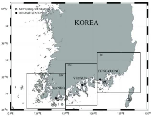
The study area was Wando, Yeosu and Tongyeong areas, which is located in the South Sea of Korea (Fig. 1).
Fig.1. Study area is Wando, Yeosu and Tongyeong which are located in the South Sea of Korea.
2.2 Data
The satellite data of Sea viewing Wide Field of viewing Sensor (SeaWiFS) level 1 A were obtained from Korean Ocean Research and Development Institute (KORDI). The ocean color 4-band algorithm (OC4) (O’Reilly et al., 1998) has been used in SeaWiFS Data Analysis System (SEADAS) version 5.2 to process available SeaWiFS derived Chl-a images for the South Sea of Korea during Summer 2004 when the HABs event occurred. For analysis HABs in the coastal area we use Red tide index Chlorophyll Algorithm (RCA) from Ahn and Shanmugam(2006). And the analysis of movement of HABs in the South Sea of Korea, we focused our attention in the offshore water using OC4 algorithm.
The Sea Surface Temperature (SST) images derived from the Advanced Very High Resolution Radiometer (AVHRR) data which have 1 x 1 km2 spatial resolutions were obtained from National Fisheries Research and Development Institute (NFRDI).
In-situ data encompasses oceanic parameters and meteorological parameters obtained from NFRDI and Korea Meteorology Administration (KMA), respectively.
3. Results and discussion 3.1 Satellite data
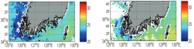
Satellite images OC4 and SST show that the massive intrusion chlorophyll-a from East China Sea which brought by Tsushima and Jeju Warm Current which depicted in Fig. 2. These intrusions brought some
nutrients which as trigger HABs in coastal area in the South Sea of Korea. The satellite data using RCA that has better perform than OC4 algorithm to detect HABs in the Korean coastal area shows HABs occurred in Yeosu and eastern part of Tongyeong in 29 July 2004 (Fig. 3) that occurrences not recorded as C. polykrikoides (HABs) which depicted in Fig. 7. According in-situ data from NFRDI these occurrences is harmless species blooming that caused by environment conditions as sunshine and temperature favored for blooming (data not showed in this paper). The irregular shape of the island affected on water circulation in coastal area. Due to limited studies, it was not studying circulation current in the coastal area.
Fig. 2. Satellite images OC4 (a) and SST (b) in 29 July 2004.
Fig. 3. Satellite images OC4 (a) and RCA (b) in 29 July 2004 from SeaWiFS.
Fig. 4. Satellite images OC4 (a) and SST (b) in 7 August 2004.
Fig. 5. Satellite images SST on (a) 5 and (b) 7 August 2004.
Fig. 6. Satellite images SST in 1 (a) and 2 (b) September 2004.
The in-situ data recorded that the initiation HABs occurrence in the South Sea of Korea on 5 August (Yeosu), on 7 August (Wando and Toengyeong) that shown in Fig. 7. Satellite image SST data on 5 August showed the temperature in the Yeosu coastal area higher than other coastal areas. The temperature around 25~27ºC triggered HABs in Yeosu on 5 August. The SeaWiFS ocean color on 5 August is not displayed due to clouds mask covered Korean region. Satellite SST on 7 August show distribution temperature in the coastal area around 25~27ºC and indicate HABs occurrence in Wando, Yeosu and Tongyeong. The high temperatures (t
≥ 26ºC) on the Korean Strait in Fig. 5 showed the Tsushima Current pass in this area. The temperatures of Tsushima Warm Current on 7 August (t ≥ 28ºC) show higher than on 5 August (t ≥ 26ºC). The higher temperature of Tsushima Warm Current impacted on water temperature of coastal area for distribution and advection HABs. According to Kim et al. (2004), water temperature has the greatest influence on the growth rate of C. polykrikoides, which is able to grow at 15~30°C (optimum temperature = 21~26°C and salinity = 20~36 psu). Fig.6 show that temperature in the South Sea of Korea on 1 and 2 September 2004 which indicate the temperature of Tsushima Warm Current decrease and the HABs occurrence in the coastal area decayed.
3.2 In-situ data
In-situ data for oceanic parameters which depicted in Fig.
7 show that HABs occurrence dominant on August.
Water temperature ranged 20~30ºC. The relationship between HABs occurrence and the meteorological parameters for Wando, Yeosu and Tongyeong are shown in Fig. 8, Fig. 9, and Fig.10, respectively. The satellite
data, the HABs occurrences are drawn blue and yellow shadow, respectively in the meteorological parameters.
Fig.7. Individual number and water temperature of oceanic parameters indicate HABs in the South Sea of Korea during summer 2004.
The HABs occurrence in Wando, Yeosu and Tongyeong were 4, 2 and 1 occurrence, respectively. In Wando, the periods of HABs were 14 days (7~20 August), 5 days (23~27 August), 1 day on 29 August and 2 September. The mean value of wind speed during summer season was 3.79 m/s (northwesterly) and accumulated precipitation 353.5 and 23.5 mm/day occurred on 18~19 August when HABs were occurring.
In Yeosu, the periods of HABs were 3 days (5~7 August), 24 days (during 9 August to 2 September). The mean value of wind speed during summer season was 4.52 m/s (southwesterly) and precipitation which accumulated 0.2~153.5 mm/day occurred on 14~24 August when HABs were occurring. In Tongyeong, period of HABs were 23 days (7~29 August). The mean value of wind speed during summer season was 2.53 m/s (northeasterly). The accumulated precipitation 0.5 ~ 85.5 mm/day also occurred on 15~24 August when HABs were occurring.
We analysis that same trend occurs in Wando, Yeosu and Tongyeong. The time duration of occurrence similar and the precipitation which occurs induce more sustainability of blooming for longer period. Yeosu area shows the longest period because anthropogenic activities in nearby cities such as Suncheon and Gwangyang can input nutrients into the Seomjim River estuary after a heavy rain event (Lee, 2006). The wind speed in Yeosu ranged 2~4 m/s (calm; southwesterly) when HABs occurrence which showed favorable
blooming condition (Yoon and Kim, 2003). The sunshine duration range 2~11 h when HABs occurrence (except Wando due to data were not recorded by KMA).
Fig. 8. Meteorological parameters in Wando during summer season 2004 are (a) accumulated precipitation in mm/day drawn by bar graph and air temperature ºC drawn by line graph, (b) wind speed and direction.
Fig. 9. Meteorological parameters in Yeosu during summer season 2004 are (a) accumulated precipitation in mm/day drawn by bar graph and air temperature ºC drawn by line graph, (b) wind speed and direction, (c) sunshine duration in unit h.
Fig. 10. Meteorological parameters in Tongyeong during summer season 2004 are (a) accumulated precipitation in mm/day drawn by bar graph and air temperature in ºC drawn by line graph, (b) wind speed and direction, (c) sunshine duration in unit h.
4. Conclusion
Satellite and in-situ data have used to find the characteristics of HABs in the South Sea of Korea. The ocean color satellite show the wide area covers of HABs occurrences and gives information another factor that triggered for formation HABs. SST satellite data show the Tsushima Warm Current in the South Sea of Korea that influenced on dynamic phenomena in coastal area for distribution and advection HABs. The HABs event occur dominant in August in summer season 2004. The high precipitation rate induces more sustainability of blooming for longer period. The future studies will use satellite data such as wind speed, and sea surface height to explore the HABs.
Acknowledgments
This study was supported by the Geostationary Ocean Color Image Research Program of the Korean Ocean Research and Development Institute and the Brain Korea 21 Project.
References
Ahn, Y. H., P. Shanmugam, J. H. Ryu, and J. C. Jeong, 2006, Satellite detection of harmful algal bloom occurrences in Korean waters, Harmful Algae, 5: 213–
131.
Ahn, Y. H. and P. Shanmugam, 2006, Detecting the red tide algal blooms from satellite ocean color observations in optically complex Northeast-Asia Coastal waters, Remote Sensing of Environment, 103: 419–437.
Kim, D.I., Y. Matsuyama, S. Nagasoe, M. Yamaguchi, Y.H. Yoon, Y. Oshima, N. Imada, and T. Honjo, 2004, Effects of temperature, salinity and irradiance on the growth of the harmful red tide dinoflagellate Cochlodinium polykrikoides Margalef (Dinophyceae), Journal of Plankton Research, 26(1): 61–66.
Lee, S. G., H. G. Kim, E. S. Cho, and C. K. Lee, 2002, Harmful algal blooms (red tides): Management and mitigation in the Republic of Korea. Available:
http://www.pices.int/publications/scientific_reports/R eport23-/HAB_Korea.pdf
Lee, Y. S. and S. Y. Lee, 2006, Factors affecting outbreaks of Cochlodinium polykrikoides blooms in coastal areas of Korea, Marine Pollution Bulletin, 52:
626–634.
Lee, Y. S., 2006, Factors affecting outbreaks of high- density Cochlodinium polykrikoides red tides in the coastal seawaters around Yeosu and Tongyeong, Korea”, Marine Pollution Bulletin, 52: 1249–1259.
NOWPAP (Northwest Pacific Action Plan Special Monitoring and Coastal Environmental Assessment Regional Activity Centre), 2005, Integrated report on harmful algal blooms (HABs) for the NOWPAP region.
NOWPAP-CEARAC Report, 5–5 Ushijimashin-machi, Toyama City, Toyama 930-0856, Japan.
O'Reilly, J. E., Moritorena, S., Mitchell, B. G., Seigel, D.
A., Carder, K. Garver, S. A., et al., 1998, Ocean color chlorophyll algorithms for SeaWiFS. Journal of Geophysical Research, 103(24): 937-953.
Shanmugam, P., Y. H. Ahn, and P. S. Ram, 2008, SeaWiFS sensing of hazardous algal blooms and their underlying mechanisms in shelf-slope waters of the Northwest Pacific during summer, Remote Sensing of Environment, 112 : 3248–3270.
Tang, D.L., Kawamura, H., Lee, M.A., Dien, T.V., 2003a, Seasonal and spatial distribution of chlorophyll-a concentrations and water conditions in the Gulf of Tonkin, South Chins Sea. Remote Sensing of Environment. 85 (4), 475–483.
Tang, D.L., Kawamura, H., Doan-Nhu, H., Takahashi, W., 2004a, Remote sensing oceanography of a harmful algal bloom (HAB) off the coast of southeastern Vietnam. J. Geophys. Res. (Ocean) 19.
Tang, D.L., Kester, D.R., Ni, I.-H., Qi, Y.Z., Kawamura, H., 2003b, In situ and satellite observations of a harmful algal bloom and water condition at the Pearl River Estuary in late autumn 1998. Harmful Algae 2, 89–99.
Tang, D.L., Ni, I-H., Mu¨ller-Karger, F.E., Oh, I.S., 2004b, Monthly variation of pigment concentrations and seasonal winds in China_s marginal seas. Hydrobiologia 511, 1–15.
Tang, D.I, H. Kawamura, I. S. Oh, J. Baker, 2006, Satellite evidence of harmful algal blooms and related oceanographic features in the Bohai Sea during autum 1998, Advance Space Research, 37:681-689.
Yamamoto,T. M.. Okai, K.Takeshita, and T. Hashimoto, 1997, Characteristics of meteorological condition in the years of intensive red tide occurrence in Mikawa bay”, Japan. Fisheries ans Marine Research, 61(2):114-122.
Yoon, H. J. and Y. S. Kim, 2003, Satellite monitoring and prediction for the occurrence of the red tide in the middle coastal area in the South Sea of Korea, Korean J.
of Remote Sensing, 19: 21−30.