무타겟 사진측량 기반 모형 토조 내 지반 변위 측정 Soil Deformation Tracking in Model Chamber by Targetless
Close-Range Photogrammetry
이창노1) · 오재홍2) Lee, Chang No · Oh, Jae Hong
Abstract
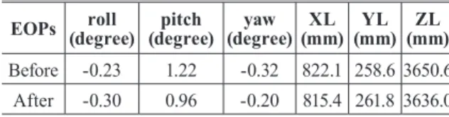
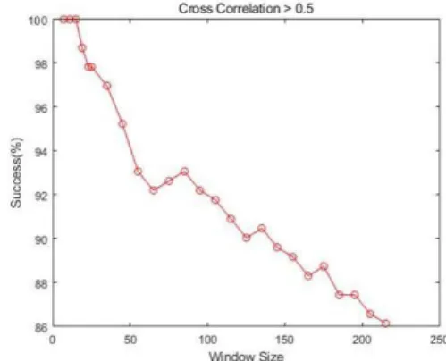
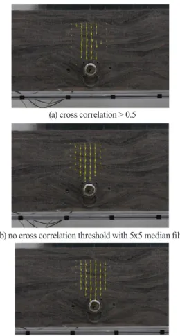
This paper presents soil deformation measurement in model chamber based on photogrammetry. We created an aluminum framed acrylic model chamber with soil inside and applied photogrammetry to measure soil deformation caused by loading tests. The soil consists of 40% black and 60% regular sand to create image contrast in soil images. In preprocessing, the self camera calibration was carried out for IOPs (Interior Orientation Parameters), followed by the space resection to estimate EOPs (Exterior Orientation Parameters) using control points located along the aluminum frame. Image matching was applied to measure the soil displacement. We tested different matching window sizes and the effect of image smoothing. Experimental results showed that 65x65 pixels of window size produced better soil deformation map and the image smoothing was useful to suppress the matching outliers. In conclusion, photogrammetry was able to efficiently generated soil deformation map.
Keywords : Close-range Photogrammetry, Sand Chamber, Pile-load, Soil Deformation, Measurement 초 록
본 논문에서는 근접 사진측량에 기반하여 모형 토조 내 지반의 변위를 측정하기 위한 연구를 진행하였다. 알루
미늄 프레임 및 투명 아크릴로 제작된 실내 모형 토조 내에 토사를 채워 넣고, 하중 재하 장치를 이용한 하중 재하
를 통한 토사의 변위를 사진측량 기법으로 측정하였다. 토조 내의 토사는 영상 기반 자동 매칭을 위하여 검은 모래
약 40%, 일반 모래 약 60% 혼합하여 영상 대비의 정도를 높일 수 있도록 계획하였다. 전처리 과정으로서 실험실 카
메라 캘리브레이션을 통해 내부표정요소를 도출하였고, 토조 프레임에 배치된 기준점을 이용한 후방교회법을 통해
외부표정요소를 예측하였다. 이후 영상 매칭을 통해 하중 전, 후의 토사 변위 패턴을 측정하였으며, 영상 매칭 시
활용되는 매칭 윈도우 크기 및 영상 스무딩 정도를 변경 적용하여 그 결과를 평가해보았다. 실험 결과, 매칭 윈도우
크기 65x65픽셀의 경우 안정적인 변위 도출이 가능하였으며, 영상 스무딩은 매칭의 과대 오차를 감소하는 효과를
보여주었다. 이를 통해 사진 측량을 통한 토조 내 지반 변위 패턴을 도출할 수 있었다.
핵심어 : 근접 사진측량, 모형 토조, 하중 재하, 지반 변위, 계측
555 Received 2019. 11. 28, Revised 2019. 12. 04, Accepted 2019. 12. 05
1) Member, Dept. of Civil Engineering, Seoul National University of Science and Technology (E-mail: [email protected]) 2) Corresponding Author, Member, Dept. of Civil Engineering, Korea Maritime and Ocean University (E-mail: [email protected])
https://doi.org/10.7848/ksgpc.2019.37.6.555 Original article
This is an Open Access article distributed under the terms of the Creative Commons Attribution Non-Commercial License (http://
creativecommons.org/licenses/by-nc/3.0) which permits unrestricted non-commercial use, distribution, and reproduction in any medium, provided the original work is properly cited.