This is an Open Access article distributed under the terms of the Creative Commons Attribution Non-Commercial License (http: //creativecommons.org/licenses/by- nc/4.0/) which permits unrestricted non-commercial use, distribution, and reproduction in any medium, provided the original work is properly cited.
Copyright: © 2018 Korean Journal of Agrcultural Science
PLANT & FOREST
https://doi.org/10.7744/kjoas.20180027
Soil displacement from frost heave on forest road cut-slopes
Myeong-Kyo Lee, Joon-Woo Lee*, Sungmin Choi, Hyoun-Sook Kim
Department of Environment and Forest Resources, Chungnam National University, Daejeon 34134, Korea
*Corresponding author: [email protected]
Introduction
우리나라 산림청에서는
2030
년까지 임도밀도8
.5 m
/ha
달성을 목표로 임도시설의 확대를 추진하 고 있으며(Korea Forest Service
,2010
), 임도의 신설에 중점을 두는 정책을 펼치고 있다(Rhee et al
.,2017
).2017
년 말 기준 우리나라의 임도밀도는3
.2 m
/ha
이며(Korea Forest Service
,2017
), 산림청 의 정책으로 인해 임도사업물량의 지속적인 증가가 예상된다. 이러한 물량 증가에 따라 강우 및 강설 등으로 인해 발생되는 임도재해를 예방하기 위한 견실한 시공이 요구되고 있다. 강우에 의한 임도 비 탈면 침식에 관한 연구사례들과 대조적으로 겨울철 임도 비탈면에서 발생하는 침식에 관한 연구는 잘 이루어지지 않은 실정이다. 그러나 경험론적으로 보았을 때, 임도현장에서 봄철 동상침식으로 인 한 임도 비탈면에서의 토사유출현상이 나타나는 것을 쉽게 볼 수 있다. 겨울철은 다른 계절에 비해 평균온도가 가장 낮으며, 이로 인해 토양 내 수분이 동결될 경우 토양 내 수분의 체적팽창을 통해 동 상(frost heaving
)이 발생하게 된다(Jung
,2003
). 임도의 경우, 절토비탈면과 성토비탈면에서의 동결OPEN ACCESS
Accepted: April 30, 2018 Revised: April 24, 2018 Received: February 19, 2018
Editor: Jungsoo Lee, Kangwon National University, Korea
DOI:
Citation: Lee MK, Lee JW, Choi S, Kim HS. 2018. Soil displacement from frost heave on forest road cut-slopes. Korean Journal of Agricultural Science. https://
doi.org/10.7744/kjoas.20180027
Abstract
The frost heave process from repeated freezing and thawing actions in winter on forest road cut-slopes is important for forest road maintenance and management. This study investigated the damages of the forest heave process on forest road cut-slopes by measuring the changes in the road-cut surface elevation and sediment production and by conducting vegetation surveys which were aimed at providing information for forest road maintenance plans. The temperature and humidity differences were determined between the north and south cut- slopes. T-test showed that the north slope had a lower temperature and humidity than that of the south slope. Field observations also confirmed frozen soils on the north slopes, indicating that the north slopes are susceptible to frost heave. Sediment was converted to dry weight per unit area (g/m
2). T-test showed that the north slope produced more sediment than that of the south slope. The study confirmed that more frost heave occurred on the north cut-slopes than on the south cut-slopes. Vegetation surveys were conducted on five cut-slope plots. Considering the dominant species found above the cut-slopes, vegetations in all the plots are expected to succeed to pine and oak in the future. The dominant species appearing on the cut-slopes of the study area were exotic species because the elapsed time of the site was only 2 - 4 years.
Keywords : frost heave, forest road cut-slope, erosion pin, sediment, vegetation survey
융해작용(
freezing and thawing
)에 의한 동상침식이 발생되며(Woo
,2003
), 이에 따라 겨울철 임도에서 발생하는 동상 침식에 대한 규명과 수치적인 해석이 필요하다.따라서, 본 연구를 통해 겨울철 기후적인 영향과 동결융해작용으로 인해 발생되는 임도 절토비탈면에서의 침식량과 변 화정도를 측정하여 동상침식에 대해 규명하고, 이를 바탕으로 겨울철 임도 절토비탈면의 유지관리에 대한 기초자료를 제공하고자 수행하였다.
Materials and Methods
연구대상지의 개요
연구대상지는 충청남도 금산군 군북면 두두리 산
16
부근에 위치하며, 간선임도시설공사에 의해 개설되어2013
년부터2016
년까지 연차적으로 시공이 이루어진 곳이다. 이 중,2016
년에 개설된 노선은 공사시기와 조사시기의 중복으로 인해 조사가 불가능하여 제외하였으며,2013
년부터2015
년까지 개설된 노선을 대상지로 선정하였다.Lee
(1987
)가 제시한 임 도 비탈면의 침식과 관련된 인자 중, 사면향을 고려하여 토사로 구성된 절토비탈면5
곳을 선정하였으며, 조사구별 물리 적 인자는Table 1
과 같다. 남사면3
곳, 북사면2
곳을 조사구로 선정하였으며, 조사구(측점) 표시는 ‘시공연도-방위’로 기 입하였다.연구시기
동상침식에 대해 연구하기 위해서는 겨울철의 기준을 정의할 필요가 있다. 일반적으로 계절을 구분할 시 기상학적 측 면에서의 계절은 천문계절과 기후계절로 나눌 수 있으며, 우리나라는 북반구 중위도 지역에 속하고, 정상적으로 기후현 상이 천문계절과 일치하지 않아 우리나라 기상학자들은 주로 기후계절을 사용하고 있다(
Lee
,2004
). 따라서, 동상침식을 관찰하는 조사시기는 기후계절상 겨울철인12
월부터 이듬해2
월과 천문계절의 겨울철 시기인3
월을 포함하였으며,12
월부터 이듬해3
월로 연구기간을 설정하여,4
개월 간 총12
회 현장조사를 실시하였다.동상침식량 및 토사유출량 연구방법
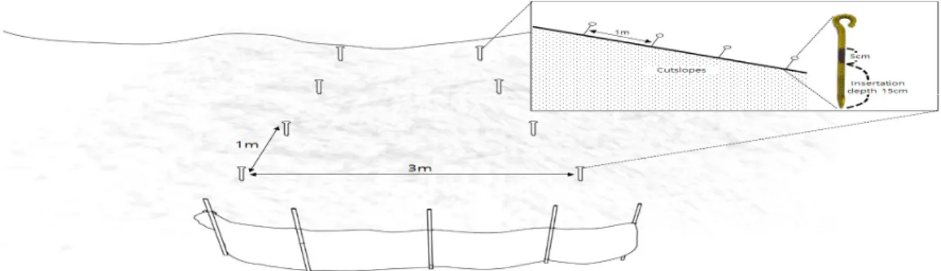
임도 절토비탈면의 동상침식 정도에 대한 정기적인 측정을 위해 침식핀을 설치하였으며, 절토비탈면의 토사유출량을 파악하기 위해 비닐천막을 이용한 포집장치를 설치하였다. 또한 조사구 주변의 식생조사를 위해 3 × 3 m2 크기의 조사구를 설치하였다. Fig. 1과 같이 조사구는 3 m 길이의 각목을 이용하여 정사각형 모양의 모형을 제작하여 좌측과 우측에 일정한 간격(0, 1, 2, 3 m)으로 4개씩, 총 8개의 지점에 침식핀을 설치하였다. 침식핀은 임도 절토비탈면의 수직방향 15 cm 깊이로 설치하였으며, 포집장치는 침식핀 설치지점의 하부위치(측구)에 설치하였다.
절토비탈면에 설치한 조사구의 변화과정을 측정하기 위해, 절토비탈면의 수평방향기준 0 m, 1 m, 2 m, 3 m 지점에 설치한 침식핀의 침식깊이를 측정하였다. 절토비탈면 수평방향의 0 - 3 m 지점에 각각 동일하게 조사를 실시하였으며, 1지점의 비탈면 당 8개에 해당하는 측점의 침식깊이를 조사하였으며, 동상침식 변화량을 나타내는 식은 다음과 같다.
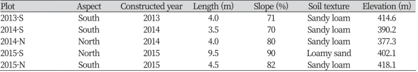
Table 1. Characteristics of the study cut-slopes.
Plot Aspect Constructed year Length (m) Slope (%) Soil texture Elevation (m)
2013-S South 2013 4.0 71 Sandy loam 414.6
2014-S South 2014 3.5 70 Sandy loam 390.2
2014-N North 2014 4.0 80 Sandy loam 377.3
2015-S North 2015 9.5 90 Loamy sand 402.1
2015-N South 2015 4.5 82 Sandy loam 418.1
=
Sum of erosion pins variation
i
=Plots
(2013
-S
,2014
-S
,2014
-N
,2015
-S
,2015
-N
)j
=Ground measurement points
k
=Field observation period
절토비탈면의 침식량 조사는
2016
년12
월부터2017
년3
월까지10
일 간격으로 실시하여 총12
회 조사를 진행하였다.조사 이후, 조사구 간 침식량과 변화량의 차이와 경향을 파악하기 위해
t
-검정을 실시하였다. 토사유출량은 매월 마지막 침식량 조사 시,5
개 지점의 절토비탈면에 설치한 포집장치에 퇴적된 양을 채취하였다. 채취한 토양은1
차적으로 자연건 조를 시킨 후,100
℃의 토양건조기에서72
시간 이상 건조를 실시하였다. 이후 정밀저울로 질량을 측정하여 절토비탈면 의 토사유출량을 추정하였으며, 남사면과 북사면의 단위면적당 토사유출량(g
/m
2)을 계산한 값은t
-검정을 실시하여 분 석하였다.비탈면의 온·습도 조사방법
남사면과 북사면의 온도와 습도차이를 확인하기 위해
2015
년 개설된 임도 남사면과2015
년 개설된 임도 북사면 두 곳 에 온·습도 측정 장비인HOBO Pro v2
(onset
)를 이용하여2017
년1
월28
일부터2
월26
일까지 약1
개월(30
일)간30
분씩 측정간격을 설정하여 온도와 습도변화를 관찰하였다. 관찰종료 후, 남사면과 북사면 간 온도와 습도의 차이를 규명하기 위해t
-검정을 실시하였다.식생조사방법
식생조사는
5
개의 조사구를 대상으로 실시하였으며, 조사구 면적은 종수-면적 곡선(Brower and Zar
,1977
)에 기초하 여 최소면적이상의 크기인10
×10 m
2 (절토비탈면 근접위치),3
×3 m
2 (절토비탈면 소방형구)로 설치하였다. 종 조성 에 입각한 표조작법은Mueller
-Dombois and Ellenberg
(1974
)에 따르며, 절토비탈면 근접위치의 식물사회학적 조사 를 위하여 조사구 내의 출현 식물을 교목층, 아교목층, 관목층 및 초본층으로 구분하고 교목층의 평균수고와 각 층위별 평균피도를 기록하였다. 식물의 학명은Lee
(1996
)와Lee
(1980
)에 따르며, 각 계층별 출현종의 우점도는Braun
-Fig
.1
.A schematic of the plastic fence and erosion control pins on the study cut
-slope
.Blanquet
(1964
)의7
단계 구분을 변형한Dierssen
(1990
)의9
단계 구분법을 적용하여 우점도 및 피도를 조사하였다. 절 토비탈면 소방형구에서는 식피율 및 개체수로 기록하였다.Results and Discussion
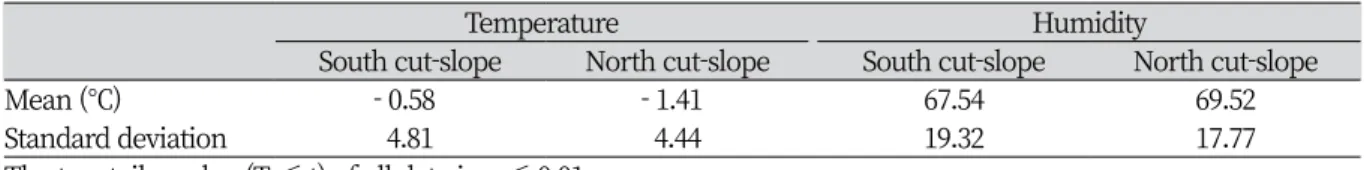
남사면과 북사면의 온·습도 차이
임도의 남사면과 북사면에 설치한 측정장비를 회수하여 분석한 결과
30
일간 총1440
회 기록되었으며, 사면 간t
-검정(쌍체비교)을 실시한 결과, 온도와 습도 모두 사면 간 차이가 있는 것으로 나타났다. 온·습도의 통계분석 결과는
Table 2
와 같다.통계분석 결과를 살펴보면 북사면지역이 남사면지역보다 온도의 평균값이 낮고, 습도의 평균값이 높은 것으로 나타났 으며, 온·습도 모두 오전
8
-10
시 사이에서 다른 시간대에 비해 차이가 많이 발생하는 것으로 나타났다. 이는 일조가 시작 되는 시간의 차이로 인해 나타나는 것으로 판단된다. 이러한 차이를 바탕으로 겨울철의 북사면이 남사면에 비해 비탈면 이 동결되기 쉬운 환경에 노출되는 것으로 나타났다.절토비탈면의 동상침식량 분석
동상침식량 측정을 위해 설치한 침식핀의 변화량은
2014
-N
조사구가49
.7cm
로 가장 큰 변화량 값을 나타내었으며,2015
-N
(30
.8 cm
),2014
-S
(24
.0 cm
),2013
-S
(17
.5 cm
),2015
-S
(12
.7 cm
) 순으로 나타났다. 평균값의 경우, 북사면의 변 화량이 남사면보다 크게 나타났으며, 이러한 차이를 규명하기 위해 조사구별t
검정(이분산 가정 두집단)을 실시한 결과,2014
-N
이2013
-S
과2015
-S
와 차이를 보였다.2015
-N
의 경우 남사면 조사구와 차이를 보이지 않은 이유는 임도 절토비탈 면의 동결깊이가 침식핀 설치깊이(15 cm
)보다 깊게 나타나 비탈면의 동결융해 작용을 받아 침식핀 또한 동상침식으로 인해 움직였을 것으로 판단된다. 또한2014
-S
의 경우 초본류의 피복으로 인해 측정과정에서의 오류가 발생된 것으로 판 단된다. 하지만 현장조사 시 남사면과 달리 북사면에서의 동결현상을 육안으로 확인할 수 있었다(Fig
.2
).절토비탈면의 토사유출량 분석
조사구의 비탈면 토사유출량을 계산한 결과, 북사면의 조사구(
2015
-N
,2014
-N
)가 남사면의 조사구(2015
-S
,2014
-S
,2013
-S
) 보다 높은 수치를 보였으며,2014
-N
에서 발생한 양이2015
-N
에서 발생한 양보다 높은 수치를 보였다.2015
-N
이2014
-N
보다 비탈면의 길이가 길고 경사가 더 급하기 때문에 토사유출량이 클 것으로 예상됐으나,2014
-N
이 더 큰 것으 로 나타났다. 이는 비탈면의 선형 등 다른 물리적 인자를 고려하지 못하였거나 비탈면 토양 내 수분함유량의 차이, 또는 표본의 수가 적었기 때문인 것으로 판단된다.Table 3
은 남사면과 북사면의 비탈면 면적당 토사유출량을 계산한 값에 대 해 조사구별t
-검정(이분산 가정 두집단)을 실시한 결과로서, 남사면과 북사면이 차이를 보였다. 따라서, 겨울철에는 북사 면의 토사유출량이 남사면 보다 더 큰 것으로 나타났다.Table 2. T-test results of temperature and humidity by slope.
Temperature Humidity
South cut-slope North cut-slope South cut-slope North cut-slope
Mean (℃) - 0.58 - 1.41 67.54 69.52
Standard deviation 4.81 4.44 19.32 17.77
The two-tail p value (T ≤ t) of all data is p ≤ 0.01.
조사구별 식생조사 결과 분석
Table 4
는 절토비탈면 근접10
×10
조사구의 일반환경 및 식생이며 모든 조사구에서 토색(회갈색), 종조성(혼효림)과 산림형태(이차림), 토습(건조)은 동일하게 나타났다.2013
-S
와2015
-S
은 소나무류 군락이며,2014
-S
,2014
-N
,2015
-N
은 참나무류 군락인 것으로 나타났다.Table 5
는 비탈면3
×3
조사구의 일반환경 및 식생이며 모든 조사구에서 토색(회갈색)은 동일하게 나타났다.2015
-N
을 제외한 모든 조사구에서의 우점종은 임도시공 시 파종되었던 외래초종(큰김의털, 호밀풀, 능수참새그령)인 것으로 나 타났다.절토비탈면 소방형구 식생을 분석해 본 결과, 북사면보다 남사면에서 식피율이 높게 나타났으며, 북사면에서는 토사 유출로 인해 파종한 종들의 활착률이 낮아 식피율이 현저히 낮게 나타났으나, 추후 근접사면의 우점분류군에 의해 천이 가 일어날 것으로 사료된다. 따라서, 임도 절토비탈면에 녹화공을 실시할 경우, 토사유출에 대한 안정성과 향후 주변 식 생에 따른 천이를 고려할 필요성이 있다.연구대상지 절토비탈면에 나타난 대부분의 외래초종과 싸리류는 임도시공 시 인위적으로 파종된 혼합종자이며, 비탈면의 녹화용도로 사용된 것으로 조사되었다. 임도시공 후 초본류와 목본류의 침 입으로 생태적인 천이가 진행되며(
Lee et al
.,2003
), 파종된 외래초종의 출현이 낮아지게 된다. 따라서 연구대상지의 북 사면은 식생피복이 낮으나 선행된 연구에 따르면 천이과정이 남사면보다 빠르기 때문에 비탈면의 안정성 측면에서 향후 관찰이 필요하며, 남사면은 양호한 식피율로 인해 시공초기의 안정성은 높으나 과도 파종이 되었을 수 있기 때문에 정상 적인 속도로 천이가 진행되는지 모니터링 해 볼 필요성이 있다.Fig . 2 . Frost heave of the north cut
-slopes
.Table 3. T-test results of sediment production.
Sediment production
South cut-slope North cut-slope
Mean (g/㎡) 81.19 780.88
Standard deviation 85.82293 260.1373
The two-tail p value (T ≤ t) of all data is p ≤ 0.01.
Table 4. Physical and vegetative characteristics by 10 × 10 m
2plot.
Survey plot 2013-S 2014-S 2014-N 2015-S 2015-N
Colony Pinus densiflora Quercus aliena Quercus serrata Pinus densiflora Quercus mongolica
Coordinate N 36°10′30.2″ N 36°10′27.8″ N 36°10′22.5″ N 36°09′48.0″ N 36°09′27.7″
E127°32′40.8″ E127°32′78.0″ E127°32′43.6″ E127°32′34.2″ E127°32′34.0″
Altitude (m) 414.6 390.2 377.3 418.1 402.1
Bearing/Slope (%) S/71 S/70 N/80 S/82 N/90
Vegetation cover (%)
Tree layer 75 85 80 80 85
Sub-tree layer 30 40 40 15 50
Shrub layer 25 80 70 40 60
Herbaceous layer 35 60 40 50 30
Encountered species
Tree layer Pinus densiflora,
Quercus serrata Quercus aliena, Quercus serrata, Pinus densiflora, Alnus sibirica,
Quercus serrata, Pinus densiflora, Alnus sibirica, Quercus aliena
Pinus densiflora,
Quercus dentata Quercus mongolica, Pinus densiflora Pinus rigida
Sub-tree layer Quercus serrata, Juniperus rigida, Prunus serrulata var.
pubescens,
Quercus aliena,
Quercus serrata Quercus aliena, Quercus variabilis, Alnus sibirica, Juniperus rigida
Quercus dentata, Juniperus rigida, Quercus aliena, Robinia pseudoacacia,
Quercus mongolica, Juniperus rigida
Pinus densiflora Pinus densiflora
Shrub layer Juniperus rigida, Quercus serrata, Pinus densiflora, Prunus serrulata var.
pubescens,
Zanthoxylum schinifolium, Ligustrum obtusifolium, Quercus aliena, Quercus serrata, Quercus variabilis, Euonymus alatus, Alnus sibirica, Lindera obtusiloba, Rhus trichocarpa, Elaeagnus umbellata
Rhododendron schlippenbachii, Rhododendron mucronulatum, Lindera obtusiloba, Quercus serrata, Prunus sargentii, Quercus mongolica, Juniperus rigida, Quercus variabilis, Robinia pseudoacacia, Lindera erythrocarpa, Zanthoxylum schinifolium
Juniperus rigida, Robinia pseudoacacia, Lindera obtusiloba
Rhododendron mucronulatum, Juniperus rigida, Quercus mongolica Lindera obtusiloba,
Lespedeza bicolor, Zanthoxylum schinifolium
Herbaceous layer Pteridium aquilinum var.
latiusculum, Quercus variabilis, Smilax china,
Quercus aliena, Quercus serrata, Dictamnus dasycarpus,
Rhododendron schlippenbachii, Rhododendron mucronulatum, Smilax china, Quercus serrata, Quercus aliena, Quercus variabilis, Pteridium aquilinum var. latiusculum, Carex ciliatomarginata, Prunus sargentii, Pinus densiflora, Pyrola japonica, Viola mandshurica, Zanthoxylum schinifolium,
Quercus variabilis, Quercus dentata, Rhododendron yedoense, Robinia pseudoacacia, Quercus aliena, Ampelopsis brevipedunculata f.
citrulloides, Ligustrum obtusifolium,
Rhododendron mucronulatum, Quercus mongolica, Juniperus rigida, Carex ciliatomarginata, Pyrola japonica, Quercus variabilis, Cephalanthera longibracteata,
Carex lanceolata, Quercus aliena, Prunus serrulata var.
pubescens,
Pueraria lobata, Clematis apiifolia, Lespedeza bicolor, Carex lanceolata, Spiraea prunifolia f. simpliciflora,
Rubus crataegifolius, Staphylea bumalda, Potentilla fragarioides var.
major,
Carex siderosticta, Pteridium aquilinum var.
latiusculum, Quercus acutissima, Carex lanceolata, Pinus densiflora, Sorbus alnifolia, Prunus sargentii, Atractylodes ovata, Lindera obtusiloba, Juniperus rigida
Iris rossii,
Lindera obtusiloba, Rhododendron mucronulatum, Rubus crataegifolius, Spodiopogon cotulifer, Zanthoxylum schinifolium, Lespedeza bicolor, Pinus densiflora, Disporum smilacinum,
Vicia amoena, Arundinella hirta and 9 other species Lindera obtusiloba, Prunus sargentii, Pteridium aquilinum var. latiusculum, Carex lanceolata, Lilium lancifolium, Atractylodes ovata, Corydalis speciosa, Rhododendron yedoense, Lindera erythrocarpa,
Parthenocissus tricuspidataRhus trichocarpa, Celastrus flagellaris, Parthenocissus tricuspidata, Ligustrum obtusifolium,
Artemisia stolonifera
Iris rossii,
Thalictrum filamentosum var. tenerum, Arundinella hirta, Prunus sargentii, Smilax sieboldii, Veratrum maackii var.
japonicum and 7 other species
The bold type is dominant species in each plots. All research site’s topography are cut-slope and soil color are taupe. All research site’s species composision are mixed forest and forest type are secondary forest. All research site’s radiation are normal and soil humidity are dry.
Conclusion
본 연구는 겨울철 임도 절토비탈면에서 발생하는 동상침식의 기작과 관련하여 수치적인 자료 제공을 통해 겨울철 임 도 사면향에 따른 절토비탈면 침식 정도를 규명하였다.
남사면과 북사면의 온·습도를 비교·분석한 결과, 북사면의 비탈면이 동결에 더 취약한 환경인 것으로 나타났다. 또한, 겨울철 임도 절토비탈면의 침식량 변화와 토사유출량을 분석한 결과, 침식량과 토사유출량(
g
/m
2) 모두 북사면이 남사면 보다 큰 것으로 나타났다.절토비탈면 식생의 경우 연구대상지는 시공경과년수가
2
-4
년으로, 경과년수가 비교적 짧은 임도를 대상으로 실시하 였기 때문에 향후 천이과정을 예측하고자, 조사구를 대상으로 절토비탈면의 녹화에 쓰였던 외래초종의 피복도와 절토비 탈면 상단의 식생조사를 실시하였다. 그 결과, 파종된 외래초종은 남사면의 절토비탈면이 북사면의 절토비탈면에 비해 피복도가 높게 나타났다.Lee et al
. (2003
)의 선행 연구 결과에 따르면, 임도 북사면의 절토비탈면이 남사면의 절토비탈 면에 비해 식생천이가 비교적 먼저 진행되는 것으로 나타났으며, 이를 본 연구 결과로 유추해 볼 때, 북사면의 절토비탈 면에서 동상침식이 많이 발생하여 빠르게 안식각을 형성하고 임도시공 시 파종하였던 외래초종을 이탈시킴으로 인해, 주변 임상으로부터의 자연 천이가 진행되었기 때문인 것으로 사료된다.따라서, 절토비탈면의 안정적인 측면을 고려할 경우, 북사면의 절토비탈면이 남사면의 절토비탈면에 비해 동상침식이 활발하게 일어나기 때문에, 이를 방지하기 위해 북사면 절토비탈면은 분사식 녹화공법을 적용하기 보다는 식생의 활착 이 양호하고 단열효과가 높은 떼붙임 녹화공법을 통해 안정성을 도모할 필요성이 있는 것으로 판단된다(
Yang et al
.,2007
).절토비탈면의 동상침식 이외에도 겨울철의 기온강하로 인한 임도에서 발생하는 동결현상은 임도의 노면에도 나타나 는 것을 발견할 수 있었다. 노면부는 차량이 지나간 흔적이 그대로 노면이 동결되어 통행에 불편함을 초래하였으며, 종단
Table 5. Physical and vegetative characteristics by 3 × 3 m
2plot.
Survey Plot 2013-S 2014-S 2014-N 2015-S 2015-N
Coordinate N 36°10′30.2″ N 36°10′27.8″ N 36°10′22.5″ N 36°09′48.0″ N 36°09′27.7″
E127°32′40.8″ E127°32′78.0″ E127°32′43.6″ E127°32′34.2″ E127°32′34.0″
Altitude (m) 414.6 390.2 377.3 418.1 402.1
Bearing/Slope (%) S/71 S/70 N/80 S/82 N/90
Vegetation cover (%) 75 85 10 30 0
Herbaceous layer Festuca
arundinacea 55%, Eragrostis curvula 1%,
Festuca
arundinacea 70%, Lolium perenne
5%, Eragrostis curvula 5%,
Eragrostis curvula 5%, 1 Alnus sibirica, 1 Pinus densiflora,
Festuca
arundinacea 5%, Lolium perenne
20%, Eragrostis curvula , 5%,
※ Plants do not grow due to sediment 1 Pinus densiflora, 1 Erigeron
annuus, 1 Robinia
pseudoacacia 3 Lysimachia clethroides, 1 Lespedeza
bicolor, 2 Lespedeza
bicolor, 2 Lespedeza
bicolor, 2 Alnus sibirica 2 Zanthoxylum
schinifolium, 1 Robinia
pseudoacacia 1 Quercus aliena,
1 Rubus crataegifolius
The bold type is dominant species in each plots. All research site’s topography are cut-slope and soil color are
taupe. All research site’s radiation are normal and soil humidity are dry.
Acknowledgements
이 연구는 충남대학교 학술연구비에 의해 지원되었습니다.
References
Braun-Blanquet J. 1964. Pflanzensoziologie-grundzüge der vegetationskunde. Springer-Verlag, Newyork, USA. [in German] 10.1007/978-3-7091-8110-2
Brower JE, Zar JH. 1977. Field and laboratory methods for general ecology. Wm. C. Brown Company Public, Iowa, USA.
Dierssen K. 1990. Einführung in die pflanzensoziologie. Akademie-Verlag, Berlin, Germany. [in German]
Jung ST. 2003. Soil physics. Construction information company, Seoul, Korea. [in Korean]
Korea Forest Service. 2010. Forest road facilities Master Plan. p. 136 [in Korean]
Korea Forest Service. 2017. Statistical Yearbook of Forestry in 2017. p. 233 [in Korean]
Lee GH. 2004. Human and climate environment. SigmaPress, Seoul, Korea. [in Korean]
Lee JW. 1987. The study on the cut slope stability in forest road. M.S. thesis, Seoul National Univ., Seoul, Korea. [in Korean]
Lee MJ, Song HK, Lee JW, Jeon KS, Kim HJ, Jung DH. 2003. Vegetation succession in the cut-slope of forest road In case study on Chungcheong-do. Journal of Korean Forest Society 92:397-408. [in Korean]
Lee WC. 1996. Coloured wild plants of korea. Academy book, Seoul, Korea. [in Korean]
Lee TB. 1980. Illustrated flora of Korea. Hangmunsa, Seoul, Korea. [in Korean]
Mueller-Dombois D, Ellenberg H. 1974. Aims and methods of vegetation ecology. John Wiley and sons, Newyork, USA.
Rhee H, Choi S, Lee JW, Kweon HK. 2017. Comparison of forest road status and policies between Korea and United States. Korean Journal of Agricultural Science 44:504-512. [in Korean]
Woo BM. 2003. Environmental restoration and revegetation engineering. SNUPRESS, Seoul, Korea. [in Korean]
Yang M, Rui D, Ueno K, Suzuki T, Yamashita S. 2007. Behavior ofsodding slope in freeze-thaw process and countermeasure for frost heaving damage. Kitami Institute of Technology Repository 47:205-210. [in Japanese]
기울기가 급한 지역에 콘크리트 포장을 실시한 구간이 동결될 경우 자칫 인명피해가 발생될 수 있을 정도로 위험한 상황 에 노출 되는 것으로 보인다. 따라서, 본 연구에서 비교·분석한 임도 절토비탈면의 사면향 이외에도 비탈면의 경사, 비탈 면의 길이, 노체 및 노면, 식생피복상태 등 동상침식과 관련한 물리적 인자와 관련된 다양한 구체적인 연구가 필요할 것 으로 사료된다.