효과적인 토양유실 방지대책 수립을 위한 유사평가툴
Enhanced Sediment Assessment Tool for Effective Erosion Control임경재*
, Bernard A. Engel**, 최예환*, 최중대*, 김기성*, 신용철*, 허성구*, 류창원*
Kyoung Jae Lim, Bernard A. Engel, Ye-Hwan Choi, Joongdae Choi, Ki-Sung Kim, Yong-Cheol Shin, Sung-Gu, Heo, Changwon Lyou
*강원대학교 지역기반공학과
**퍼듀대학교 농공학과 인디애나 미국
, ,
Abstract: Accelerated soil erosion is a worldwide problem because of its economic and environmental impacts. To effectively estimate soil erosion and to establish soil erosion management plans, many computer models have been developed and used. The Revised Universal Soil Loss Equation (RUSLE) has been used in many countries, and input parameter data for RUSLE have been well established over the years. However, the RUSLE cannot be used to estimate the sediment yield for a watershed. Thus, the GIS-based Sediment Assessment Tool for Effective Erosion Control (SATEEC) was developed to estimate soil loss and sediment yield for any location within a watershed using the RUSLE and a spatially distributed sediment delivery ratio. SATEEC was enhanced in this study by developing new modules to:1) simulate the effects of sediment retention basins on the receiving water bodies, 2) prepare input parameters for the Web-based sediment decision support system using a GIS interface. This easy-to-operate SATEEC system can be used to identify areas vulnerable to soil loss and to develop efficient soil erosion management plans.
Keywords: Soil Erosion, Sediment Delivery Ratio, Sediment Yield, USLE
1. INTRODUCTION
Accelerated soil erosion is a serious concern worldwide, and it is difficult to assess its economic and environmental impacts accurately because of its extent, magnitude, rate, and complex processes associated with it (Lal, 1994). Soil erosion is a natural process and it refers to processes by which earth materials are entrained and transported across a given surface. Due to the possible on-site deposition of soil materials due to changes in topography, vegetation, and soil characteristics, soil loss is usually less than soil erosion. Thus, sediment yield is used to refer to the amount of eroded material that is actually transported from a plot, field, channel, or watershed. To estimate soil erosion and to develop optimal soil erosion management plans, many erosion models, such as Universal Soil Loss Equation (USLE), Water Erosion Prediction Project (WEPP), and Soil and Water Assessment Tool (SWAT) have been developed and used over the years. Among these models, the USLE has remained the most practical method of estimating soil erosion potential in fields and to estimate the effects of different control management practices on soil erosion for nearly 40 years (Kinnell, 2000) while other process-based erosion models have intensive data and computation requirements. The USLE has been used/integrated with Geographic Information Systems (GIS) to estimate soil
erosion because GIS helps users manipulate and analyze the spatial data easily, and it also helps users identify the spatial locations vulnerable to soil erosion (Ouyang and Bartholic, 2001). However, these studies using the USLE didn't consider the sediment delivery ratio to estimate the sediment delivered to the downstream point of interest. Regional variations in sediment yields are very important since sediment delivery processes vary in space and time. Thus, a GIS integrated prototype version of the Sediment Assessment Tool for Effective Erosion Control (SATEEC) (Lim et al., 2003) was developed to estimate soil erosion and sediment yield without additional input parameter data other than those for the USLE. With the USLE input parameter, the SATEEC can estimate soil erosion and the sediment yield at any point within a watershed with a menu-driven SATEEC GIS interface (Lim et al., 2003). Soil loss is estimated with the RUSLE, and a spatially distributed sediment yield map is generated with the RUSLE estimated soil loss and the spatially distributed sediment delivery ratio map. However, this SATEEC GIS system cannot be used to assess the effects of sediment retention basins on the sediment yield of the receiving water bodies. Also, the SATEEC GIS system does not have any sediment and erosion control structure design capability.
The objectives of this study were to enhance the prototype version of the SATEEC GIS system by developing new modules to:
1) simulate the impact of sediment retention basins on the sediment yield;
2) provide a GIS interface to the Web-based sediment decision support system for sediment retention basin design.
2. Enhancement of the SATEEC GIS System
2.1. Assessment of Effects of Sediment Retention Basin on Downstream Water
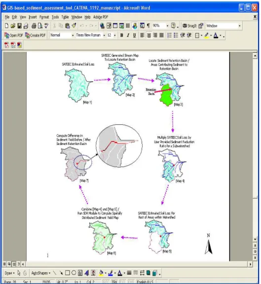
A new module to assess the effects of sediment retention basins on downstream sediment yield was developed and added to the SATEEC GIS system with Avenue programming. Figure 1 shows how the enhanced SATEEC system estimates the effects of sediment retention basins on downstream water bodies. First the SATEEC estimates soil loss by multiplying R, K, LS that was calculated from the DEM, C, and P factor maps together (Map 1 in Figure 1). The SATEEC estimated soil loss map shows the soil loss potentials in kg/ha/year. SATEEC provides a "Generate Stream with User Specified Threshold Value" option to allow users to generate stream maps within the study area (Map 2 in Figure 1). This stream map, as well as the soil loss map generated in previous step, can complement the selection of potential locations for the sediment retention basin within the study area to estimate the effects of sediment retention basins on downstream water bodies. Once users select the potential location for a sediment retention basin, the SATEEC requests the sediment reduction ratio for the retention basin. Then, the SATEEC delineates the subwatershed for the retention basin to quantify the sediment load contribution (Map 3 in Figure 1). With the sediment reduction ratio value, the SATEEC GIS system computes the sediment reduction with the retention basin for the subwatershed (Map 4 in Figure 1). SATEEC also estimates soil loss for the entire study area (Map 5 in Figure 1). SATEEC then combines maps generated in steps 4 and 5 (Maps 4 and 5 in Figure 1) and runs the SDR module to compute the spatially distributed sediment yield map (Map 6 in Figure 1). The Map 6 in Figure 1 shows the sediment yield
map for the entire study area after installing a sediment retention basin. The difference in the sediment yields before the sediment retention basin (Map 2 in Figure 1) and after the sediment retention basin (Map 6 in Figure 1) is computed to provide the spatial impacts of the sediment retention basin on downstream water bodies (Map 7 in Figure 1). It is worth noting that there is no difference in the sediment yield of the tributaries (white cells on the tributaries, Map 7 in Figure 1). Thus, the module developed in this study is useful as a screening tool to locate potential sediment retention basins and estimate their impacts on downstream water bodies.
Figure 1 How SATEEC Estimates the Effects of Sediment Retention Basins on Downstream Water Bodies
2.2. Development of GIS Interface to the Web-based SEDSPEC System
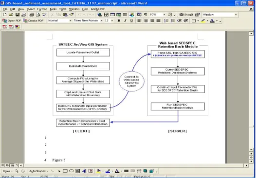
The Web-based SEDSPEC system (http://pasture.ecn.purdue.edu/~sedspec Tang et al., 2004) can be used to design hydrologic and erosion control structures. Thus, the GIS interface to the Web-based SEDSPEC system was developed and integrated with the SATEEC GIS system to facilitate the input data preparation for sediment retention basin design with Avenue, Perl CGI, and SQL programming and spatial GIS data sets. This module allows the user to define the point of interest as a watershed outlet, and it computes input parameter values for
the SEDSPEC system, such as flow length and average slope of the watershed, unique combination of land use and hydrologic soil group, and area for each combination for the design of sediment retention basins. The SEDSPEC module customized for the SATEEC (http://pasture.ecn.purdue.edu/~sedspec/SATEEC) computes all possible sediment retention basin dimensions, and displays adequate storage of runoff and sediment, cost, maintenance, and technical information in the output interface. Figure 2 shows how the SATEEC can be used to design the sediment retention basin using the Web-based SEDSPEC system.
Figure 2. Interface to the Web-based SEDSPEC from the SATEEC System
3. RESULTS AND CONCLUSIONS
The SATEEC system was enhanced with additional functions incorporated in the SATEEC menus to simulate the effects of sediment retention basins in the watershed and provide a GIS interface to the Web-based SEDSPEC retention basin module. SATEEC Version 1.5 is available in the ArcView GIS project file format; however, efforts are underway to create an ArcView Extension to facilitate installation on desktop computers.
Soil erosion management plans need to be targeted to the major problem areas rather than to the entire region of interest. Thus, this easy-to-use SATEEC GIS system can be used by soil erosion decision makers to estimate soil loss and sediment yield, to identify areas vulnerable to soil loss, and to establish efficient erosion control plans with a fully automated menu driven system. Although the enhanced SATEEC is an efficient tool for soil erosion management, SATEEC does not estimate soil loss from gully and channel erosion processes. Thus, it should not be used for large watersheds if the soil loss from gullies and channels is dominant.
REFERENCES
pollution model. Environmental Modeling & Software, 15(2000): 331-341.
Lal, R., 1994. Soil erosion by wind and water: problems and prospects. In R. Lal (editor), Soil erosion research methods. Second Edition. Soil and Water Conservation Society, St. Lucie Press. Delray Beach, FL.
Lim, K.J., Choi, J., Kim, K, Sagong, M., Engel., B. A., 2003. Development of sediment assessment tool for effective erosion control (SATEEC) in small scale watershed. The Transactions of the Korean Society of Agricultural Engineers, 45(5): 85-96.
Ouyand, D., Bartholic, J., 2001. Web-based GIS application for soil erosion prediction. Proceedings of An International Symposium - Soil Erosion Research for the 21st Century. Honolulu, HI. Jan. 3-5, 2001. Tang, Z., Engel, B. A., Choi, J., Sullivan, K., Sharif, M., Lim, K. J., 2004. A Web-based DSS for erosion control structure planning. Applied Engineering in Agriculture, 20(5): 707-714.