Aerospace technology generally refers to the development and utilization of aircraft, satellites, space vehicles, and peripheral equipment including sensors. A notable development in aerospace
technology includes unmanned aerial systems (a.k.a. drones) and associated policies that allow agricultural practitioners and researchers to use the technology safely and legally (Kim et al., 2021). Along with aerospace technology, geospatial technology is used to collect, process, analyze, and present geospatial data (Park et al., 2007). The technology generally involves global
Review KOREAN JOURNAL OF APPLIED ENTOMOLOGY
한국응용곤충학회지 ⓒ The Korean Society of Applied Entomology
Korean J. Appl. Entomol. 60(1): 135-143 (2021) pISSN 1225-0171, eISSN 2287-545X
DOI: https://doi.org/10.5656/KSAE.2021.02.0.009
Advances, Limitations, and Future Applications of Aerospace and
Geospatial Technologies for Apple IPM
Yong-Lak Park, Jum Rae Cho1, Kyung-Hee Choi3, Hyun Ran Kim1, Ji Won Kim5, Se Jin Kim4, Dong-Hyuk Lee2, Chang-Gyu Park6 and Young Sik Cho2*
Entomology Program, Division of Plant and Soil Sciences, West Virginia University, Morgantown 26506, USA
1Crop Protection Division, National Institute of Agricultural Sciences, Rural Development Administration, Wanju 55365, Korea 2Apple Research Institute, National Institute of Horticulture and Herbal Science, Rural Development Administration, Gunwi 39000, Korea
3Research Policy Bureau, Rural Development Administration, Jeonju 54875, Korea
4Floriculture Research Division, National Institute of Horticultural and Herbal Science, Rural Development Administration, Wanju 55365, Korea 5Division of Agricultural Environment Research, Gyeongsangbuk-do Agricultural Research & Extension Services, Daegu 41404, Korea
6Korea National College of Agriculture and Fisheries, Jeonju 54874, Korea
사과 IPM을 위한 항공 및 지리정보 기술의 진보, 제한 및 미래 응용
박용락ㆍ조점래1ㆍ최경희3ㆍ김현란1ㆍ김지원5ㆍ김세진4ㆍ이동혁2ㆍ박창규6ㆍ조영식2*
웨스트 버지니아대학교, 1국립농업과학원 작물보호과, 2국립원예특작과학원 사과연구소, 3농촌진흥청 연구운영과, 4국립원예특작과학원 화훼과, 5경상북도농업기술원 농업환경연구과, 6한국농수산대학교
ABSTRACT: Aerospace and geospatial technologies have become more accessible by researchers and agricultural practitioners, and these technologies can play a pivotal role in transforming current pest management practices in agriculture and forestry. During the past 20 years, technologies including satellites, manned and unmanned aircraft, spectral sensors, information systems, and autonomous field equipment, have been used to detect pests and apply control measures site-specifically. Despite the availability of aerospace and geospatial technologies, along with big-data-driven artificial intelligence, applications of such technologies to apple IPM have not been realized yet. Using a case study conducted at the Korea Apple Research Institute, this article discusses the advances and limitations of current aerospace and geospatial technologies that can be used for improving apple IPM.
Key words: satellites, drone, remote sensing, geographic information system, artificial intelligence, apple IPM
초 록: 항공 및 지리 공간 기술은 연구자 및 농업관련 실무자들이 더욱더 쉽게 접근할 수 있게 되었으며, 이러한 기술은 농업과 임업에 있어 현재 병해 충 관리의 변화에 중추적인 역할을 할 수 있다. 지난 20년 동안 위성, 유무인항공기, 스펙트럼 센서들, 정보 시스템 및 자동화 현장 장비들의 기술들 은 병해충을 감지하고, 특정 지점에 대한 병해충을 방제하는데 사용되어져 왔다. 빅 데이터 기반한 인공 지능과 함께 항공 및 지리 정보 기술의 가용 함에도 불구하고 이러한 기술을 사과 IPM에 적용하는 것은 아직 실현되지 않았다. 본 논문은 사과연구소에서 수행한 사례 연구를 통해 사과 IPM 개선에 활용할 수 있는 항공 및 지리 정보기술의 발전과 한계에 대해 논하고자 한다. 검색어: 위성, 드론, 원격 탐지, 지리정보시스템, 인공지능, 사과 IPM
*Corresponding author: [email protected]
Received January 31 2021; Revised February 18 2021 Accepted February 25 2021
positioning systems (GPS), geographical information systems (GIS), and remote and proximal sensing (Park and Tollefson, 2005). The use of aerospace and geospatial technologies together has created a novel and attractive tool, and these technologies indeed have been transforming agriculture during the past 20 years (Park et al., 2018; Filho et al., 2020).
When aerospace and geospatial technologies are used for pest management, each technology exhibits advantages and disadvantages. Satellites can monitor pests in large geographic areas such as countries and provinces, while their spatial resolution may not be high enough to detect minor or local pest damages (Moran et al., 1997). Manned airplanes can achieve regional- scale pest surveys and also apply control measures such as pesticides; however, it carries a risk of a crash, which can cause human or property losses (Park et al., 2018). Alternatively, small drones offer safe and versatile tools for orchard-scale pest surveys and also can apply control measures site-specifically within an orchard (Filho et al., 2020). However, large-scale pest monitoring or application of control measures with drones is still very challenging in many cropping systems. Specifically, aerospace and geospatial technologies have not been widely adopted for apple IPM, although numerous previous studies have been conducted in other cropping systems for pest detection and management (Mogili and Deepak, 2018; Zhang et al., 2019; Filho et al., 2020).
This article reviews and presents the potentials and limitations of aerospace and geospatial technologies (i.e., satellite, drone,
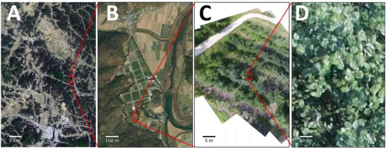
remote sensing, and information system) for apple IPM. By using a case study in apple orchards, this article addresses (1) monitoring and survey of pests by using satellites, drones, remote sensing, and GIS, (2) application of control measures by using aerospace technology, and (3) potential of artificial intelligence and machine learning to apple IPM. The aerial imageries of satellites and drones presented in this article were collected in 2018–2020 at the Korea Apple Research Institute (KARI) located in Gunwi, Republic of Korea. The KARI was founded in 1991 under the Rural Development Administration of the Republic of Korea (Fig. 1) with the missions of apple research include breeding, production systems, and IPM.
Application of Remote Sensing Technology
for Pest Detection in Apple Orchards
Remote sensing provides a possible solution to extensive and intensive pest surveys at multiple spatial scales (i.e., from continents to individual plants) in a timely manner (see Fig. 1 for example). In general, remote sensing in agriculture uses optical sensors onboard a satellite, aircraft, or drone without physical contact with target crops (Lillesand and Kiefer, 2000), which can provide information about the physical and physio-logical condition of crops (Bauer, 1985; Curran, 1985; Clevers, 1999). The optical sensors include, but are not limited to natural-color, near-infrared, multi-spectral, hyperspectral, and thermal sensors. Spectral or optical resolution varies depending
Fig. 1. Example aerial imageries acquired with various aerospace and geospatial technologies. A, Landsat satellite imagery around the Korea Apple Research Institute (KARI, red box); B, SPOT satellite imagery of the KARI (outlined); C, a composite drone image of a specialty-apple plot in the KARI; D, a high-resolution image of the canopy of an apple tree.
on the flight altitude, weather, and sensors used to obtain the data or imagery. Common multispectral imagery includes wave-lengths in the visible (380–700 nm), infrared (700–1,400 nm), and thermal (> 1,400 nm) ranges. Earlier entomological studies (Brewster et al., 1999; Fitzgerald et al., 2004; Yang et al., 2005) indicated that remote sensing would offer many potential benefits to growers and should continue to be an active area of research for many years. However, there have been relatively few published studies regarding pest detection in apple orchards by using remote sensing. Here, we review the use of aerospace and geospatial technologies related to apple IPM with a case study conducted at the KARI with remote sensing using satellites, drones, sensors, and geographic information system (GIS) to detect insects, plant diseases, and weeds in apple orchards.
Remote Sensing with Satellites
Satellites have been widely used for remote sensing to conduct large-scale crop monitoring (Moran et al., 1997). For example, Landsat satellites carry multiple sensors, including natural color (i.e., RGB), near-infrared (NIR), and thermal
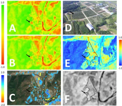
sensors. The sensors can be used to detect spectral reflectance from vegetation that is significantly influenced by leaf pigments, cell structure, and cell water content (Jensen, 1983). Reductions of pigments (i.e., chlorophylls a and b, anthocyanin, and carotenoids) in plant tissues could be associated with herbi-vorous insects. Changes in the amount of the pigments could be detected by using a vegetation index, a combination of remotely-sensed imageries at different wavelengths. The most commonly used vegetation index is the normalized difference vegetation index (NDVI). The NDVI values range from -1 to 1 and correspond to the condition of vegetation; low values correspond to barren fields, moderate values represent shrub and grassland, and high values indicate dense vegetation. For example, NIDVI is generated by using imageries from both NIR and red lights (Fig. 2A and B). Differences in NDVI values between 2019 and 2020 maps of apple orchards in the KARI (Fig. 3C) showed an increase of NDVI values (i.e., blue pixels) in some apple plots, indicating vegetation condition improved from 2019 to 2020. The change can be further inves-tigated and confirmed with drone imagery (Fig. 3D), thermal imagery (Fig. 3E), and NIR imagery (Fig. 3F). These maps can
Fig. 2. Normalized difference vegetation index (NDVI) maps of the KARI (outlined) in May 2019 (A) and May 2020 (B) generated by using remotely sensed data by MODIS sensors equipped on Landsat satellites. The difference of each pixel in A and B was calculated to determine changes in vegetation between the two years (C; higher values indicating improvement of vegetation from 2019 to 2020). RBG (D), thermal (E, relative surface temperature), and NIR (F) sensors were used to generate additional aerial images to further examine the changes in land use and vegetation. Black arrows indicate a specific apple plot of which vegetation index was increased between 2019 and 2020.
be used to determine a large-scale change of vegetation in multiple apple orchards and to identify areas for more detailed surveys with drones or ground-truthing.
Remote sensing with satellites has multiple advantages for apple IPM. Satellites with various sensors orbit the Earth regularly and repeatedly (e.g., Landsat satellites 7 and 8 repeating their orbital pattern every 16 days), and thus a planned large-scale pest monitoring is possible. Two major disadvantages would be a limited spatial resolution (e.g., the spatial resolution of Landsat satellites in Figs. 1 and 2 is 30 m by 30 m) and weather- dependent image quality (e.g., cloud cover). Currently, three Korean government agencies (i.e., Rural Development Admin-istration, Ministry of Science and ICT, and Korea Forest Science) plan to launch a satellite for agriculture and forestry in 2023, which could help a large-scale apple pest monitoring and IPM in the Republic of Korea.
Remote Sensing with Drones
There are two types of drones: fixed-wing and rotary-wing drones. Fixed-wing drones are similar to a typical manned airplane which can fly longer distances and survey larger areas. A rotary-wing drone possesses excellent maneuverability with the capability of hovering, but it had limited endurance and speed (Park et al., 2018), making it suitable for small-scale remote sensing. A typical operation protocol for an aerial survey with drones to detect pests includes planning a flight path and survey altitude, operating drones with autopilot function,
downloading aerial imagery, stitching images, georeferencing the imagery (Fig. 3A), and analyzing aerial imagery to detect pests. Using the protocol, detection of great plantain (Plantago asiatica L.), a dominant weed species on a pre-planting apple plot at the KARI, could be achieved with a rotary-wing drone (Fig. 3B and C).
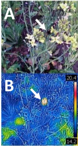
Aerial survey with rotary-wing drones equipped with an object-detection sensor or collision-prevention sensors can achieve a closer and targeted survey in apple orchards. An aerial survey at the KARI demonstrated that detection of plant diseases on individual apple trees would be possible using a rotary-wing drone. Two major apple diseases at the KARI were investigated by using a thermal camera, and the results of the survey showed that anthracnose on fruit was not detectable with a thermal sensor, but Marssonia blotch on leaves was readily detectable because infected leaves exhibited 2–3°C higher temperature than healthy leaves (Fig. 4). This might be caused by the fact that infected leaves generally reduce trans-piration and thus leaf temperature increases (Taiz and Zeiger, 2006). Thresholding (i.e., changing values of temperature threshold) for disease detection readily extracted infected leaves from healthy leaves (Fig. 4), suggesting that automatic detection using image analysis is possible. Such thermal imaging also can be used to detect flying insects. The idea is based on the fact that the body temperature of a flying insect increases due to the movement of flight muscles (Chapman, 1999). Therefore, it may not be able to detect when an insect is not using flight muscles but can detect when it is flying (Fig. 5).
Fig. 3. Detection of great plantain (Plantago asiatica L.), a dominant weed species on a pre-planting apple plot at the KARI. A, composite aerial imagery from 149 aerial images obtained with a rotary-wing drone; B, a close-up view of aerial imagery to detect P. asiatica; C, ground image of P. asiatica. White arrows indicate P. asiatica.
Remote sensing using drones has multiple advantages for apple IPM. The case study at the KARI suggests the possibility of site-specific or individual tree-level pest detection and mana-gement. Detecting changes in the tree canopy in the orchards over a period also can be achieved by repeated flights of drones. However, large-scale remote sensing could be challenging due to the limitations of battery life and flight regulation (e.g., visual line-of-sight rule).
Geographic Information System (GIS)
GIS is a geospatial technology for creating and managing spatial data and associated attributes (Park and Tollefson, 2005). GIS can integrate data collected in different times, at spatial scales, and with various sensors (Park et al., 2007). In the early stage of GIS development, the main method to create GIS data was digitizing, manually entering, and scanning spatial data or maps. However, recent GIS data can be commonly acquired with remote sensing by using satellites and drones, creating interactive queries, analyzing spatial information, and editing data (see Figs. 1–2 for an example).
A report by the National Geospatial Advisory Committee (NGAC, 2016) envisioned four emerging technologies in GIS. These include real‐time spatiotemporal data creation and inte-raction, miniaturization of technologies, the proliferation of
Fig. 5. Detection of flying insects using thermal imaging. A, RGB image and corresponding thermal image (B) of a flying bum-blebee (white arrow). The unit of the temperature on thermal images is degree Celsius.
Fig. 4. Detection of two major apple diseases (anthracnose on fruit and Marssonia blotch on leaves, white arrows) at the KARI by using thermal imaging to develop an automated disease detection tool. Note that anthracnose on fruit is not detectable by changing temperature thresholds, but Marssonia blotch on leaves can be detectable. * Multi-Spectral Dynamic Imaging adds visible light details to thermal images, embedding edge and outline detail onto thermal readings.
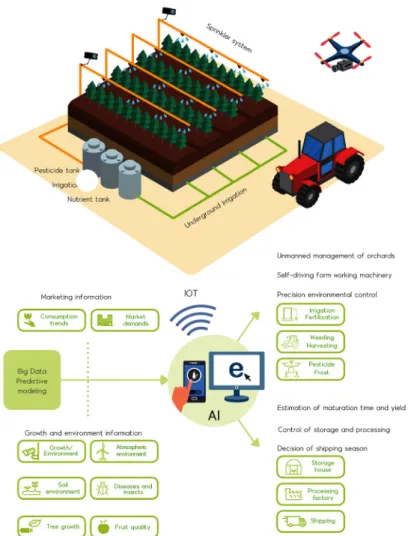
new mobile geospatial sensor platforms, expanding wireless and web networks, and advances in computing speed and capacity for geospatial research and applications. Based on the current trend of information technology, data analytics and mobility of GIS continue to grow and thus, the future GIS may include virtual reality, 3D GIS, mobile GIS, and Internet of Things (IoT). A good example would be current research efforts at the KARI on establishing a smart farming system in apple orchards using IoT and big-data-driven models (Fig. 6).
Artificial Intelligence
Since artificial intelligence (AI) was founded in 1955, AI development has been focused on reasoning, planning, learning, natural language processing, perception, and manipulating
objects (Russell and Norvig, 2020). Among them, machine learning (ML) uses computer algorithms to improve automated self-learning by using training and validation data (Wang et al., 2019). There are three main approaches in ML: supervised, unsupervised, and reinforcement learning. In supervised learning, the computer learns a general rule that maps inputs to outputs with training data and labeling or annotation (e.g., detecting target pest) (Hastie et al., 2009). No labels are given to the learning algorithm in unsupervised learning, but the computer finds the structure or pattern by itself (i.e., distinguishing crop damage by multiple pests). Therefore, unsupervised learning is generally used to discover hidden patterns or features in data (Russell and Norvig, 2020). Reinforcement learning makes computer programs interact with a dynamic or changing envi-ronment (e.g., pest outbreaks in various envienvi-ronments). In
Fig. 6. The KARI model for establishing a smart farming system in apple orchards. The model includes automation of apple production, unmanned pest forecasting and monitoring system, and improvement of pest identification algorithm.
addition, the deep learning technique mimics the human brain in processing unstructured and unlabeled data. Using deep learning, automated detection of insect pests (Roosjen et al., 2020; Rustia et al., 2021), plant diseases (Hasan et al., 2020), and weeds (Wang et al., 2019) could be achieved. However, there have been no studies published on the use of deep learning for apple IPM pest detection yet.
Application of Control Measures using
Aerospace Technology
Chemical Control
Airplanes have long been used to apply pesticides in large areas since the first airplane was invented. The prolific use of a manned airplane to apply pesticides after World War II is still the main tool for large-scale pesticide application in production agriculture and forestry (Felsot et al., 2010; Heidary et al., 2014). Recently, rotary-wing drones have drawn attention for pesticide and fertilizer applications (Mogili and Deepak, 2018), which opened up an opportunity for aerial site-specific chemical control. In general, a decision for pesticide application is based on the economic threshold; when the average pest density is above the economic threshold, a pesticide is applied in the entire field. In contrast, site-specific pest management determines the location of pest control within a field than uniform pest control the field (Park et al., 2007). One of the major advantages of site-specific pest management is the ability to reduce insec-ticide use because applications are made only to a part of the
field only where pest control is needed. With rotary-wing drones, site-specific application of pesticides can be realized in apple orchards.
Biological Control
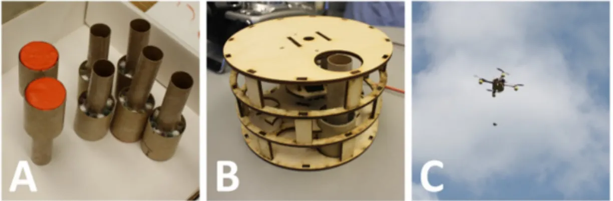
Since the use of aircraft to release natural enemies was first suggested by Herren et al. (1987) several aerial-release systems using manned aircraft have been developed (Rosenthal, 2017; Carroll et al., 2008). Park et al. (2018) developed drones equipped with an aerial system for the precision release of natural-enemy insects to control invasive plants. The aerial- release system comprises a pod carrying biocontrol agents and a dispenser that releases each pod while in the sky (Fig. 7). A recent improvement of the system included a 3D-printed pod made of environmentally-friendly materials such as polyvinyl alcohol (Kim et al., 2021). Recent advances in drone technology have created new opportunities to reduce application costs and increase coverage of areas compared to manual distribution (Filho et al., 2020). Research on the aerial release of predatory mites to control spider mites has been attempted, but more research needs to be done for apple IPM.
Conclusion
Aerospace and geospatial technologies together have already been transforming agriculture. Such technologies could be used to accurately detect and monitor pests, make management decisions, and apply control measures for apple IPM.
Minia-Fig. 7. An example aerial system for releasing natural-enemy insects using drones for biological control. Natural enemy insects are loaded into the pod (A), and then the pods are loaded to a dispenser (B). The dispenser is attached to a rotary-wing drone and a pod is deployed aerially (C). After the release of the pods from the sky, the clay cap is broken upon ground impact and the natural-enemy insects escape the pods. Detailed description and operation of the system can be found in Park et al. (2018).
turization and high accuracy of GPS, along with desktop and web GIS, have already revolutionized the ability to understand the spatial patterns of pest populations, which enables site- specific pest management to increase control efficiency with reduced pesticide input for apple IPM. Remote sensing of pests has become a common tool and GIS technology has become more affordable, which could be incorporated into apple IPM. Further development of such technology will be empowered by AI and IoT for automation of pest detection and decision making for apple IPM (Fig. 6).
Acknowledgment
This article is dedicated to the Late Dr. Soon-Won Lee (1959–2018) who educated apple growers and inspired many fellow researchers for 18 years as Senior Research Entomologist and Director of the Korea Apple Research Institute. This research was partly supported by the Brain Pool Program of the National Research Foundation of Korea (2018H1D3A2001526) and by the Cooperative Research Program for Agriculture Science and Technology Development (Project No. PJ01368701) of Rural Development Administration, Republic of Korea.
Statements for Authorship Position &
contribution
Park, Y.-L.: West Virginia University, Morgantown, WV, USA, Professor; Designed the research, con-ducted field reserch, analyzed data, and wrote the manuscript
Cho, J.R.: Rural Development Administration, Researcher; Conducted field experiments
Choi, K.-H.: Rural Development Administration, Researcher; Conducted field experiments
Kim, H.R.: Rural Development Administration, Researcher; Conducted field experiments
Kim, J.W.: Gyeongsangbukdo Agricultural Research & Extension Services, Researcher; Conducted field experiments
Kim, S.J.: Rural Development Administration, Researcher; Conducted field experiments
Lee, D.-H.: Apple Research Institute, Researcher; Conducted
field experiments
Park, C.-G.: Korea National College of Agriculture and Fisheries, Professor; Conducted field experiments Cho, Y.S.: Apple Research Institute, Researcher; Edited the
manuscript
All existing authors read and approved the manuscript.
Literature Cited
Bauer, M.E., 1985. Spectral inputs to crop identification and condition assessment. Proc. IEEE, 73, 1071-1085.
Brewster, C.C., Allen, J.C., Kopp, D.D., 1999. IPM from space: Using satellite imagery to construct regional crop maps for studying crop-insect interaction. Am. Entomol., 45, 105-17. Carroll, M.W., Glaser, J.A., Hellmich, R.L., Hunt, T.E., Sappington,
T.W., Calvin, D., Copenhaver, K., Fridgen, J., 2008. Use of spectral vegetation indices derived from airborne hyperspectral imagery for detection of European corn borer infestation in Iowa corn plots. J. Econ. Entomol., 101, 1614-1623.
Chapman, R.F., 1999. The Insects: structure and function, 4th edition. Cambridge University Press, Cambridge.
Clevers, J.G.P.W., 1999. The use of imaging spectrometry for agricultural applications. ISPRS J. Photogramm., 54, 299-304. Curran, P.J., 1985. Aerial photography for the assessment of crop
condition: a review. Appl. Geogr., 5, 347-360.
Felsot, A.S., Unsworth, J.B., Linders, J.B., Roberts, G., Rautman, D., Harris, C., Carazo, E., 2010. Agrochemical spray drift; assess-ment and mitigation - A review. J. Environ. Sci. Health Part B, 46, 1-23.
Filho, F.H., Heldens, W.B., Kong, Z., de Lange, E.S., 2020. Drones: Innovative technology for use in precision pest mana-gement. J. Econ. Entomol., 113, 1-25.
Fitzgerald, G.J., Maas, S.J., Detar, W.R., 2004. Spider mite detection and canopy component mapping in cotton using hyperspectral imagery and spectral mixture analysis. Prec. Agric., 5, 275-289.
Hasan, R.I., Yusuf, S.M., Alzubaidi, L., 2020. Review of the state of the art of deep learning for plant diseases: a broad analysis and discussion. Plants, 9, 1302.
Hastie, T., Tibshirani, R., Friedman, J., 2009. Overview of supervised learning, in: Hastie, T., Tibshirani, R., Friedman, J. (Eds), The elements of statistical learning, Springer, New York, pp. 9-41. Heidary, M., Douzals, J.P., Sinfort, C., Vallet, A., 2014. Influence
of spray characteristics on potential spray drift of field crop sprayers: a literature review. Crop Prot., 63, 120-130.
Herren, H.R., Bird, T.J., Nadel, D.J., 1987. Technology for auto-mated aerial release of natural enemies of the cassava mealybug
and cassava green mite. Int. J. Trop. Insect Sci., 8, 883-885. Jensen, R.R., 1983. Biophysical remote sensing. Ann. Assoc. Am.
Geogr., 73, 111-132.
Kim, J., Huebner, C., Reardon, R., Park, Y.-L., 2021. Spatially- targeted biological control of mile-a-minute weed using Rhino-ncomimus latipes (Coleoptera: Curculionidae) and an unmanned aircraft system. J. Econ. Entomol., in press.
Mogili, U.R., Deepak, B.B.V.L., 2018. Review on application of drone systems in precision agriculture. Proc. Comp. Sci., 133, 502-509.
Moran, M.S., Inoue, Y., Barnes, E.M., 1997. Opportunities and limitations for image-based remote sensing in precision crop management. Remote Sens. Environ., 61, 319-346.
NGAC, 2016. Emerging technologies and the geospatial landscape. National Geospatial Advisory Committee, U.S. Department of Interior, Washington, D.C..
Park, Y.-L., Gururajan, S. Thistle, H., Chandran, R., Reardon, R., 2018. Aerial release of Rhinoncomimus latipes (Coleoptera: Curcul-ionidae) to control Persicaria perfoliata (Polygonaceae) using an unmanned aerial system. Pest Manag. Sci., 74, 141-148. Park, Y.-L., Krell, R.K., Carroll, M., 2007. Theory, technology, and
practice of site-specific insect pest management. J. Asia-Pac. Entomol., 10, 89-101.
Park, Y.-L., Tollefson, J.J., 2005. Spatial prediction of corn rootworm (Coleoptera: Chrysomelidae) adult emergence in Iowa cornfields. J. Econ. Entomol., 98, 121-128.
Roosjen, P.P., Kellenberger, B., Kooistra, L., Green, D.R.,
Fahren-trapp, J., 2020. Deep learning for automated detection of Drosophila suzukii: potential for UAV‐based monitoring. Pest Manag. Sci., 76, 2994-3002.
Rosenthal, G., 2017. PPQ explores the tantalizing promise of unmanned air- craft systems. USDA APHIS. from https://www. aphis.usda.gov/aphis/ourfocus/planthealth/ppq-program-over view/plant-protection-today/articles/unmanned-aircraft-syste ms (accessed on 15 February, 2020).
Russell, S., Norvig, P., 2020. Artificial Intelligence: A Modern Approach, 4th edition. Pearson, London.
Rustia, D.J.A., Chao, J.J., Chiu, L.Y., Wu, Y.F., Chung, J.Y., Hsu, J.C., Lin, T.T., 2021. Automatic greenhouse insect pest detection and recognition based on a cascaded deep learning classification method. J. Appl. Entomol., in press.
Taiz, L., Zeiger, E., 2006. Plant physiology, 4th edition. Sinauer Associates, Inc., Sunderland, MA.
Wang, A., Zhang, W., Wei, X., 2019. A review on weed detection using ground-based machine vision and image processing techniques. Comp. Electron. Agric., 158, 226-240.
Yang, Z., Rao, M.N., Elliott, N.C., Kindler, S.D., Popham, T.W., 2005. Using ground-based multispectral radiometry to detect stress in wheat caused by greenbug (Homoptera: Aphididae) infestation. Comp. Electron. Agric., 47, 121-135.
Zhang, J., Huang, Y., Pu, R., Gonzalez-Moreno, P., Yuan, L., Wu, K., Huang, W., 2019. Monitoring plant diseases and pests through remote sensing technology: a review. Comp. Electron. Agric., 165, 104943.