지하공간통합지도 품질관리 개선방안 연구
관로형 지하시설물을 중심으로
-Research on Improving Quality Management for Underground Space Integration Map
Focusing on pipetype underground facilities
-배상근* · 김상민** · 유은진***
Bae, Sang-Keun · Kim, Sang-Min · Yoo, Eun-Jin
Abstract
The development and utilization of underground spaces are increasing as the use of land based on ground surface became limited due to rapid urbanization triggered by population growth and industrialization. Despite its merit of efficient use of limited land and space, it may contribute to occurrence of various disasters such as sinkholes and damage to underground facilities. After the sinkholes formed and occurred across the country in 2014, there has been an effort to establish Underground Space Integration Map containing 15 types of underground information. Still, there is an increasing demand to improve the quality of underground information stemmed from continuation of such events including the rupture of the hot water pipe in Goyang-si and the fire in the KT site in Ahyeon-dong, Seoul. Hereby, with the aim to improve the quality of Underground Space Integration Map, this study analyzes quality standards, regulations, and guidelines related to spatial data to improve quality inspection standards and methods included in the production rules for the Underground Space Integration Map. In particular, it suggests improvement plan for data quality management for pipe-type underground facilities, known as lifelines, which are essential part of daily life of the citizens, and the largest cause for accidents according to 15 types of underground information managed through the Underground Space Integration Map.
Keywords: Underground space integration map, Underground information, Quality management, Underground facilities, Lifeline
1. 서 론
인구증가 및 산업화에 따른 급속한 도시화로 인해 지표 중심의 토지이용에 한계가 나타남에 따라 지하 공간에 대한 개발과 활용이 점차 증가하고 있다(배상 근 외 2017). 특히 서울시의 경우 서울 삼성동 영동대 로 지하공간 복합개발 사업을 비롯해 용산역 전면 공 원 지하공간 개발사업, 서울시청과 광화문 일대를 잇* 한국국토정보공사 공간정보연구원 책임연구원 LX Spatial Information Research Institute (first author: [email protected]) ** 한국국토정보공사 공간정보연구원 선임연구원 LX Spatial Information Research Institute ([email protected])
는 강북 지하도시 개발사업 등 지하공간을 효율적으 로 활용하기 위한 여러 사업들을 추진 중이다(배상근 외 2020a). 이러한 현상은 한정된 국토공간을 효율적 으로 활용한다는 측면에서 큰 장점을 가지는 동시에 이로 인해 싱크홀 및 지반침하, 지하시설물 파손과 같 은 재난재해가 발생할 수 있다는 문제점을 지닌다. 지하공간 안전확보를 위한 초기 정부 차원에서의 노력으로는 아현동 가스 폭발사고와 대구 가스 폭발 사고 등 지하시설물로부터 발생한 인명피해 방지차원 에서 수행된 지하시설물 전산화 사업을 꼽을 수 있다. 지하시설물 전산화 사업은 1998년부터 2010년까지 시지역을 대상으로 사업을 수행하였고, 2011년부터 는 군지역까지 사업의 범위를 확대하여 현재까지 지 하공간의 시설물에 대한 위치정보를 구축하고 있다. 지하시설물 전산화 사업과 관련이 있는 법률인 도 로법 제62조(도로점용에 따른 안전관리 등) 제2항 및 제3항에 따르면 주요 지하 매설물을 설치하여 공사를 마친 경우에는 그 준공도면을 도로 관리청에 제출하 여야 하고, 동법 시행령 제59조(주요지하매설물)에 의 해 지하매설물의 대상을 가스공급시설, 송유관, 광역 상수도, 지방상수도 및 공업용수도 중 관로시설, 송전 시설, 전기통신관에 수용되는 전송·선로설비, 가스 배 관, 도시철도 중 지하 부분 등으로 구분하였다. 지하시설물 전산화 사업 이후에도 2014년도에 전 국적으로 발생한 싱크홀로 인해 ‘지하공간’과 관련된 인터넷 검색어로 싱크홀, 지하수, 하수구, 지하공간 침 수 등이 등장하였다(최해옥·백성준 2016). 이에 정부 차원에서의 예방대책을 마련하기 시작하면서 2015년 부터 15종의 지하정보를 통합한 지하공간통합지도가 구축되고 있으며, 2016년에는 「지하안전관리에 관한 특별법」을 제정하고 2018년부터 시행함으로써, 지하 공간을 효과적으로 개발하고 안전하게 관리하기 위해 노력하고 있다. 그러나 이러한 노력에도 불구하고, 고양시 온수관 파열, 서울 아현동 통신구 화재, 서울 상도동 및 경기 도 구리시 지반침하 등 여전히 지하공간에서의 안전 사고가 지속됨에 따라 지하정보의 품질향상에 대한 요구가 증대되고 있다(배상근 외 2020b). 이에 본 논문에서는 지하공간통합지도의 품질 향상 을 위해 2018년도에 국토교통부에서 고시한 「지하공 간통합지도 제작 작업규정」에 명시된 품질검사 기준 및 방법을 개선하기 위한 방안을 마련하고자 하였다. 특히 지하공간통합지도를 통해 관리되는 15종의 지하 정보 중 사고 발생의 가장 큰 원인이자, 국민들의 일상 생활에 반드시 필요해 라이프 라인(life line)*이라고 도 불리는 관로형 지하시설물을 대상으로 데이터 품 질관리를 위한 개선방안을 제시하였다.
2. 공간데이터 품질 기준 검토
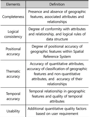
데이터 품질은 “데이터를 활용하는 사용자의 다양 한 활용 목적이나 만족도를 지속적으로 충족시킬 수 있는 수준”으로 정의된다(Larry P. English 1999). 그 러므로 데이터 품질관리(DQM: Data Quality Mana-gement)는 데이터의 품질을 지속적으로 유지하고 개 선함으로써 사용자의 만족도를 높이기 위해 수행하는 일련의 활동으로 정의할 수 있다. 공간데이터는 공간데이터 뿐만 아니라 공간정보와 무관하였던 다른 분야 정보와의 융·복합을 위한 기반 이 되는 자료로써 주목받고 있다(최재연·김은형 2020). 이처럼 데이터의 연계와 개방이 활성화 되면서 데이 터 품질에 관한 문제가 발생하게 되었고, 데이터의 신 뢰도가 중요한 요소로 인식되었다. 따라서 데이터 신 뢰도 향상을 위해 국가적 차원에서도 관련 법률 및 규 * 네이버 국어사전, 인간 활동의 기본 공간인 도시의 기능에 근간이 되는 통신, 전력, 에너지, 상하수도, 운송 및 교통망 등 선 형태로 네트워크를 구성하는 사회 기반 시설을 통틀어 이르는 말정 제정, 데이터 표준화 작업 등의 노력을 지속하고 있다. 지하공간은 지상공간과 대칭을 이루는 개념으로서 상업적 또는 공공적 목적을 위하여 자연상태의 지표 면 아래 인위적으로 형성된 공간자원을 말한다(이인 수·고정석 2008). 그러므로 지하공간통합지도는 지하 공간상의 인공적, 자연적인 객체에 대한 위치정보와 공간적 인지를 위한 정보를 포함하는 공간데이터로 정의될 수 있다. 지하공간통합지도의 품질검사 기준 과 방법이 작업규정으로 제정되었으나, 품질관리 평 가기준과 방법에 대한 정의와 설명이 불명확하거나 구체적이지 못한 항목이 존재하며, 대부분 육안으로 검수를 진행하고 있다. 따라서 현재의 작업규정을 면 밀히 검토하고, 이에 따른 개선방안을 제시함으로써 데이터의 신뢰도를 향상시키는 것이 필요하다. 개선방안을 도출하기 위해서 우선적으로 검토해야 하는 표준은 공간데이터 품질관리를 위한 대표적인 국제 표준인 ISO 19157 이다. 이 표준은 공간데이터 품질 개념, 품질 평가 요소, 방법, 결과 도출 등 공간데 이터 품질관리 프로세스 전반에 관한 표준화된 방식 을 규정한다. 국내외 대다수의 공간데이터 품질관리 기준은 이 표준을 기반으로 하여 제작되었다. 이 표준 에서 데이터를 평가하는 품질요소는 완전성, 논리적 일관성, 위치 정확성, 시간 정확성, 주제 정확성, 유용 성이며, 유용성 요소에서는 다른 품질요소에서 설명 할 수 없는 사용자의 요구사항을 기반에 둔 추가적인 정량적 품질 구성요소를 추가 할 수 있다. 각 품질요소 에 대한 정의는 Table 1과 같다. 지하공간통합지도 품질기준의 개선을 위해 검토할 수 있는 국내의 대표적인 공간데이터 품질관리 규정 으로는 국토지리정보원의 「3차원 국토공간정보구축 작업규정」, 국토교통부 「국가공간정보센터 운영 세부 규정」과 「실내공간정보 구축 작업규정」 등에 포함된 품질기준이 있다. 이러한 품질기준은 ISO 19157의 기 본 개념을 이용하여 제정되었으며, 각 요소의 세부 평 가 항목 및 방법은 평가하는 데이터의 특성에 적합하 도록 변경하여 이용하고 있다. 이 중 본 논문에서는 지 하공간통합지도 데이터와 유사한 데이터 특성을 가지 는 3차원 국토공간정보구축 작업규정과 지하공간통 합지도 제작 작업규정, ISO 19157을 Table 2와 같이 비교‧분석하였다. 지하공간통합지도는 3차원의 공간 데이터로 구축되기 때문에 기본적으로 3차원 국토공 간정보와 유사한 품질관리 요소를 가진다. 3차원 데이 터에 대한 품질평가는 데이터 구조 및 위치/인접 정확 성과 관련된 위상 일관성과 위치정확성에서 수행한 다. 그러나 3차원 국토공간정보와는 달리 지하공간통 합지도에서는 영상데이터를 취급하지 않으므로 그리 드 데이터에 대한 정확성은 고려 대상에서 제외하고 있다. 데이터 관리 파일인 메타데이터와 성과품에 관 한 품질요소를 기타 품질요소로 추가하였다. Elements Definition Completeness
Presence and absence of geographic features, associated attributes and
relationships Logical
consistency
Degree of conformity with attributes and relationship, and logical rules of
data structure Positional
accuracy
Degree of positional accuracy of geographic features within Spatial
Reference System
Thematic accuracy
Accuracy of quantitative attributes, accuracy of classification of geographic
features and non-quantitative attributes, and accuracy of their
relationships Temporal
accuracy
Temporal relationship in geographic features and quality of temporal
attributes
Usability Additional quantitative quality factors based on user requirement
Table 1. Data quality elements.
Quality Elements
Underground Space Integration Map 3D Land Geo-spatial Information ISO 19157 (Detailed)
Sub-Elements Sub-sub Elements Sub-Elements(Detailed) Sub-sub Elements Component Completenes
s Omission Target ObjectOmitted Omission
Target Area Omitted Commission Target Object Omitted Omission
Logical Consistency (Standard) Concept Consistency LOD (Visualization) Consistency Concept Consistency LOD Consistency Conceptual Consistency Visualization Consistency Topological Consistency 2D Data Consistency Topological Consistency 2D Data Consistency Topological Consistency 3D Data
Consistency Structure Consistency3D Data
- - - - Domain Consistency - - - - Format Consistency Positional Accuracy (Spatial) Absolute or External Accuracy Accuracy of Standard Coordinates Absolute or External Accuracy Accuracy of Standard Coordinates Absolute Accuracy (External) General measurement due to positional uncertainty 2D Positional
Accuracy 2D Positional Accuracy Vertical Position Uncertainty 3D Positional
Accuracy 3D Positional Accuracy Horizontal Position Uncertainty
Relative or Internal Accuracy Adjacency to Boundary of 2D Data Relative or Internal Accuracy Adjacency to Boundary of 2D Data
Relative or Internal Accuracy Adjacency to
Boundary of 3D Data
Adjacency to Boundary of 3D Data
- - Gridded data positional accuracy
Positional Accuracy of
3D Topological Data Gridded data positional accuracy
ThematicAccu racy (Attributes)
Classification
Accuracy Categorization Accuracy Classification Accuracy Categorization Accuracy Classification Correctness Logical
Accuracy Logical Accuracy
-Attribute Accuracy Attributes Mismatched Attribute Accuracy Attributes
Mismatched Quantitative Attributes Accuracy Attributes
Omission AttributesOmission Non-quantitative Attributes Correctness
Others
Errors in Writing Management
File
Metadata
Omission Management FileErrors in Writing Metadata Omission
Temporal Accuracy
Accuracy of a Time Measurement
Product Omitted Product Omission Product Omitted Product Omission ConsistencyTemporal Operating
Adequacy of product
Operating Adequacy of
product - - Time Validity
Table 2. Comparision of Data quality elements.
메타데이터는 데이터의 데이터로 정의되며, 하위레 벨 데이터에 대한 각종 정보(속성)를 설명하는 데이터 이다. 지하공간통합지도에서 메타데이터는 데이터의 좌표체계, 표현 단위 등 기본적인 정보를 제공하며, 품 질검사에 유용하게 사용될 수 있다. 구축된 지하공간 통합지도는 지하정보활용지원센터의 지하정보통합 관리시스템에 축적되고, 지하정보 활용시스템을 이용 해 지자체 및 유관기관 담당자가 업무에 활용하게 된 다. 따라서 제작된 지하공간통합지도는 통합관리시스 템에 탑재 시 성과품의 누락 여부와 시스템 탑재 적정 성을 검사한다. 그러나 ISO 19157에서 데이터의 품질 관리 요소 중 하나로 정의하고 있는 시간품질 관련 항 목은 별도로 검사하고 있지 않아 이를 추가해야 할 지 여부를 검토할 필요가 있다. 지하공간정보의 특성상 데이터의 활용 및 제공시 보안이 요구되는 데이터이기 때문에 데이터의 보안성 에 관한 품질관리가 필요하다. 그리고 지하에 매설되 어 쉽게 접근 및 확인이 어려운 데이터 특성상 데이터 의 생성·갱신·삭제에 대한 이력관리가 지속적으로 이 루어져야 할 것이다. 또한, 데이터를 육안으로 검수하는 방식은 작업의 일관성과 데이터 신뢰성 확보에 많은 어려움이 있으 므로 데이터를 자동으로 검수할 수 있는 방법에 대한 기준이 필요하다.
3. 지하공간통합지도 품질관리 현황 및
개선방안
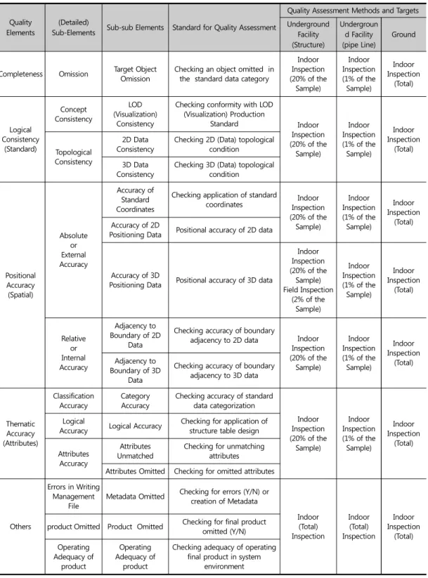
3.1. 지하공간통합지도 개요 「지하안전관리에 관한 특별법」은 지하공간의 안전 한 개발과 이용을 위해 체계적인 안전관리체계를 확 립하여 공공의 안전을 확보하는 것이 주된 목적으로 2018년 1월 1일 시행되었다. 「지하안전관리에 관한 특별법」 제42조 및 동법 시행령 제33조 제5항에서는 지하의 개발·이용·관리에 활용할 수 있도록 지하공간 통합지도를 제작하기 위해 필요한 사항을 규정하였 다. 지하공간통합지도는 「지하공간통합지도 제작 작 업규정」에 의해 구축되며, 관리기관별로 구축·관리되 고 있는 지하시설물, 지하구조물, 지반 등의 다양한 지 하정보를 효율적으로 관리·운용하기 위해 2015년부 터 매년 지하공간통합지도 구축 사업이 추진되고 있다. 지하공간통합지도는 「지하공간통합지도 제작 작업 규정」 제33조(품질관리) 제1항의 별표 16의 “지하공 간통합지도 품질검사 기준”에 의해 성과물의 품질검 사가 이루어지고 있으며 그 내용은 Table 3과 같다. 품 질검사 기준에서는 지하공간통합지도의 전체 데이터 항목을 검사하기 위한 품질요소, 세부요소, 세세부요 소, 품질검사 기준, 품질검사 방법 및 대상에 대해 정 의하고 있다. 구축된 데이터는 별표 17 내지 19의 “지하공간통합 지도 품질검사 방법”에 따라 품질요소별 품질검사를 실시하고, 품질검사 결과에 따라 별표 20의 “지하공간 통합지도 품질검사표”를 작성하여 제출하여야 한다. 3.2. 지하공간통합지도 품질검사 현황 및 문제점 지하공간통합지도의 품질검사 항목은 5개의 품질 요소와 11개의 세부요소, 16개의 세세부요소로 구분 되며, 각 세세부요소에 대한 품질 검사 방법에 의해 지 하공간통합지도 데이터의 품질검사를 진행한다. 품질 요소는 ‘완전성’, ‘논리일관성’, ‘위치정확성’, ‘주제정 확성’, ‘기타’로 구분되며 각각의 품질요소를 기준으로 세부요소와 세세부요소의 구성현황은 다음과 같다. 완전성은 대상객체의 누락여부를 확인하며, 논리일 관성은 지하시설물 세밀도 제작기준의 적용여부를 확 인하는 개념일관성과 3차원 정보의 위상조건을 확인 하는 위상일관성으로 구성된다. 위치정확성은 기준좌Quality Elements
(Detailed)
Sub-Elements Sub-sub Elements Standard for Quality Assessment
Quality Assessment Methods and Targets Underground Facility (Structure) Undergroun d Facility (pipe Line) Ground
Completeness Omission Target ObjectOmission Checking an object omitted in the standard data category
Indoor Inspection (20% of the Sample) Indoor Inspection (1% of the Sample) Indoor Inspection (Total) Logical Consistency (Standard) Concept Consistency LOD (Visualization) Consistency
Checking conformity with LOD (Visualization) Production Standard Indoor Inspection (20% of the Sample) Indoor Inspection (1% of the Sample) Indoor Inspection (Total) Topological Consistency 2D Data
Consistency Checking 2D (Data) topological condition 3D Data
Consistency Checking 3D (Data) topological condition
Positional Accuracy (Spatial) Absolute or External Accuracy Accuracy of Standard Coordinates
Checking application of standard
coordinates InspectionIndoor (20% of the Sample) Indoor Inspection (1% of the Sample) Indoor Inspection (Total) Accuracy of 2D
Positioning Data Positional accuracy of 2D data
Accuracy of 3D
Positioning Data Positional accuracy of 3D data
Indoor Inspection (20% of the Sample) Field Inspection (2% of the Sample) Indoor Inspection (1% of the Sample) Indoor Inspection (Total) Relative or Internal Accuracy Adjacency to Boundary of 2D Data
Checking accuracy of boundary
adjacency to 2D data Indoor Inspection (20% of the Sample) Indoor Inspection (1% of the Sample) Indoor Inspection (Total) Adjacency to Boundary of 3D Data
Checking accuracy of boundary adjacency to 3D data
Thematic Accuracy (Attributes)
Classification
Accuracy CategoryAccuracy Checking accuracy of standard data categorization
Indoor Inspection (20% of the Sample) Indoor Inspection (1% of the Sample) Indoor Inspection (Total) Logical
Accuracy Logical Accuracy Checking for application of structure table design
Attributes Accuracy
Attributes
Unmatched Checking for unmatching attributes Attributes Omitted Checking for omitted attributes
Others
Errors in Writing Management
File Metadata Omitted
Checking for errors (Y/N) or creation of Metadata Indoor (Total) Inspection Indoor (Total) Inspection Indoor Inspection (Total) product Omitted Product Omitted Checking for final product omitted (Y/N)
Operating Adequacy of product Operating Adequacy of product
Checking adequacy of operating final product in system
environment
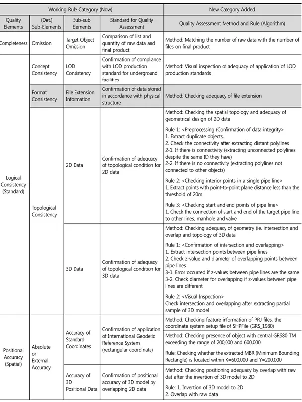
표계와 2차원 및 3차원 위치정보의 정확성을 확인하 는 절대적 또는 외적정확성과 2차원 및 3차원 정보의 경계인접 여부를 확인하는 상대적 또는 내적 정확성 으로 구성된다. 주제정확성은 최종성과와 표준데이터 항목 일치 여 부를 확인하는 분류정확성, 최종성과의 테이블 설계 서 적용 여부를 확인하는 논리정확성, 원시자료와 최 종성과의 속성 일치여부 및 누락을 확인하는 속성 정 확성으로 구성된다. 기타 항목은 메타데이터의 누락 을 확인하는 관리파일 작성오류, 성과품 누락 여부 확 인, 운영서버 탑재를 통한 성과 탑재 적정성 등으로 구 성된다. 지하공간통합지도 품질검사 방법과 개선사항을 파 악하기 위해 업무 담당자 인터뷰를 실시한 결과, 데이 터 수집 및 구축 후 진행되는 품질검사 과정에서 현행 기준과 방법을 이용하고 있는 것을 알 수 있었다. 그러 나 현행 기준이 구체적이지 못한 항목들로 인해 실제 적용이 어렵거나, 작업자별로 기준을 다르게 해석하 여 상이한 방식으로 작업을 진행할 가능성이 존재하 였다. 또한 속성값의 누락이나 유효성과 같은 항목 외 에 대다수의 항목을 육안으로 검수하고 있으며, 특히 도형정보에 대한 사항은 도형의 중복 외에는 모두 육 안검수를 실시하고 있다. 이러한 육안검수 방식은 시 간과 인력 소모 측면에서 비효율적이며, 통일되지 못 한 작업방식으로 인해 성과물의 일관성과 신뢰성이 떨어질 수 있다. 실제로 3차원 지하시설물의 모델링의 경우 관로 자체 심도값 이상치, 관로 간 이격 발생, 최 종결과물인 시설물과 DEM 불일치 등 다양한 유형의 문제가 발생하고 있음을 확인하였다. 위에서 설명한 현재 지하공간통합지도의 공간 및 속성정보 품질검사 방법은 품질 검사공정에 있어 자 동화된 방법이 아닌 육안검수에 의존함에 따라 데이 터의 품질을 담보하기 어렵고, 일관된 검수가 어렵다 는 단점이 있다. 따라서 단시간 내에 고품질의 성과를 얻기 위한 자동검수 방식으로의 품질검사 프로세스 전환이 필요하다. 지하공간통합지도를 통해 구축되고 있는 3차원 지 하시설물 데이터는 2차원 데이터의 변환을 통해 생성 된다. 따라서 고품질의 3차원 데이터를 얻기 위해서는 2차원 원시데이터의 품질확보가 선행되어야 한다. 이 를 위해 2차원 데이터의 도형과 속성, 위상정보의 적 정성을 확보한 후 3차원 데이터로의 변환이 이루어지 는 것이 바람직할 것이다. 또한 3차원 데이터 변환과 정에서 발생할 수 있는 오류를 방지하기 위해 3차원 데이터를 2차원 데이터로 역변환 한 후, 2차원 원시데 이터와 중첩하여 품질검사를 실시하여야 한다. 3.3. 지하공간통합지도 품질검사 개선 방안 현재 지하공간통합지도에서 제공하는 다양한 지하 시설물 정보의 정확성 및 신뢰성을 향상시키기 위한 품질검사 방식의 개선이 필요한 상황이다. 이에 따라 본 논문에서는 3.2절에서 언급한 현행 지하공간통합 지도 품질검사 기준 및 방법을 개선하기 위한 방안을 제시하고자 하였다. 기존에 비해 데이터 품질의 일관 성과 신뢰성을 향상시키는 것이 논문의 목적이므로 데이터의 자동검수를 위해 현재의 품질검사 기준을 Table 4와 같이 구체화하였다. 현재 품질요소, 세부요소, 세세부요소, 품질검사 기 준으로 구성된 4가지 검사항목에 품질검사 방법, 품질 검사 규칙, Flow Diagram의 3가지 항목을 추가하 였다. 품질검사 방법 항목은 품질검사 기준 항목을 바탕 으로 데이터 검수 시 확인해야 하는 사항을 좀 더 구체 적으로 정의하며, 품질검사 규칙 항목은 소프트웨어 기반의 자동검수에 필요한 사항을 정리하였다. 특히 품질검사 규칙 항목의 경우 속성정보 뿐 아니라 도형 정보까지 소프트웨어로 검수하기 위해 공간데이터의 기하학적 구조와 위상관계를 정의한 기존 자료들을 분석하여, 도형정보의 위상일관성, 위치정확성 등을
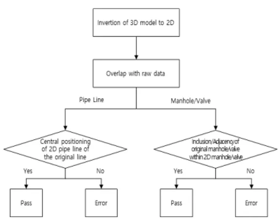
검수하기 위한 세부적인 규칙과 알고리즘 등을 제시 하였다. 위상일관성 요소는 도형의 중복, 교차 및 중첩 등을 검수하여 2차원 및 3차원 데이터의 공간적 위상 과 기하구조 적정성을 확인할 수 있도록 하고, 위치정 확성 요소는 좌표계 준수 여부, 3차원 데이터와 2차원 데이터의 중첩, 심도 적용 우선순위의 적정성, 객체 간 인접 적합성 등을 검수하여 데이터의 절대적·상대적 위치정확도를 확인할 수 있도록 하였다. Flow Diagram은 품질검사 규칙에서 규정하고 있 는 내용을 작업 흐름에 따라 순서도의 형태로 나타낸 것이다. 특히 특정 요소에 대한 품질검사가 여러 단계 를 거쳐 진행되는 경우 검사에 필요한 기준과 절차를 쉽게 파악할 수 있어, 품질검사 소프트웨어 개발 시 유 용하게 활용될 수 있을 것이다. 지면 한계 상 Flow Diagram을 Table 4에 포함하는 것이 어려워 Figure 1 과 Figure 2에 대표적인 Flow Diagram을 정리하였다. Figure 1은 2차원 정보 경계인접성을 검수하는 과 정을 나타내며, 그 절차는 다음과 같다. ① 경계인접성 검수를 위해 맨홀/밸브와 관로간 접 합여부 확인 ② 맨홀/밸브가 관로와 접합되어 있지 않은 경우, 맨홀/밸브와 주변관로 간 평면(2차원) 거리 계산 ③ 거리가 임계값 이내일 경우, 통과 ④ 거리가 임계값 이상일 경우, 오류 Figure 2는 3차원 위치정확성을 검수하는 과정을 나타내며, 그 절차는 다음과 같다. ① 모델링된 3차원 데이터를 평면 투영시킨 후 2차 원 데이터로 변환 ② 변환된 2차원 데이터와 원시데이터를 중첩하여 검수 ③ 대상 객체 유형 구분(관로, 맨홀 또는 밸브) ④ 관로일 경우, 평면 투영된 3차원의 관로(평면)의 중앙에 원시데이터의 관로(선)가 위치하면 통과 ⑤ 관로일 경우, 평면 투영된 3차원의 관로(평면)의 중앙에 원시데이터의 관로(선)가 위치하지 않으 면 오류 ⑥ 맨홀 또는 밸브의 경우, 평면 투영된 3차원 맨홀/ 밸브(평면)내에 원시데이터의 맨홀/밸브(점)가 위치하면 품질 검사 완료 ⑦ 맨홀 또는 밸브의 경우, 평면 투영된 3차원 맨홀/ 밸브(평면)내에 원시데이터의 맨홀/밸브(점)가 위치하지 않으면 오류 판정 데이터는 구축하는 것도 중요하지만 이를 지속적으 로 현행화하여 최신성을 유지하는 것이 매우 중요하 다. 지속적으로 관리하지 않는 데이터는 현실과 괴리 가 생기게 되고, 현실과 다른 데이터는 그 가치가 낮아
Figure 1. Flow Diagram of Adjacency to Boundary of 2D Data
Figure 2. Flow Diagram of Positional accuracy of 3D data
Working Rule Category (Now) New Category Added Quality
Elements Sub-Elements(Det.) ElementsSub-sub Standard for Quality Assessment Quality Assessment Method and Rule (Algorithm)
Completeness Omission Target ObjectOmission Comparison of list and quantity of raw data and final product
Method: Matching the number of raw data with the number of files on final product
Logical Consistency
(Standard)
Concept
Consistency LODConsistency
Confirmation of compliance with LOD production standard for underground facilities
Method: Visual inspection of adequacy of application of LOD production standards
Format
Consistency File Extension Information
Confirmation of data stored in accordance with physical
structure Method: Checking adequacy of file extension
Topological Consistency
2D Data Confirmation of adequacy of topological condition for 2D data
Method: Checking the spatial topology and adequacy of geometrical design of 2D data
Rule 1: <Preprocessing (Confirmation of data integrity> 1. Extract duplicate objects,
2. Check the connectivity after extracting distant polylines 2-1. If there is connectivity (extracting unconnected polylines despite the same ID they have)
2-2. If there is no connectivity (extracting polylines not connected to other objects)
Rule 2: <Checking interior points in a single pipe line> 1. Extract points with point-to-point plane distance less than the threshold of 20m
Rule 3: <Checking start and end points of pipe line> 1. Check the connection of start and end of the target pipe line to other lines, manhole and valve
3D Data Confirmation of adequacy of topological condition for 3D data
Method: Checking adequacy of geometry (ie. intersection and overlap and topology of 3D data
Rule 1: <Confirmation of intersection and overlapping> 1. Extract intersection points between pipe lines
2. Check z-value and diameter of overlapping points between pipe lines
3-1. Error occurred if z-values between pipe lines are the same 3-2. Check diameter for overlapping if z-values between pipe lines are different
Rule 2: <Visual Inspection>
Check intersection and overlapping after extracting partial sample of 3D model Positional Accuracy (Spatial) Absolute or External Accuracy Accuracy of Standard Coordinates Confirmation of application of International Geodetic Reference System (rectangular coordinate)
Method: Checking feature information of PRJ files, the coordinate system setup file of SHPFile (GRS_1980) Method: Checking presence of object with central GRS80 TM exceeding the range of 200,000 and 600,000
Rule: Checking whether the extracted MBR (Minimum Bounding Rectangle) is located within X=600,000 and Y=200,000
Accuracy of 3D Positional Data Confirmation of positional accuracy of 3D model by overlapping 2D data
Method: Checking positioning adequacy by overlap with raw dat after the invertion of 3D model to 2D
Rule: 1. Invertion of 3D model to 2D 2. Overlap with raw data
Table 4. Suggests on Standard for Quality Assessment and improvement plan for pipe-type underground facilities
Working Rule Category (Now) New Category Added Quality
Elements Sub-Elements(Det.) ElementsSub-sub Standard for Quality Assessment Quality Assessment Method and Rule (Algorithm) 3-1 pipe line: checking central positioning of pipe line (polygon) inversed from pipe line (polyline) of raw data
3-2. Manhole and valve: checking inclusion or adjacency of manhole and valve (point) in raw data to inversed manhole and valve (polygon)
Adequacy confirmation reflecting rules Applicable to depth of pipe lines
Method: Checking the adequacy of applying the priority of depth of pipe lines (point, pipe lines (adjacent/average)) Rule: 1. Checking the presence of points within point-to-point distance of 20cm
2-1. Checking whether the depth values of two points match if points exist
2-1-1. Matching value: Pass
2-1-2. Unmatching value: Error (confirmation of raw data required)
※ It is not an error if two points in raw data have depth values while it is an error if only one has the value
2-2. Checking whether a point shares two lines in case of no point indicated
2-2-1. If yes, check reflection of average depth value of pipe line of two lines as depth value
2-2-1-1. use of average value: Pass 2-2-1-2. No reflection of average value: Error
2-2-2. If not, check reflection of the depth of appropriate line as depth value
2-2-2-1. Reflection of depth value: Pass 2-2-2-2. No reflection of depth value: Error
Confirmation reflecting rules applicable to depth of manhole and valve
Method: Checking the adequacy of applying the priority of depth of manhole and valve
Rule: 1. Checking the presence of point within the manhole or valve radius of 20cm
2-1. If yes, check depth attributes of pipe line with the point 2-1-1. When the depth attribute is a depth, pipe line (adjacent) depth: depth value +(pipe diameter) + (extra depth) 2-1-2. When the depth attribute is average depth: : Depth value + (Extra depth)
※ Values in bracket (pipe diameter, extra depth) are only applicable to manhole
2-2. No point: Average depth applied
Relative or Internal Accuracy Adjacency to Boundary of 2D Data Confirmation of consistent adjacency and separation between 2D pipe lines, pipe line and manhole, and pipe line and valve
Method: Checking presence of manhole and valve (points) distant from pipe line (between pipe line and manhole/valve) Rule: 1. Checking for intersection of valves and manholes (points) and pipelines (polylines)
2. It is an error if the shortest distance between valve/manhole and pipe line is greater than threshold of 20cm
Adjacency to Boundary of 3D Data
Confirmation of consistent adjacency and spacing between 3D pipe lines, pipe line and manhole, and pipe line and valve
Method: Checking the presence of manholes and valves distant from the pipeline
Rule: <Visual Inspection> Checking the gap (or distance) in partial samples extracted from 3D model
Working Rule Category (Now) New Category Added Quality
Elements Sub-Elements(Det.) ElementsSub-sub Standard for Quality Assessment Quality Assessment Method and Rule (Algorithm)
Thematic Accuracy (Attributes)
Classification
Accuracy CategorizationAccuracy
Confirmation of conformity and compliance between standard data item and final product
Method: Checking whether the categories of final product are matched with those of standard data
Confirmation of application of final product to table design
Method: Checking whether the final product attribute table is matched with table definition indicated in the rule
Attributes Accuracy
Attributes mismatch
Confirmation of matching attributes between raw data (shp) and final product
Method: Checking whether attribute field, number, and value of raw data are matched with those of final product
Attributes Omission Confirmation of key information including attribute information omitted -Attribute Value Validated Confirmation of logical validity of value of attributes in domain
Method: Checking validity of attributes value format, structure, and range
Temporal Accuracy (Log)
Time Missing Time Information Omission
Confirmation of no omission of information generation, edition, and deletion time
Method: Checking whether time information is omitted for each event (generation, modification, and deletion) within the log (data history file)
Time
Consistency Log Adequacy
Confirmation of accumulated logs appropriate for order of generation, modification and deletion of information
Method: Checking adequacy of history according to the time order of rules defined within logs (history file)
Time Validity Rule Validity
Confirmation of the adequate
time-recording-method within log
Method: Checking whether the time in log is recorded in the form of ‘YYYY-MM-DD’ in accordance with ISO 8601
Others Management File Writing Error Metadata Omitted Confirmation of constructing metadata per layer in compliance with metadata standard
Checking the present of metadata file
Product
Omission Product Omission
Confirmation of final product such as index, raw data and 3DS omitted
Comparing with [Appendix 15] Work Rule to check ommission in the product list
Operating Adequacy of product Adequacy of Operating product Confirmation of adequacy of attribute information and 3D model for uploading operation server
Checking error in case of server upload
Security Designation of Person in Charge Confirmation of designation of a person to be in charge of data management
Checking designation of person for each manageable data and stipulation
Access
지기 때문이다. 현재 전국을 대상으로 지하공간통합 지도 구축사업이 진행되고 있으며, 전국 시(市) 단위 지자체의 약 60% 가량이 완료되었으나 기 구축된 지 역의 데이터 갱신은 제대로 이루어지지 못하고 있는 것이 현실이다. 그러나 앞으로 점차 기 구축된 지역의 데이터 갱신이 이루어질 것으로 보이며, 이 때 데이터 갱신에 대한 이력을 철저히 관리하여 데이터의 누락 이나 불일치 여부 등을 철저히 관리해야 할 것이다. 따라서 본 논문에서는 완전성, 논리일관성, 위치정 확성, 주제정확성, 기타로 구성된 품질요소에 시간정 확성을 추가하였다. 시간정확성 품질요소는 시간 누 락, 시간 일관성, 시간 유효성의 세부요소로 구성하였 으며, 각각 정보 생성·수정·삭제 시간 누락 여부, 순서 에 적합한 이력정보 축적 여부, 시간기재 방식의 적정 성을 검사함으로써 데이터가 시간의 흐름에 따라 적 절하게 관리되고 있는지 여부를 확인할 수 있도록 한다. 또한 구축된 데이터가 다양한 분야에서 활용되기 위해서는 현재와 같은 출력도면 형식이 아닌 전자파 일 형태로 제공되어야 한다. 그러나 지하시설물은 현 재 국가 보안시설로 분류되기 때문에 데이터 등급에 따른 보안체계를 구축하는 것이 필요하며, 이에 대한 적정성을 확인하기 위한 보안성 항목이 품질요소로 추가되어야 할 것이다. 따라서 본 논문에서는 데이터 관리 담당자 지정과 데이터 보안레벨 설정 및 적정성 여부를 확인하기 위 한 보안성 항목을 추가하였다. 보안성 항목을 통해 데 이터 관리기관이 데이터 관리담당자를 지정하였는지, 데이터별 보안레벨이 설정되어 사용자별 접근 권한이 체계적으로 관리되고 있는지 여부를 확인할 수 있다. 다만 데이터 제공방식이나 보안레벨 설정 등은 중앙 정부 차원의 정책적 결정이 선행되어야 하는 사항이 기 때문에 당장은 보안성 항목을 별도의 품질요소가 아닌 기타 품질요소에 포함시키는 것이 바람직할 것 으로 판단된다. 이 밖에 데이터가 물리적 구조에 알맞게 저장되었 는지를 확인하기 위한 포맷일관성, 속성값의 논리적 유효성을 확인하기 위한 속성값 유효성 항목 등을 추 가하였으며, 2차원 위치정보 정확성, 속성내용 누락과 같이 현재 검수과정에서 적용되지 않거나 불필요하다 고 판단되는 항목은 삭제하였다.
4. 결 론
지하공간통합지도는 2014년도에 전국적으로 발생 했던 싱크홀을 계기로 안전하고 체계적인 지하공간의 관리를 위해 15종의 지하정보를 통합하여 구축하고 있는 중요 국가공간정보 중 하나이다. 따라서 이러한 정보의 품질을 향상시키기 위한 기준을 마련하는 것 은 국토공간의 효율적 관리와 국민의 안전한 생활 보 장 측면에서도 매우 중요한 일이다. 특히 지하시설물 은 우리가 일상에서 매일 사용하고 안전사고 발생의 주요 원인이 되고 있어 데이터 품질향상 방안을 강구 하는 것이 시급하다. 이에 본 논문에서는 지하공간통합지도를 통해 관리 되는 데이터 중 지하시설물 데이터의 품질을 향상시 키기 위한 방안을 마련하고자 하였다. 먼저 공간데이 터 품질 관련 표준, 규정 및 지침, 선행 연구 등을 분석 하고, 지하공간통합지도 구축사업과 결과물에 대한 성과심사를 수행하는 담당자 인터뷰를 통해 데이터 구축 및 품질관리 현황 등을 살펴보았다. 이를 바탕으 로 현재 지하공간통합지도 제작 작업규정에 명시된 품질검사 기준 및 방법의 개선(안)을 제시하였다. 몇 가지 속성정보를 제외하고는 대부분 육안검수로 진행되고 있는 현재의 검수 방식을 개선하기 위해 품 질검사 기준을 좀 더 구체화‧세분화하였다. 이를 위해 현재 품질요소, 세부요소, 세세부요소, 품질검사 기준 으로 구성된 검사항목에 품질검사 방법, 품질검사 규 칙, Flow Diagram 항목을 추가하여 속성정보 뿐 아니 라 도형정보까지 소프트웨어로 자동검수 하기 위한 알고리즘을 제시하였다.데이터는 구축하는 것도 중요하지만 이를 지속적으 로 현행화하여 최신성을 유지하는 것이 매우 중요하 다. 따라서 지속적으로 생성·갱신·삭제되는 지하정보 를 체계적으로 관리하기 위해 시간정확성을 품질요소 에 추가하였다. 또한 추후 지하공간통합지도의 활용 성을 향상시키기 위해 현재와 같은 출력도면이 형식 이 아닌 전자파일 형태로 데이터가 제공될 경우를 대 비하여 데이터 등급에 따른 보안체계를 정립하기 위 한 보안성 항목을 추가하였다. 본 논문은 지하공간통합지도의 품질을 향상시키기 위해 기존의 품질검사 기준과 방법에 대한 개선 방안 을 제시하였다는 점에서 의의가 있다. 그러나 데이터 를 이용해 이를 실제로 검증하지 못했다는 점이 연구 의 한계로 남는다. 따라서 이후에는 본 논문을 토대로 품질검사 소프트웨어를 개발하고 실 데이터를 이용해 이를 테스트함으로써, 논문에서 제시한 방법론의 적 합성을 검증하고 세부적인 검사항목과 규칙들을 고도 화할 계획이다. 지하공간통합지도는 지하공간을 안전하고 체계적 으로 관리하기 위한 최적의 도구이다. 본 논문을 바탕 으로 지하공간통합지도를 구축‧관리하고 이를 다양 한 분야에서 효율적으로 활용함으로써 안전한 국토건 설과 국민 삶의 질 향상에 기여할 수 있을 것이라 기대 한다.
감사의 글
본 논문은 국토교통부/국토교통과학기술진흥원의 지원으로 수행되었음(과제번호 20DCRU-B158151-01).참고문헌
References
배상근, 신윤호, 서용수. 2017. 공간정보 기반의 효율 적 지하도상가 정보 관리방안 연구. 한국지적정 보학회지. 19(2):75-87.Bae SK, Shin YH, Seo YS. 2017. A Study on Efficient Management for Information of Shopping Center in Underground Passage based on the Spatial Information. Journal of the Korean Cadastre Information Association. 19(2):75-87.
배상근, 김상민, 이영재. 2020a. 공공데이터 기반 지하 공간 등록정보 구축방안. 한국지적학회지. 36(2): 23-37.
Bae SK, Kim SM, Lee YJ. 2020a. Construction of Underground Space Registration Information Using Public Data. Journal of the Korean Society of Cadastre. 36(2):23-37.
배상근, 김상민, 유은진. 2020b. 공간데이터 품질기준 에 대한 현황분석. 대한토목학회 2020 컨벤션 학 술대회 발표집.
Bae SK, Kim SM, Yoo. EJ. 2020b. Analysis on Spatial Data Quality Standards. Korean Society of Civil Engineers 2020 Convention Conference & Civil Expo.
이인수, 고정석. 2008. 복합지하건축물 3D 지적도 구 축 –지하상가, 지하보도 측량을 중심으로-. 지적 과 국토정보. 38(2):233-250.
Lee IS, Ko JS. 2008. 3D Cadastral Mapping for Complex Underground Construction –Based on Underground Store, Underground Sidewalk Surveying-. Journal of Cadastre & Land InformatiX. 38(2):233-250.
최재연, 김은형. 2020. 사용자 관점의 융·복합 공간정 보 품질관리 방안 연구. 지적과 국토정보. 50(1): 47-62.
Choi JY, Kim EH. 2020. A Quality Management Model for Consumer-oriented Spatial Informa- tion. Journal of Cadastre & Land InformatiX.
50(1):47-62.
최해옥, 백성준. 2016. 소셜미디어 데이터를 활용한 중 앙정부와 지방정부 간 지하공간의 주요 이슈 고 찰. 지적과 국토정보. 46(1):75-85.
Choi HO, Baek, SJ. 2020. Analysis of Issues on Underground Space between Central and Local Governments Utilizing Social Media Data. Journal of Cadastre & Land InformatiX. 46(1):75-85.
국토교통부. 2015. 국가공간정보센터 운영세부규정. 국토교통부훈령 제 644호.
Ministry of Land, Infrastructure and Transport. 2017. Regulations for National Spatial Infor-mation Center Operation. Ministry of Land. Infrastructure and Transport Order No. 644. 국토교통부. 2018. 지하공간통합지도 제작 작업규정.
국토교통부고시 제2018-661호.
Ministry of Land, Infrastructure and Transport. 2018. Regulations on Underground Space Integrated Map Production. Ministry of Land, Infra-structure and Transport Notice No.2018-661. 국토교통부. 2020. 지하안전관리에 관한 특별법. 법률
제17453호.
Ministry of Land, Infrastructure and Transport. 2020. Special Act on Underground Safety
Manage-ment. Act No.14545.
국토지리정보원. 2019. 3차원국토공간정보구축작업 규정. 국토지리정보원고시 제2019-146호. National Geographic Information Institute. 2019.
Regulations on Establishment of 3D National Spatial Information. National Geographic Information Institute Notice No.2019-146. Larry P. English. 1999. Improving data warehouse
and business information quality : methods for reducing costs and increasing profits. John Wiley & Sons, p.544.
ISO/TC 211. 2013. ISO 19157:2013 Geographic information — Data quality. Available online: https://www.iso.org/standard/32575.html. 네이버. 2011. 라이프라인[인터넷].
[https://ko.dict.naver.com]. 2020년 9월 25일 검색. NAVER. 2011. Lifeline[Internet].
[https://ko.dict.naver.com]. Last accessed 25 September 2020.
2020년 10월 29일 원고접수(Received) 2020년 10월 29일 1차심사(1st Reviewed) 2020년 11월 25일 게재확정(Accepted)
초 록 인구증가 및 산업화에 따른 급속한 도시화로 인해 지표 중심의 토지이용에 한계가 나타남에 따라 지하공간에 대한 개발과 활용이 점차 증가하고 있다. 이러한 현상은 한정된 국토공간을 효율적으로 활용한다는 측면에서 큰 장점을 가지는 반면 이로 인해 싱크홀, 지하시설물 파손과 같은 재난재해가 발생할 수 있다는 단점도 가지고 있다. 2014년도에 전국 각지에서 발생했던 싱크홀을 계기로 2015년 부터 15종의 지하정보를 통합한 지하공간통합지도가 구축되고 있으나, 그 이후에도 고양시 온수관 파 열, 서울 아현동 통신구 화재 등이 지속됨에 따라 지하정보의 품질 향상에 대한 요구가 증대되고 있 다. 이에 본 논문에서는 지하공간통합지도의 품질 향상을 위해 공간데이터 품질과 관련된 표준, 규정 및 지침 등을 분석하여 지하공간통합지도 제작 작업규정 내 명시된 품질검사 기준 및 방법을 개선하 기 위한 방안을 마련하고자 하였다. 특히 지하공간통합지도를 통해 관리되는 15종의 지하정보 중 사 고 발생의 가장 큰 원인이자, 국민들의 일상생활에 반드시 필요해 라이프 라인(life line)이라고도 불리 는 관로형 지하시설물을 대상으로 데이터 품질관리를 위한 개선방안을 제시하였다. 주요어 : 지하공간통합지도, 지하정보, 품질관리, 지하시설물, 라이프 라인