저작자표시-비영리-변경금지 2.0 대한민국 이용자는 아래의 조건을 따르는 경우에 한하여 자유롭게
l 이 저작물을 복제, 배포, 전송, 전시, 공연 및 방송할 수 있습니다. 다음과 같은 조건을 따라야 합니다:
l 귀하는, 이 저작물의 재이용이나 배포의 경우, 이 저작물에 적용된 이용허락조건 을 명확하게 나타내어야 합니다.
l 저작권자로부터 별도의 허가를 받으면 이러한 조건들은 적용되지 않습니다.
저작권법에 따른 이용자의 권리는 위의 내용에 의하여 영향을 받지 않습니다. 이것은 이용허락규약(Legal Code)을 이해하기 쉽게 요약한 것입니다.
Disclaimer
저작자표시. 귀하는 원저작자를 표시하여야 합니다.
비영리. 귀하는 이 저작물을 영리 목적으로 이용할 수 없습니다.
변경금지. 귀하는 이 저작물을 개작, 변형 또는 가공할 수 없습니다.
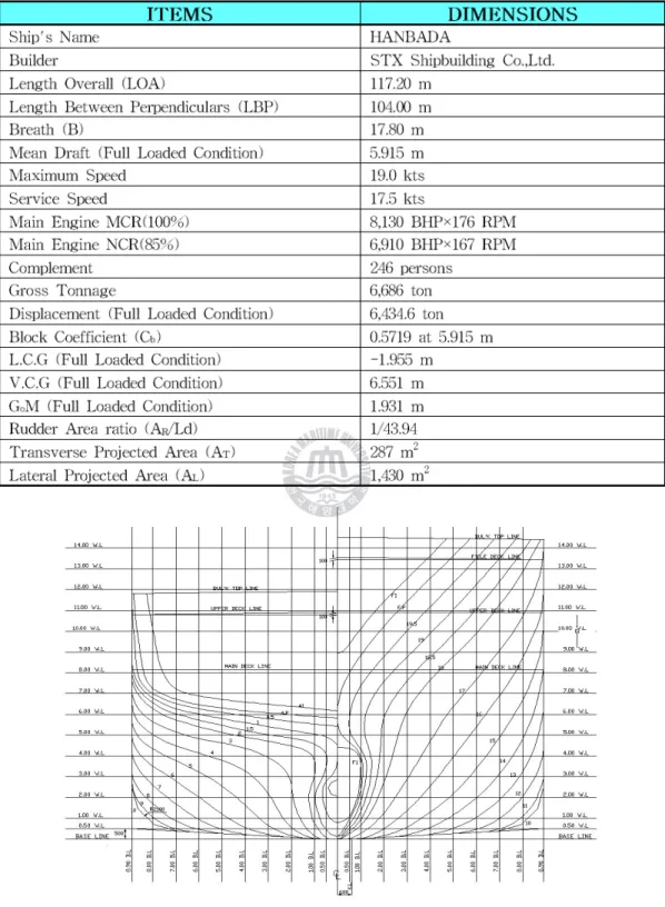
Figure 2.2 Body Plan of T.S. HANBADA
6 1,2,3,7 6
1,2,3,7
AC220V, 60Hz, 1ph
SIGNAL CONDITION
BOX
AC220V, 60Hz, 1ph
UPS DATA LOGGER/
DISPLAY UNIT
AMS
(COMMON ABNOR. ALARM) BOW ACCELEROMETER
INCLINOMETER AFT ACCELEROMETER
SPEED LOG
LOAD COMPUTER
VDR
M/E RPM
LAN SYSTEM JUNCTION
BOX
LONG BASED STRAIN GAUGE FWD
LONG BASED STRAIN GAUGE MID PORT
LONG BASED STRAIN GAUGE MID ST'BD
LONG BASED STRAIN GAUGE AFT
DGPS
WIND DIRECTION/SPEED
PC time Year/month/date from
GPS(UTC)
time from GPS(UTC)
speed from GPS
heading from
GPS latitude longitude fwd port
max stress
f.p mean stress
f.p min stress
f.p p-to-p
f.p stdv
f.p rms
f.p period mid port
max stress
mid port mean stress
mid port min stress
mid port p-to-p
mid port stdv
mid port rms
mid port period mid stbd
max stress
mid stbd mean stress
mid stbd min stress
mid stbd p-to-p
mid stbd stdv
mid stbd rms
mid stbd period aft port
max stress
aft port mean stress
aft port min stress
aft port p-to-p
aft port stdv
aft port rms
aft port period fwd accele. max fwd.a mean fwd.a min fwd.a p-to-p fwd.a stdv fwd.a rms fwd.a period
aft accele. max aft.a mean aft.a min aft.a p-to-p aft.a stdv aft.a rms aft.a period Trim angle max t.a mean t.a min t.a p-to-p t.a stdv t.a rms t.a period Heel angle max h.a mean h.a min h.a p-to-p h.a stdv h.a rms h.a period engine rpm max e.rpm mean e.rpm min e.rpm p-to-p e.rpm stdv e.rpm rms e.rpm period
log speed max l.s mean l.s min l.s p-to-p l.s stdv l.s rms l.s period wind speed max w.s mean w.s min w.s p-to-p w.s stdv w.s rms w.s period wind direc. max w.d mean w.d min w.d p-to-p w.d stdv w.d rms w.d period fwd swbm (ton-m) fwd wbm
mid swbm (ton-m) mid wbm aft swbm (ton-m) aft wbm
fwd port offset mid port offset mid stbd offset aft port offset fwd accel. offset
˚
˚
SHIP
CHARACTERISTICS
SEA CONDITIONS SEAKEEPING
TOOLS SEAKEEPING CHARACTERISTICS
DESIGN ASSESSMENT
OPERATOR GUIDANCE
OPERATIONAL CRITERIA
Date Position True
Course Speed Wind Direction
Wind Force
Sea
State Route
06051004 25-39N
122-57E 210 14.75 S 4 3 BUSAN-RANGOON
06051008 25-50N
122-34E 199 14.25 SSE 4 4 BUSAN-RANGOON
06051012 24-01N
122-11E 199 12.75 SSE 4 4 BUSAN-RANGOON
06051016 23-09N
121-50E 199 13.75 SSE 4 4 BUSAN-RANGOON
06051020 22-16N
121-27E 206 14.25 SE 3 3 BUSAN-RANGOON
06051024 21-25N
120-58 221 14.25 NE 3 3 BUSAN-RANGOON
06102504 06-47N
106-22E 170 16.00 NNE 5 5 BUSAN-SINGAPORE
06102508 06-50N
107-12E 170 16.25 NNE 4 4 BUSAN-SINGAPORE
06102512 06-53N
108-02E 040 15.25 NE 5 5 BUSAN-SINGAPORE
06102516 07-42N
108-44E 041 16.25 NNE 5 4 BUSAN-SINGAPORE
06102520 08-28N
109-24E 041 15.00 NE 4 4 BUSAN-SINGAPORE
06102524 07-34N
108-38E 221 17.00 NNE 3 3 BUSAN-SINGAPORE
06103104 04-19N
105-57E 039 15.50 NNE 5 4 SINGAPORE-CEBU
06103108 04-44N
106-56E 074 15.50 NNE 5 4 SINGAPORE-CEBU
Date Position True
Course Speed Wind Direction
Wind Force
Sea
State Route
06052204 RANGOON
PORT BERTHED SE 3 3 AT RANGOON
06052208 RANGOON
PORT BERTHED SE 3 3 AT RANGOON
06052212 RANGOON
PORT BERTHED SSW 3 3 AT RANGOON
06052216 15-20N
096-44E 176 13.75 S 3 3 RANGOON-KEELUNG
06052220 14-20N
096-44E 180 15.50 S 4 4 RANGOON-KEELUNG
06052224 13-14N
096-41E 180 16.25 SW 6 5 RANGOON-KEELUNG
06110804 14-30N
125-00E 018 16.25 ENE 5 4 CEBU-KOBE
06110808 15-34N
125-22E 018 15.75 ENE 5 4 CEBU-KOBE
06110812 16-31N
125-40E 018 15.00 ENE 5 5 CEBU-KOBE
06110816 17-28N
126-00E 018 14.75 NNE 5 5 CEBU-KOBE
06110820 18-24N
126-15E 018 14.50 ENE 5 5 CEBU-KOBE
06110824 19-19N
126-39E 018 14.50 NE 6 5 CEBU-KOBE
06110904 20-14N
126-57E 018 14.25 NE 6 5 CEBU-KOBE
06110908 21-12N
127-17E 018 15.00 NE 6 5 CEBU-KOBE
Date Position True
Course Speed Wind Direction
Wind Force
Sea
State Route
06060304 28-03N
126-26E 049 17.50 NW 6 6 KEELUNG-YOKOHAMA
06060308 28-45N
127-30E 049 17.00 N 7 6 KEELUNG-YOKOHAMA
06060312 29-33N
128-10E 049 12.00 NNE 6 6 KEELUNG-YOKOHAMA
06060316 29-51N
129-08E 049 15.75 NE 6 6 KEELUNG-YOKOHAMA
06060320 30-23N
129-38E 065 16.75 NE 6 6 KEELUNG-YOKOHAMA
06060324 30-56N
131-03E 065 17.33 NE 5 5 KEELUNG-YOKOHAMA
07102804 15-01N
114-33E 027 15.75 NE 6 6 JAKARTA-TIANJIN
07102808 15-56N
115-04E 027 14.00 NE 6 6 JAKARTA-TIANJIN
07102812 16-48N
115-30E 027 14.50 NE 6 6 JAKARTA-TIANJIN
07102816 17-30N
115-53E 027 14.00 NE 6 6 JAKARTA-TIANJIN
07102820 18-26N
116-24E 027 13.50 NE 7 6 JAKARTA-TIANJIN
07102824 19-01N
116-42E 027 10.00 NE 7 6 JAKARTA-TIANJIN
07102904 19-46N
117-06E 027 14.00 NE 6 6 JAKARTA-TIANJIN
07102908 20-40N
117-35E 027 14.00 NE 7 6 JAKARTA-TIANJIN
Date Position True
Course Speed Wind Direction
Wind Force
Sea
State Route
06060404 31-25N
132-06E 062 15.50 NE 5 5 KEELUNG-YOKOHAMA
06060408 31-57N
133-15E 062 15.75 NE 6 5 KEELUNG-YOKOHAMA
06060412 33-30N
134-20E 057 16.00 NE 8 7 KEELUNG-YOKOHAMA
06060416 33-00N
135-23E 050 15.25 NE 8 7 KEELUNG-YOKOHAMA
06060420 33-37N
136-20E 051 15.00 NE 7 7 KEELUNG-YOKOHAMA
06060424 34-11N
137-21E 078 16.00 ENE 6 6 KEELUNG-YOKOHAMA
07103004 23-48N
119-13E 023 04.25 NE 7 7 JAKARTA-TIANJIN
07103008 24-15N
119-25E 023 06.50 NNE 8 7 JAKARTA-TIANJIN
07103012 24-43N
119-51E 040 09.00 NNE 8 7 JAKARTA-TIANJIN
07103016 25-07N
120-12E 040 08.75 NNE 8 7 JAKARTA-TIANJIN
07103020 25-50N
120-50E 040 12.50 NE 8 6 JAKARTA-TIANJIN
07103024 26-33N
121-03E 055 13.25 NE 7 6 JAKARTA-TIANJIN
2 3 4 5 6 7 8 0.0
0.2 0.4 0.6 0.8 1.0 1.2 1.4
Operational Survival
S i g n i f i c a n t M a x i m u m
Vertical Acceleration [g]
180 150 120 90 60 30 0 0.0
0.2 0.4 0.6 0.8 1.0 1.2 1.4
Operational Survival
Sea State 4 (H1/3: 1.88m ) Sea State 5 (H1/3: 3.25m ) Sea State 6 (H1/3: 5.00m )
Vertical Acceleration [g]
En c o u n t e r A n g l e [d e g ]
Following Sea Head Sea
Date Position True
Course Speed Wind Direction
Wind Force
Sea State
Encounter Angle 06102504 06-47N
106-22E 170 16.00 NNE 5 5 following sea
06102508 06-50N
107-12E 170 16.25 NNE 4 4 following sea
06102512 06-53N
040 15.25 NE 5 5 head sea
Head Sea Bow Sea
Date Position True
Course Speed Wind Direction
Wind Force
Sea State
Encounter Angle
06110904 20-14N
126-57E 018 14.25 NE 6 5 head sea
06110908 21-12N
127-17E 018 15.00 NE 6 5 head sea
06110912 22-12N
127-38E 018 15.75 NE 6 5 head sea
06110916 23-12N
128-00E 018 15.75 ENE 5 5 bow sea
06110920 23-50N
128-15E 018 16.00 ENE 5 5 bow sea
06110924 24-40N
128-31E 018 16.33 ENE 5 5 bow sea
Beam Sea Head Sea
Date Position True
Course Speed Wind Direction
Wind Force
Sea State
Encounter Angle
06060304 28-03N
126-26E 049 17.50 NW 6 6 beam sea
06060308 28-45N
127-30E 049 17.00 N 7 6 bow sea
29-33N
2 3 4 5 0.0
0.2 0.4 0.6 0.8 1.0 1.2 1.4
Operational Survival
O c e a n C o a s t a l
Vertical Acceleration [g]
S i g n i f i c a n t W a v e H e i g h t [m ]
Date Position True
Course Speed Wind Direction
Wind Force
Sea
State Route
06042000 35-46N
129-37E 187 17.00 W 7 5 Tonghae-Busan
06042002 35-05N
129-20E 187 15.25 WSW 7 5 Tonghae-Busan
Date Position True
Course Speed Wind Direction
Wind Force
Sea
State Route
07040404 34-45N
125-06E 009 17.00 NW 6 5 Cheju-Busan
07040408 35-48N
125-50E 009 15.00 NNW 7 5 Cheju-Busan
07040412 35-48N
125-37E 176 15.50 NNW 5 5 Cheju-Busan
07040416 34-35N
125-45E 165 15.50 NW 6 5 Cheju-Busan
07040420 34-05N
126-50E 085 17.00 W 5 4 Cheju-Busan
07040424 34-18N
128-03E 070 15.75 W 4 4 Cheju-Busan
㎥
2 3 4 5 6 0.0
0.1 0.2 0.3 0.4 0.5 0.6 0.7 0.8 0.9 1.0
O p e r a t i o n a l S u r v i v a l C a l u l a t i o n
M o d e l T e s t M e a s u r e m e n t
Vertical Acceleration[g]
S i g n i f i c a n t W a v e H e i g h t [m ]
˚
˚
˚ ˚
˚
2 3 4 5 6
0 2 4 6 8 10 12 14 16 18 20
O p e r a t io n a l S u r v i v a l C a l u l a t i o n
M o d e l T e s t M e a s u r e m e n t
Amplitude of Pitch [deg]
S i g n i f i c a n t W a v e H e i g h t [m ]
˚
˚
˚
˚
˚
˚
˚ ˚
˚
2 3 4 5 6
0 2 4 6 8 10 12 14 16 18 20
O p e r a t i o n a l C a l u l a t io n
M o d e l T e s t M e a s u r e m e n t
Amplitude of Roll [deg]
S i g n i f i c a n t W a v e H e i g h t [m ]
˚
˚
˚
˚
˚
˚
χ
σ
χ
∞ω χ ωχ
°
° ° °
∞
⋅
π
파수
∞
σ
σ
χ
μ
≧ μ
μ μ μ
α σ
σ
σ
σ
⋅σ
σ
α
σ
σ
μ
μ
α μ
⋅
⋅
⋅
⋅
˚
˚ ˚
0.7 0.8 0.9 1.0 1.1 1.2 1.3 1.4 1.5 1.6 1.7 1.8 1.9 2.0
MU(D) MU(PR) MU(S) MU(R) MU(AV) MU(AT) Index
Dangerousness
180 150 120 90 60 30 0 0.00.10.20.30.40.50.60.70.80.91.0
1.11.2 1.3 1.4 1.5 1.6 1.7 1.8 1.9 2.0
MU(D) MU(PR) MU(S) MU(R) MU(AV) MU(AT) Index
Dangerousness
Encounter Angle(degree)
180 150 120 90 60 30 0
0.0 0.1 0.20.3 0.4 0.5 0.6 0.7 0.8 0.9 1.0 1.1 1.2 1.3 1.4 1.5 1.6 1.7 1.8 1.9 2.0
MU(D) MU(PR) MU(S) MU(R) MU(AV) MU(AT) Index
Dangerousness
Encounter Angle(degree)
180 150 120 90 60 30 0 0.0
0.1 0.2 0.3 0.4 0.5 0.6 0.7 0.8 0.9 1.0 1.1 1.2 1.3 1.4 1.5 1.6 1.71.8 1.9 2.0
MU(D) MU(PR) MU(S) MU(R) MU(AV) MU(AT) Index
Dangerousness
Encounter Angle(degree)
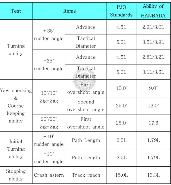
Test Item IMO Standards
Turning ability
+35˚
rudder angle
Advance 4.5L
Tactical Diameter 5.0L -35˚
rudder angle
Advance 4.5L
Tactical Diameter 5.0L
Yaw checking &
Course keeping ability
10 /10˚ ˚ Zig-Zag
First
overshoot angle 10.0˚
Second
overshoot angle 25.0˚
20 /20˚ ˚ First Table 4.1
˚ ˚
˚
˚
˚
˚
˚ ˚ ˚
˚ ˚ ˚
˚
˚ ˚ ˚
˚ ˚
˚ ˚
˚ ˚ ˚
˚ ˚ ˚ ˚
˚
˚ ˚ ˚ ˚ ˚
˚
˚ ˚ ˚
˚ ˚ ˚
Date Item
2005. 11. 18 2007. 5. 20 2007. 5. 29 Displacement
(ton) 5529 6125 5846
Draft(F/M/A)
(m) 4.6/5.3/5.8 5.3/5.7/6.1 5.3/5.5/5.7 Trim
(m) 1.2 0.8 0.4
Table 4.2
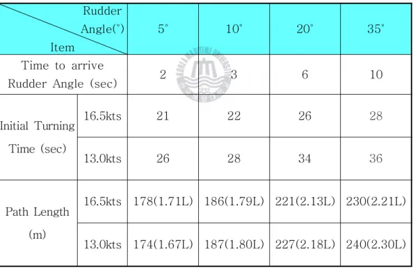
Table 4.3 Initial Turning Time of T.S. HANBADA Rudder
Angle( )˚ Item
5˚ 10˚ 20˚ 35˚
Time to arrive
Rudder Angle (sec) 2 3 6 10
Initial Turning Time (sec)
16.5kts 21 22 26 28
13.0kts 26 28 34 36
Path Length (m)
16.5kts 178(1.71L) 186(1.79L) 221(2.13L) 230(2.21L)
13.0kts 174(1.67L) 187(1.80L) 227(2.18L) 240(2.30L)
Rudder Angle( )˚ Item
Port 35˚ Stb'd 35˚
Sea trial Measurement Sea trial Measurement Speed(Initial/End)
(kts) 17.6/6.0 12.9/5.9 17.5/6.8 12.3/5.9 Advance
(m) 329(3.2LBP) 294(2.8LBP) 311(3.0LBP) 302(2.9LBP) Table 4.4 Turning Ability of T.S. HANBADA
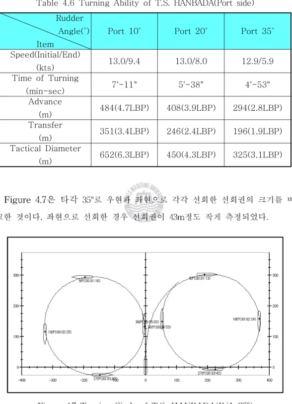
가 2.9L이고 전술선회경, 이 3.5L로 측정 되었다 이는. IMO에서 요구하는 조종성 기준의 종거(4.5L) 및
의 범위를 잘 만족하고 있다
L) .
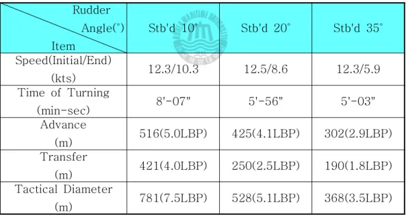
Table 4.5 Turning Ability of T.S. HANBADA(Starboard side) Rudder
Angle( )˚ Item
Stb'd 10˚ Stb'd 20˚ Stb'd 35˚
Speed(Initial/End)
(kts) 12.3/10.3 12.5/8.6 12.3/5.9
Time of Turning
(min-sec) 8'-07" 5'-56" 5'-03"
Advance
(m) 516(5.0LBP) 425(4.1LBP) 302(2.9LBP) Transfer
(m) 421(4.0LBP) 250(2.5LBP) 190(1.8LBP) Tactical Diameter
(m) 781(7.5LBP) 528(5.1LBP) 368(3.5LBP)
가 2.8L이고 전술선회경, 이 3.1L로 측정 되었다 좌현 또한. IMO에서 요구하는 조종성 기준의 종거(4.5L) 및
의 범위를 잘 만족하고 있다
L) .
Table 4.6 Turning Ability of T.S. HANBADA(Port side) Rudder
Angle( )˚ Item
Port 10˚ Port 20˚ Port 35˚
Speed(Initial/End)
(kts) 13.0/9.4 13.0/8.0 12.9/5.9
Time of Turning
(min-sec) 7'-11" 5'-38" 4'-53"
Advance
(m) 484(4.7LBP) 408(3.9LBP) 294(2.8LBP) Transfer
(m) 351(3.4LBP) 246(2.4LBP) 196(1.9LBP) Tactical Diameter
(m) 652(6.3LBP) 450(4.3LBP) 325(3.1LBP)
Table 4.7 Comparison between Turning Abilities
Test Items IMO
Standards
Ability of HANBADA
Turning ability
+35˚
rudder angle
Advance 4.5L 2.9L/3.0L
Tactical
Diameter 5.0L 3.5L/3.9L -35˚
rudder angle
Advance 4.5L 2.8L/3.2L
Tactical
Diameter 5.0L 3.1L/3.6L Yaw checking
&
Course keeping
ability
10 /10˚ ˚ Zig-Zag
First
overshoot angle 10.0˚ 9.0˚
Second
overshoot angle 25.0˚ 12.0˚
20 /20˚ ˚ Zig-Zag
First
overshoot angle 25.0˚ 17.6 Initial
Turning ability
+10˚
rudder angle Path Length 2.5L 1.79L -10˚
rudder angle Path Length 2.5L 1.79L Stopping
ability Crash astern Track reach 15.0L 13.3L
δ
ϕ ϕ δ
δ δ
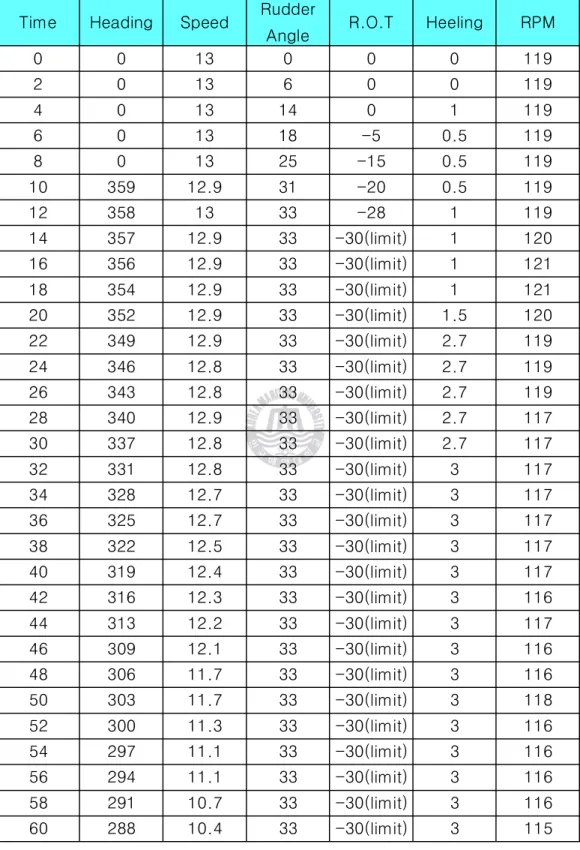
Time Heading Speed Rudder
Angle R.O.T Heeling RPM
0 0 13 0 0 0 119
2 0 13 6 0 0 119
4 0 13 14 0 1 119
6 0 13 18 -5 0.5 119
8 0 13 25 -15 0.5 119
10 359 12.9 31 -20 0.5 119
12 358 13 33 -28 1 119
14 357 12.9 33 -30(limit) 1 120
16 356 12.9 33 -30(limit) 1 121
18 354 12.9 33 -30(limit) 1 121
20 352 12.9 33 -30(limit) 1.5 120
22 349 12.9 33 -30(limit) 2.7 119
24 346 12.8 33 -30(limit) 2.7 119
26 343 12.8 33 -30(limit) 2.7 119
28 340 12.9 33 -30(limit) 2.7 117
30 337 12.8 33 -30(limit) 2.7 117
32 331 12.8 33 -30(limit) 3 117
34 328 12.7 33 -30(limit) 3 117
36 325 12.7 33 -30(limit) 3 117
38 322 12.5 33 -30(limit) 3 117
40 319 12.4 33 -30(limit) 3 117
42 316 12.3 33 -30(limit) 3 116
44 313 12.2 33 -30(limit) 3 117
46 309 12.1 33 -30(limit) 3 116
48 306 11.7 33 -30(limit) 3 116
50 303 11.7 33 -30(limit) 3 118
52 300 11.3 33 -30(limit) 3 116
54 297 11.1 33 -30(limit) 3 116
56 294 11.1 33 -30(limit) 3 116
58 291 10.7 33 -30(limit) 3 116
60 288 10.4 33 -30(limit) 3 115
Table 4.8 Test for Maneuvering Performance Index (Port 35°)
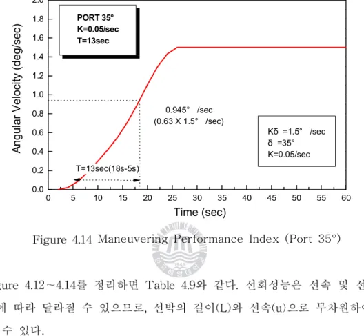
0 5 10 15 20 25 30 35 40 45 50 55 60 0.0
0.2 0.4 0.6 0.8 1.0 1.2 1.4 1.6 1.8 2.0
PORT 10°
K=0.1/sec T=20sec
T=20sec(21s-1s)
0.63° /sec (0.63 X 1.0° /sec)
Kδ =1.0° /sec δ =10°
K=0.1/sec
Angular Velocity (deg/sec)
Time (sec)
Maneuvering Performance Index (Port 10°)
1.0 1.2 1.4 1.6 1.8 2.0
PORT 20°
K=0.06/sec T=17sec
Velocity (deg/sec)
0 5 10 15 20 25 30 35 40 45 50 55 60 0.0
0.2 0.4 0.6 0.8 1.0 1.2 1.4 1.6 1.8 2.0
PORT 35°
K=0.05/sec T=13sec
T=13sec(18s-5s)
0.945° /sec (0.63 X 1.5° /sec)
Kδ =1.5° /sec δ =35°
K=0.05/sec
Angular Velocity (deg/sec)
Time (sec)
Maneuvering Performance Index (Port 35°)
타 각( )δ K 선회성 지수
( )
T 추종성 지수
( )
K' (K L/u)ㆍ
T' (T u/L)ㆍ
최초 속력(Knot)
Port 10° 0.10 20 0.80 2.50 13.0
Port 20° 0.06 17 0.42 2.13 13.0
Port 35° 0.05 13 0.40 1.63 13.0
Table 4.9 Maneuvering Performance Index of T.S. HANBADA
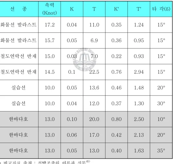
선 종 속력
(Knot) K T K' T' 타 각( )δ
화물선 발라스트 17.2 0.04 11.0 0.35 1.24 15°
화물선 발라스트 15.7 0.05 6.9 0.36 0.95 15°
철도연락선 반재 15.0 0.03 7.0 0.22 0.93 15°
철도연락선 반재 14.5 0.1 22.5 0.76 2.94 15°
실습선 10.0 0.05 13.6 0.46 1.48 20°
실습선 10.0 0.04 12.0 0.37 1.30 30°
한바다호 13.0 0.10 20.0 0.80 2.50 10°
Table 4.10 Comparison of Maneuvering Performance Index
˚ ˚
˚ ˚ ˚
30˚
60˚
90˚
˚
˚ ˚ ˚ ˚
˚
˚ ˚ ˚
˚ ˚
90˚
60˚
30˚
˚
˚ ˚ ˚
90˚
60˚
30˚
˚
Starboard Port
10˚
10˚
20˚ 20˚
35˚ 35˚
˚ ˚
˚ ˚ ˚
˚
δ
θ β
Va U
x
y N
X
Y
δ δ
δ
²
²ρ Cy(θ) CN(θ)
θ
Table 4.12
θ θ θ
θ
θ
0 30 60 90 120 150 180 0
10 20 30 40 50 60 70 80 90
5 m/s 10 m/s 15 m/s 20 m/s 30 m/s
Wind Force, Fy [ton]
Relative Wind Direction [deg]
β β
′
′ρ
β
β
β
′
′
′
′
κ
τ
δ δ
′
′d ' (1 )cosd
2
H R r
R K a
U A U
Y ÷ +
ø ç ö è - æ
=
d ' ( )cosd
2
H H R R r
R K x a x
U A U
N ÷ +
ø ç ö è - æ
=
′
′
′
′ ρ ρ∼
∼
∼
∼
∼
∼
∼
∼
∼
∼
∼
∼
∼
0 5 10 15 0
5 10 15 20 25 30
Bow(5.0)+Tug(8.4) Bow(6.9)+Tug(11.6)
Wind Force * 1.0 Wind Force * 1.5
Wind Force (ton)
Max. Wind Speed (m/s)
Table 4.17
Table 4.18
10 15 20 25 30 35 40 45 0
10 20 30 40 50 60 70 80
Wind Force * 1 Wind Force * 2 Wind Force * 3
Wind Force, Fx (ton)
Max. Wind Speed(Velocity) (m/s)
λ λ
λ λ
α α
PT
HT
C PP
PS
αP
αS
˚
λ λ
10 15 20 25 30 35 40 45 50 0
10 20 30 40 50 60 70 80 90 100
7 Shackles 8 Shackles 9 Shackles
H ol di ng P ow er ( to n)
Max. Wind Speed (m/s)
˚
α α α α ˚
˚
˚
λ λ
α α α α ˚
10 15 20 25 30 35 40 45 50 0
10 20 30 40 50 60 70 80 90 100
9+9 Shackles 7+2 Shackles 8+2 Shackles 9+2 Shackles
H o ld in g P o w e r (t o n)
Max. Wind Speed (m/s)
α α α α ˚
α α α α ˚
λ λ
α α α α ˚
α α α α ˚
10 15 20 25 30 35 40 45 50 0
10 20 30 40 50 60 70 80 90 100
Wind Force * 1 Wind Force * 2 Wind Force * 3 7 Shackles 8 Shackles 9 Shackles
W in d F o rc e & H o ld in g P o w e r (t o n )
Max. Wind Speed (m/s)
40 50 60 70 80 90 100
e & Holding Power (ton) Wind Force * 1
Wind Force * 2 Wind Force * 3 9+9 Shackles 7+2 Shackles 8+2 Shackles 9+2 Shackles
˚ ˚ ˚ ˚
˚ ˚
θ
K N
˚
ϕ
˚
θ θ
Angle KN (m) KG
o×sinθ G
oZ (m)
5 0.779
0.608
0.17110 1.545
1.212
0.33320 3.043
2.387
0.65630 4.478
3.490
0.98840 5.721
4.487
1.234Example of GoZ Curve
∆
θ
θ
θ θ
f)
˚Draft(mld) (m)
Area (m2)
Center (m)
draft/2 (m)
Moment (m3)
Z (m)
Disp.
(ton)
LW1 (m) 3.00 1651.00 10.99 1.50 18144.49 9.49 2658.5 0.3029 4.00 1515.00 11.61 2.00 17589.15 9.61 3833.0 0.1952 5.00 1430.00 12.05 2.50 17231.50 9.55 5133.6 0.1367 5.90 1353.00 12.47 2.95 16871.91 9.52 6434.6 0.1029 7.00 1235.00 13.05 3.50 16116.75 9.55 8217.2 0.0738 8.00 1126.00 13.59 4.00 15302.34 9.59 9943.6 0.0558
Upper Deck Shelterer Deck
* Y : Distance from Center Line Z : Distance from Base Line
Point 1 : Shelter Deck)
Point 2 : Upper Deck)
θ ˚
θ ˚ ˚
θ
θ ˚ ˚
θ ˚
θ
θ
˚
˚
˚
˚
˚
GoZ Curve(
θ ˚
θ ˚ θ
θ ˚ θ ˚ θ
θ ˚
˚
θ ˚ θ
θ θ θ
˚ ˚
GoZ Curve(
θ ˚
θ ˚ θ
θ ˚ θ ˚ θ
θ ˚
˚ ˚
GoZ Curve(
θ ˚
θ ˚ θ
θ ˚ θ ˚ θ
θ ˚
˚
θ ˚ θ
θ θ θ
˚ ˚
GoZ Curve(
θ ˚
θ ˚ θ
θ ˚ θ ˚ θ
θ ˚
˚
˚
GoZ Curve(
θ ˚
θ ˚ θ
θ ˚ θ ˚ θ
θ ˚
˚
θ ˚ θ
θ θ θ
²
θ
3 4 5 6 7
5 m/s 10 m/s 15 m/s 20 m/s 30 m/s
g Angle [deg]
˚ ˚
˚
θ ˚
2 3 4 5
0 2 4 6 8 10 12 14 16 18 20
Operational
S i g n i f i c a n t M a x i m u m
Amplitude of Roll[deg]
S ig n i f ic a n t Wa v e He i g h t [m ]
Sea state 4 최대값
- : 13˚
유의치 -1/3 : 10˚
-Quartering sea
Sea state 5 최대값
- : 15˚
유의치 -1/3 : 12˚
-Beam sea
Rolling(2007.10.17)
˚ ˚
Wave crest
Wave crest Wave direction
Wave crest
V : Ship's speed Vw : Wave velocity
θ
: Wave length λ