Korean Journal of Remote Sensing, Vol.35, No.2, 2019, pp.337~342
https://doi.org/10.7780/kjrs.2019.35.2.12 ISSN 1225-6161 ( Print )
ISSN 2287-9307 (Online)
Letter
기상예보모델자료와 위성자료를 이용한 산불위험지수 개발 및 2019년 4월 강원 산불 사례에의 적용
김영호1)·공인학2)·정주용3)·신인철4)·정성훈5)·정원찬6)·모희숙7)·김상일8)·이양원 9)†
Wildfire Risk Index Using NWP and Satellite Data:
Its Development and Application to 2019 Kangwon Wildfires
Yeong-Ho Kim
1)·In-Hak Kong
2)·Chu-Yong Chung
3)·Inchul Shin
3)·Seonghoon Cheong
5)· Won-Chan Jung
6)·Hee-Sook Mo
7)·Sang-Il Kim
8)·Yang-Won Lee
9)†Abstract: This letter describes the development of WRI (Wildfire Risk Index) using GDAPS (Global Data Assimilation and Prediction System) and satellite data, and its application to the Goseong-Sokcho and Gangneung-Donghae wildfires in April 4, 2019. We made sure that the proposed WRI represented the change of wildfire risk of around March 19 and April 4 very well. Our approach can be a viable option for wildfire risk monitoring, and future works will be necessary for the utilization of GK-2A products and the coupling with the wildfire prediction model of the Korea Forest Service.
Key Words: GK-2A, Numerical weather prediction, Vegetation dryness index, Wildfire risk
요약 : 본 연구에서는GDAPS(Global Data Assimilation and Prediction System) 예보모델자료와 위성기반 식생건 조지수를 결합시킨 산불위험지수WRI(Wildfire Risk Index)를 개발하였고, 이를 2019년 4월 4일의 고성-속초 산Received April 22, 2019; Revised April 23, 2019; Accepted April 23, 2019; Published online April 25, 2019
1)
부경대학교 지오매틱연구소 전임연구원 (Researcher, Geomatics Research Institute, Pukyong National University)
2)
(주)가이아쓰리디 연구원 (Researcher, Gaia 3D Incorporation)
3)
국가기상위성센터 차세대위성개발팀 연구관 (Senior Research Scientist, Satellite Development Division, National Meteorological Satellite Center)
4)
국가기상위성센터 차세대위성개발팀 연구사 (Research Scientist, Satellite Development Division, National Meteorological Satellite Center)
5)
국가기상위성센터 차세대위성개발팀 과장 (Director, Satellite Development Division, National Meteorological Satellite Center)
6)
한국전자통신연구원 기상위성알고리즘개발실 실장 (Director, Meteorological Satellite Ground Segment Algorithm Section, Electronics and Telecommunications Research Institute)
7)
한국전자통신연구원 기상위성알고리즘개발실 책임연구원 (Senior Research Scientist, Meteorological Satellite Ground Segment Algorithm Section, Electronics and Telecommunications Research Institute)
8)
한국전자통신연구원 기상위성알고리즘개발실 선임연구원 (Research Scientist, Meteorological Satellite Ground Segment Algorithm Section, Electronics and Telecommunications Research Institute)
9)
부경대학교 공간정보시스템공학과 교수 (Professor, Department of Spatial Information Engineering, Pukyong National University)
†Corresponding Author: Yang-Won Lee ([email protected])
This is an Open-Access article distributed under the terms of the Creative Commons Attribution Non-Commercial License
(http://creativecommons.org/licenses/by-nc/3.0) which permits unrestricted non-commercial use, distribution, and reproduction in
any medium, provided the original work is properly cited.
1. 서 론
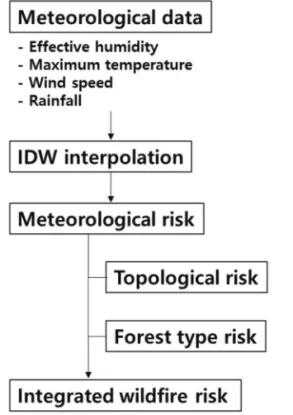
산불은 한번 발생하면 바람과 지세의 영향이나 인력 과 장비의 제약 때문에 빠른 시간 내에 넓은 면적으로 확산되는 경우가 많다 (Kong et al., 2017). 따라서 큰 피해 가 발생하지 않도록 사전에 대비하기 위하여, 산불취약 성을 시공간 연속적으로 상시 감시하는 것이 매우 중요 하다. 산불의 발생은 주로 기상인자의 영향을 받는데, 산림자원이 풍부한 해외 주요국의 산불위험모형에서 는 온도 , 습도, 강수, 풍속 등을 이용하여 대기 및 지면 의 건조도를 계산해서 산불위험도의 기준으로 삼는 것 이 일반적이다 . 우리나라 산림청의 산불위험예보시스 템도 유사한 방식이지만 (Fig. 1), 유클리드 거리 기반의 IDW(inverse distance weighting) 내삽을 사용하기 때문
에 , 지형의 복잡성이 큰 우리나라에서 기상인자의 공간 이질성을 충분히 고려하기 힘들다는 점에서는 개선의 여지가 있다 .
Kong et al.(2017)의 연구에서는 국외에서 제시된 6종 류의 격자형 산불위험모형에 대한 비교평가를 통하여 , FFDI(Forest Fire Danger Index)가 우리나라 산불위험 도를 나타내기에 적합함을 정량적으로 제시한 바 있다 . 이에 본 연구에서는 GK-2A 위성 활용을 염두에 두고, 기상예보모델 GDAPS(Global Data Assimilation and Prediction System) 자료 기반의 FFDI 지역최적화 모형에 위성기반 식생건조지수 VDI(Vegetation Dryness Index) 를 결합한 산불위험지수 WRI(Wildfire Risk Index)를 개 발하였으며, 이를 2019년 4월 강원 산불 사례에 적용한 결과를 긴급히 소개 및 논의하고자 한다 .
2. 자료와 방법
FFDI는호주의현업산불위험지수로서KBDI(Keetch- Byram Drought Index)에 기초한 가뭄인자 및 상대습도, 기온 , 풍속, 연강수량, 무강수일수, 일강수량 등을 이용 하여 계산한다 (Schunk et al., 2013). 본 연구에서는 지역 최적화를 위하여 우리나라의 월별 산불발생 건수와 월 별 KBDI 평균값이 적절한 선형상관을 이루도록, FFDI 에 포함된 경험상수들을 수정하여 사용하였다 . FFDI 계산에 입력자료로 사용한 GDAPS는 4차원변분법 적 용으로 예측정확도가 향상되었으며 , 0.1도 해상도의 12 일 예측이 가능하다 (Table 1). 본 연구에서는 2013년 1월 부터 2018년 12월까지 남한 영역에 대하여 시간해상도 1일, 공간해상도 0.1도의 FFDI를 산출한 후, 이를 ECDF (empirical cumulative density function)로 변환하여 상대 적 비교가 용이하도록 참조기준자료를 구축하였다.
또한 , 산불의 발생과 확산에 있어 중요한 요소인 식
불과 강릉-동해 산불 사례에 적용해 보았다. 제시한 산불위험지수 WRI는 강수 이벤트 후에 건조 경향이 지속 되었던3월 19일 전후와 4월 4일 전후의 산불위험도 변화를 잘 나타냄으로써, 그 적합성이 확인되었다. WRI는 우리나라 산불취약성의 상시 감시를 위한 하나의 방법이 될 수 있을 것이며, 이를 더욱 발전시키기 위해서는 향후GK-2A 위성자료의 활용과 함께, 산림청의 산불위험예보시스템과의 연계 방안에 대한 모색이 반드시 필 요할 것이다.Fig. 1. Forest fire risk information by Korea Forest Service
(http://forestfire.nifos.go.kr).
생수분함량은 마르지 않은 잎의 무게와 마른 잎의 무게 를 이용한 FMC(Fuel Moisture Content)로 표현할 수 있 지만 (Chuvieco et al., 2003), 직접 측정이 불가능한 경우 에는 위성자료로 대체하기도 한다 . 식생수분지수 NDWI(Normalized Difference Water Index)는 보통 근적 외선 반사도와 단파적외선 반사도의 합과 차를 이용하 여 계산하는데 (Gao, 1996), 이를 역으로 하면 식생건조지 수로 사용할 수 있기 때문에, 본 연구의 VDI는 NDWI 분 자 부분의 좌우 항을 바꾸어 식 (1)과 같이 구성하였다.
VDI = (ρSWIR – ρNIR)/(ρSWIR + ρNIR) (1) 여기에서 , ρSWIR는 단파적외선 반사도, ρNIR은 근적 외선 반사도를 의미한다. 현재 GK-2A의 채널 반사도 자료가 정기적으로 생산되기 이전이므로 우선 MODIS 의 8일합성 반사도 자료를 사용하였으며, FFDI와 동일 한 기간인 2013년 1월부터 2018년 12월까지 남한 영역 에 대하여 시간해상도 8일, 공간해상도 0.1도의 VDI를
산출한 후 , 이를 ECDF로 변환하여 참조기준자료를 구 축하였다 .
본 연구의 산불위험지수는 식 (2)와 같이 FFDI의 ECDF와 VDI의 ECDF를 가중결합시킨 것이며, 가중치
α는 향후 GK-2A 자료 축적과 함께 최적화가 필요한 부분이다 .
WRI = αFFDI + (1 – α)VDI (2)
3. 분석 결과
2019년 4월 4일 오후 7시 17분경에는 강원도 고성군 토성면 원암리에서 화재가 발생하여 속초시 쪽으로 확 산되었으며 (고성-속초 산불), 또한 같은 날 오후 11시 46분경에는 강원도 강릉시 옥계면 남양리에서 산불이 발생하여 동해시 쪽으로 확산되었다 (강릉-동해 산불).
Table 1. Data Assimilation and Prediction System by Korea Meteorological Administration
Model Horizontal Resolution(Vertical Layers) Simulation/day Prediction Period Coverage Global Prediction Model
(GDAPS) 10 km (70) 2 (00,12UTC)2 (06,18UTC) 12 days3 days Global domain Regional Prediction Model
(RDAPS) 12 km (70) 4 87 hours East Asia
Local Prediction Model
(LDAPS) 1.5 km (70) 4 36 hours East Asia
(http://www.kma.go.kr/aboutkma/intro/supercom/model/model_category.jsp)
Fig. 2. Time-series of wildfire risk index for Goseong-Sokcho and Gangneung-Donghae for 20 days
before the wildfire occurrence.
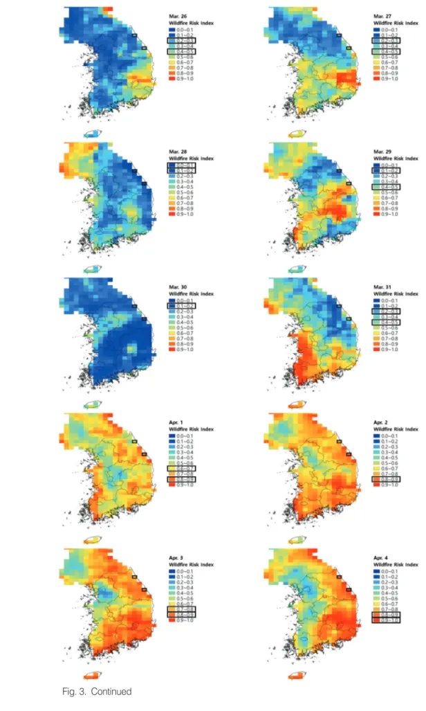
Fig. 3. Wildfire risk index in South Korea for the period between March 26 and April 4, 2019.
Fig. 3. Continued
Fig. 2는 산불발생일 기준으로 최근 20일간의 고성-속초 지역과 강릉 -동해 지역에 대하여 산출한 WRI의 시계열 변화를 나타낸 것이며 , 매우나쁨, 나쁨, 보통, 좋음, 매우 좋음 등의 레이블은 경험적으로 부여된 것으로서 , 향후 세밀한 조정이 필요할 것이다 . GDAPS 자료는 각 날짜 하루 전에 생산된 그 날짜에 대한 예측장을 사용하였고, MODIS 자료는 각 날짜로부터 가장 가까운 8일합성장 을 사용하였다 .
3월 16일로부터 3일후, 3월 21일로부터 3일후, 그리고 3월 30일로부터 3일후 등과 같이, 강수 이벤트 이후에 건 조 경향이 지속되면 3일 정도 후에 WRI 값이 크게 상승 하는 것을 발견할 수 있다 . 이는 상대적으로 높은 기온과 낮은 습도의 지속에 의해 토양과 식생 표면의 수분량이 며칠 만에 감소할 수도 있기 때문이다. 3월 19일에는 고 성-속초, 강릉-동해 두 지역 모두 위험한 상황이었으나, 누전이나 담뱃불 등 실화의 원인이 없었기 때문에 산불 이 발생하지 않았다 . 반면, 정확한 원인규명은 필요할 것 이나 4월 4일에는 실화의 원인 제공으로 인하여 산불이 발생하였고 , 강한 바람을 타고 급격히 확산되었다.
Fig. 3은 남한 전역에 대하여 산출한 WRI를 0.1도 격 자로 나타낸 것으로 , 강원도의 검은 사각형 중에 위쪽이 고성-속초 지역, 아래쪽이 강릉-동해 지역에 해당한다.
3월 19일은 전국적으로 WRI가 매우 높았으며, 4월 2일, 3일, 4일에는 특히 강원도와 경상남북도의 WRI가 높 은 상태를 유지하고 있었는데 , 4월 4일에는 고성-속초, 강릉 -동해, 인제 지역에 3건의 대형산불이 발생하였고, 4월 2일과 3일에도 부산과 포항 등지에서 산불이 발생 하였다 . 이처럼 WRI의 높은 값이 지속되는 지역은 실화 에 각별히 주의하도록 중앙 및 지방 정부에서 여러 방 면으로 사전 대책을 수립할 필요가 있으며, 알림문자 전 송과 같은 대국민 서비스도 하나의 방편이 될 수 있다.
4. 결 론
본 연구에서는 GDAPS 자료 기반의 FFDI 지역최적 화 모형에 위성기반 식생건조지수를 결합시킨 산불위 험지수 WRI를 개발하였고, 이를 2019년 4월의 강원 산 불 사례에 적용하여 그 적합성을 확인하였다. 본 연구 에서 제시한 산불위험지수 WRI는 우리나라 산불취약
성의 상시 감시를 위한 하나의 방법이 될 수 있을 것이 며 , 이를 더욱 발전시키기 위해서는 향후 GK-2A 위성 자료의 활용과 함께 , 산림청의 산불위험예보시스템과 의 연계 방안에 대한 모색이 반드시 필요할 것이다 . 또 한 알림문자 전송과 같은 대국민 서비스도 고려해 볼 필 요가 있다.
사 사
본 연구는 기상청 국가기상위성센터 “정지궤도 기상 위성 지상국 개발 (NMSC-2019-01)” 사업의 일환으로 ETRI에서 추진하는 “융합분야 활용기술 개발” 과제의 지원으로 수행되었습니다.
References
Chuvieco, E., D. Cocero, D. Riano, P. Martin, J. Martinez- Vega, J. Riva, and F. Perez, 2004. Combining NDVI and surface temperature for the estimation of live fuel moisture content in forest fire danger rating, Remote Sensing of Environment, 92(3):
322-331.
Gao, B., 1996. NDWI - A normalized difference water index for remote sensing of vegetation liquid water from space, Remote Sensing of Environment, 58(3):
257-266.
Kong, I., K. Kim, and Y. Lee, 2017. Sensitivity analysis of meteorology-based wildfire risk indices and satellite-based surface dryness indices against wildfire cases in South Korea, Journal of Cadastre
& Land InformatiX, 47(2): 107-120 (in Korean