Vol. 20, No. 4 (2010) pp. 415-426
415
최근 MODIS 식생지수 자료(2006-2008)를 이용한 동아시아 지역 지면피복 분류
강전호·서명석*·곽종흠 공주대학교 대기과학과
(
접수일: 2010
년8
월10
일,
수정일: 2010
년10
월14
일,
게재확정일: 2010
년11
월9
일)
Land Cover Classification over East Asian Region Using Recent MODIS NDVI Data (2006-2008)
Jeon-Ho Kang, Myoung-Seok Suh* and Chong-Heum Kwak
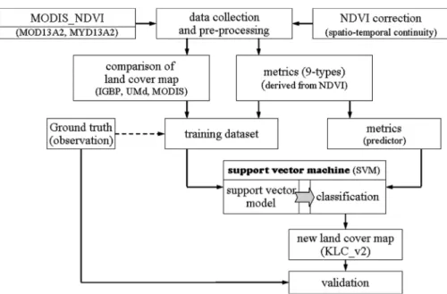
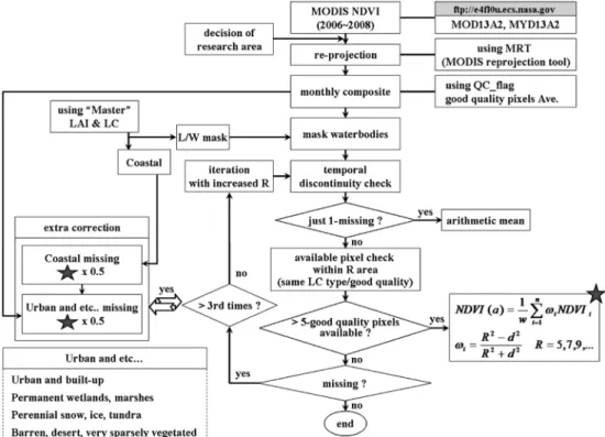
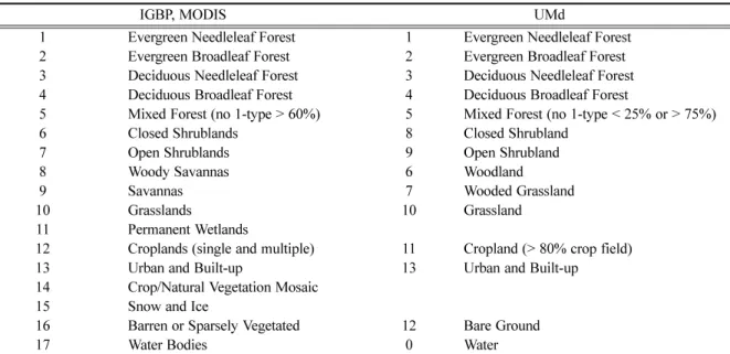
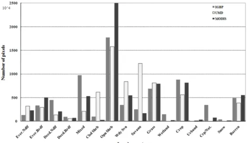
Department of Atmospheric Science, Kongju National University (Received : 10 August 2010, Revised : 14 October 2010, Accepted : 9 November 2010) Abstract : A Land cover map over East Asian region (Kongju national university Land Cover map: KLC) is classified by using support vector machine (SVM) and evaluated with ground truth data. The basic input data are the recent three years (2006-2008) of MODIS (MODerate Imaging Spectriradiometer) NDVI (normalized difference vegetation index) data. The spatial resolution and temporal frequency of MODIS NDVI are 1km and 16 days, respectively. To minimize the number of cloud contaminated pixels in the MODIS NDVI data, the maximum value composite is applied to the 16 days data. And correction of cloud contaminated pixels based on the spatiotemporal continuity assumption are applied to the monthly NDVI data. To reduce the dataset and improve the classification quality, 9 phenological data, such as, NDVI maximum, amplitude, average, and others, derived from the corrected monthly NDVI data. The 3 types of land cover maps (International Geosphere Biosphere Programme: IGBP, University of Maryland: UMd, and MODIS) were used to build up a "quasi" ground truth data set, which were composed of pixels where the three land cover maps classified as the same land cover type. The classification results show that the fractions of broadleaf trees and grasslands are greater, but those of the croplands and needleleaf trees are smaller compared to those of the IGBP or UMd. The validation results using in-situ observation database show that the percentages of pixels in agreement with the observations are 80%, 77%, 63%, 57% in MODIS, KLC, IGBP, UMd land cover data, respectively. The significant differences in land cover types among the MODIS, IGBP, UMd and KLC are mainly occurred at the southern China and Manchuria, where most of pixels are contaminated by cloud and snow during summer and winter, respectively. It shows that the quality of raw data is one of the most important factors in land cover classification.
Keywords : land cover classification, support vector machine, MODIS, NDVI
1. 서 론
지면의 생물리적 특성 변화는 지면과 대기사이의
에너지 및 물 평형 등에 영향을 주어 국지 및 지역기 후를 변화시키는데 중요한 역할을 한다 (Kabat et al. , 2003; Taylor et al. , 2002). 지면의 생물리적 특성은 주
로 지면피복에 의해 결정되기 때문에 이러한 지면피 복의 변화는 알베도 및 거칠기 길이를 변화시키며 , 지
표면온도 및 지면과 대기사이의 열 , 수분 , 운동에너지 교환에도 영향을 미친다 (Chase et al. , 2000). 따라서
†