수치지도 2.0을 이용한 객체기반 데이터 모델 설계
1)임 광 현*, 김 성 호*, 김 형 수 *, 이 훈 **, 류 근 호 *
A Design of Feature-based Data Model Using Digital Map 2.0
Kwang-Hyeon Lim*, Cheng-Hao Jin*, Hyeong-Soo Kim*, Xun Li**, Keun-Ho Ryu*
요 약
공간데이터에 대한 수요가 날로 늘어남에 따라 다양한 공간 객체들을 효과적으로 저장하고 관리할 수 있는 데이 터 모델에 대한 수요도 늘어나게 되었다. 지금까지 수많은 공간데이터 모델에 대한 다양한 데이터 모델들이 제안되 었으나 이런 데이터 모델들은 단지 특정된 기능을 위해 구축되었거나 혹은 구축은 용이하지만 효과적인 관리가 어 렵고 활용성이 떨어지는 문제점들을 가지고 있다. 특히 국내에서 많이 사용되고 있는 수치지도 포맷은 도엽기반으 로 되어 있어 구축은 용이하나 데이터 활용이 어렵고 대부분의 시스템들에서 사용될 수 없다. 따라서 본 연구에서는 도엽기반의 수치지도2.0에 기반한 객체기반의 연속 데이터 모델을 구축함으로서 모델 구축도 용이할 뿐만 아니라 관리하기 편리하고 많은 응용분야에 쉽게 활용할 수 있는 데이터 모델을 제안한다. 제안된 데이터 모델은 도엽단위 가 아닌 객체단위로 데이터를 저장하고 처리하기 때문에 갱신비용이 낮고 신속한 갱신이 가능하다. 또한 지형지물 들 사이의 연관관계에 의하여 자동 검수를 진행할 수 있기 때문에 갱신 데이터의 정확성을 보장할 수 있다. 본 논문 에서 제안된 데이터 모델의 적용성에 대한 검증을 통하여 기존 데이터 모델들로 표현하기 어려운 객체기반 관리시 스템의 특성들에 대하여 제안된 모델이 효율적으로 적용가능 하다는 것을 논리적으로 검증하였다.
▸Keyword : GIS, 수치지도 2.0, 객체기반 데이터 모델, 수시갱신
Abstract
In With increase of a demand on the spatial data, the need of spatial data model which can
∙제1저자 : 임광현 ∙교신저자 : 류근호
∙투고일 : 2012. 03. 03, 심사일 : 2012. 04. 02, 게재확정일 : 2012. 05. 04.
* 충북대학교 데이터베이스/바이오인포매틱스 연구실(Database/Bioinformactics Laboratory, Chungbuk National University)
** 서울시 서초구 반포대로 10, (주)에이텍 (Atec co. Ltd, 10 Banpo Main street, Seocho-Dong, Seocho-Gu, Seoul, Korea)
※ This research was supported by a grant(06KLSGB01) from Cutting-edge Urban Development - Korean Land Spatialization Research Project funded by Ministry of Land, Transport and Maritime Affairs and the National Research Foundation of Korea(NRF) grant funded by the Korea government(MEST)(No.
2012-0000478)
effectively store and manege spatial objects becomes more important in many GIS applications.
There are many researches on the spatial data model. Several data models were proposed for some special functions, however, there are still many problems in the management and applications.
Digital Map is one of spatial data model which is being used in Korea. The existing Digital Map is based on the Tiles. This approach needs more cost in its construction and management. Therefore, in this paper, we propose a feature-based seamless data model with Digital map 2.0 which is based on Tiles. This model can be easily constructed and managed in the large databases so that it is able to apply to any systems. The proposed model uses the relationships between features to correct updated data and the Unique Feature IDentifier(UFID) also makes system to search and manage the feature data more easily and efficiently.
▸Keyword : GIS, Digital Map 2.0, Data Model, Feature-Based
I. INTRODUCTION
Recently, spatial data is widely used in many fields such as ITS, navigation systems, Global Positioning System(GPS)s, mobile applications and so on. With increase of a demand on the spatial data, the request for high quality spatial data is increased. A number of countries have their own spatial data models which are suitable to their geographic characteristic. The shapefile and GML are the most widely used spatial data model [13].
These models are based on file system. It leads to a difficulty in inserting, modifying and deleting a specific spatial object.
In Korea, the most popular data model is Digital Map 2.0 [10]. The Digital Map 2.0 model is an extended version of Digital Map 1.0. These models are constructed by tiles. The model consists of two main files. One represents the shape of these spatial objects and the other one represents common attributes of the spatial objects. The file-based spatial data management system needs high cost and long time for updating process, because the file should be newly constructed when a specific spatial feature is updated. This system cannot satisfy the requirement of users who want to obtain a up-to-data and reliable spatial data. Therefore,
feature-based spatial data management system needs for real time update. Feature-based system manage spatial data with each feature object, it is easy to search and update the specific feature object in real time. However, current spatial data models does not support feature-based systems.
In this paper, we propose a feature-based Seamless Digital Map data model which uses Digital Map 2.0 to support feature-based spatial data management systems. This model is based on database system.
In the section 2, some spatial data models would be introduced. Then we will describe about design of Data Model and model analysis in section 3 and 4.
Finally complete paper with conclusion.
Ⅱ. RELATED WORK
The spatial data model is a model that represent the spatial locations, shapes and the relationships of spatial objects in real world. Therefore, the spatial data model has more complex relationships between spatial features. In this section, we review existing spatial data models.
1. Spatial data model in foreign countries
In foreign, the spatial data models are divided
into standard spatial data model and business
spatial data model. ISO/TC211 spatial schema and XML-based spatial data model such as GML and CityGML are commonly used standard spatial data models. Shape File is a widely used business spatial data model [13].
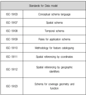
ISO/TC211 is an international standard organization which standards various fields of digital geographic information. In ISO/TC211, there are many standards about spatial data. Table 1 shows some ISO 19100 series standards about spatial data model.
CityGML is an XML-based spatial data model for the storage, management and transmission of Three-dimensional city model. This model is defined as OGC standard and registrated in ISO 19136.
Because CityGML uses XML grammar, it is based on file system [3][12].
Standards for Data model ISO 19103 Conceptual schema language
ISO 19107 Spatial schema
ISO 19108 Temporal schema
ISO 19109 Rules for application schema ISO 19110 Methodology for feature cataloguing ISO 19111 Spatial referencing by coordinates
ISO 19112 Spatial referencing by geographic identifiers
ISO 19123 Schema for coverage geometry and function
Table 1 Standards of ISO 19100 Series
One of the business spatial model is Shape File.
This model is the most widely used spatial data model which is open structure [2]. Shape File model also is based on file system. The model includes three types of files shp, dbf and shx. Shp file represents shape information of each geographic
feature objects and dbf file shows common attributes for feature objects. Shx file is an index file which is used to connect shp file and dbf file. This file structure is very similar to Digital Map 2.0 in Korea.
2. Spatial data model in Korea
In Korea, the Digital Map 2.0 is the most popular spatial data model which is an extension of Digital Map 1.0 [7]. This model consists of ngi file and nda file which represent shape information and common attributes like Shape File. Because Digital Map 2.0 source is inner format in NGII and not opened, Digital Map 2.0 model is used in a few GIS systems that hold the core technique about Digital Map 2.0.
Other GIS systems usually use Shape File whose data structure employs Digital Map 2.0 data structure. However, Digital Map 2.0 is used in many fields of GIS for example construction of 3D spatial data model [11].
Digital Map 2.0 uses tile-based management. The spatial data of Korea is too large to manage efficiently. The boundary of entire Korea is divided into several small tiles to avoid difficulty in large data. Each city or specify area is covered by some tiles. When there are some needs for spatial data of some city, it only use a few tiles that are covers the area.
Recently, to solve the problems of tile-based GIS systems, feature-based spatial data management system have been studied. Some spatial data models also have been proposed for feature-based spatial data management system [1].
One of the most popular research is Unique
Feature IDentifier(UFID) [1][4][5]. UFID is a code
which can only identify each geographic feature
object in spatial data model. For each system or
data model, they have their own UFID coding
system to manage their spatial data. Therefore,
UFID has a strong dependency with each system or
data model [7][8][9]. UFID has been researched in
many R&D enterprises. However UFID provide
system to manager spatial data by features, the file-based data model makes it can not effect in feature based management.
An other one is National Geographic Framework Database. National Geographic Framework Database is a database model that defines basic feature types which are commonly used in most GIS systems.
However it is a well designed data model that contains basic features in Korea, it can not represent various geographics in Korea. This model
also is too complex to apply in GIS systems. The almost data in National Geographic Framework Database data is made from Digital Map 2.0 data.
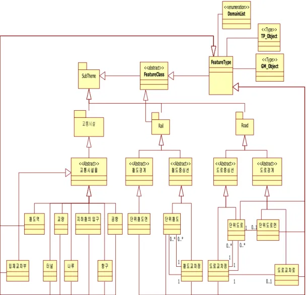
They apply transformation system to transform data into National Geographic Framework Database model. It lead to National Geographic Framework Database model is difficult to construct and management so that is not popular in GIS. Figure 1 shows data model for traffic group in National Geographic Framework Database.
SubTheme
FeatureClass
<<abstract>>
교통시설물
<<Abstract>>
철도경계
<<Abstract>>
철도중심선
<<Abstract>>
도로중심선
<<Abstract>>
도로경계
<<Abstract>>
FeatureType DomainList
<<enumeration>>
TP_Object
<<Type>>
GM_Object
<<Type>>
교통시설 Rail Road
철도역 교량 지하철의 입구
나루
입체교차부 터널 항구
공항 단위철도면 단위철도
단위도로 단위도로면
도로교차점 철도교차점
도로교차로 1 0..1
1 0..*
1 0..*
0..1 1
1 0..*
1 0..*
Fig. 1. Data Model for Traffic Group in National Geographic Framework Database
The features in this model are very different to Digital Map 2.0. For example, Crossroad feature
has different definitions in two data models. In National Geographic Framework Database, Crossroad feature is defined as the end nodes of the road segments which connect two road segments. In Digital Map 2.0, the Crossroad is the intersection of RoadChain objects. Therefore, the Crossroad have to be connected to more than three RoadChain objects in Digital Map 2.0. The road also has different representations. In National Geographic Framework Database, each Road object is represented by several line segments. It makes one Road feature is represented by several Road objects. In Digital Map 2.0, each Road feature is represented by one RoadChain features which are typed line string.
Ⅲ. DATA MODEL DESIGN
The spatial data model proposed in this paper is based classification and data structure of Digital Map 2.0. Figure 2 shows the design process of our data model. Design process consists of three parts - conceptual design, logical design and physical design. In this paper we describe only conceptual design which is the most important part in whole design process and skip logical design and physical design.
Fig. 2. Design Process for Feature-based Digital Map Data Model
1. Design for Conceptual Model
In conceptual design, we analyzed Digital Map
2.0 and decided the scope of feature and defined Theme, ClassGroup and Class. And then we designed the conceptual model and schema.
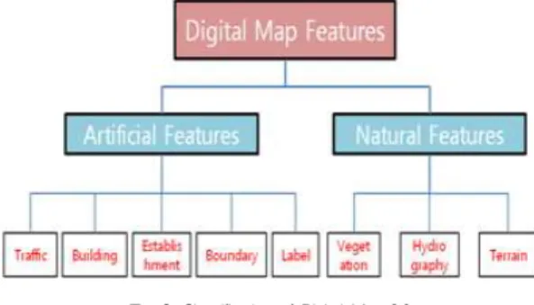
In this model, we applied data structure and classification of Digital Map 2.0. According to classification of Digital Map 2.0, in our model, all of spatial features are divided into artificial geographic feature and natural geographic feature.
Artificial Geographic Feature Theme consists of traffic, building, establishment, boundary and label ClassGroups and National Geographic Feature Theme consists of vegetation, hydrography and terrain ClassGroup. Each ClassGroup also consists of several feature Classes. The classification of Digital Map 2.0 is shown in Figure 3. This classification makes our model easy to construct and manage spatial features effectively.
Fig. 3. Classification of Digital Map 2.0
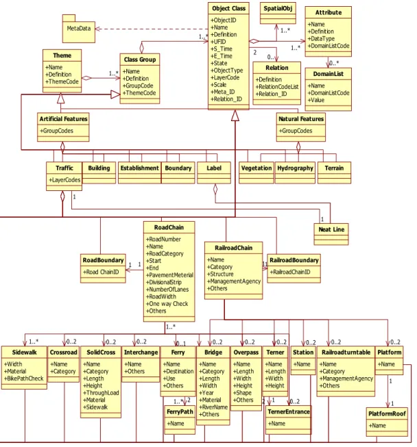
To define features is an important part in conceptual design of our Feature-based seamless data model. Our model employs the data structure of Digital Map 2.0. In Digital Map 2.0, it defines 130 geographic features and the most basic geographic features which can represent all spatial features in the Korea are 104. In our model, we removed some features which is not too small to display on the map. These features are grouped in 8 ClassGroups which have similar functions.
There are 18 features in traffic ClassGroup. The
features included in traffic ClassGroup have
various relationships and a lot of errors during
updating process. RoadChain feature and
RailroadChain feature are the main features in traffic ClassGroup. They have many relationships with other features to perform various functions.
Especially, positional relation is used to improve the accuracy of updated data. Figure 4 shows the
overall conceptual data model for traffic ClassGroup.
2. Define for Relation between Geographic Features
Theme +Name +Definition +ThemeCode
Class Group +Name +Definition +GroupCode +ThemeCode
Object Class +ObjectID +Name +Definition +UFID +S_Time +E_Time +State +ObjectType +LayerCode +Scale +Meta_ID +Relation_ID
SpatialObj
Relation +Definition +RelationCodeList +Relation_ID MetaData
2 0..
1..*
1..* 1..*
Traffic +LayerCodes Artificial Features +GroupCodes
Natural Features +GroupCodes
Building Establishment Boundary Label Vegetation Hydrography Terrain
RoadChain +RoadNumber +Name +RoadCategory +Start +End +PavementMeterial +DivisionalStrip +NumberOfLanes +RoadWidth +One way Check +Others RoadBoundary
+Road ChainID
RailroadChain +Name +Category +Structure +ManagementAgency +Others
RailroadBoundary +RailroadChainID
Sidewalk +Width +Material +BikePathCheck
Overpass +Name +Length +Width +Height +Shape +Others Bridge +Name +Category +Length +Width +Year +Material +RiverName +Others Crossroad
+Name +Category
SolidCross +Name +Category +Length +Height +ThroughLoad +Material +Sidewalk
Interchange +Name +Others
Terner +Name +Length +Width +Height
TernerEntrance +Name
Station +Name
Platform +Name
PlatformRoof +Name Railroadturntable +Name +Category +ManagementAgency +Others Ferry
+Name +Destination +Use +Others
FerryPath +Name
1..* 0..2 0..2 0..2 0..1
1..*
0..2 0..2 0..2
0..2 2 1
0..2 0..2 0..2
1..* 2 1
1 Attribute
+Name +Definition +DataType +DomainListCode 1..*
DomainList +Name +DomainListCode +Value
0..*
1 1 11
Neat Line 1 1
Fig. 4. Overall Conceptual Data Model for Traffic ClassGroup
Updating task is a process that old object is destroyed and new object is created. There are
many integrity errors in updating process. For example, when a new bridge object is inserted, this object should be on RoadChain object or RailroadChain object. For solving this problem, we construct various types of relationships. There are four types of relationships in the proposed model.
Inheritance
Some features inherit all characteristics from other feature. For example, RoadBoundary represents the boundary of RoadChain feature.
Therefore, the RoadBoundary feature has all attributes of RoadChain feature. RoadBoundary also has boundary information of RoadChain feature. To avoid duplicate data and integrity error, all the attribute values of RoadBoundary feature refer to attributes of RoadChain feature.
These relationship also can be used to check the updating errors. When a new RoadBoundary object is inserted, there have to be a RoadChain object which is represented by inserted RoadBoundary object. If a RoadChain object is modified or deleted the related RoadBoundary object also have to be modified or deleted simultaneously. Relationship between RoadBoundary and RoadChain is shown in Figure 5.
Fig. 5. Relationship between Road Boundary and RoadChain
Connection
This is the main type of relation in the proposed model. It shows many relations between each pair of features. For example, the Bridge and RoadChain has a positional relationship because
each Bridge object has to connect two RoadChain objects. If the Bridge object is not connected to any RoadChain object, the updated object might be an error data. Figure 6 shows an error insertion of Bridge object which is not connected to any RoadChain object.
Fig. 6. An error insertion of Bridge object
Confluence
There are some errors in updating process. We suppose that there are three RoadChain objects that are crossed by a Crossroad object. When a RoadChain object connected to two of other RoadChain objects is deleted, there are only two RoadChain objects connected to the Crossroad object. Because a Crossroad object has to connected to more than three RoadChain objects, in this case, the Crossroad object should be deleted simult- eously.
Ⅳ. MODEL ANALYSIS
To analyze the applicability of proposed spatial data model in real environment, we choose some important functional elements to get logical tests.
1. Seamless expression for a feature
The feature-based seamless Digital Map 2.0
model proposed in this paper uses UFID to identify
each logical features. Every geographic feature in
real world has their unique code. We use this code to search each logical feature from database.
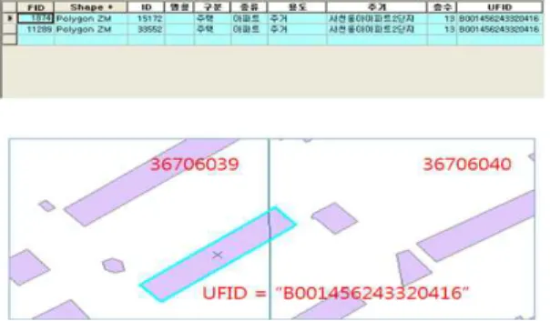
Suppose there is a building named "43 Dong, Chungbuk National University" and it's UFID code is "B00145624 320416". This code was assigned when the "43 Dong, Chungbuk National University"
object is inserted. If a user wants to search this building from database, we can use following query shown in Figure 7.
Fig. 7. Query example for searching seamless object using UFID
After executing query, the system returns the following result shown in Figure 8. There are two feature objects in the result. Because the building object is cut into two different tiles which are
"36706039" and "36706040", the building object is divided into two physical features and stored in database. However, we assign a same UFID code to physical features to show it is one logical feature object.
Fig. 8. Result for searching seamless object using UFID
2. Error checking in real time update
Checking errors from updated data is an
important but a very difficult task in real time update process. For most spatial management systems which use current data model, all the error checking tasks are performed manually. Proposed model supports system can check some logical error automatically. To test the process of error checking, we consider an updating case.
Fig. 9. Deletion of Crossroad by automatical error checking.
Suppose there is a Crossroad object which is connected to three RoadChain objects whose serial numbers are 1, 2 and 3. A RoadChain object which number is 3 is deleted by deletion operation. The system would delete RoadChain object from database and then count the number of RoadChain objects connected to Crossroad object from relation of the data model. There are only two RoadChain objects connected to Crossroad object. Since one Crossroad object have to be connected to more than three RoadChain objects, the system would automatically delete the Crossroad object from database simultaneity shown in Figure 9.
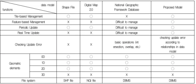
3. Compare with current data models
We compared proposed model with other main
spatial data models such as Shap File, GML and
Digital Map 2.0. The comparison of characteristics
of each spatial data model is shown in Table 2. All
data models use tile-based management system
except the National Geographic Framework
Database and proposed model. The file-based
models can not support real time update since all
the file should be constructed again when a feature
object is updated. Proposed data model is designed
for feature-based management. To manage each feature directly, we use a relational database model. Therefore, proposed model can support any
real time update by accessing each feature objects directly.
data model
functions Shape File Digital Map
2.0
National Geographic
Framework Database Proposed Model
Tile-based Management 〇 〇 ☓ 〇
Feature-based Management ☓ ☓ Difficult to manage 〇
Periodic Update 〇 〇 Difficult to manage 〇
Real Time Update ☓ ☓ Difficult to manage 〇
Checking Update Error ☓ ☓ basic operations (int
ersection, overlap, etc.)
checking update error according to relationships in data
model
Geometric elements
0D 〇 〇 〇 〇
1D 〇 〇 〇 〇
2D 〇 〇 〇 〇
3D ☓ ☓ ☓ ☓
File system SHP file NGI file DBMS DBMS
Table 2. Comparison of characteristics for each spatial data model
Because the National Geographic Framework Database is based on DBMS, it also can access each object directly. However, the definition of the feature is not based on logical spatial features, it is difficult to support feature-based management system. An other one problem in National Geographic Framework Database is that the construction is based on Digital Map 2.0 data. It lead update process more difficult.
Ⅴ. CONCLUSION
Recently, with increase of a demand on the spatial data, user hopes more accurate and active spatial data. Therefore, the tile-based Digital Map management system can not satisfy user's requirement. Feature-based management system can store and manage each specific features easily.
However, current spatial data model is not suitable to feature-based management systems.
To solve this problem, we propose a
feature-based seamless data model using Digital Map 2.0. Because the proposed model used Digital Map 2.0 structure which is the mainly used model in Korea, this model can apply to any current management system easily and the data is easy to get from other systems. In this paper, we analyzed the applicability of the proposed data model and compared with other models. The proposed model can be applied to various spatial data management systems to show it's ability.
REFERENCES
[1] J.H. Chi, S.K. Kim, K.H. Ryu, M.J. Kim,
"Design of a Feature-based Spatial Data Management System for Digital Map," The Journal of GIS Association of Korea, vol. 7, no.
3, pp. 107-118, 2005.
[2] ESRI, "ESRI Shapefile Technical Description,"
ESRI, 1998.
[3] ISO/TC 211, "ISO-CD 19136 Geographic Information Geography Markup Language,"
ISO/TC 211, 2007.
[4] H.S. Kim, S.Y. Kim, Y.K. Lee, S.B. Seo, K.S.
Park, K.H. Ryu, "Spatial Data Model of Feature-based Digital Map using UFID,"
Journal of Korea Spatial Information System Society, vol. 11, no.1, pp. 71-78, 2009a.
[5] H.S. Kim, S.Y. Kim, Y.K. Lee, J.W. Lee, C.
Park, K.H. Ryu, "UFID-based Spatial Data Model for Digital Map," Korea Information Processing Society, 16(1): 401-402, 2009.
[6] H.S. Kim, S.Y. Kim, S.B. Seo, K.H. Ryu,
"Feature-Based Spatial data Modeling for Seamless Map, History Management and Real-time Updating," International Symposium on Remote Sensing 2008, 2008a.
[7] S.Y. Kim, H.S. Kim, S.B. Seo, K.H. Ryu,
"Spatial Data Modeling for Feature-based Efficient Updating and History Management,"
Korea Information Processing Society, 15(2):
352-355, 2008b.
[8] NGII, "A Study on The Digital Map Data Model I," NGII, 1998.
[9] NGII, "A Study on The Digital Map Data Model II," NGII, 1999.
[10] NGII, "A Study on Manufacture of The CleanData Digital Map," NGII, 2000.
[11] S.J. Oh, I.P. Lee, S.J. Kim, K.A. Choi,
"Generation of a City Spatial Model using a Digital Map and Draft Maps for a 3D Noise Map," Korean Journal of Remote Sensing, vol.
24, no. 2, 179-188, 2008.
[12] Open Geospatial Consortium(OGC), "OpenGIS Geography Markup Language Encoding Standard,"
Open Geospatial Consortium(OGC), 2007.
[13] S.H. Park and J.Y. Lee, "Comparative Analysis of 3D Spatial Data Models," The Journal of GIS Association of Korea, vol. 17, no. 3, pp. 227-285, 2009.
저 자 소 개