1. Introduction
The near-surface air temperature (Ta), that was defined as temperature of 2m above from the ground of meteorological stations, is one of useful variables in
various research fields such as meteorology, climatology, and hydrology (e.g. Wenbin et al., 2013).
Ta is conventionally observed at meteorological stations with high accuracy (Stisen et al., 2007), but these point data cannot consider variation by space
Accuracy evaluation of near-surface air temperature from ERA-Interim reanalysis and satellite-based
data according to elevation
Jae-Hyun Ryu, Kyung-Soo Han
†and Eun-Bin Park
Department of Spatial Information Engineering, Pukyong National University
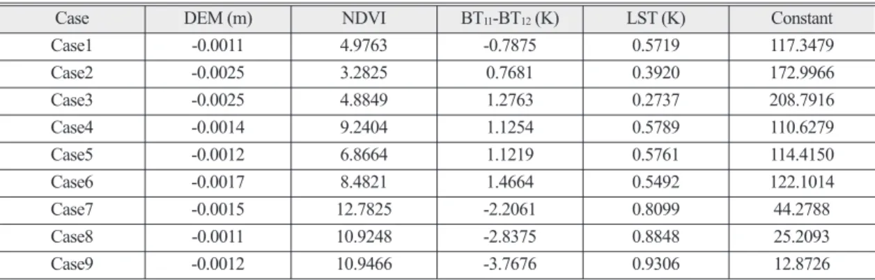
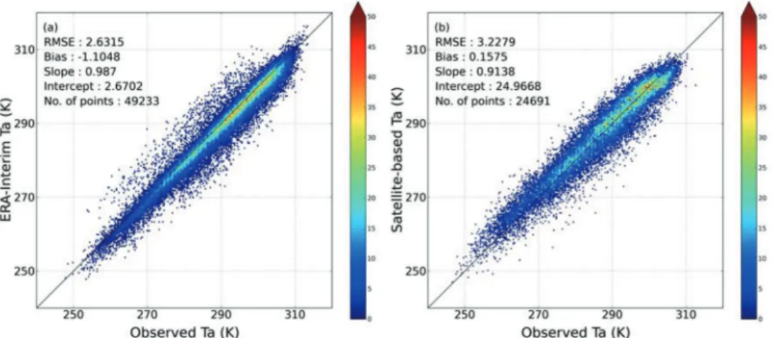
Abstract : In order to spatially interpolate the near-surface temperature (Ta) values, satellite and reanalysis methods were used from previous studies. Accuracy of reanalysis Ta was generally better than that of satellite- based Ta, but spatial resolution of reanalysis Ta was large to use at local scale studies. Our purpose is to evaluate accuracy of reanalysis Ta and satellite-based Ta according to elevation from April 2011 to March 2012 in Northeast Asia that includes various topographic features. In this study, we used reanalysis data that is ERA- Interim produced by European Centre for Medium-Range Weather Forecasts (ECMWF), and estimated satellite-based Ta using Digital Elevation Meter (DEM), Normalized Difference Vegetation Index (NDVI), difference between brightness temperature of 11 μm and 12μm, and Land Surface Temperature (LST) data.
The DEM data was used as auxiliary data, and observed Ta at 470 meteorological stations was used in order to evaluate accuracy. We confirmed that the accuracy of satellite-based Ta was less accurate than that of ERA- Interim Ta for total data. Results of analyzing according to elevation that was divided nine cases, ERA-Interim Ta showed higher accurate than satellite-based Ta at the low elevation (less than 500 m). However, satellite- based Ta was more accurate than ERA-Interim Ta at the higher elevation from 500 to 3500 m. Also, the width of the upper and lower quartile appeared largely from 2500 to 3500 m. It is clear from these results that ERA- Interim Ta do not consider elevation because of large spatial resolution. Therefore, satellite-based Ta was more effective than ERA-Interim Ta in the regions that is range from 500 m to 3500 m, and satellite-based Ta was recommended at a region of above 2500 m.
Key Words : near-surface air temperature, ERA-Interim, elevation
Received October 18, 2013; Revised November 8, 2013; Accepted November 20, 2013.
†