한국정보통신학회논문지 Vol. 23, No. 6: 637~644, Jun. 2019
공간 정보 질의를 이용한 차량 추적 애플리케이션의 설계 및 구현
아누그라 모흐 일함1·정진욱2·진교홍3·황민태4*
Design and Implementation of The Vehicle Tracking Applications using Geospatial Query
Anugrah Moch Ilham 1 · Jin-uk Jung 2 · Kyo-Hong Jin 3 · Min-Tae Hwang 4*
1
Graduate Student, Department of Eco-Friendly Offshore Plant FEED Engineering, Changwon National University, Changwon, 51140 Korea
2
Lecturer, Department of Electronic Engineering, Changwon National University, Changwon, 51140, Korea
3
Professor, Department of Electronic Engineering, Changwon National University, Changwon, 51140 Korea
4*
Professor, Department of Information & Communication Engineering, Changwon National University, Changwon, 51140 Korea
요 약
공공 안전은 스마트 시티(Smart City)의 주요 목표 중 하나이다. 본 논문에서는 공공 안전에 도움을 줄 수 있는 차 량 추적 시스템을 제안하고서 관련 애플리케이션을 설계 및 구현하였다. 제안하는 차량 추적 시스템의 목적은 경찰 에게 도난 차량의 위치 정보를 실시간으로 제공해서 보다 효율적으로 도난 차량을 추적하는 것이다. 차량 소유자가 차량 추적을 요청하면, 이 요청을 수신한 공공 안전 서버 프로그램은 공간 정보 질의(Geospatial Query) 기법을 사용 하여 도난 차량과 가장 가까운 경찰을 찾아 도난 차량의 위치와 시간, 거리 및 경로와 같은 정보들을 제공한다. 구현 한 시스템의 유효성을 입증하기 위해 타임 스탬프(Time Stamp)를 이용한 트랜잭션 시뮬레이션을 수행하였으며, 이 시뮬레이션을 통해 1.2초 이내의 빠른 시간 내에 차량 소유자의 요청이 경찰에게 전달되는 것을 확인할 수 있었다.
ABSTRACT
In recent years, many public safety systems in the smart city are developed. These systems are taking responsibility to make a safe and comfortable city. In this paper, we propose vehicle tracking systems include a public safety system that enables the policeman to track the stolen vehicles more efficiently by providing the vehicle information in real time.
When a vehicle is stolen, the vehicle owner can send a user emergency request. Then, the public safety server which supported by a geospatial query technique will give information such as time, distance, and routes to a policeman who is closest to the location of the vehicle to catch the thief. 300 simulations were performed to evaluate the performance of the system. We found that the average of times required when vehicle owner send a user emergency message on user application until policeman obtain a vehicle tracking request on police application below 1.2 seconds.
키워드
: 공간 정보 질의, 공공 안전, 스마트 시티, 차량 추적 시스템
Key word
: Geospatial Query, Public Safety, Smart City, Vehicle Tracking System
Received 8 May 2019, Revised 18 May 2019, Accepted 20 May 2019
* Corresponding Author Hwang Mintae (E-mail:[email protected], Tel:+82-55-213-3839)
Professor, Department of Information and Computer Engineering, Changwon National University, Changwon 51140, Korea
Open Access http://doi.org/10.6109/jkiice.2019.23.6.637
print ISSN: 2234-4772 online ISSN: 2288-4165Ⅰ. Introduction
A Smart city is a future city combining the existing city with ICT technologies to solve a city's problems and utilize efficiently resources of various kinds. Recently, many countries have been working on building smart cities suitable for their cities[1].
On “Movement to 100 Smart City” program, Indonesia has planned to achieve 100 smart cities in 2019[2]. Until 2018, there are already 74 cities that implemented smart city[3]. One of the cities is Bandung, the target to be achieved by Bandung government is to implement a smart living for making a safe, comfortable, productive, and sustainable city[4].
The typical smart living program of Bandung is Bandung Command Center (BCC). This program has SOS request service, named as X-IGENT Panic Button[5], This service is a mobile application which aims to help the citizen to send emergency messages when they are in a dangerous situation to BCC. Then the SOS request will be immediately handled by BCC officer.
Even though Panic Button Service is used, according to the head of police department in 2018, the crime rates in Bandung was the highest in West Java province in the part of vehicle theft, specifically[6]. The Panic Button service is very helpful for citizens under dangerous situation. However, This is not enough to catch the thief and reduce crime rates in Bandung.
In order to prevent the vehicle-theft, commercial anti-theft systems or vehicle tracking systems can be used. When a vehicle is stolen, a vehicle owner can know his vehicle location using a mobile application. In this case, the owner should not try to get back his vehicle himself. Instead of that, the vehicle owner have to call the police department and report where the vehicle is located. However, these processes are not efficient.
Because the stolen vehicle can move quickly, so the police department cannot track the current location of the stolen vehicle in real-time.
To solve these problems, we developed a vehicle
tracking systems that enables the police to track the stolen vehicles more efficiently by providing vehicle information stored in existing commercial anti-theft systems to the police. The developed systems consist of two systems, the commercial anti-theft system and the public safety system. The commercial anti-theft system collects the vehicle information periodically. If the system receives SOS request message from a vehicle owner, the system will share vehicle information and vehicle owner data with the public safety system. The public safety system store and analyzes the shared data to provide information such as distance, time and routes for a policeman who is closest to the stolen vehicle using geospatial query technique.
This paper is organized as follows. Section II introduces related works with this research. In section III proposed the vehicle tracking system. Section IV introduces the vehicle tracking applications and gives a short test on system performance. Finally, the conclusion and future works that can be implemented in the system follows in section V.
Ⅱ. Related Works
In this section, we present the most relevant work with the systems proposed.
2.1. Public safety service in smart-city
Mendoca et al. present ROTA, a smart city platform to improve public safety in Natal city, Brazil. ROTA consist of two modules. The first module is the Patrol Vehicle Module (ROTA-PVM), by using this the patrol officer can receive notifications about new incidents from the control room, along with driving directions and historical information for proper situational awareness.
The second module is a web dashboard allows to analyze
the trajectory of all patrol vehicles and assist patrol
decisions[7]. IBM also developed a smart city platform,
IBM Intelligent Operations Center (IBM-OC), to provide
situation awareness and report to respective agencies[8].
Ericson et al. introduce Next-Generation Incident Command System (NICS) which support to request resources in case of criminal activity, personal injury, or fire ranked highly[9]. Another research is safety map application[10]. A map application which allow the local residents to directly upload and share information on local issues. The public safety systems that have been explained does not focus on vehicle-related crime.
Therefore, we proposed a system which aims to improve the public safety system, especially in handling vehicle theft.
2.2. Anti-theft system
Generally, the anti-theft or vehicle tracking system consists of three major parts, a tracking device, anti-theft server, and user application. The tracking device mostly has a Global Position System(GPS) and communication module such as GSM or 4G LTE [11-17]. GPS is used to get vehicle location data and communication modules are used to send the data to the anti-theft server to provide a vehicle monitoring service for the vehicle owner. Mutiawani et al. introduce a vehicle tracking system using mobile application which has a role to be a tracking device. When the distance between vehicle and owner is more than the distance set by the owner, a alarm will send to user application[18]. Many of these researches focus on the hardware part. And when the vehicle is stolen, the vehicle location only stored in the anti-theft server.
2.3. Services with geospatial query
UBER, GOJEK, and GRAB are public transportation sharing system that uses geospatial data in their main services[19]. Geospatial query is specialized types of SQL queries which use spatial data. By using geospatial query, the systems can find the distance between two points and show the number of objects around the specific location [20]. In these systems, there are mobile applications for driver and costumer. When the customer requests for driver, by using geospatial query the main server will find the available driver which is closest to
the customers location. Then, the server will send a request to the driver to go to the costumers location.
From related research that has been explained, if the vehicle is stolen, the vehicle location data only stored in the anti-theft server. So the police department has a difficulty to track the stolen vehicle. Therefore, in this paper, we focused on how the vehicle location data can be more useful on the government side. And using the geospatial query, the proposed system can determine and provide information to the policeman who is closest to the stolen vehicle.
Ⅲ. The Proposed Vehicle Tracking System
Fig. 1 shows the block diagram of the proposed vehicle tracking system. This system consists of a tracking device, a user application, a commercial anti- theft server, a public safety server, and a police application.
Fig. 1 The block diagram of the proposed vehicle tracking
systemThe proposed vehicle tracking systems operate as
follows. First, a tracking device installed in the vehicle
periodically transmits VIM(Vehicle Information Message),
the message containing data related to the ehicle, to
anti-theft server program operating on the anti-theft
server. The program stores vehicle location data in the
message into the anti-theft database. The vehicle owner
can request SOS service when the vehicle is stolen. In
this case, a UEM(User Emergency Message) will be sent
to the anti-theft server program. The anti-theft server program combines the received user emergency message with the owner's vehicle location data to create a VTRM(Vehicle Theft Report Message) and sends it to public safety server program. The public safety server program searches a policeman who is closest to the stolen vehicle. Then, the program delivers a VTRM (Vehicle Tracking Request Message) to the police application to help the policeman for tracking the stolen vehicle. Besides, the vehicle owner can monitor the location of the vehicle using a user application that displays the vehicle location data stored on the anti-theft server database.
3.1. Tracking Device
The tracking device is installed on the vehicle. This device has two roles. The first is to acquire vehicle location data using the GPS module. The second is to periodically transmit the vehicle information messages which consist of time, latitude, longitude, and serial number of tracking device to the anti-theft server program. For these, this device must include a GPS module and 3G/4G/LTE module because it is to necessary to be able to obtain the location data of the vehicle and transmit the data to the anti-theft server anywhere at any time.
3.2. Anti-theft server
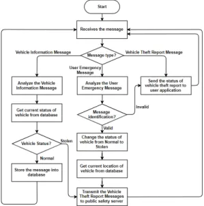
In the anti-theft server, the anti theft server program and database is running. Fig.2 represents flowchart of the anti-theft server program. The anti-theft server program is always operating to processes three messages. Vehicle information message, user emergency message, and vehicle theft report message.
If vehicle owner send a user emergency message to this program, the program will identify the message.
When the message identification is successfully validated, the program will change the status of the vehicle from Normal to Stolen and obtain the current location of the vehicle from anti-theft database. The program will generate a vehicle theft report messages
and transmit to public safety server. If the vehicle information messages sent by tracking device is received, in addition because the status of vehicle is changed to the stolen, the vehicle information messages also will transmitted to public safety server before stored in the anti-theft database. Finally, the anti-theft server program will send the user emergency status to user application when receive a vehicle theft report from public safety service.
Fig. 2 Flowchart of vehicle location data processing
programTo store the information related to the operation on
the anti-theft server, there are three tables as shown in
Fig. 3. Named vehicle_information, vehicle_owner, and
vehicle_theft_report. The vehicle_information table
contains vehicle information messages sent by tracking
device. This table is required to display the location of
vehicle through the user application according to the
serial number. Information related to the vehicle owner
stored in vehicle_owner table. If the vehicle owner uses
the SOS request service in the user application, then a
user emergency message is generated and stored in the
vehicle_theft_report table.
Fig. 3 The three tables in anti-theft database
3.3. Public safety server
The proposed public safety server in this system has to provide NoSQL database to support geospatial query technique. This server has two main roles. First is to store the data sent by anti-theft server and police application into public safety database. Second is to process the vehicle theft report message.
Fig. 4 describes the flowchart of the public safety server program. When a VTRM received, the program will analyze the message to find the policeman who is closest to the location of the stolen vehicle with radius one-kilometer from the location of the stolen vehicle. If the program can not find a policeman, the distance of radius to find policeman will be increased by one kilometer every increment. Finally, if the program finds a policeman, the program sends the vehicle tracking request message to police application including routes, time, distance, and address of the stolen vehicle.
There are four tables in the public safety database.
Named police_location, police_info, stolen_vehicle, and vehicle_theft_report. The relational tables showed by Fig. 5. The police_location table contains information of police location sent by police application. When the public safety server receives a VTRM, the data in this table is used to determine policeman who is closest to the location of stolen vehicle. In the police_info table, contains a list of all the policeman which are using police application. The VTRM stored by public safety server in the SOS request table, these data will be used for another public safety service in the future.
On the design of anti-theft and public safety databases there are foreign keys. These keys is only an optional
when applied to databases. We only use it to show relationships between tables.
Fig. 4 Flowchart of public safety server program
Fig. 5 The four tables in public safety database
Ⅳ. Implementation of Vehicle Tracking Applications
The applications built for this system are Android-based application. Besides, most of the smartphone users in Indonesia are using Android operating system[21], the smartphone also has been installed with a GPS module to determine where the users are located. And google firebase as public safety server to support the public safety server program.
4.1. User Application
A vehicle owner can check his vehicle’s location in real time using the user application. We use Google Map to display local map and Google place API to obtain information about places around the vehicle. In addition, when the vehicle is stolen, the owner can request a policeman to track the vehicle by pressing the SOS button. At this time, User Emergency Message is sent to the anti-theft server. Fig. 6 shows the screenshots for vehicle monitoring and SOS request activity in the user application.
(a) (b)
Fig. 6 The screenshots for the vehicle monitoring(a)
and SOS request activity(b) in the user application4.2. Police Application
After receiving Vehicle Tracking Request Message, the police application will shows the stolen vehicle information such as location, distance and travel time on
the map as shown in Fig. 7(a). When the policeman accepts the request, the police application will provide a route from the policeman location to the stolen vehicle as shown in Fig. 7(b). Then, the police application will send VTAM(Vehicle Tracking Acceptance Message) to public safety server.
(a) (b)
Fig. 7 The screenshots in the police application when
receiving Vehicle Tracking Request Message(a) and tracking a stolen vehicle activity(b)4.3. Performance Evaluation
The purpose of the developed systems is to ensure that the policeman responds quickly to the vehicle owner’s request. Therefore, we measured the time between when the vehicle owner sends the User Emergency Message until the policeman receives the request on the police application.
To prove the performance, 300 simulations which are
divided into five experimental cases was performed. For
each case, we assumed the distance between policeman
who receiving the vehicle theft request and the stolen
vehicle is increased by 1 km. Fig. 8 shows the required
average time is getting higher when the distance between
a policeman and the stolen vehicle is increasing. These
results are obtained because the policeman searching
algorithm start finds the policeman within a radius of 1
km. If there is no policeman founded, the searching
radius will be added 1 km until the maximum radius is 5
km. Finally, we found the average required times below
1.2 seconds. It was a short time to provide information to help a policeman to catch the thief when compared to the conservative method.
Fig. 8 The average time required to send a User
Emergency MessageⅤ. Conclusion and Future Research
In this paper, we introduce a vehicle tracking system that enables the policeman to track the stolen vehicles more efficiently by providing vehicle information stored in existing commercial anti-theft systems. According to the simulations, the required average time when the vehicle owner sends the User Emergency Message until the policeman receives the message on the police application below 1.2 seconds. Through this system, the vehicle owner and police department can reduce several unnecessary processes when a vehicle is stolen. We expect our proposed system will be helpful for the policeman to take action quickly to catch the thief.
In the future, we will use the collected data for another public safety service such as provide crime- prone zone and crime mapping information to support the smart city.
ACKNOWLEDGEMENT
This research was supported by Changwon National University in 2019-2020.
REFERENCES
[ 1 ] J. Jiong, J. Gubbi, S. Marusic, and M. Palaniswarni. (2014, January). An Information Framework for Creating a Smart City Through Internet of Things. IEEE Internet of Things
Journal [Online]. 01(02), pp. 112-121. Available :
https://ieeexplore.ieee.org/stamp/stamp.jsp?tp=&arnumber=6702523.
[ 2 ] Republika. Ministry launches 100 smart city movement [Internet]. Available: https://www.republika.co.id/berita/
en/%20national-politics/17/05/22/oqd3xr414-ministry-laun ches-100-smart-city-movement.
[ 3 ] Ministry of Communication and Information Technology.
Gerakan menuju 100 smart city [Internet]. Available:
https://aptika.kominfo.go.id/2018/11/gerakan-menuju-100- smart-city.
[ 4 ] Bandung Government. Masterplan bandung smart city [Internet]. Available: https://smartcity.bandung.go.id/smartcity /eksternal/show/130.
[ 5 ] Bandung Command Center. Panic Button [Internet].
Available: https://commandcenter.bandung.go.id/layanan/
panic-button
[ 6 ] Jawa Pos Multimedia. 2018 Tingkat kriminalitas Bandung tertinggi di Jawa Barat [Internet]. Available: https://www.
jawapos.com/jpg-today/28/12/2018/sepanjang-2018-tingkat -kriminalitas-bandung-tertinggi-di-jawa-barat.
[ 7 ] M. Mendoca, B. Moreira, J. Coelho, N. Cacho, F. Lopes, E.
Cavalcante, A. Dias, J . Ribeiro, E. Loiola, D. Estaregue, and B. Moura. (2016, October). Improving public safety at fingertips: A smart city experience. IEEE International
Smart Cities Conference [Online]. Available: https://ieeexplore.
ieee.org/stamp/stamp.jsp?tp=&arnumber=7580772.
[ 8 ] IBM. IBM Intelegent Operation Center [Internet]. Available:
https://www.ibm.com/us-en/marketplace/city-insights.
[ 9 ] P. Erickson, A. Weinert, P. Breimyer, M. Samperi, J. Huff, C. Parra, and S. Miller, “Designing public safety mobile applications for disconnected, interrupted, and low bandwidth communication environments,” in Proceedings
of the 2013 IEEE International Conference on Technologies for Homeland Security. USA: IEEE, pp. 790
–796, 2013.[10] S. D. Park, “Development of Safety Map Application for Local Residents,” Journal of The Korea Institute of
Information and Communication Engineering, vol. 23, no.
3, pp. 229-304, Jan. 2019.
[11] M. F. Saaid, M. A. Kamaludin, and M. S. Ali, “Vehicle location finder using Global position system and Global System for Mobile,” in Proceeding of the 5th
IEEE Control
and System Graduate Research Colloquium, Malaysia, pp.
279-284, 2014.
[12] K. Mukherjee. (2014, December). Anti-theft vehicle tracking and immobilization system. International Conference on
Power, Control and Embedded Systems (ICPCES) [Online].
Available: https://ieeexplore.ieee.org/stamp/stamp.jsp?tp=
&arnumber=7062814.
[13] K. A. Mamun, and Z. Ashraf. (2016, May). Anti-theft vehicle security system with preventive action. 2nd Asia-Pacific
World Congress on Computer Science and Engineering (APWC on CSE) [Online]. pp. 1
–6. Available: https://ieeexplore.ieee.org/stamp/stamp.jsp?tp=&arnumber= 7476241.
[14] A. Wu. (2017, November). The design of anti-theft device for vehicle based on GSM. International Conference on
Smart Grid and Electrical Automation (ICSGEA) [Online].
pp. 384–386. Available: https://ieeexplore.ieee.org/stamp/
stamp.jsp?tp=&arnumber=8104408.
[15] B. K. Park, H.R. Choi, C.S. Kim, K.B. Lee, and M.S. Park,
“Development of Simulation System for Real-Time Location Tracking in Global Shipping Logistic,” Journal of
The Korea Institute of Information and Communication Engineering, vol. 19, no. 5, pp. 1235-1242, May. 2015.
[16] J.S. Lee, M.H. Jeon, K.W. Cho, and C.H. Oh, “Traffic Information Extraction and Application When Utilizing Vehicle GPS Information,” Journal of The Korea Institute of
Information and Communication Engineering, vol. 17, no.
12, pp. 2960-2965, Dec. 2013.
[17] Z. Liu, A. Zhang, and S. Li, “Vehicle anti-theft tracking system based on Internet of things,” in Proceedings of the
IEEE International Conference on Vehicular Electronics and Safety, China, pp. 48
–52, 2013.[18] M. Viska, S. Rahmany, and T. F. Abidin. (2018, September).
Anti-theft vehicle monitoring and tracking android application using firebase as web service. International
Conference on Electrical Engineering and Informatics
[Online]. pp. 72-77. Available: https://ieeexplore.ieee.org/stamp/stamp.jsp?tp=&arnumber =8548842.
[19] Suhag, Ravi. ATLAS: GO-JEK’s real-time geospatial visualization platform [Internet]. Available: https://blog.
gojekengineering.com/atlas-go-jeks-real-time-geospatial-vi sualization-platform-1cf5e16814c5.
[20] MongoDB Inc, Geospatial Query [Internet]. Available:
https://docs.mongodb.com/manual/tutorial/geospatial-tutori al/#overview.
[21] StatCounter. Mobile Operating System Market Share Indonesia [Internet]. Available: http://gs.statcounter.com/
os-market-share/mobile/indonesia.
아누그라 모흐 일함 (Anugrah Moch Ilham)
2017 인도네시아 파순단대학교 정보공학과 공학사 2017 ~ 현재 창원대학교 친환경해양플랜트
FEED공학전공 석사과정
※ 관심분야 : 안드로이드 응용, 사물인터넷 응용 기술
정진욱(Jin-uk Jung)
2004 동의대학교 멀티미디어공학과 공학사 2006 동의대학교 디지털미디어공학과 공학석사 2012 창원대학교 전자공학과 공학박사
※ 관심분야 : 사물인터넷, 스마트 그리드, 컴퓨터프로그래밍, 데이터통신 및 컴퓨터네트워크
진교홍(Kyo-hong Jin)
1991 부산대학교 컴퓨터공학과 공학사 1993 부산대학교 컴퓨터공학과 공학석사 1997 부산대학교 컴퓨터공학과 공학박사 1997 ~ 2000 국방과학연구소 선임연구원 2000 ~ 2004 동의대학교 멀티미디어공학과
조교수
2004 ~ 현재 창원대학교 전자공학과 교수
※ 관심분야 : 데이터통신, 센서네트워크, 유비쿼터스 컴퓨팅, 스마트 팩토리, 사물인터넷
황민태(Mintae Hwang)
1990 부산대학교 컴퓨터공학과 공학사 1992 부산대학교 컴퓨터공학과 공학석사 1996 부산대학교 컴퓨터공학과 공학박사 1996 ~ 1998 한국전자통신연구원 표준연구센터
선임연구원
1999 인제대학교 정보컴퓨터공학부 교수 2000 ~ 현재 창원대학교 정보통신공학과 교수
※ 관심분야 : 통신 프로토콜, 안드로이드 응용, 사물인터넷, 경량암호화, 스마트시티