Korean J. Mineral. Petrol. Vol. 33, No. 3, p. 175~183, 2020 https://doi.org/10.22807/KJMP.2020.33.3.175
강릉-동해 연안 퇴적물의 점토광물에 관한 연구
구효진1·최헌수2·조현구1*
1경상대학교 지질과학과 및 기초과학연구소, 2한국지질자원연구원 석유해저연구본부
Clay Mineralogy of the Gangneung-Donghae Coastal Sediments
Hyo Jin Koo1, Hunsoo Choi2, and Hyen Goo Cho1*
1Department of Geology and Environmental Sciences and Research Institute of Natural Science, Gyeongsang National University, Jinju 52828, Korea
2Petroleum and Marine Research Division, Korea Institute of Geoscience and Mineral Resources, Daejeon 34132, Korea
요 약: 한반도 3개 해역 중 동해 퇴적물의 점토광물에 관한 연구는 고환경 변화 측면에서의 일부 연구 외 에는 거의 이루어진 바가 없다. 이번 연구에서는 2017년부터 2019년까지 강릉-동해 해역에서 상자형 시료채 취기를 이용하여 채취한 120개 퇴적물 시료에 대한 점토광물 특성과 분포 상태를 바탕으로 기원지를 추정하 였다. 점토광물 함량은 일라이트, 녹니석, 카올리나이트, 스멕타이트 순으로 풍부하다. 수심 150 m 이하의 대 륙붕 퇴적물은 대륙사면 퇴적물에 비하여 녹니석과 카올리나이트 함량은 많고 일라이트 결정도는 좋은데 반 하여 일라이트와 스멕타이트 함량과 S/I 지수는 작다. 대륙붕 퇴적물의 경우 강릉 쪽은 녹니석 함량이 많고, 동해 쪽은 카올리나이트 함량이 많은데 이것은 육상 지질을 반영한 것으로 여겨진다. 이와 같은 점토광물의 여러 특징은 대륙붕 퇴적물과 대륙사면 퇴적물의 기원지가 다른 것을 시사한다. 대륙붕 퇴적물은 주변 하천 을 통하여 유입되었고, 대륙사면 퇴적물은 해류에 의하여 남쪽으로부터 이동된 것으로 판단된다.
핵심어: 동해, 퇴적물, 점토광물, 대륙붕, 대륙사면, 기원지
Abstract:
There have rarely been performed for the clay mineralogy of the East Sea sediments except for few studies about paleoenvironmental aspect. This study inferred the provenance of sediments based on the clay mineral characteristics and distribution pattern for the 120 sediment samples collected by the box corer from the Gangneung-Donghae area between 2017-2019. The relative proportions of the four major clay minerals are abundant in the order of illite, chlorite, kaolinite, and smectite. The continental shelf sediments below water depth 150 m have more chlorite and kaolinite content and better illite crystallinity, but less illite and smectite content, and S/I index than those of continental slope sediments. Clay mineral composition of the continental shelf sediments are influenced by the adjacent continental geology, because north site (Gangneung area) has more chlorite but south site (Donghae area) has more kaolinite. These characteristics and distribution pattern of clay minerals indicate that the provenance of sediments are different between continental shelf and continental slop. The continental shelf sediments may be introduced the study area by the adjacent small rivers whereas the continental slope sediment might be supplied by current from the south of the study area.Keywords:
East Sea, sediment, clay mineral, continental shelf, continental slope, provenance*Corresponding author Tel: +82-55-772-1474 E-mail: [email protected]
176 구효진 · 최헌수 · 조현구
서 론
삼면이 바다로 둘러싸인 한반도에서 동해는 서해나 남해와 다른 특성을 가지고 있다. 서해와 남해는 경 사가 완만한 대륙붕 지형으로 이루어져 있는데 반해 동해는 대륙붕의 발달이 미약하며 해안에서부터 대륙 붕, 대륙사면 및 심해분지로 급격한 지형 변화를 나 타내고 있다(Chough, 1983; Yun et al., 2015). 동해 의 대륙붕은 황해와 남해에 비하여 상대적으로 좁고, 경사도는 심하다. 동해 대륙붕의 평균경사도는 0.6도 이고 붕단이 나타나는 깊이는 해안에서 18-25 km 떨어진 수심 143 m이다(The Geological Society of Korea, 1999). 특히 연구 해역 부근인 양양-삼척 사 이의 대륙붕은 폭이 20 km 이하이며, 대륙사면은 2-8 도의 급한 경사를 가진다(Yun et al., 1996; Park et al., 1997).
지표면(지표로부터 깊이 20km 이내)의 75%는 퇴 적암이며, 점토광물은 이들 퇴적암의 약 40%를 차지 하여 지구표면의 약 23%를 구성하는 것으로 알려져 있다. 또한, 해양퇴적물 내에 존재하는 점토광물은 해 양으로 유입되는 육성기원 퇴적물의 약 60%로 매년 약 100억 톤의 점토광물이 유입되므로 해양퇴적물 내 에서 중요한 가치를 지닌다. 이 점토광물들은 인접한 대륙의 기후변화와 퇴적물 이동경로의 변화, 해류환 경의 변화를 지시하는 대용물(proxy)로 이용된다 (Weaver, 1989; Fagel, 2007).
한반도 주변 해역 중 황해와 남해에는 세립질 퇴적 물이 농집된 황해중앙니질대, 황해남동니질대, 남해중 앙니질대, 대한해협니질대 등이 분포하여 이들에 대 한 점토광물을 비롯한 다양한 연구가 비교적 많이 수 행되고 있지만(Yang et al., 2003; Cho et al., 2012:
Lim et al., 2015; Kwak et al., 2016; Lee et al., 2019), 동해안의 경우 유입되는 하천의 규모가 작고 대륙붕 발달이 적어 퇴적물의 농집된 곳이 없어 이에 대한 연구는 거의 수행된 바가 없다(Chough, 1983;
Yun et al., 1996). 황해로 유입되는 하천 퇴적물의 점토광물 조성 중 한반도 서해안에서 유입되는 퇴적 물은 녹니석과 카올리나이트, 황하 퇴적물은 스멕타 이트, 양자강 퇴적물은 일라이트가 각각 상대적으로 많이 함유된 것으로 보고되고 있다(Yang et al., 2003; Choi et al., 2010; Lim et al., 2015; Koo et al., 2018).
동해 퇴적물에 관한 연구는 주로 울릉분지와 후포
분지를 중심으로 고환경 변화에 관한 연구가 일부 수 행되었을 뿐(Park et al., 2003; Son et al., 2009;
Jun et al., 2014; Lee et al., 2015; Kim et al., 2017), 동해 중부 지역(강릉-동해)의 해양퇴적물에 관 한 연구는 현재까지 수행된 바가 전무하다. 이번 연 구의 목적은 이 지역의 퇴적물 내에 존재하는 점토광 물조성과 분포 특징을 알아본 후 이를 바탕으로 퇴적 물의 이동 경로를 추정하는 것이다. 동해 연안 퇴적 물에서의 점토광물에 관한 연구는 퇴적물의 기원과 이동 경로 연구에 중요한 실마리를 제공할 것으로 기 대된다.
재료 및 방법
강릉-동해 해역의 퇴적물 특성을 알아보기 위하여 2017년부터 2019년까지 한국지질자원연구원의 탐해2 호를 이용하여 연구를 수행하였다. 연구에 필요한 표 층 퇴적물 시료는 상자형 시료채취기(box corer)를 이 용하여 모두 225개의 시료를 채취하였으며, 이 중 120개 시료(2017년 35개, 2018년 66개, 2019년 19 개)를 선정하여 점토광물 분석에 사용하였다(Fig. 1).
시료들은 6% 과산화수소수(H2O2)를 이용하여 유기 물을 제거한 후, 63 µm (230 mesh)를 이용한 습식체 질과 ‘Stoke’s law’에 따라 2 µm 이하의 점토입자들 을 분리하였다. 분리된 점토입자들은 원심분리기를 이 용하여 농집한 후, 슬라이드 글라스 위에 얇게 입히 는 ‘smear-on-glass-slide’ 방법을 이용하여 정방위시 편(preferred-oriented specimen)을 제작하였다.
제작된 정방위시편은 상온에서 건조한 시료(AD;
Air Dried)를 분석한 후, 동일한 시료에 대하여 에틸 렌글리콜로 포화시킨 시료(EG; Ethylene Glycol)에 대하여 다시 X선 회절분석을 실시하였다. X선 회절 분석은 경상대학교 지질과학과에서 보유하고 있는 Bruker사의 Siemens D5005 고분해능 X선 회절분석 기를 이용하였다.
점토광물의 상대적 함량은 피크의 면적을 이용하여 반정량적으로 계산하였다. 에틸렌글리콜 처리된 시료 의 17 Å 피크를 스멕타이트(smectite), 10 Å 피크를 일라이트(illite) 그리고 7 Å 피크를 카올리나이트 (kaolinite)+녹니석(chlorite) 함량으로 계산하였다. 각 광물의 고유한 피크 강도 차를 보정하기 위하여 계산 된 피크 면적에 일정한 중량비를 곱하였다(Biscaye, 1965). 카올리나이트와 녹니석의 상대적 함량은 AD 시
료에서 카올리나이트의 (002) 피크(d-spacing=3.58 Å)와 녹니석의 (004) 피크(d-spacing=3.54 Å)를 이용하여 계산하였다. 일라이트 결정도(IC, Illite Crystallinity) 는 일라이트 (001) 피크의 최대반폭치(FWHM, Full Width at Half Maximum)를 이용하여 결정하는 Kübler Index를 채택하였다(Kübler, 1964). Esquevin 지수 또는 일라이트 화학지수(ICh, Illite Chemistry Index)는 일라이트 (002) 피크를 일라이트 (001) 피크 로 나눈 값으로 계산하였다(Esquevin, 1969; Hunziker et al., 1986). 점토광물 상대 함량 측정을 위한 피크 의 면적 계산, 일라이트 결정도 및 일라이트 화학지수 는 모두 EVA 3.0 소프트웨어를 이용하여 수행하였다.
결과 및 토의
점토광물의 함량 및 특성
강릉-동해 해역의 표층퇴적물 내에 존재하는 점토 광물은 일라이트, 녹니석, 카올리나이트, 스멕타이트 순으로 풍부하며, Table 1에 점토광물 상대함량 분석 결과를 제시하였다.
연구지역에 가장 풍부한 일라이트는 평균 61.1%, 최대 69.4%, 최소 47.2% 이며, 두 번째로 많은 녹 니석은 평균 18.5%(최대 27.8%, 최소 12.7%)이다.
카올리나이트는 평균 18.5%(최대 27.2%, 최소 9.6%) 이고, 가장 적은 양으로 존재하는 스멕타이트는 평균
5.3%, 최소 1.2%, 최대 16.4%이다.
일라이트 결정도는 값이 낮을수록 결정도가 좋은 것으로써 가수분해를 적게 받은 것으로 여겨진다 (Ehrmann, 1998; Liu et al., 2008). 연구지역 내 일 라이트 결정도는 0.17-0.30oΔ2(평균 0.22oΔ2)로써, 모두 결정도가 매우 좋은 것에 속한다.
일라이트 화학지수가 0.5 이하이면 Fe-Mg가 풍부 한 일라이트에 속하며 주로 기계적 풍화에 의한 것으 로 여겨지며, 0.5 이상이면 Al이 풍부한 일라이트로 써 가수분해를 심하게 겪은 화학적 풍화에 의한 것으 로 여겨진다(Esquevin, 1969; Gingele et al., 1998).
연구지역 내 일라이트 화학지수는 0.20-0.41(평균 0.33)로써, 모두 Fe-Mg가 풍부한 일라이트에 속한다.
퇴적물의 기원지 연구에 이용되는 지수 중 하나인 S/I (Smectite/Illite) 비는 따뜻한 기후일 때는 증가하 고, 한랭한 기후일 때는 감소하는 경향을 나타낸다 (Horiuchi et al., 2000; Li et al., 2014). 연구지역 의 S/I 비는 2.3-27.5(평균 8.6)를 가지는데, 대체로 낮은 값에 속한다.
점토광물의 분포
분석된 점토광물 상대함량을 토대로 만들어진 점토 광물 분포도를 Fig. 2에 제시하였다. Fig. 2에서 나타 나는 가장 큰 특징은 스멕타이트와 일라이트의 함량 은 연안에서 낮지만, 외해로 갈수록 풍부한 반면, 카
Fig. 1. Map showing sample locations collected in the Gangneung-Donghae coastal areas. Geologic map modified
from KIGAM (2001), and water depths.
178 구효진 · 최헌수 · 조현구
올리나이트와 녹니석은 연안에서 풍부하고 외해로 갈 수록 함량이 낮아지는 것이다.
이 지역의 대륙붕 수심을 약 150 m로 산정하여 (The Geological Society of Korea, 1999), 대륙붕과 대륙사면 퇴적물의 점토광물조성을 비교하여 보면, 대 륙붕 내에는 대륙사면에 비하여 녹니석과 카올리나이 트가 각각 4.4%와 6.5% 많고, 일라이트와 스멕타이 트는 각각 7.9%와 2.9% 적은 것을 알 수 있다 (Table 1). 대륙붕 내에서 수심에 따른 각 점토광물조 성은 상관성이 거의 없지만, 대륙사면 내에서는 수심 에 따라 녹니석과 카올리나이트는 정(+)의 상관관계
를, 일라이트와 스멕타이트는 부()의 상관관계를 나 타낸다(Fig. 3). 연구해역 내에 가장 많이 분포하는 일라이트 특성도 대륙붕과 대륙사면에서 약간 차이가 난다. 일라이트 결정도는 대륙붕의 경우 0.20oΔ2θ, 대 륙사면의 경우 0.22oΔ2θ로써, 대륙붕의 일라이트 결 정도가 조금 더 좋다. 일라이트 화학지수는 대륙붕의 경우 0.33, 대륙사면의 경우 0.30으로써, 대륙사면의 일라이트 화학지수가 약간 더 크다. S/I 지수 역시 대륙붕의 경우 5.6, 대륙사면의 경우 9.6으로써 대륙 사면 퇴적물이 조금 더 온난한 기후 조건에서 형성되 었음을 지시한다.
Table 1. Relative clay mineral compositions (%) and some indexes for the surface sediments of the Gangneung-Dong- hae area
n Illite Chlorite Kaolinite Smectite K+C 100x(S/I) IC ICh
All sediments
avg 120 61.1 18.5 15.1 5.3 33.6 8.6 0.22 0.31
max 69.4 27.8 27.2 16.4 49.7 27.5 0.30 0.42
min 47.2 12.7 9.6 1.2 23.7 2.3 0.17 0.20
Continental shelf sediments (water depth below 150 m)
avg 28 55.2 21.8 20.0 3.1 41.8 5.6 0.20 0.33
max 64.1 27.8 27.2 5.7 49.7 10.0 0.28 0.41
min 47.2 18.8 11.5 1.2 30.3 2.3 0.17 0.22
Continental shope sediments (water depth above 150 m)
avg 88 63.1 17.4 13.5 6.0 30.9 9.6 0.22 0.30
max 69.4 22.8 21.3 16.4 42.3 27.5 0.30 0.42
min 54.2 12.7 9.6 2.1 23.7 3.4 0.17 0.20
Northern sediments (latitude above 37.75oN)
avg 56 61.1 18.3 14.9 5.7 33.2 9.3 0.23 0.29
max 69.4 27.8 25.8 11.1 49.3 18.5 0.30 0.42
min 48.3 12.7 9.6 2.1 24.3 3.4 0.17 0.22
Southern sediments (latitude below 37.75oN)
avg 64 61.1 18.6 15.3 4.9 33.9 8.0 0.21 0.32
max 68.5 24.6 27.2 16.4 49.7 27.5 0.28 0.41
min 47.2 13.8 9.9 1.2 23.7 2.3 0.17 0.20
Northern continental shelf sediments (water depth below 150 m, latitude above 37.75oN)
avg 12 54.8 22.4 19.4 3.4 41.9 6.1 0.21 0.28
max 61.3 27.8 25.8 5.1 49.3 8.9 0.28 0.40
min 48.3 19.0 16.4 2.1 35.7 3.9 0.18 0.22
Southern continental shelf sediments (water depth below 150 m, latitude below 37.75oN)
avg 16 55.4 21.3 20.4 2.9 41.7 5.1 0.20 0.36
max 64.1 24.6 27.2 5.7 49.7 10.0 0.22 0.41
min 47.2 18.8 11.5 1.2 30.3 2.3 0.17 0.27
*K; Kaolinite, C; Chlorite, S; Smectite, I; Illite, IC; Illite Crystallinity, ICh; Illite Chemistry Index
강릉-동해 구간 동해안에 분포하는 암상을 1:1백만 지질도를 근거로 비교하여 보면 강릉 주변에는 주로 쥐라기의 대보화강암이 분포하는데 반하여 동해 주변 은 원생누대의 영남누층군, 옥천누층군, 고생대의 조 선누층군과 평안누층군 및 중생대 엽상화강암 등 다 양한 종류의 암석으로 구성되어 있음을 알 수 있다 (KIGAM, 2001, Fig. 1).
암석의 변질(풍화 등) 산물인 점토광물은 입자의 크 기가 매우 작은 이질 퇴적물에서 가장 풍부한 성분 중의 하나이며, 점토광물의 화학적 특성은 바다로 운 반되는 동안 크게 변화하지 않고 기원지 암석의 특성 을 그대로 유지하고 있으므로, 세계 해양 퇴적물의 기원지 연구에 유용하게 이용되고 있다(Kolla et al., 1981; Suresh et al., 2004; Liu et al., 2010; Saukel et al., 2010). 본 연구에서는 대보화강암 분포지를 북 위 37.75도 이북으로 산정하여 육상 지질에 따른 해 양퇴적물 내 점토광물조성을 비교하여 보았다. 북위 37.75도 이북의 퇴적물 내에는 북위 37.75도 이남의 퇴적물에 비하여 일라이트 함량은 거의 차이가 없고, 스멕타이트는 0.8% 많고, 녹니석과 카올리나이트가 각각 0.3%, 0.4% 씩 적은 것으로 나타났다. 이 결과 는 연구 지역의 대륙붕과 대륙사면을 모두 포함한 점 토광물조성은 육상 지질과 거의 상관성이 없다는 것을
나타낸다.
그러나 수심 150 m 이내 대륙붕 퇴적물의 점토광 물조성은 북위 37.75도를 기준으로 약간 다른 경향을 보여준다(Fig. 2와 4). 북위 37.75도 이북의 퇴적물 내에는 북위 37.75도 이남의 퇴적물에 비하여 녹니석 과 스멕타이트 함량이 각각 1.1%, 0.5% 씩 많고, 일 라이트와 카올리나이트는 각각 0.6%, 1.0% 씩 적은 것으로 나타났다(Table 1). 북위 37.75도 이북의 퇴적 물 내에 녹니석 함량이 더 많은 것은 점토광물을 형 성한 모암의 광물조성과 밀접한 연관성이 있을 것으 로 여겨진다. 즉 북위 37.75도 이북의 경우, 쥬라기 대보화강암으로 주로 구성되어 있는데 이 암석 내에 는 녹니석을 형성할 수 있는 흑운모나 각섬석 등이 많이 함유되어 있기 때문에(The Geological Society of Korea, 1999) 북위 37.75도 이남의 경우보다 많 은 것으로 추정된다.
점토광물 이동 경로
점토광물의 상대 조성과 광물학적 특성은 그들의 기원을 근본적으로 반영하고 있다. 해양 퇴적물을 구 성하는 4가지 중요 점토광물들 중 일라이트, 녹니석 및 카올리나이트는 근원지의 화학적 풍화에 대한 상 대적인 정도를 반영하며, 스멕타이트는 일반적으로 화
Fig. 2. Clay mineral distribution map. (A) illite, (B) smectite, (C) chlorite, (D) kaolinite.
180 구효진 · 최헌수 · 조현구
산암 기원으로 여겨지고 있다(Chamley, 1989; Fagel, 2007).
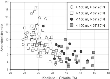
앞에서 살펴본 바와 같이 연구 해역의 대륙붕 퇴적 물과 대륙사면 퇴적물의 점토광물조성과 특성은 차이 가 있는 것으로 생각된다. 즉, 대륙붕 퇴적물은 대륙 사면 퇴적물에 비하여 녹니석과 카올리나이트 함량은 많고 일라이트 결정도는 좋은데 반하여 일라이트와 스멕타이트 함량과 S/I 지수는 작다(Fig. 4, Table 1). 이와 같은 차이는 대륙붕과 대륙사면을 구성하는 퇴적물의 기원지가 다르기 때문인 것으로 해석된다.
또한 대륙붕 퇴적물의 경우 위도에 따라 카올리나
이트와 녹니석 함량이 차이가 나는 것은 점토광물의 근원물질인 주변 육지의 모암 차이를 반영하는 것으 로 판단된다(Fig. 4). 그러므로 대륙붕 퇴적물은 강릉 -동해 주변의 남대천을 비롯한 동해안으로 유입되는 주변 하천으로부터 공급된 것으로 여겨진다. 이러한 사실은 광물의 화학적 풍화작용에 의하여 생성된 인 (P)을 포함하는 퇴적물이 강과 하천을 통하여 동해 인 근해역으로 유입된다는 연구 결과에 의해서도 대륙붕 퇴적물이 동해안으로 유입되는 주변 하천으로부터 공 급된 것으로 확인된다(Cha et al., 2005).
대륙사면 퇴적물은 일라이트와 스멕타이트 함량이
Fig. 3. Relationship between water depth and clay mineral content between continental shel sediments and continen-
tal slope sediment. (A) illite, (B) smectite, (C) chlorite, (D) kaolinite.
높으며(Fig. 4), S/I 지수가 큰 것에 비추어 볼 때 대 륙붕 퇴적물보다 온난한 기후에서 만들어지거나 화산 암 기원의 퇴적물이 더 많이 포함된 때문인 것으로 판단된다. 한반도 주변 해역의 퇴적물에 포함된 스멕 타이트의 양은 일반적으로 5% 이하의 낮은 값을 가 지지만(Choi and Kim, 1998; Cho et al., 2015;
Koo et al., 2018; Lee et al., 2019), 연구 해역 대 륙사면 퇴적물 내 스멕타이트 함량이 평균 9.6%로써 상대적으로 높은 함량을 나타낸다. 동해 표층퇴적물 에 관한 점토광물 연구는 현재까지 이루어진 것이 없 으므로 비교가 불가능하지만 코어 시료에 대한 점토 광물 연구가 이루어진 후포분지와 울릉분지의 경우
역시 스멕타이트 함량이 각각 23.2%와 20.9%로써 매우 높다(Lee et al., 2015). 스멕타이트 함량이 높 은 이유는 한반도 동해안을 따라 분포하는 제3기 퇴 적분지의 화산쇄설암들이 풍화에 의하여 동한해류를 통하여 연구 해역에 유입되었거나(Jun et al., 2014;
Lee et al., 2015), 쿠로시오 해류를 따라 상승하는 스멕타이트가 풍부한 황하 퇴적물이 대한해협을 통하 여 쓰시마난류로 연구 해역에 유입되었을 것으로 여 겨진다(Hong et al., 1997; Jun et al., 2014). 앞으 로 동해 남부 퇴적물에 대한 점토광물 연구가 수행된 다면 연구 해역 퇴적물의 기원지 규명이 보다 확실해 질 것으로 기대된다.
Fig. 4. Ternary diagram of the major clay mineral groups. (A) illite + smectite, kaolinite, and chlorite. (B) smectite, illite, and kaolinite + chlorite.
Fig. 5. Discrimination plot between (S/I) ×100 and (K + C) for marine sediments from different water depth and lati-
tude.
182 구효진 · 최헌수 · 조현구
결 론
강릉-동해 해역에서 채취된 해양 표층 퇴적물 중 120개 시료에 대하여 점토광물 분석한 결과는 다음과 같다.
(1) 점토광물 함량은 일라이트, 녹니석, 카올리나이 트, 스멕타이트 순으로 풍부하다. 스멕타이트와 일라 이트의 함량은 연안에서 낮지만, 외해로 갈수록 풍부 하다. 반면, 카올리나이트와 녹니석은 연안에서 풍부 하고 외해로 갈수록 낮은 함량으로 나타난다.
(2) 대륙붕 퇴적물은 대륙사면 퇴적물에 비하여 녹 니석과 카올리나이트 함량은 많고 일라이트 결정도는 좋은데 반하여 일라이트와 스멕타이트 함량과 S/I 지 수는 작다. 대륙붕 퇴적물의 경우 강릉 쪽은 녹니석 함량이 많고, 동해 쪽은 카올리나이트 함량이 많은데 이것은 육상 지질을 반영한 것으로 여겨진다.
(3) 대륙붕 퇴적물은 하천을 통하여 유입되었고, 대 륙사면 퇴적물은 해류에 의하여 남쪽으로부터 이동된 것으로 판단된다.
사 사
이 연구는 한국지질자원연구원의 ‘국토 지질조사 및 지질도 지질주제도 발간’지원 및 2017년도 정부(교육 부)의 재원으로 한국연구재단의 지원을 받아 수행된 기초연구사업입니다(No. 2017R1D1A1B03027818, 최 후빙기극대기 이후 한반도 주변 고환경 변화 연구; 광 물학적인 방법). 시료 준비 및 분석을 도와준 경상대 학교 지질과학과 이홍금, 김영진, 박원영, 최하늘, 장 정규, 문수인, 정선화, 최재영 학생에게 감사드립니다.
REFERENCES