• 검색 결과가 없습니다.

Developing a Hybrid Web-based GIS for Improving Access to Distributed Spatial Data and Spatial Modeling Tools

N/A
N/A
Protected

Academic year: 2021

Share "Developing a Hybrid Web-based GIS for Improving Access to Distributed Spatial Data and Spatial Modeling Tools"

Copied!
12
0
0

로드 중.... (전체 텍스트 보기)

전체 글

(1)

Developing a Hybrid Web-based GIS for Improving Access to Distributed Spatial Data

and Spatial Modeling Tools

Byong-Woon Jun

1

․Chan-Suk Park

2

․Myung-Hee Jo

3

분산형 공간모델링을 구현하기 위한 하이브리드형 웹기반 GIS의 개발

전병운

1

․박찬석

2

․조명희

3

ABSTRACT

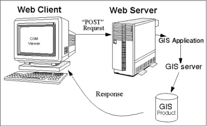
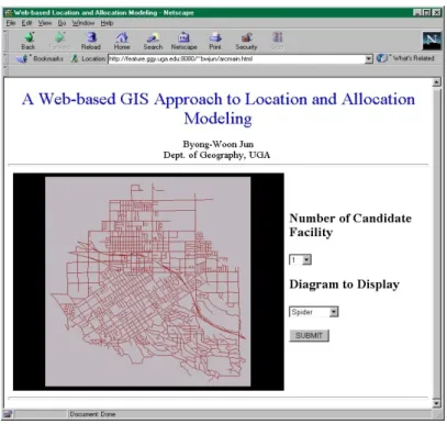
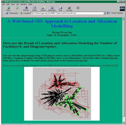
The maturation of the Web technology has reshaped the ways in which data are accessed, disseminated, and shared. Thanks to its popularity along with the advance of spatial information technology, four major changes have been further made in traditional geographic information systems (GIS) in relation to access to data, distribution of data, access to GIS functionality, and visualization of multimedia data. Although access to and dissemination of spatial data over the Web has in recent years been addressed in the literature, little research effort has addressed the issue of access to and processing of GIS analysis functions over the Web. This research explores the potential use of Web-based GIS in improving accessibility to distributed spatial data and spatial modeling tools. A prototype Web-based GIS developed in this study focuses on Web-based location-allocation modeling for spatial decision support, and employs a hybrid approach that uses the Arc/Info software as a GIS server and CGM viewer as a client-side plug-in. This research shows that Web-based GIS is a useful vehicle in conducting spatial modeling in the particular user community. In addition, this study represents the possibility of Web-based GIS in developing open spatial decision supporting systems.

KEYWORDS: GIS, World Wide Web, Distributed Spatial Data, Spatial Modeling

요 약

웹기반 기술의 발달은 데이터의 엑세스와 분산 및 공유를 하는 방법들을 급격하게 변화시키고 있다. 더욱이, 웹의 대중화와 더불어 공간정보기술의 발달은 전통적인 지리정보시스템에 있어서 지 리정보 및 데이터에 대한 엑세스, 공간 데이터의 배분, GIS 기능들에 대한 엑세스, 그리고 멀티미

2000년 8월 10일 접수 Received on August 10, 2000

1 미국 조지아대학교 ([email protected]) Dept. of Geography, University of Georgia, USA

2 경북대학교 ([email protected]) Kyungpook National University

3 경일대학교 측지공학과 (mhjo@bear,kyungil,ac.kr) Dept. of Geodetic Engineering, Kyungil University

(2)

디어 데이터의 비주얼화 같은 네가지 큰 변화들을 야기해 오고 있다. 최근 연구 웹 상에서 공간정 보 및 데이터에 대한 엑세스 및 분산에 관한 연구는 다수 수행되었으나, 웹 상에서 GIS의 분석기 능들에 대한 엑세스와 프로세싱에 관한 연구는 거의 전무한 실정이다. 이에 본 연구는 분산형 공 간정보 및 데이터와 공간모델링 툴들에 대한 사용자들의 접근성을 향상시키는데 있어서 웹기반 GIS의 적용 가능성을 타진하고자 한다. 본 연구에서 개발된 실험단계의 웹기반 GIS는 공간의사결 정을 지원하기 위한 웹기반 변이할당모델링에 초점을 두고 있다. 그리고 본 연구는 GIS 서버로서 Arc/Info 소프트웨어와 클라이언트측의 프러그인으로서 CGM 뷰어를 사용하는 하이브리드 접근법 을 채택한다. 본 연구는 웹기반 GIS가 특정한 사용자그룹간에 분산형 공간정보 및 데이터에 대한 엑세스를 증대시키고, 공간모델링을 수행하는데 있어서 유용한 도구라는 사실을 보여준다. 또한, 본 연구는 개방형 공간의사결정 지윈시스템을 개발하는데 있어서 웹기반 GIS의 잠재적 가능성에 대한 좋은 시사점을 제시한다.

주요어: GIS, 월드 와이드 웹, 분산형 공간 데이터, 공간 모델링

INTRODUCTION

The manner in which data are accessed, shared, and disseminated has drastically been changed by the rise of the World Wide Web (the Web, hereafter) and distributed computing technologies(Ingram, 1996). These technologies which support parts of a database to be stored and maintained at different locations allow users to take advantage of economical or specialized processing at remote sites, decision makers to collaborate across computer networks to make decisions, and large archives to offer access to their data to anyone connected to the Internet (Henriksen, 1992; Burleson, 1994; UCGIS, 1996; Coleman and McLaughlin, 1997).

Furthermore, the Web has helped bring four major changes to traditional geographic information systems(GIS) with respect to access to data, distribution of data, access to GIS functionality, and visualization of multimedia data(Peng, 1999). Some literature in recent years has addressed the issue of spatial data access and dissemination on the Web(Annitto and Patterson, 1995; Onsrud and Rushton, 1995; Coleman and McLaughlin, 1997; Peng

and Nebert, 1997; Plewe, 1997; Harder, 1998;

Lopez, 1998). These studies focused on how we

can access and distribute spatial data on the

Web. Other studies put an emphasis on the

operational methods for spatial data access and

transmission, and interactive mapping(Thoen,

1995; Green, 1997; Limp, 1997; Abel et al.,

1998; Harder, 1998; Lin and Zhang, 1998). The

combination of the effort of the GIS community to

distribute spatial data(Onsrud and Rushton,

1995; Lopez, 1998) and the emergence of

Web-based GIS has created an opportunity to

greatly expand the display and analysis of spatial

data. Although the issue of access to and transfer

of spatial data over the Web has been addressed

in the literature, less attention has been given to

the issue of access to and processing of GIS

analysis functions on the Web. Developments of

most Web-based GIS are limited to interactive

mapping systems, which at best allow users to

perform zooming, panning, and querying

(Thoen, 1995; Plewe, 1997; Peng, 1999). They

generally lack more advanced GIS analysis

functions such as spatial buffering, overlaying,

network analysis, spatial analytical functions,

spatial model, and so on. An imminent challenge

(3)

to the GIS community is thus to break through the limitations of Web-based GIS functionality and to empower Web-based GIS with more analytical ability. The accomplishment of this breakthrough will answer the heated debate as to whether Web-based GIS is a toy or a tool (Thoen, 1995).

This paper addresses the potential use of Web-based GIS in enhancing access to distributed spatial data and spatial modeling tools. It first examines the definition, features, architecture, and major design strategies of Web-based GIS through a literature review. A prototype Web-based GIS for location-allocation modeling is developed and its implementation is followed. Finally, the paper discusses the current problems and future research directions of Web-based GIS.

RECENT DEVELOPMENTS IN WEB-BASED GIS

Integration of GIS with the Web is now an inevitable trend in the GIS community. This development is evolving rapidly. Web-based GIS can be defined as a network-centric GIS model that employs the Web as a major vehicle to access and transmit distributed data and analysis tools, and to conduct analysis and visualization(Peng, 1999). It allows the public or particular users to perform GIS information retrieval, interactive mapping, and analysis on the Web. A Web-based GIS is characterized by the four following features which enable it to be distinguished from traditional GIS. First, Web-based GIS is an integrated client/server network system. It applies the client/server concept in accessing distributed spatial data and performing GIS analysis tasks. It breaks

down the task into server side and client side.

The client can request data, analysis tools, or modules from the server. The server either performs the job itself and sends the results back to the client through the network or sends the data and analysis tools to the client for use on the client side. Second, Web-based GIS is a distributed system. One advantage of the Web is that it can access a distributed database and perform distributed processing.

Information and applications can reside on different computers across the network.

Web-based GIS takes advantage of this distributed system so that the GIS data and analysis tools can reside in different computers on the network(Vckovski, 1998).

Users can access those data and application programs on-demand from anywhere on the network. The user does not have to install the data and application programs in his/her local computer. Third, Web-based GIS is a cross-platform, platform-independent, or heterogeneous system. It can be accessible across platforms regardless of the operating system on the users computer. It can access many forms of GIS data and functions in the heterogeneous environment on the Web.

Fourth, Web-based GIS is a multimedia or hypermedia information system. Traditional GIS is a map-based

A typical Web-based GIS has four components including a three-tier configuration:

a GIS server, a Web server, a client, and

network communication(Figure 1). Each works

as a stand-alone process. A Web client connects

across a network to the GIS Web server

extension. Netscape Navigator and Microsoft

Internet Explorer(IE) are two popular examples

of client programs. A Web server is the bridge

(4)

FIGURE 1. Architecture of Web-based GIS

between a client and a GIS server. It receives request from a client and sends the processed request to the GIS server and then passes the result back to the client. However, there exists a need to develop a GIS Web server extension because of the inability of current major server programs, such as Mircosoft Internet information server and Netscape server, in providing complex communication as needed by GIS. As a result, a GIS Web server extension extends the services of a Web server beyond the simple fetching of files. A GIS server processes the GIS data according to the request coming from the Web server, and then sends the result back to the client via the Web server. The GIS server is the key component in the architecture of Web-based GIS, which takes care of all GIS data analysis and processing. The network allows communication among client/server applications.

The key technique to make this possible is the use of sockets in the TCP/IP(transmission connectivity protocol/Internet protocol) and HTTP(hypertext transfer protocol) protocol suites. In most cases, the Web server and the

GIS server are installed in the same computer.

The sole role of the Web server is waiting for requests, passing them to the GIS server, and then listening for new requests. When a GIS server is busy processing data, the Web server will postpone relaying requests to the GIS server.

Web-based GIS uses the client/server concept as basic communication technology.

Thus, Web-based GIS design strategy is a balance between the weight of server application(heavy/light) and client application (thick/thin) (Plewe, 1997). Four possible combinations of client/server balance are summarized in Table 1. Currently, heavy server, thick client, and GIS client are the three broad design methods, and each has advantages and disadvantages.

In the heavy server design approach,

Web-based GIS depends on the GIS server to

perform analysis and operations and thus

concentrates the processing workload on the

server side. The client side in the application is

simply a user-friendly front-end interface. The

(5)

Heavy server Balanced Thick client GIS client Server

Tasks

Map browsing Query

Analysis Map drawing

Query Analysis Map Drawing

Analysis Map drawing

File serving

Transfer Raster maps Raster/Vector Vector maps Raw data Client

Tasks

Display Display

Map browsing Query input

Display Map browsing Query

Display Map browsing Query

Map drawing Analysis TABLE 1. Four possible combinations of client/server balance (after Plewe, 1997)

major advantage of this type of Web-based GIS is that it does not require users to have powerful computers since the server does most operations. The major disadvantage is the problem of intensive Web-based communication and server processing. Because of the stateless connection between a server and a client, each request from scratch, though maybe only a little different from its last request, will cause the server to start processing from scratch.

Thus, there is always a possibility of the server being overwhelmed in terms of processing when requests are made simultaneously by multiple users, especially for popular sites.

Common gateway interface(CGI) is the most widely used technique for implementing Web-based GIS with the heavy server design strategy(Plewe, 1997; Peng, 1999). A CGI script plays the intermediate role in linking the Web server and the GIS server together and extending server-side applications as GIS applications.

In the thick client design approach, Web-based GIS allows GIS analysis and data processing to be executed on the client side using the users local computer resources. GIS data and analysis modules initially reside on a

server and are transmitted to Web-based GIS with the thick client design strategy. This is the full utilization of the distributed user local computer resources and thus overcomes the problems of heavy network traffic encountered by Web-based GIS with the heavy server design strategy. The major drawback of this type of Web-based GIS is the slowness and inconvenience when downloading and adding components to Web browser software.

Plug-in, ActiveX controls, and Java applets are the major techniques for implementing this type of Web-based GIS(Plewe, 1997; Peng, 1999). GIS plug-ins are small applications installed at the client side to extend the capabilities of Web browsers to handle GIS data whose formats are not recognized by Web browsers. ActiveX controls are modular component ware developed in C++ object oriented language or Visual Basic, based on Mircosofts component object model(COM) standard, which in turn is an extension of the OLE(object linking and embedding) standard.

GIS controls are developed on the server side and

are referenced as embedded objects on the client

side. Developing Web-based GIS with Java is

becoming popular, since Java has the properties

(6)

Heavy server Thick client

CGI-based Plug-ins Java applets ActiveX controls Performance

Client Excellent Good Good Good

Server Poor to good Good Excellent Excellent

Networking Poor Good Good Good

Overall Fair Good Good to excellent Good to excellent Interactivity

User interface Poor Good Excellent Excellent

Function support Fair Good Excellent Excellent

Local data support No Yes No Yes

Portability Excellent Poor Good Fair

Safety Excellent Fair Good Fair

TABLE 2. Assessment of Web-based GIS development approaches (after Peng, 1999) of seamless integration with Web browsers, and

strong graphics handling capabilities(Strand, 1997).

The GIS client approach depends on the client-side to allow GIS analysis and data processing to execute. GIS data initially lie on a server and are transmitted to a GIS client such as ESRI(Environmental Systems Research Institute, Inc.) ArcExplorer. The GIS client allows storing the GIS data locally.

Table 2 gives a comparative assessment of the characteristics of four different techniques for implementing Web-based GIS. The implementation techniques represent different ways of accessing data and processing over the Web in terms of performance, interactivity, portability, and safety. The overall performance of the Web-based GIS depends on the bottleneck caused by the slowest component(Peng, 1999).

DATA AND METHOD

The ESRI sample data, on the Redlands

street network in Arc/Info coverage format, were used to implement a Web-based GIS for location-allocation modeling. The data were originally converted from an ETAK data file containing street geography and address ranges for each street segment. The candidate facility locations and demand locations were contrived and not based on any real data. The software used includes Arc/Info Rev. 7.0.1 as a GIS server and Apache Web server ver. 1.3 as a Web server on an IBM workstation with AIX 4.2.

A prototype Web-based GIS in this research

focuses on an example of Web-based

location-allocation modeling for spatial decision

support, employing a hybrid design strategy that

uses Arc/Info software as a GIS server and a

CGM viewer as a client-side plug-in program. A

hybrid of client-side and server-side processing

which optimizes the partition of client and server

tasks was used in this research because it

combines the advantage of server power and

client flexibility. The client/server model in this

study is focused on a typical three-tier

(7)

FIGURE 2. Architecture of a hybrid Web-based GIS client/server configuration using a CGI process.

The CGI implementation technique was used to obtain more flexibility in linking the Web server and the GIS server and extending server-side applications as GIS applications.

There are three possible strategies to integrate the GIS server with the Web server.

First, a stand-alone approach is to create unique GIS mapping servers from scratch with any programming language such as C/C++ and Java applet(Jun, 1998). Xerox Map Server and TIGER mapping services are good examples for this purpose. Second, a loose-coupling approach develops a user interface between a GIS server and a Web server using any script languages such as C shell script, Tcl/Tk, AML (Arc macro language), or PERL(Huse, 1995;

Zhuang and Egel, 1995; Usery et al, 1998).

Third, a tight or close coupling approach builds a real-time link between a GIS server and Web server using IPC(inter-process communication) /RPC(remote procedure call) in Unix, DDE (dynamic data exchange)/OLE(object linking and embedding) in Windows, and AppleEvents

in Macintosh. This category includes most commercial software such as ESRI ArcIMS/

ArcView Internet Map Server/MapObjects Internet Map Server, Autodesk Map Guide, MapInfo ProServer, Intergraph GeoMedia Web Map, and Genasys Spatial WebBroker. The loose-coupling approach was used for this research because it allows using most built-in GIS functions, which are already fully developed (Usery et al., 1998).

Figure 2 shows a hybrid design structure of the Web-based GIS. The Web-based GIS consists of three components: Web Forms interface, batch processing, and AML program.

The first component is the Web Forms interface,

an HTML document that enables the user to

identify variables such as number of candidate

facilities and diagram to display. The output of

this page is passed to a CGI script, which parses

the output and sends it to a C shell script. A

batch process then initiates the second

component of the interface. The batch begins a C

shell script, which reads the request file and

parses it into individual requests. The requests

(8)

FIGURE 3. Initial menu of Web-based location-allocation modeling are processed one at a time and sent to the third

component: an Arc/Info AML. The AML processes each request sent by the CGI program - performing location-allocation modeling and then creating a map in CGM(computer graphic metafile) format - and posts a map to an HTTP directory with the specified filename to be retrieved interactively.

The CGM format was used primarily to kill a long transaction time of graphic conversion. It stores vector information and allows viewing with pan, and zoom with no loss of detail. The biggest disadvantage is that CGM files cannot be viewed with native browsers such as Netscape. The Metaweb software(from Henderson Software) was used as a client-side plug-in viewer in this research. Another disadvantage is that CGM files are much larger than GIF files - perhaps 10 times larger.

IMPLEMENTATION AND RESULTS

A hybrid Web-based GIS has been developed

to show its feasibility in improving accessibility to

spatial modeling tools on the Web. This section

implements it through an example of

location-allocation modeling. Suppose we have

an urban area and we wish to locate some

libraries. The question is what is the best

number of libraries to locate? This question is a

simple p-median problem. Location-allocation is

the process of determining the best, or optimal,

location for one or more facilities so that the

service or good is accessible to the population in

the most efficient manner(Ghosh and Rushton,

1987). The models optimize efficiency by

simultaneously determining the configuration of

the facilities and assigning the people to the

(9)

FIGURE 4. Visualization of the modeling result facilities. The model in this example is referred

to as the 'minimize total powered distance model' in the operational research(OR) literature. This model minimizes the total distance travelled where distance is computed according to squared, cubed, or some power function(Ghosh and Rushton, 1987). This is generally used to implement public facilities planning and appropriate for an experiment.

The Web-based GIS generates a simulated location-allocation modeling map. The user is allowed to enter a number of candidate facilities and a diagram type to display. The Web-based GIS involves an HTML input form requesting a GIS server application that utilizes the user input to produce the map product(Figure 3). To produce the desired results the GIS server application uses GIS functions to perform

location-allocation modeling and aggregates the information in order to produce the map product.

The click to locate the submit button submits the information from the Web client to the Web server. Upon receiving the information the Web server reads the submitted information and determines if it is a POST to the GIS server process. The Web server then spawns the GIS server process and forwards the information to the newly spawned process. The GIS server process reads the incoming information, creates uniquely named temporary output files to hold the status log, starts the batch GIS application, and sends a response back to the Web server.

The Web server forwards this message back to the Web client, and control of the client is returned to the user(Figure 4).

The Web-based GIS provides users with

(10)

easy access to appropriate data, spatial models, and GIS via user-friendly Web browsers. It also allows users to experiment with choice alternatives to seek optimal solutions to the spatial problem. This example gives us a research insight into how Web-based location-allocation models can be used as a tool to support decision making in urban spatial planning. As for performance, it took around 20 seconds to process a request due to the use of the CGM data format.

FURTHER DISCUSSIONS

Though some progress was made in recent developments of Web-based GIS, there are several issues to be resolved. The first issue is the performance. GIS data, especially raster and image data, are huge in volume. They take a long time to transfer over the Web. This poses a big problem especially for slow Internet connection like modems. How can a very large spatial database be indexed for efficient retrieval and complex searching? We need to seek a new technology such as a spatial database engine to solve this problem(Zhuang, 1997).

The second issue is the gap between GIS and the Web. The underlying data model of traditional GIS, which is essentially developed in the context of cartography, is not suitable as the base to develop Web-based GIS. The data structure and analysis modules of most current GIS software are very difficult to package into components as electronic parcels and transmit across distributed systems. Newly emerging object oriented, component object model (COM), and common object request broker architecture(CORBA) approaches show promising solutions to this problem, as they offer extended

capabilities for saving repetitious work, reducing the size of data transferring through the Web and fully integrated objects and components(Chi and Tao, 1998).

The third problem with current Web-based GIS is the lack of appropriate techniques suitable for implementing Web-based GIS. Current common Web implementation techniques such as CGI, plug-ins, ActiveX controls, and Java are for developing Web applications in a broad sense rather than for developing Web-based GIS specifically. Exploring new techniques for Web- based GIS implementation can be worthwhile.

The last critical issue at the current stage of research development is to develop standards for the future interoperability among different spatial data formats and geoprocessing software.

Open GIS technology, which was created by Open GIS Consortium Inc. sounds quite promising (Karimi, 1996; Vckovski, 1998; Vckovski et al., 1999).

CONCLUSION

This research explored a hybrid Web-based

GIS approach to improving accessibility to

distributed spatial data and spatial modeling

tools through an example for location-allocation

modeling on the Web. The hybrid design

approach allowed combining the advantage of

server power and client flexibility. Employing a

CGM viewer as a client-side plug-in provided a

powerful tool for visualizing spatial data. The

use of CGM graphic format also significantly

curtailed the processing time on the

server-side. The loose coupling strategy in

bridging a GIS server and Web server facilitated

adding most built-in GIS analytical functions on

Web-based GIS.

(11)

This research shows that Web-based GIS is a useful vehicle for accessing distributed spatial data and conducting GIS processing and spatial modeling among a particular user community by removing geographical and physical constraints to involvement and reducing the need for users to own the data or software system. This study also gives us a research insight into the applicability of Web-based GIS in developing open spatial decision supporting systems where a decision-making process in solving spatial problems demands significant input from the public. The GIS research community is looking for new challenges in future developments of Web-based GIS in terms of users, developers, and institutions.

ACKNOWLEDGEMENT

The authors are very grateful to Prof. E.

Lynn Usery, Department of Geography at the University of Georgia for his valuable comments and suggestions.

REFERENCES

Abel, D.J., K. Taylor, R. Ackland and S.

Hungerford. 1998. An Exploration of GIS Architectures for Internet Environments.

Computer, Environment and Urban Systems 22(1):7-23.

Annitto, R.N. and B.L. Patterson. 1995. A New Paradigm for GIS Data Communication.

Journal of Urban and Regional Information Systems 7(1):64-67.

Burleson, D.K. 1994. Managing Distributed Database: Building Bridges between Database Islands. John Wiley & Sons, New York, NY, USA. 384pp.

Chi, Z. and Y. Tao. 1998. Internet GIS:

the Development of the Integrated GIS and Network. Proceeding of GIS/LIS 98 Annual Conference. Fort Worth, TX, Nov. 10-12, 1998. published on CD-ROM.

Coleman, D.J. and J.D. McLaughlin. 1997.

Information Access and Network Usage in the Emerging Spatial Information Marketplace.

Journal of Urban and Regional Information Systems 9(1):8-19.

Ghosh, A. and G. Rushton. 1987. Spatial Analysis and Location-Allocation Models.

Van Nostrand Reinhold Company, New York, NY, USA. 373pp.

Green, D.R. 1997. Cartography and the Internet. The Cartographic Journal 34(1):23-27.

Harder, C. 1998. Serving Maps on the Internet. ESRI, Inc., Redlands, CA, USA, 130pp.

Henriksen, C. 1992. Why Distributed GIS Works. GIS World 5(4):78-81.

Huse, S.M. 1995. GRASSLinks: A New Model for Spatial Information Access in Environmental Planning. Ph.D. Dissertation, Univ. of California, Berkeley, USA. 87pp.

Ingram, P. 1996. Web developments and the Internet. Computers & Geosciences 22(5):579-584.

Jun, B.W. 1998. Integration of GIS with the World Wide Web (WWW) Using Java.

Paper presented at 13th Annual Meeting of the Southeastern Geography Student Conference, Feb. 6-7, 1998, Athens, GA, USA.

Ki-Dong Bu and Myung-Hee Jo, 1998, A

Study on the GUI Development Methods

for GIS Construction under the Intranet

Environment, Journal of the Korean

Association of Regional Geographers

4(2):139-150

(12)

Karimi, H. 1996. Open Computing GIS: An Effective, Affordable Approach to Solving Spatial Problems. GIS World 7(3):48-51.

Limp, W.F. 1997. Weave Maps across the Web. GIS World 10(9):46-55.

Lin, H. and L. Zhang. 1998. Internet-based Investment Environment Information System:

A Case Study on BKR of China.

International Journal of Geographical Information Science 12(7):715-725.

Lopez, X. 1998. The Dissemination of Spatial Data, Ablex Publishing Co., Greenwich, CT, USA, 234pp.

Onsrud, H.J. and G. Rushton. 1995.

Sharing Geographic Information. The Center for Urban Policy Research, New Brunswick, NJ, USA, 510pp.

Peng, Z. 1999. An Assessment Framework for the Development of Internet GIS.

Environment and Planning B 26(1):117-132.

Peng, Z. and D. Nebert. 1997. An Internet-based GIS Data Access System.

Journal of Urban and Regional Information Systems 9(1):20-30.

Plewe, B. 1997. GIS Onlne: Information, Retrieval, Mapping, and the Internet.

OnWord Press, Santa Fe, NM, USA, 311pp.

Strand, E.J. 1997. Java Creates New Channels for GIS Information. GIS World 10(5):28-29.

Thoen, B. 1995. Interactive Mapping and GIS Thrive on the Web. GIS World 8(10):58-59.

University Consortium for Geographic Information Science. 1996. Research Priorities for Geographic Information Science of UCGIS.

Cartography and Geographic Information Systems 23(3):115-127.

Usery, E. L., J.C. Seong and B.W. Jun.

1998. Implementing GIS Software over the World-Wide-Web. Proceedings of ASPRS-RTI 98 Annual Conference, Tampa, FL, Mar.

31-Apr. 3, 1998, pp.623-629.

Vckovski, A. 1998. Interoperable and Distributed Processing in GIS. Taylor &

Francis, Bristol, PA, USA, 230pp.

Vckovski, A., K.E. Brassel and H-J.

Schek. 1999. Interoperating Geographic Information Systems. Springer, Berlin, NY, USA. 327pp.

Zhuang, V. 1997. Spatial Engines Drive Web-based GIS. GIS World 10(10):54-58.

Zhuang, X. and B.A. Egel. 1995. Tcl/Tk

GUI Tool Kit Offers Cross-application

Development. GIS World 8(7):58-60.

수치

FIGURE  1.  Architecture  of  Web-based  GIS
TABLE  2.  Assessment  of  Web-based  GIS  development  approaches  (after  Peng,  1999)of  seamless  integration  with  Web  browsers,  and
FIGURE  2.  Architecture  of  a  hybrid  Web-based  GISclient/server  configuration  using  a  CGI  process
FIGURE  3.  Initial  menu  of  Web-based  location-allocation  modelingare  processed  one  at  a  time  and  sent  to  the  third
+2

참조

관련 문서