• 검색 결과가 없습니다.

Status of Groundwater Potential Mapping Research Using GIS and Machine Learning

N/A
N/A
Protected

Academic year: 2021

Share "Status of Groundwater Potential Mapping Research Using GIS and Machine Learning"

Copied!
14
0
0

로드 중.... (전체 텍스트 보기)

전체 글

(1)

Korean Journal of Remote Sensing, Vol.36, No.6-1, 2020, pp.1277~1290

https://doi.org/10.7780/kjrs.2020.36.6.1.1 ISSN 1225-6161 ( Print )

ISSN 2287-9307 (Online)

Review

GIS와 기계학습을 이용한 지하수 가능성도 작성 연구 현황

이사로 1),2)†·Rezaie Fetemeh 3),4)

Status of Groundwater Potential Mapping Research Using GIS and Machine Learning

Lee Saro

1),2)†

· Rezaie Fetemeh

3),4)

Abstract: Water resources which is formed of surface and groundwater, are considered as one of the pivotal natural resources worldwide. Since last century, the rapid population growth as well as accelerated industrialization and explosive urbanization lead to boost demand for groundwater for domestic, industrial and agricultural use. In fact, better management of groundwater can play crucial role in sustainable development; therefore, determining accurate location of groundwater based groundwater potential mapping is indispensable. In recent years, integration of machine learning techniques, Geographical Information System (GIS) and Remote Sensing (RS) are popular and effective methods employed for groundwater potential mapping. For determining the status of the integrated approach, a systematic review of 94 directly relevant papers were carried out over the six previous years (2015-2020). According to the literature review, the number of studies published annually increased rapidly over time. The total study area spanned 15 countries, and 85.1% of studies focused on Iran, India, China, South Korea, and Iraq. 20 variables were found to be frequently involved in groundwater potential investigations, of which 9 factors are almost always present namely slope, lithology (geology), land use/land cover (LU/LC), drainage/river density, altitude (elevation), topographic wetness index (TWI), distance from river, rainfall, and aspect. The data integration was carried random forest, support vector machine and boost regression tree among the machine learning techniques. Our study shows that for optimal results, groundwater mapping must be used as a tool to complement field work, rather than a low-cost substitute. Consequently, more study should be conducted to enhance the generalization and precision of groundwater potential map.

Key Words: Groundwater, Machine Learning, GIS, Literature Review

Received October 20, 2020; Revised November 30, 2020; Accepted November 30, 2020; Published online December 2, 2020

1)

한국지질자원연구원(KIGAM) 지오플랫폼연구본부 책임연구원 (Principal Resarcher, Geoscience Platform Research Division, Korea Institute of Geoscience and Mineral Resources (KIGAM))

2)

한국과학기술대학원대학교 물리탐사공학과 정교수 (Professor, Korea University of Science and Technology)

3)

한국지질자원연구원(KIGAM) 지오플랫폼연구본부 박사과정생 (PhD Student, Geoscience Platform Research Division, Korea Institute of Geoscience and Mineral Resources (KIGAM))

4)

한국과학기술대학원대학교 물리탐사공학과 박사과정생 (PhD Student, Korea University of Science and Technology)

Corresponding Author: Lee Saro ([email protected])

This is an Open-Access article distributed under the terms of the Creative Commons Attribution Non-Commercial License

(http://creativecommons.org/licenses/by-nc/3.0) which permits unrestricted non-commercial use, distribution, and reproduction in

any medium, provided the original work is properly cited.

(2)

1. 서론

지하수는 농업과 산업 활동뿐만 아니라 지역사회를

위한 가장 중요한 천연자원 중 하나이다 . 본 연구에서

다루는 지하수 가능성도는 이러한 지하수 연구의 중요 한 측면 중 하나로 , 수자원 관리자들이 더 나은 개발과 보존 계획을 가질 수 있도록 도울 수 있다 . 이러한 지하 수 가능성도는 수자원의 체계적인 개발과 계획을 위한

도구로 정의되어 왔다 . 이 지도는 지하수 자원의 지속

가능한 관리를 위한 전략을 개발하기 위해 사용될 수

있다 . 구체적으로는 지하수 가능성도를 이용하여 지하

수를 개발을 위해 관정을 설치하기에 적합한 위치를 선 정하는데 사용될 수 있다 .

지하수 가능성도 작성은 예측도 작성의 한 예로, 일 련의 간접 지표(예측 변수)에 기초하여 대상 변수에 대 해 공간적으로 분산된 추정치를 계산한다. 예측지도는 기존 지도, 항공사진, 위성사진, 지질 정보에서 파생된 데이터의 통합을 통해 작성된다. 지하수 산출 가능성이 있는 지역을 식별하기 위한 전통적인 접근방식은 특히 접근하기 어려운 지역의 경우 일반적으로 비용이 많이

들고 시간이 많이 소요되는 지구물리학 , 지질학 및 수

리지질학 방법에 기초한 지상 조사에 주로 의존한다 . 그 러므로 시간가 비용을 줄이기 위해서는 지하수 산출 가 능성 지역을 기존 정보를 최대한 활용할 수 있는 데이

터 기반의 접근법을 필요로 한다 . 이에 지리정보시스템

(GIS)과 기계학습 모델을 결합하여, 매우 높은 효율로

지하수가 산출 가능 구역을 예측할 수 있는 지하수 가 능성도 작성 방법론이 제시되었다.

실제로 기계학습 등의 데이터 기반 모델은 공간 분 석 및 모델링, 특히 지하수 가능성 모델링 분야에서 인 기를 얻고 있다 . 특히, 이러한 접근방식은 물리 기반 및

수치 모델을 수행하기에 충분한 지질학적 , 수학적 지질

학적 데이터가 없을 수 있는 대규모 지역에 대한 지하 수 가능성도 작성 과제를 해결할 때의 가능성을 보여주

었다 . 기계학습 모델의 주요 이점은 다양한 유형의 요

인을 모델링 학습에 사용하고 , 통합할 수 있고 누락된

데이터를 처리할 수 있다는 것이다 . 또한 종속변수와 독 립변수 간의 비선형 상관관계를 고려하여 기계학습 모 델로 해결할 수 있다. 기존의 방법(이변량 및 다변량 통

계법 )에 비해 기계학습의 장점 중 하나는 기계학습 모

델이 데이터의 이상치를 처리할 수 있고 불확실한 데이 터와 제한된 측정 오류가 존재하는 경우에도 정확하다 는 점이다 .

문헌 검토에 대한 조사를 통해 기계학습 및 GIS 기반 모델이 지하수 가능성도 작성에 유효하다는 것을 알 수

있다 . 지하수 가능성도 작성을 위한 주요 방법은 전문

가 기반, 확률통계, 기계학습, 앙상블 모델 등으로 분류 할 수 있다. 먼저 전문가 기반의 방법에서는 다중 기준 의사결정(MCDM) 및 분석 계층 프로세스(AHP) 모델을 포함한 전문가 기반 방법이 주로 사용되었다 (Andualem and Demeke, 2019; Tiwari et al., 2019; Paul et al., 2020). 확

률통계 분야에서 가장 많이 채용되는 GIS 기반 방법은

요약 : 지표수와 지하수로 이루어진 수자원은 세계적으로 가장 중요한 천연자원 중 하나로 여겨진다 . 지난 세 기 이후 급속한 산업화와 급증하는 인구로 인해, 생활용, 산업용, 농업용수 수요가 급증하고 있으며, 이에 대한 지하수 수요도 급증하고 있다 . 따라서 지하수에 대한 지속 가능한 개발과 관리를 위해서는 정확한 위치기반의 지하수 가능성도 작성이 필수적이다 . 최근에는 기계학습과 지리정보시스템 통합이 지하수 가능성도 작성에 효과적인 방법이 되고 있다 . 이러한 통합접근법의 현황 파악을 위해 6년(2015~2020년) 동안 94편의 직접 관련 논문에 대한 체계적 검토를 실시했다. 문헌 검토에 따르면, 매년 발간되는 연구의 수는 시간이 지남에 따라 급 격히 증가했다 . 전체 연구 분야는 15개국에 걸쳐 있으며, 85%의 연구가 이란, 인도, 중국, 한국, 이라크에 집중 되었다 . 지하수 산출 가능성 조사에는 20개의 변수가 자주 사용된 것으로 조사되었으며, 이 중 지형고도, 경사, 경사방향 , 지형습도지수, 지질, 토지 이용 피복, 하천 밀도, 강과의 거리, 강우량 등이 자주 사용되는 것으로 나타 났다. 기계학습 모델에 있어 랜덤 포레스트, 서포트벡터머신, 부스트 회귀트리 등의 방법이 많이 사용되었다.

이러한 문헌 연구는 최적의 결과를 위해 지하수 가능성도를 저비용 대체물이 아닌 현장 작업을 보완하는 도구

로 사용해야 한다는 것을 보여준다 . 마지막으로, 향후, 지하수 가능성도 작성의 표준화 및 정확성을 개선하기

위해 더 많은 연구가 진행되어야 할 것이다 .

(3)

빈도비 (Altafi Dadgar et al., 2017; Guru et al., 2017; Das, 2019), Weight of Evidence(Tahmassebipoor et al., 2016;

Ghorbani Nejad et al., 2017), Dempster-Shafer 이론 (Mogaji et al., 2015; Rahmati and Melesse, 2016; Haghizadeh et al., 2017), evidential belief function (Naghibi and Pourghasemi, 2015; Khoshtinat et al., 2019), Certainty Factor(Razandi et al., 2015; Hou et al., 2018; Nhu et al., 2020), 통계 지수(Falah et al., 2017; Hahgizadeh et al., 2017; Hou et al., 2018; Nhu et al., 2020) Index of Entropy (Al-Abadi and Shahid, 2015; Al- Abadi et al., 2016; Karimi et al., 2020) 등이 있다. 최근 기계 학습은 지하수 데이터에 숨겨진 패턴을 인식하고 변수 간 비선형 관계를 분석해 연구자들의 관심을 끌고 있다.

지하수 조사에서 가장 널리 구현된 기계학습 모델은 랜 덤 포레스트(Kim et al., 2019; Miraki et al., 2019; Rahmati et al., 2019; Kamali Maskuni et al., 2020;), 최대 엔트로피 (Rahmati et al., 2016; Golkarian and Rahmati, 2018) 등이다.

지원 벡터 머신 (Rahmati et al., 2018; Al-Fugara et al., 2020;

Prasad et al., 2020), 인공신경망(Lee et al., 2018; Sameen et al., 2019; Pal et al., 2020), 의사결정 트리(Sameen et al., 2020), 로지스틱 회귀 (Park et al., 2017; Arabameri et al., 2020), 회귀 트리 (Naghibi et al., 2016; Naghibi and Pourghasemi, 2015), K-nearest neighbors (Naghibi et al., 2018; Al-Abadi and Alsamaii, 2020), 다변량 적응 회귀 스플라인(Zabihi et al., 2016; Park et al., 2017; Golkarian et al., 2018), 일반화된 첨 가 모델 (Falah et al., 2017; Naghibi et al., 2017a), naïve Bayes (Chen et al., 2019b; Martínez-Santos and Renard, 2019;

Miraki et al., 2019), 그리고 선형 및 4차 판별 분석(Naghibi and Moradi Dashtpagerdi, 2016; Kalantar et al., 2019) 등이 있으며, 이는 지하수 가능성도 작성 분야에서 유용하고 좋은 결과를 도출한 것으로 확인되었다. 그러나 최근 몇 년간 앙상블 모델이 점점 더 많이 사용되고 있다. 즉, genetic-based support vector machine and random forest (Naghibi et al., 2017b), ensemble weights-of-evidence with logistic regression (Chen et al., 2018b), evidential belief function and boosted regression tree (EBF-BRT) algorithms (Kordestani et al., 2019), hybridization of Fisher’s linear discriminant function with rotation forest (Chen et al., 2019a), integration of artificial neural networks with RealAdaBoost (Nguyen et al., 2020a), adaptive neuro-fuzzy inference system (ANFIS) ensemble with teaching-learning

basedoptimization(TLBO), biogeography-basedoptimization (BBO) (Chen et al., 2019c), and Bagging based Decision Stump (Pham et al., 2019) 등이 매우 좋은 결과를 도출하 였으며 , 이는 지하수 가능성도 작성에 있어서 모델의 성 능이 크게 향상됐다는 것이다 .

본 연구에서 증명될 것처럼, 지하수 가능성 지도에 새로운 방법을 적용하는 것에 대한 관심이 최근 몇 년 동안 급격히 증가했다. 따라서, 본 연구에서는 지난 10

년 동안 GIS를 이용하여 지하수 가능성도 작성 방법에

대한 최신 연구를 정리 분석하였다 .

2. 연구방법

스코퍼스 (www.scopus.com) 데이터베이스를 이용하여, 2015~2020년 6년 동안에 게재된 GIS 기반 지하수 가능 성도 작성 논문을 검색하기 위하여 GIS, 지하수, 기계학 습이라는 검색어를 교집합 개념으로 적용하여 영어로 게재된 연구 논문을 검색하였다. 이 검색에 이어 제목

과 요약문에 따라 초기 논문의 선정이 이루어졌다 . 그

후 , 논문 전문을 검토하여 논문의 최종 선택이 이루어

졌다 . 본 연구에서는 2015년 이전의 논문도 검색하였

으나 , 실제로 위의 검색어를 사용하여 검색하였을 때,

발행된 논문의 수가 미미하여 실제 본격적으로 논문이 발생된 2015년부터 2020년까지의 논문에 대해 분석하

였다 . 이는 기계학습을 적용한 지하수 산출 가능성도

작성 연구분야가 매우 최근부터 이루어졌다는 것을 증 명한다 . 이렇게 취합된 논문은 연차 별 게재 횟수, 연구 지역(국가), 사용 요인, 사용 모델 등을 기준으로 분류되 었고, 이를 분석하였다.

3. 연구 결과

1) 출판된 논문의 일시적 경향

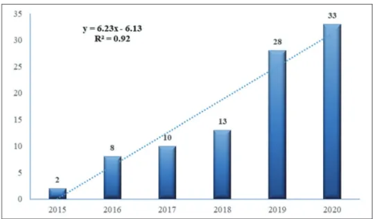
2015~2020년에는 GIS 및 기계학습 기반 지하수 가능 성 지도 작성에 관한 94건의 논문이 게재되었다. 일반적

으로 , 매년 발행되는 논문의 수는 시간이 지남에 따라

증가했다 (Fig. 1). 2015년 2편의 논문만 게재된 데 비해

2020년에는 33편의 논문이 발행되었다. 전체 연구 기간

(4)

(2015~2020년) 동안 연간 논문 수를 보면 추세선의 기울 기는 6.23, 결정계수(R

2

)는 0.92로 매우 급하게 그리고 신 뢰성이 높은 증가를 나타내었다 .

2) 연구 지역 (국가)

조사된 논문의 연구 지역 (국가)은 15개국의 지역(Fig. 2) 을 포함하였으나 , 논문의 85.1%는 5개국에서 유래하였다.

가장 많이 연구된 국가는 이란 (35건, 37.2%), 인도(27건, 28.7%), 중국(8건, 8.5%), 한국(6건, 6.4%), 이라크(4건,

4.3%) 순이었다. 이 연구들의 대표적인 예로는 이란, 인도, 중국, 한국, 이라크의GIS기반지하수지도가각각Avand et al. (2020), Das and Pardeshi (2018), Duan et al. (2016), Lee et al. (2020), Al-Abadi and Shahid (2016) 등이 있다. 이러

한 연구지역은 지표수 자원의 부족과 인구증가 , 농업

확장, 급속한 도시화, 근대산업 활동으로 지하수에 대

한 수요가 매우 높다 . 따라서 지하수 가능성도 작성이

매우 필요하며 , 특히 이러한 지하수 가능성도 작성에 효 과적이고 효율적인 방법을 적용할 필요가 있다.

Fig. 1. Number of published articles in the research field from 2015 to 2020.

Fig. 2. Number of published articles with respect to study area from 2015 to 2020.
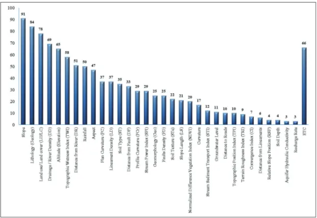
(5)

3) 사용 요인

지하수 가능성 지도는 전형적으로 다양한 요인에 의

존한다 . 일반적인 가정은 지하수 발생을 지표면 및 지

하의 구성 물질의 특성에서 예측할 수 있다는 것이다.

이러한 다양한 요인에는 토양 , 선 구조, 지형경사, 지질, 지형형태 , 배수 밀도 등이 있다. 반면에 지하수 가능성 도 작성에 있어서 사용되는 요인에 대한 보편적이고 표 준화된 지침은 없다. 따라서 많은 연구들에서는 매우 다 양한 요인들을 연구해 왔다 . 예를 들어, Al-Fugara et al.

(2020)은 강우량, 고도, 배수네트워크까지의거리, 경사면 및 지질이 다른 조사된 변수들보다 지하수 가능성도 작성 에 더 중요한 요인이라는 것을 보여주었다. Al-Ruzouq et al. (2019)은 지질, 강우량, 지형이 주요 요인임을 보여주 었고 , 반면 경사도와 선 구조 밀도는 덜 중요한 요인임 을 분석하였다 . Rahmati et al. (2018)은 상대 경사 위치, 단 층으로 부터의 거리 , 지질이 가장 중요한 요인이라고 밝 혔다. Naghibi et al. (2017b)은 식생지수(NDVI), 고도, 경

사가 가장 중요한 요인으로 분석됐다고 언급했다 . 이러

한 요인의 중요성의 변동은 연구 지역의 지질학적 , 기

후적 , 지형적 특징 간의 차이와 관련이 있을 수 있다. 더 욱이 이러한 변수나 지표의 선택은 주로 연구의 목적, 데이터의 가용성 , 전문가의 의견 등에 따라 달라지기 때

문에 사용된 요인들이 연구마다 다르다 .

Table 1에 기술된 바와 같이, 많은 연구들이 언급된 요 인들을 이용한 지하수 가능성도 작성에 이용하였다. 또 한 Fig. 3에서 보듯이 연구 논문 검토를 토대로 하여 가장 많이 사용된 요인은 경사 (총 물품의 96.8%), 지질(89.4%), 토지이용 /토지피복(83.0%), 배수/하천 밀도(73.4%), 고 도(69.1%), 지형습도지수(TWI)(61.7%), 하천과의 거리 (54.3%), 강우(53.2%), 경사방향(50%) 등이었다. 여기서 중요한 것은 이러한 사용될 요인의 선택과 효율적인 통 합 모델의 적용이 지하수 가능성도 작성에 가장 핵심이 라는 점이다 .

4) 방법

지하수 탐사는 지하에 숨겨진 천연자원이고 쉽게 탐 지할 수 없다 . 따라서 지하수 가능성도 제작을 위해 전 통적인 표면과 지표 아래의 잠재적 평가 방법에서부터 최근의 기계학습 방법에 의한 예측 모델에 이르기까지 다양한 방법이 제안되고 이용되고 있다 . 지질도, 수리지

Ta bl e 1. L ite ra tu re s o n se lec tio n of m en tio ne d co nd itio nin g pa ra m et er s f or g ro un dw at er p ot en tia l m ap pi ng /m od eli ng Re fer en ce s Sl op e Li tho log y LU /L C DD Al titu de TW I DR Ra inf all As pe ct PC LD So il Ty pe DF PC r SP I Ge o FD ST r LS ND VI Te rm eh et al ., 2 01 9a · · · · · · · · · · · · · · · Pr as ad et al ., 2 02 0 · · · · · · · · · · · · · · Na gh ibi an d D as htp ag erd i, 2 01 6 · · · · · · · · · · · · · · Na gh ibi an d P ou rg ha se mi , 2 01 5 · · · · · · · · · · · · · · Pa rk et al ., 2 01 7 · · · · · · · · · · · · · · Ti en B ui et al. , 2 01 9 · · · · · · · · · · · · · · Ka lan tar et al ., 2 01 9 · · · · · · · · · · · · · · Ch en et al ., 2 01 9c · · · · · · · · · · · · · Ch en et al ., 2 01 9b · · · · · · · · · · · · · M ou sa vi et al. , 2 01 7 · · · · · · · · · · · · · Go lka ria n e t a l., 20 18 · · · · · · · · · · · · · Na gh ibi et al ., 2 01 9 · · · · · · · · · · · · · Ar ab am eri et al ., 2 01 9a · · · · · · · · · · · · ·

(6)

Ta bl e 1. C on tin ue d Re fer en ce s Sl op e Li tho log y LU /L C DD Al titu de TW I DR Ra inf all As pe ct PC LD So il Ty pe DF PC r SP I Ge o FD ST r LS ND VI Na gh ibi et al ., 2 01 8 · · · · · · · · · · · · · Na gh ibi et al ., 2 01 6 · · · · · · · · · · · · · Ka ma li M as ko on i e t a l., 20 20 · · · · · · · · · · · · · Ar ab am eri et al ., 2 02 0 · · · · · · · · · · · · · Te rm eh et al ., 2 01 9b · · · · · · · · · · · · · Za bih i e t a l., 20 16 · · · · · · · · · · · · · Ch en et al ., 2 02 0 · · · · · · · · · · · · Fa lah et al ., 2 01 7 · · · · · · · · · · · · Al -F ug ara et al ., 2 02 0 · · · · · · · · · · · · Ch en et al ., 2 01 9a · · · · · · · · · · · · Ar ab am eri et al ., 2 01 9b · · · · · · · · · · · · Go lka ria n a nd R ah ma ti, 20 18 · · · · · · · · · · · · Ch en et al ., 2 01 8b · · · · · · · · · · · · Ko rd es tan i e t a l., 20 19 · · · · · · · · · · · · Kh os rav i e t a l., 20 18 · · · · · · · · · · · · Na gh ibi et al ., 2 01 7a · · · · · · · · · · · Av an d e t a l., 20 20 · · · · · · · · · · · M ira ki, 20 19 · · · · · · · · · · · Th ap a e t a l., 20 17 · · · · · · · · · · · Na gh ibi et al ., 2 02 0 · · · · · · · · · · M uk he rje e a nd Si ng h, 20 20 · · · · · · · · · · Th ap a e t a l., 20 18 · · · · · · · · · · M all ick et al ., 2 01 9 · · · · · · · · · · Pa tra et al ., 2 01 8 · · · · · · · · · Bi sw as et al ., 2 02 0 · · · · · · · · · Ar ulb ala ji e t a l., 20 19 · · · · · · · · · Ng uy en et al ., 2 02 0b · · · · · · · · · Be njm el et al. , 2 02 0 · · · · · · · · · Ah ma d e t a l., 20 20 · · · · · · · · · LU /L C: L an d U se /L an d C Ov er, D D: D rai na ge /R ive r D en sit y, TW I: To po gr pa hic W etn es s I nd ex , D R: D ist an ce fr om R ive r, P C: P lan C ur va tur e, LD : L ine am en t D en sit y, DF : D ist an ce fr om F au lt, PC r: Pr of ile C ur va tur e, SP I: St rea m Po we r I nd ex , G eo : G eo mo rp ho log y, FD : F au lt D en sit y, ST r: So il T ex tur e, LS : S lop e L en gth

(7)

Fig. 4. Number of published articles with respect to methods used from 2015 to 2020.

Ensemble Models: ANFIS-x: Hybrid ANFIS models (ANFIS-IWO, ANFIS-DE, ANFIS-FA, ANFIS-PSO, ANFIS-BA, ANFIS-TLBO, ANFIS-BBO); RF-GA:Hybrid Random Forest-Genetic Algorithm / Supervised Models: RF:Random Forest; SVM:Support Vector Machine;

BRT:Boosted Regression Tree; DAs:Discriminant Analysis models (LDA, FDA, QDA, PDA); LR:Logistic Regression; MARS:Multivariate Adaptive Regression Spline; EBF: Evidential Belief Functions; FT: Functional Tree; CART: Classification and Regression Tree; Bagging;

NB: Naïve Bayes; ANN: Artificial Neural Network; AdaBoost: Adaptive Boosting; K-NN: K-Nearest Neighbors; LMT: Logistic Model Tree; ME:Maximum Entropy; GAM:Generalized Additive Model; C5.0:C5.0 Decision Tree Model; Linear Regression; C4.5:C4.5 Decision Tree Model / Unsupervised Models: FR: Frequency Ratio; WofE: Weights of Evidence; IE: Index of Entropy; CT: Catastrophe Theory) Fig. 3. Number of published articles with respect to the conditioning factors used to identify groundwater

potential zones from 2015 to 2020.

(8)

질 실험 , 시추, 지질물리 탐사 등은 지하수를 탐사하는 데 자주 사용되는 방법들로 이러한 방법들이 지표면 아 래 구조에 대한 세부적인 정보를 제공하지만 , 시간과 비 용이 많이 들 뿐만 아니라 첨단 기술과 충분한 수리지 질학적 데이터가 부족하여 많은 국가에서 이러한 방법 을 사용하지 못하는 경우가 많다 (Pradhan et al., 2020).

GIS은 공간 정보의 분석 및 관리에 있어 강력한 도구 로 지하수 자원 관리와 의사결정을 위한 크고 복잡한 공간정보 처리 능력 때문에 지하수 연구에 유용한 도구 이다 . 특히 최근에 많이 사용되는 기계학습 방법과 GIS 기반의 데이터 처리 기법의 통합은 지하수 가능성도 작 성에 강력한 도구로 사용될 수 있다.

이전에는 전문가의 주관적 판단에 의해 각 요인의 상대적 가중치를 정하여 지하수 가능성도를 작성하는 연구가 많았으나, 최근에 들어 점점 더 많은 논문들이 다양한 종류의 기계학습 모델을 Fig. 4와 같이 사용하고 있다 . 사용된 모델별로 보면, GIS 기반 지하수 가능성 분 석에 총 225번 이상(한 논문 당 평균 2.4 모델 사용)이 사 용되었다 . 종류별로 살펴보면 기계학습 모델 중 랜덤 포 레스트 (29회, 12.9%), Support Vector Machine (14회, 6.2%), 부스트 회귀 트리 (12회, 5.3%), 판별분석모델(FDA, QDA, PDA)(12회, 5.3%), 로지스틱 회귀(11회, 4.9%) 순으로 많 이 사용되었다 .

4. 토론 및 결론

지하수 가능성도 작성은 지속 가능한 수자원 관리로 국가의 지속 가능한 성장을 위해 필수적인 데이터이지 만 여전히 대부분의 개발도상국에서는 이러한 지하수 가능성도 작성이 거의 없다. GIS와 기계학습의 통합은 지하수 탐사에 있어 시간과 비용을 절약할 수 있어 경

제적이고 효율적인 방법으로 최근에 주목을 받고 있다 .

따라서 최근 들어 GIS 및 기계학습 모델을 통합한 모델

개발에 대해 많은 연구가 진행되었으며 , 그 중 지하수

가능성도 작성에도 상당한 연구가 진행되었다 . 본 연구

에서는 이러한 연구를 체계적으로 검토해 보았다 .

본 연구에서는 GIS와 기계학습을 이용하여 지하수

가능성도 작성 연구가 본격적으로 시작된 2015년부터

현재 (2020년)까지 GIS 기반 지하수 가능성지도 작성에

관한 94건의 논문을 검토하여 연도별, 연구영역별, 조건 화 요인 및 방법 별로 분석했다 . 매년 발행되는 논문의 수는 증가했고 이란 , 인도, 중국, 한국, 이라크의 연구 분 야를 주로 다루었다 . 총 94개 논문 중 경사(91개 논문), 지질 (84개 논문), 토지이용/토지피복(78개 논문), 배수/

하천 밀도 (69개 논문), 고도(65개 논문), 지형 습도 지수 (58개 논문), 강과의 거리(51개 논문), 강우(50개 논문), 경사방향 (47개 논문) 등이 총 85개 요인 중 매우 자주 사

용되었다 . 기계학습 모델에서는 다른 기계학습법에 비

해 랜덤 포레스트가 전체 논문의 31%로 가장 많이 적용 되었다. 서포트 벡터 머신, 부스트 회귀 트리 판별 분석 모델 및 로지스틱 회귀 분석이 최근에 더 많이 적용되 었다.

많은 기존 연구들이 적절한 검증이 결여되어 있다는 사실에서 알 수 있는 결과물의 객관적이고 정확한 검증 은 앞으로의 주요 과제로 남아 있다 . 그리고 보다 정확

하고 , 적용 가능한 지하수 가능성도 제작을 위해 다양

한 요인 및 다양한 기계학습 모델에 대한 연구가 필요 하며 , 보다 많은 지역에 대한 사례 연구가 필요하다. 즉

향후 , 지하수 가능성도 작성의 표준화 및 정확성을 개

선하기 위해 더 많은 연구가 연구되어야 한다 . 특히 표 준화된 요인 , 모델 등의 제시가 필요하며, 정확성을 개 선하기 위해 반드시 정량적인 검증이 필요하며 , 현장 검 증도 가능하며 적극 추천된다 .

지하수 가능성도는 수자원의 지속 가능한 개발 및 보

전에 필요한 기초자료로 널리 활용될 수 있으며 , 특히

현장 작업을 보완하는 도구로 사용될 수 있다 . 따라서

이러한 지하수 가능성도 제작이 널리 보급되어야 할 것

이다 . 특히 개발도상국에서는 무분별한 지하수 개발을

막고 효율적인 개발을 위해 이러한 지하수 가능성도가 적극 활용될 필요가 있다.

사사

본 연구는 국토교통부 /국토교통과학기술진흥원의

지원으로 수행되었음 (과제번호 20DCRU-B158151-01).

그리고 과기부 지원의 한국지질자원연구원의 주요사 업과 환경 비즈니스 빅데이터 플랫폼 센터 구축 사업의

일환으로 수행되었습니다 .

(9)

References

Ahmad, I., M. A. Dar, T. G. Andualem, and A. H.

Teka, 2020. GIS-based multi-criteria evaluation of groundwater potential of the Beshilo River basin, Ethiopia, Journal of African Earth Sciences, 164: 103747.

Al-Abadi, A. M. and S. Shahid, 2015. A comparison between index of entropy and catastrophe theory methods for mapping groundwater potential in an arid region, Environmental Monitoring and Assessment, 187(9): 4801.

Al-Abadi, A.M. and S. Shahid, 2016. Spatial mapping of artesian zone at Iraqi southern desert using a GIS-based random forest machine learning model, Modeling Earth Systems and Environment, 2(2):

96.

Al-Abadi, A. M. and J. J. Alsamaani, 2020. Spatial analysis of groundwater flowing artesian condition using machine learning techniques, Groundwater for Sustainable Development, 11: 100418.

Al-Abadi, A. M., A. A. Al-Temmeme, and M. A. Al- Ghanimy, 2016. A GIS-based combining of frequency ratio and index of entropy approaches for mapping groundwater availability zones at Badra-Al Al-Gharbi-Teeb areas, Iraq, Sustainable Water Resources Management, 2(3): 265-283.

Al-Fugara, A., H. R. Pourghasemi, A .R. Al-Shabeeb, M. Habib, R. Al-Adamat, H. Al-Amoush, and A. L. Collins, 2020. A comparison of machine learning models for the mapping of groundwater spring potential, Environmental Earth Sciences, 79(10): 206.

Al-Ruzouq, R., A. Shanableh, T. Merabtene, M. Siddique, M. A. Khalil, A. Idris, and E. Almulla, 2019.

Potential groundwater zone mapping based on geo-hydrological considerations and multi-criteria spatial analysis: North UAE, CATENA, 173: 511-524.

Altafi Dadgar, M., P. Zeaieanfirouzabadi, M. Dashti, and R. Porhemmat, 2017. Extracting of prospective

groundwater potential zones using remote sensing data, GIS, and a probabilistic approach in Bojnourd basin, NE of Iran, Arabian Journal of Geosciences, 10(5): 114.

Andualem, T. G. and G. G. Demeke, 2019. Groundwater potential assessment using GIS and remote sensing:

A case study of Guna tana landscape, upper blue Nile Basin, Ethiopia, Journal of Hydrology:

Regional Studies, 24: 100610.

Arabameri, A., S. Lee, J. P. Tiefenbacher, and P.T.T.

Ngo, 2020. Novel Ensemble of MCDM-Artificial Intelligence Techniques for Groundwater-Potential Mapping in Arid and Semi-Arid Regions (Iran), Remote Sensing, 12(3): 490.

Arabameri, A., J. Roy, S. Saha, T. Blaschke, O.

Ghorbanzadeh, and D. Tien Bui, 2019a. Application of Probabilistic and Machine Learning Models for Groundwater Potentiality Mapping in Damghan Sedimentary Plain, Iran, Remote Sensing, 11(24):

3015.

Arabameri, A., Kh. Rezaei, A. Cerda, L. Lombardo, and J.

Rodrigo-Comino, 2019b. GIS-based groundwater potential mapping in Shahroud plain, Iran. A comparison among statistical (bivariate and multivariate), data mining and MCDM (Multiple- criteria decision analysis) approaches, Science of The Total Environment, 658: 160-177.

Arulbalaji, P., D. Padmalal, and K. Sreelash, 2019.

GIS and AHP Techniques Based Delineation of Groundwater Potential Zones: a case study from Southern Western Ghats, India, Scientific Reports, 9(1): 2082.

Avand, M., S. Janizadeh, D. Tien Bui, V. H. Pham, P. T. T. Ngo, and V.-H. Nhu, 2020. A tree-based intelligence ensemble approach for spatial prediction of potential groundwater, International Journal of Digital Earth, 24: 1-22.

Benjmel, K., F. Amraoui, S. Boutaleb, M. Ouchchen,

A. Tahiri, and A. Touab, 2020. Mapping of

Groundwater Potential Zones in Crystalline Terrain

(10)

Using Remote Sensing, GIS Techniques, and Multicriteria Data Analysis (Case of the Ighrem Region, Western Anti-Atlas, Morocco), Water, 12(2): 471.

Biswas, S., B. P. Mukhopadhyay, and A. Bera, 2020.

Delineating groundwater potential zones of agriculture dominated landscapes using GIS based AHP techniques: a case study from Uttar Dinajpur district, West Bengal, Environmental Earth Sciences, 79(12): 302.

Chen, W., H. Li, E. Hou, S. Wang, G. Wang, M.

Panahi, T. Li, T. Peng, C. Guo, C. Niu, L. Xiao, J. Wang, X. Xie, and B. Ahmad, 2018b. GIS- based groundwater potential analysis using novel ensemble weights-of-evidence with logistic regression and functional tree models, Science of The Total Environment, 634: 853-867.

Chen, W., Y. Li, P. Tsangaratos, H. Shahabi, I. Ilia, W.

Xue, and H. Bian, 2020. Groundwater Spring Potential Mapping Using Artificial Intelligence Approach Based on Kernel Logistic Regression, Random Forest, and Alternating Decision Tree Models, Applied Sciences, 10(2): 425.

Chen, W., W. Chen, M. Panahi, K. Khosravi, H. R.

Pourghasemi, F. Rezaie, and D. Parvinnezhad, 2019c.

Spatial prediction of groundwater potentiality using ANFIS ensembled with teaching-learning-based and biogeography-based optimization, Journal of Hydrology, 572: 435-448.

Chen, W., B. Pradhan, S. Li, H. Shahabi, H. M. Rizeei, E.

Hou, and S. Wang, 2019a. Novel Hybrid Integration Approach of Bagging-Based Fisher’s Linear Discriminant Function for Groundwater Potential Analysis, Natural Resources Research, 28(4):

1239-1258.

Chen, W., P. Tsangaratos, I. Ilia, Z. Duan, and X. Chen, 2019b. Groundwater spring potential mapping using population-based evolutionary algorithms and data mining methods, Science of The Total Environment, 684: 31-49.

Das, S., 2019. Comparison among influencing factor, frequency ratio, and analytical hierarchy process techniques for groundwater potential zonation in Vaitarna basin, Maharashtra, India, Groundwater for Sustainable Development, 8: 617-629.

Das, S. and S. D. Pardeshi, 2018. Integration of different influencing factors in GIS to delineate groundwater potential areas using IF and FR techniques: a study of Pravara basin, Maharashtra, India, Applied Water Science, 8(7): 197.

Duan, H., Z. Deng, F. Deng, and D. Wang, 2016.

Assessment of Groundwater Potential Based on Multicriteria Decision Making Model and Decision Tree Algorithms, Mathematical Problems in Engineering, 1: 1-11.

Falah, F., S. Ghorbani Nejad, O. Rahmati, M. Daneshfar, and H. Zeinivand, 2017. Applicability of generalized additive model in groundwater potential modelling and comparison its performance by bivariate statistical methods, Geocarto International, 32(10):

1069-1089.

Ghorbani Nejad, S., F. Falah, M. Daneshfar, A. Haghizadeh, and O. Rahmati, 2017. Delineation of groundwater potential zones using remote sensing and GIS- based data-driven models, Geocarto International, 21: 167-187.

Golkarian, A. and O. Rahmati, 2018. Use of a maximum entropy model to identify the key factors that influence groundwater availability on the Gonabad Plain, Iran, Environmental Earth Sciences, 77(10):

369-369.

Golkarian, A., S. A. Naghibi, B. Kalantar, and B. Pradhan, 2018. Groundwater potential mapping using C5.0, random forest, and multivariate adaptive regression spline models in GIS, Environmental Monitoring and Assessment, 190(3): 149.

Guru, B., K. Seshan, and S. Bera, 2017. Frequency

ratio model for groundwater potential mapping

and its sustainable management in cold desert,

India, Journal of King Saud University - Science,

(11)

29(3): 333-347.

Haghizadeh, A., D. D. Moghaddam, and H. R. Pourghasemi, 2017. GIS-based bivariate statistical techniques for groundwater potential analysis (an example of Iran), Journal of Earth System Science, 126(8):

109.

Hou, E., J. Wang, and W. Chen, 2018. A comparative study on groundwater spring potential analysis based on statistical index, index of entropy and certainty factors models, Geocarto International, 33(7): 754-769.

Kalantar, B., H. A. Al-Najjar, B. Pradhan, V. Saeidi, A.

A. Halin, N. Ueda, and S. A. Naghibi, 2019.

Optimized Conditioning Factors Using Machine Learning Techniques for Groundwater Potential Mapping, Water, 11(9): 1909.

Maskooni, E. K., S. A. Naghibi, H. Hashemi, and R.

Berndtsson, 2020. Application of Advanced Machine Learning Algorithms to Assess Groundwater Potential Using Remote Sensing-Derived Data, Remote Sensing, 12(17): 2742.

Karimi, V., R. Khatibi, M. Ghorbani, D. Tien Bui, and S. Darbandi, 2020. Strategies for Learning Groundwater Potential Modelling Indices under Sparse Data with Supervised and Unsupervised Techniques, Water Resources Management, 34(8):

2389-2417.

Khoshtinat, S., B. Aminnejad, Y. Hassanzadeh, and H.

Ahmadi, 2019. Groundwater potential assessment of the Sero plain using bivariate models of the frequency ratio, Shannon entropy and evidential belief function, Journal of Earth System Science, 128(6): 153.

Khosravi, K., M. Panahi, and D. Tien Bui, 2018. Spatial prediction of groundwater spring potential mapping based on an adaptive neuro-fuzzy inference system and metaheuristic optimization, Hydrology and Earth System Sciences, 22(9): 4771-4792.

Kim, J. C., H. S. Jung, and S. Lee, 2019. Spatial Mapping of the Groundwater Potential of the Geum River

Basin Using Ensemble Models Based on Remote Sensing Images, Remote Sensing, 11(19): 2285.

Kordestani, M., S. A. Naghibi, H. Hashemi, K. Ahmadi, B. Kalantar, and B. Pradhan, 2019. Groundwater potential mapping using a novel data-mining ensemble model, Hydrogeology Journal, 27(1):

211-224.

Lee, S., S. M. Hong, and H. S. Jung, 2018. GIS-based groundwater potential mapping using artificial neural network and support vector machine models: the case of Boryeong city in Korea, Geocarto International, 33(8): 847-861.

Lee, S., Y. Hyun, S. Lee, and M.-J. Lee, 2020. Groundwater Potential Mapping Using Remote Sensing and GIS-Based Machine Learning Techniques, Remote Sensing, 12(7): 1200.

Mallick, J., R. A. Khan, M. Ahmed, S. Alqadhi, M.

Alsubih, I. Falqi, and M. A. Hasan, 2019. Modeling Groundwater Potential Zone in a Semi-Arid Region of Aseer Using Fuzzy-AHP and Geoinformation Techniques, Water, 11(12): 2656.

Martínez-Santos, P. and P. Renard, 2019. Mapping Groundwater Potential Through an Ensemble of Big Data Methods, Groundwater, 58(4): 583-597.

Miraki, S., S. Hedayati Zanganeh, K. Chapi, V. Singh, A. Shirzadi, H. Shahabi, and B. T. Pham, 2019.

Mapping Groundwater Potential Using a Novel Hybrid Intelligence Approach, Water Resources Management, 33(1): 281-302.

Mogaji, K. A., H. S. Lim, and K. Abdullah, 2015.

Regional prediction of groundwater potential mapping in a multifaceted geology terrain using GIS-based Dempster-Shafer model, Arabian Journal of Geosciences, 8(5): 3235-3258.

Mousavi, S. M., A. Golkarian, S. A. Naghibi, B. Kalantar, and B. Pradhan, 2016. GIS-based Groundwater Spring Potential Mapping Using Data Mining Boosted Regression Tree and Probabilistic Frequency Ratio Models in Iran, Geoscienses, 3(1): 91-115.

Mukherjee, I. and U. K. Singh, 2020. Delineation of

(12)

groundwater potential zones in a drought-prone semi-arid region of east India using GIS and analytical hierarchical process techniques, CATENA, 194: 104681.

Naghibi, S. A. and H. R. Pourghasemi, 2015. A Comparative Assessment Between Three Machine Learning Models and Their Performance Comparison by Bivariate and Multivariate Statistical Methods in Groundwater Potential Mapping, Water Resources Management, 29(14): 5217-5236.

Naghibi, S. A. and M. Moradi Dashtpagerdi, 2016.

Evaluation of four supervised learning methods for groundwater spring potential mapping in Khalkhal region (Iran) using GIS-based features, Hydrogeology Journal, 25(1): 169-189.

Naghibi, S. A., H. R. Pourghasemi, and B. Dixon, 2016. GIS-based groundwater potential mapping using boosted regression tree, classification and regression tree, and random forest machine learning models in Iran, Environmental Monitoring and Assessment, 188(1): 44.

Naghibi, S. A., K. Ahmadi, and A. Daneshi, 2017b.

Application of Support Vector Machine, Random Forest, and Genetic Algorithm Optimized Random Forest Models in Groundwater Potential Mapping, Water Resources Management, 31(9): 2761-2775.

Naghibi, S. A., H. R. Pourghasemi, and K. Abbaspour, 2018. A comparison between ten advanced and soft computing models for groundwater qanat potential assessment in Iran using R and GIS, Theoretical and Applied Climatology, 131(3):

967-984.

Naghibi, S. A., H. Hashemi, R. Berndtsson, and S. Lee, 2020. Application of extreme gradient boosting and parallel random forest algorithms for assessing groundwater spring potential using DEM-derived factors, Journal of Hydrology, 589: 125197.

Naghibi, S. A., D. D. Moghaddam, B. Kalantar, B.

Pradhan, and O. Kisi, 2017a. A comparative assessment of GIS-based data mining models

and a novel ensemble model in groundwater well potential mapping, Journal of Hydrology, 548: 471-483.

Naghibi, S. A., M. Dolatkordestani, A. Rezaei, P.

Amouzegari, M. Taheri Heravi, B. Kalantar, and B. Pradhan, 2019. Application of rotation forest with decision trees as base classifier and a novel ensemble model in spatial modeling of groundwater potential, Environmental Monitoring and Assessment, 191(4): 248.

Nguyen, P. T., D. H. Ha, A. Jaafari, H. D. Nguyễn, T.

Van Phong, N. Al-Ansari, I. Prakash, H. V. Le, and B. T. Pham, 2020a. Groundwater Potential Mapping Combining Artificial Neural Network and Real AdaBoost Ensemble Technique: The DakNong Province Case-study, Vietnam, International Journal of Environmental Research and Public Health, 17(7): 2473.

Nguyen, P. T., D. H. Ha, H. D. Nguyễn, T. V. Phong, P. T. Trinh, N. Al-Ansari, H. V. Le, B. T. Pham, L. Si Ho, and I. Prakash, 2020b. Improvement of Credal Decision Trees Using Ensemble Frameworks for Groundwater Potential Modeling, Sustainability, 12(7): 2622.

Nhu, V.-H., O. Rahmati, F. Falah, S. Shojaei, N. Al- Ansari, H. Shahabi, A. Shirzadi, K. Górski, H.

Nguyen, and B. Ahmad, 2020. Mapping of Groundwater Spring Potential in Karst Aquifer System Using Novel Ensemble Bivariate and Multivariate Models, Water, 12(4): 985.

Pal, S., S. Kundu, and S. Mahato, 2020. Groundwater potential zones for sustainable management plans in a river basin of India and Bangladesh, Journal of Cleaner Production, 257: 120311.

Park, S., S. Y. Hamm, H. T. Jeon, and J. Kim, 2017.

Evaluation of Logistic Regression and Multivariate Adaptive Regression Spline Models for Groundwater Potential Mapping Using R and GIS, Sustainability, 9(7): 1157.

Patra, S., P. Mishra, and S. C. Mahapatra, 2018. Delineation

(13)

of groundwater potential zone for sustainable development: A case study from Ganga Alluvial Plain covering Hooghly district of India using remote sensing, geographic information system and analytic hierarchy process, Journal of Cleaner Production, 172: 2485-2502.

Paul, R. S., U. Rawat, D. SenGupta, A. Biswas, S.

Tripathi, and P. Ghosh, 2020. Assessment of groundwater potential zones using multi-criteria evaluation technique of Paisuni River Basin from the combined state of Uttar Pradesh and Madhya Pradesh, India, Environmental Earth Sciences, 79(13): 340.

Pham, B. T., A. Jaafari, I. Prakash, S. K. Singh, N. K.

Quoc, and D. Tien Bui, 2019. Hybrid computational intelligence models for groundwater potential mapping, CATENA, 182: 104101.

Pradhan, A. M. S., Y. Kim, and S. Shrestha, 2020.

Application of deep neural network to capture groundwater potential zone in mountainous terrain, Nepal Himalaya, Environment Science and Pollution Research, 1: 1-17.

Prasad, P., V. J. Loveson, M. Kotha, and R. Yadav, 2020. Application of machine learning techniques in groundwater potential mapping along the west coast of India, GIS Science and Remote Sensing, 57(6): 735-752.

Rahmati, O. and A. M. Melesse, 2016. Application of Dempster-Shafer theory, spatial analysis and remote sensing for groundwater potentiality and nitrate pollution analysis in the semi-arid region of Khuzestan, Iran, Science of The Total Environment, 568: 1110-1123.

Rahmati, O., H. R. Pourghasemi, and A. M. Melesse, 2016.

Application of GIS-based data driven random forest and maximum entropy models for groundwater potential mapping: A case study at Mehran Region, Iran, CATENA, 137: 360-372.

Rahmati, O., S. A. Naghibi, H. Shahabi, D. Tien Bui, B. Pradhan, A. Azareh, E. Rafiei-Sardooi, A. N.

Samani, and A. Melesse, 2018. Groundwater spring potential modelling: Comprising the capability and robustness of three different modeling approaches, Journal of Hydrology, 565: 248-261.

Rahmati, O., D. D. Moghaddam, V. Moosavi, Z.

Kalantari, M. Samadi, S. Lee, and D. Tien Bui, 2019. An Automated Python Language-Based Tool for Creating Absence Samples in Groundwater Potential Mapping, Remote Sensing, 11(11): 1375.

Razandi, Y., H. R. Pourghasemi, N. S. Neisani, and O.

Rahmati, 2015. Application of analytical hierarchy process, frequency ratio, and certainty factor models for groundwater potential mapping using GIS, Earth Science Informatics, 8(4): 867-883.

Sameen, M. I., B. Pradhan, and S. Lee, 2019. Self- Learning Random Forests Model for Mapping Groundwater Yield in Data-Scarce Areas, Natural Resources Research, 28(3): 757-775.

Tahmassebipoor, N., O. Rahmati, F. Noormohamadi, and S. Lee, 2016. Spatial analysis of groundwater potential using weights-of-evidence and evidential belief function models and remote sensing, Arabian Journal of Geosciences, 9(1): 79.

Termeh, S. V. R., A. Sadeghi-Niaraki, and S. M. Choi, 2019b. Groundwater Potential Mapping Using an Integrated Ensemble of Three Bivariate Statistical Models with Random Forest and Logistic Model Tree Models, Water, 11(8): 1596.

Termeh, S. V. R., K. Khosravi, M. Sartaj, S. Keesstra, F. Tsai, R. Dijksma, and B. T. Pham, 2019a.

Optimization of an adaptive neuro-fuzzy inference system for groundwater potential mapping, Hydrogeology Journal, 27(7): 2511-2534.

Thapa, R., S. Gupta, S .Guin, and H. Kaur, 2017.

Assessment of groundwater potential zones using multi-influencing factor (MIF) and GIS: a case study from Birbhum district, West Bengal, Applied Water Science, 7(7): 4117-4131.

Thapa, R., S. Gupta, A. Gupta, D. V. Reddy, and H.

Kaur, 2018. Use of geospatial technology for

(14)

delineating groundwater potential zones with an emphasis on water-table analysis in Dwarka River basin, Birbhum, India, Journal of hydrogeology, 26: 899-922

Tien Bui, D., A. Shirzadi, K. Chapi, H. Shahabi, B.

Pradhan, B. T. Pham, V. P. Singh, W. Chen, K.

Khosravi, B. Ahmad, and S. Lee, 2019. A Hybrid Computational Intelligence Approach to Groundwater Spring Potential Mapping, Water, 11(10): 2013.

Tiwari, A., A. Ahuja, B. D. Vishwakarma, and K. Jain, 2019. Groundwater Potential Zone (GWPZ) for Urban Development Site Suitability Analysis in

Bhopal, India, Journal of the Indian Society of Remote Sensing, 47(11): 1793-1815.

Yousefi, S., N. Sadhasivam, H. R. Pourghasemi, H.

Ghaffari Nazarlou, F. Golkar, S. Tavangar, and M. Santosh, 2020. Groundwater spring potential assessment using new ensemble data mining techniques, Measurement, 157: 107652.

Zabihi, M., H. R. Pourghasemi, Z. S. Pourtaghi, and

M. Behzadfar, 2016. GIS-based multivariate

adaptive regression spline and random forest

models for groundwater potential mapping in

Iran, Environmental Earth Sciences, 75(8): 665.

수치

Fig. 1.  Number of published articles in the research field from 2015 to 2020.
Table 1.  Literatures on selection of mentioned conditioning parameters for groundwater potential mapping/modeling ReferencesSlopeLithologyLU/LCDDAltitudeTWIDRRainfallAspectPCLDSoil TypeDFPCrSPIGeoFDSTrLSNDVI Termeh et al., 2019a ··············· Prasad et
Table 1.  Continued ReferencesSlopeLithologyLU/LCDDAltitudeTWIDRRainfallAspectPCLDSoil TypeDFPCrSPIGeoFDSTrLSNDVI Naghibi et al., 2018 ············· Naghibi et al., 2016 ············· Kamali Maskooni et al., 2020 ············· Arabameri et al., 2020 ······
Fig. 4.  Number of published articles with respect to methods used from 2015 to 2020.

참조

관련 문서

Preliminary Study of IR Sensor Equipped Drone-based Nuclear Power Plant Diagnosis Method using Deep Learning. Ik Jae Jin and

In this study, using concept mapping of a variety of learning techniques in the area of science, especially biology, has a positive effect on learning

In Chapter 3, we looked at teaching and teaching models using video media, which can be the basis of the YouTube culture and learning model, and

Random Forests는 과학계는 물론 산업계에서도 많이 사용되는 Machine Learning 알고리즘으로, 매우 우수한 성능을 보여주는 알고리즘 중에 하나입니다.. Random

• Decision trees classify instances by sorting them down the tree from the root to some leaf node..

We also propose the new method for recovering root forms using machine learning techniques like Naïve Bayes models in order to solve the latter problem..

11 Mobile and Embedded Machine Learning Systems: Basics 12 Mobile and Embedded Machine Learning Systems:

Table 5.4 Classified Train data in Decision Tree 81 Table 5.5 Classified Train data in Random Forest 83 Table 5.6 Result of Logistic Regression 85 Table 5.7 Classified Train