• 검색 결과가 없습니다.

A Study on the Inter-Korean Cooperation for Natural Disaster Damage Reduction Using Spatial Information

N/A
N/A
Protected

Academic year: 2021

Share "A Study on the Inter-Korean Cooperation for Natural Disaster Damage Reduction Using Spatial Information"

Copied!
15
0
0

로드 중.... (전체 텍스트 보기)

전체 글

(1)

1. Introduction

Since the first Inter-Korean Summit on April 27, 2018, two additional inter-Korean summit talks have been held over a period of five months and various

inter-Korean issues have been discussed. In this process, North and South Korea have begun to cooperate to resolve a range of issues, such as the peace-making process on the Korean Peninsula, the reunion of separated families, cultural exchanges,

A Study on the Inter-Korean Cooperation for Natural Disaster Damage Reduction

Using Spatial Information

Sunmin Lee

1),2)

· Taejung Song

3)

· Moung-Jin Lee

4)†

Abstract: As inter-Korean relations progress, the issue of natural disasters which could directly affect the lives of the people in both Koreas, has not yet been discussed. Considering the current status of inter-Korean relations and the ongoing disaster-related damage in North Korea, it is imperative to establish a technical plan at the pan- governmental level to reduce the damage from natural disasters. The purpose of this study is to secure the Korea Peninsula against natural disasters by organizing South Korea’s science and technologies related to natural disasters in order to reduce the damage, and to evaluate the applicability of said technologies. The situation of natural disasters in North Korea for 17 years has been summarized and reclassified based on eight types of natural disasters.

Technologies related to natural disasters in South Korea were also investigated and reclassified. Based on the data, a priority evaluation was performed and the prioritization of technology application for each natural disaster type in North Korea was calculated through a quadrant analysis. As a result, the three major categories of high-priority technologies were classified as natural disaster monitoring with remote sensing and spatial information technology, construction of research basis and database based on geographic information system (GIS) and integrated management of complex natural disasters.

Key Words: Inter-Korean cooperation, natural disasters, spatial information, GIS, remote sensing Korean Journal of Remote Sensing, Vol.35, No.1, 2019, pp.163~177

https://doi.org/10.7780/kjrs.2019.35.1.11 ISSN 1225-6161 ( Print )

ISSN 2287-9307 (Online)

Article

Received February 9, 2019; Revised February 14, 2019; Accepted February 22, 2019; Published online February 25, 2019

1)

Ph.D. Candidate, Department of Geoinformatics, University of Seoul

2)

Researcher, Center for Environmental Assessment Monitoring, Korea Environment Institute (KEI)

3)

Deputy Director, Disaster and Safety R&D Division, Ministry of the Interior and Safety

4)

Research Fellow, Center for Environmental Assessment Monitoring, Korea Environment Institute (KEI)

Corresponding Author: Moung-Jin Lee ([email protected])

This is an Open-Access article distributed under the terms of the Creative Commons Attribution Non-Commercial License

(http://creativecommons.org/licenses/by-nc/3.0) which permits unrestricted non-commercial use, distribution, and reproduction in

any medium, provided the original work is properly cited.

(2)

railroad connections and forest greening. However, in these various discussions, the issue of disaster safety, which involves physical and social damage to both South and North Korea, was not addressed.

Due to the abnormal climate, there has been a rise in natural disasters throughout North Korea and the emergence of new disaster safety problems. In the

‘Inform Global Risk Index Results 2018,’ North Korea was given a risk index of 5.1 points, the 41st highest risk level among 191 countries (andrew et al., 2018), while South Korea had the 166th highest risk level. The occurrence of disasters in the border region between South and North Korea has direct or indirect impacts on South Korea. As an example, six people died due to the discharge of the Hwanggang dam in the upstream of the Imjin River, and also there were problems such as streaming, lack of water for agriculture and industrial use, and salting. It is urgent to set up technical measures at the government level to reduce natural disasters due to the ongoing disaster damage in North Korea.

The purpose of this study is to secure the Korean Peninsula against natural disasters by organizing South Korea’s science and technologies in the area of natural disasters in order to reduce damages, and to evaluate the applicability of said technologies. Such a plan could lead future responses to natural disasters in a manner that reflects the changes in inter-Korean relations. This study examines the possibility of applying South Korea’s scientific technology related to natural disasters in North Korea, and establishes priorities and systematic methods for such applicable technologies.

To accomplish this, the study was performed as follows: first, the trend of natural disasters in North Korea was analyzed. Second, an investigation of scientific technology in the field of natural disasters in South Korea was conducted. Third, a prioritization for applying scientific technology of South Korea to North Korea was determined. Through this process, we will systematically utilize our scientific technology to reduce the impact of natural disasters on the Korean

Peninsula.

In detail, the situation of natural disasters in North Korea for 17 years has been summarized based on data from the international community and from North Korea. Natural disasters in North Korea were classified into eight types considering the definition of natural disasters in South Korea and the status of natural disaster occurrence in North Korea. Based on this, South Korea’s technologies related to natural disasters were investigated. The technologies were also reclassified according to the type of natural disaster.

In sequence, steps for priority evaluation were performed. Evaluations of technological prowess and of importance were conducted through focus group interviews. Evaluations were performed of the technologies applicable to the natural disaster issue in the whole region of North Korea. The evaluations of South Korea’s natural disaster technology were scored based on technological prowess and importance.

Considering the above evaluation results, the prioritization of technology application for each natural disaster type in North Korea was calculated through a quadrant analysis.

2. Data

1) Investigation of Natural Disasters in North Korea

Data of natural disasters in North Korea during the last 17 years (2001 ~ 2017) are summarized as follows.

Due to the North Korean government’s isolationist

policy, there is no comprehensive statistical data

available about the natural disasters occurring in North

Korea. Therefore, the data was mainly summarized

using newspapers and press releases from North

Korea’s official media. Furthermore, the reliability of

the data was improved through a comparative analysis

with information on North Korea from international

organizations related to disasters. In addition, the North

(3)

Korean materials published and quoted in South Korea were reviewed to minimize missed data. Information on natural disaster response and recovery included in interim reports published by the IFRC (International Federation of Red Cross and Red Crescent Societies) was used to enable additional confirmation of damage that is difficult to identify. Through a cross-examination and cross-comparison analysis of data from various sources, at a minimum, the official status of natural disasters in North Korea were systematically investigated and summarized (Table 1). The period of investigation for the natural disasters in North Korea is from Jan 2001 to Dec 2017. Data from 2001 to 2015 have been researched and reclassified through existing data in previous research, while data from the last two years have been further investigated (Kang et al., 2016).

Statistics related to North Korea published by international organizations and international institutes dated from Jan 2011 to Dec 2017.

2) Reclassification of Natural Disaster Types in South and North Korea

As stated previously, South Korea defines the causes and consequences of disasters. In the Framework Act on the Management of Disasters and Safety, natural disasters are classified into 17 categories: typhoon, flood, downpour, strong wind, wind and waves, tidal wave, heavy snowfall, cold wave, lightning, drought, heat wave, earthquake, sandy dust, hypertrophied algae, ebb and flow, volcanic activity and crash or collision of a natural space object such as an asteroid and meteoroid. On the other hand, in North Korea, natural disasters are classified according to their cause into meteorological and hydrological disasters, geological disasters, biological disasters, and other disasters, and into 9 types of detailed disasters: flood, heavy rainfall, typhoon, tsunami, earthquake, volcanic activity, damage to human life, agricultural flooding, and landslide.

The definitions of natural disasters used by South Korea and North Korea are fundamentally different in terms of their social background (Table 2). Korea Table 1. Source of Natural Disaster Occurrence Investigation in North Korea

Division Data Source

Korean Resources

VOA: Voice of America; http://www.voakorea.com/

Yonhap News North Korea Portal; http://www.yonhapnews.co.kr/nk/index.html The Hankook Ilbo; http://www.hankookilbo.com/

Tongil news; http://www.tongilnews.com/

North Korea Data Center, Ministry of Unification; http://unibook.unikorea.go.kr/

Daily NK; http://www.dailynk.com Radio Free Asia; http://www.rfa.org/korean/

Kinds; http://www.kinds.or.kr/search/totalSearchMain.do

North Korean Materials Rodong News / Democratic Korea / Chosun Shinbo / Chosun Central Broadcasting / Chosun Central Communications / Pyongyang Broadcasting

International organization and Foreign Institute

UNOCHA: United Nations office for the Coordination of Humanitarian Affairs; http://www.unocha.org/

UNEP: United Nations Environment Programme environment for development; http://www.unep.org/

IFRC: International Committee of the Red Cross; http://www.ifrc.org/

CRED: Centre for Research on the Epidemiology of Disasters; http://cred.be/

UNISDR: United Nations International Strategy for Disaster Reduction; http://www.unisdr.org/

IPCC: Intergovernmental Panel on Climate Change; http://www.ipcc.ch/

OIE: Office International des Epizooties; http://www.oie.int/

WMO: World Meteorological Organization; https://www.wmo.int/pages/index_en.html

(4)

defines a natural disaster as a natural phenomenon causing damage, while North Korea defines a natural disaster as a natural phenomenon that harms people’s lives and economic activities. The concept of disasters used in South Korea is based on cause and effect; the concept in North Korea is considered as societal damage and technical problems in the military area. In order to understand the different conceptualization of natural disasters used by South and North Korea, the laws related to natural disasters were analyzed;

specifically, the definitions and types of natural disasters in North Korea were examined through the Chosun Encyclopedia.

3) Classification of Natural Disasters in North Korea

As such, there is a difference between South and North Korea in the definition and type of natural disasters; it is thus necessary to establish unified standards in order to analyze and response to natural disasters cooperatively. Therefore, this study comprehensively analyzed the types of natural disasters defined in South and North Korea. Occurrences of natural disasters in North Korea were also considered.

In the investigation and comparison analysis of disaster- related situations, the types of natural disasters were reclassified and prepared based on South Korea’s Framework Act on the Management of Disasters and Safety (Table 3). “Inter-Korean Forest Cooperation”

is the first project of the Panmunjom Declaration Implementation Committee, which was established for the realization of the agreement since the first Inter-

Korean Summit on April 27. It shows serious level of deforestation in North Korea. Considering the characteristics of damage caused by natural disasters of deforestation in North Korea (Lee et al., 2016), a specific type of landslide which has been increasing in frequency due to deforestation was added. Forest fire is also one of the serous issues in North Korea which affects the landslides. As a result of the analysis, the scope of the study was defined as eight types of natural disasters including typhoon and strong winds, downpour, flood, landslide, cold wave and heavy snowfall, drought and heat wave, sandy dust, and earthquake.

In the past 17 years, the most frequent natural disasters in North Korea have been recorded in earthquakes (114 cases); more than one third of all natural disasters are caused by earthquakes. The number of earthquake occurrences is much higher than other natural disasters in North Korea, but the damage is insignificant since the magnitude is relatively small.

Most of the earthquakes that occurred were artificial earthquakes with a scale of 2.0 ~ 4.5. On July 13, 2017, a magnitude 6.3 earthquake occurred exceptionally, necessitating monitoring of earthquakes.

Typhoon and strong wind, downpour, and flood are the types of natural disasters that actually cause the huge losses of both life and property. The cumulative frequency of downpour from 2001 to 2017 in North Korea was the second highest after earthquakes. About 30% (13 cases) of the total number of downpour is from typhoon; and the occurrence of downpour is accompanied by floods, strong winds, landslides, and Table 2. Differences between South and North Korean Law in Disaster Classification

Law Type

Framework Act on the Management of Disasters and Safety (Article 3)

① Typhoon, ② Flood, ③ Downpour, ④ Strong Wind, ⑤ Wind and Waves, ⑥ Tidal Wave,

⑦ Heavy Snowfall, ⑧ Cold Wave, ⑨ Lightning, ⑩ Drought, ⑪ Heat Wave, ⑫ Earthquake,

⑬ Sandy Dust, ⑭ Hypertrephied of Algae, ⑮ Ebb and Flow, ⑯ Volcanic Activity and

⑰ Crash or Collision of a Natural Space Object Disaster Prevention and Structural

Recovery Act (Article 2) ① Flood, ② Heavy Rainfall, ③ Typhoon, ④ Tsunami, ⑤ Earthquake, ⑥ Volcanic Activity,

⑦ Damage on Human Life, ⑧ Agricultural Flooding, ⑨ Landslide

(5)

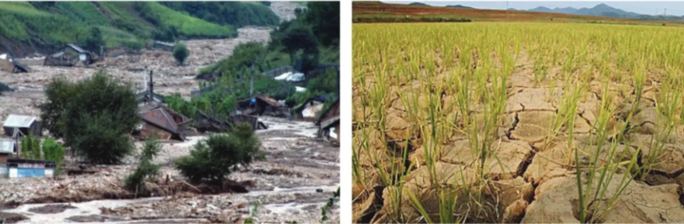
tsunamis which lead to extensive damage. For example, between August 29 and September 2, 2016, downpour in Hamgyung-bukdo led to floods so that hundreds of deaths and more than 60,000 flood victims were reported by Chosun Central Broadcasting (Fig. 1a).

Damage from cold wave and heavy snowfall in North Korea occurred between December and February of each year. In the case of heavy snowfall, Gangwon-do was damaged in February 2011 causing

serious damage to agricultural land and economy.

Residents in Yangkang-do near Baekdu Mountain suffered the most from the cold wave in 2012. The damage caused by cold waves was greater in areas where infrastructure were not equipped properly in North Korea such as resident protection facilities and social safety nets. The drought throughout North Korea was occurred mainly from March to June. The number of drought occurrences was higher in Hwanghae-do Fig. 1. Damage from Natural Disasters in North Korea (a) flood in 2016 and (b) drought in 2015.

Table 3. Natural disaster occurrence status in North Korea (2001~2017) Typhoon

and Strong

Wind Downpour Flood Landslide Cold Wave and Heavy Snowfall

Drought and Heat Wave

Sandy

Dust Earthquake Total occurrence) (Co-

2001 1 2 1 2 3 3 1 1 14  (5)

2002 5 3 1 1 0 0 3 8 21  (7)

2003 0 1 0 1 0 0 0 0 2  (1)

2004 1 5 2 1 1 0 8 6 24  (4)

2005 2 4 1 1 0 0 8 5 21  (6)

2006 1 3 2 2 0 0 1 4 13  (6)

2007 2 2 1 0 0 0 4 8 17  (3)

2008 2 1 1 0 0 0 1 12 17  (3)

2009 0 1 0 1 1 0 0 14 17  (1)

2010 3 4 4 0 2 0 0 10 23  (7)

2011 4 5 2 1 3 1 11 10 37  (8)

2012 3 5 5 2 2 1 0 7 25 (10)

2013 0 1 1 1 1 0 0 7 11  (2)

2014 0 0 0 0 0 1 1 9 11  (0)

2015 1 2 2 0 0 1 0 3 9  (4)

2016 1 2 1 2 1 1 0 1 9  (4)

2017 0 0 0 3 0 1 0 9 13  (2)

Total 26 41 24 18 14 9 38 114 283 (73)

(6)

than in other areas. From early March 2015, there was a drought throughout North Korea known as one of the worst droughts, which continued until June (Fig. 1b).

The results of the investigation of natural disasters in North Korea were reclassified into eight types (Table 3). In addition, the natural disaster occurrence status was arranged by region (Table 4).

3. Methodology

1) NTIS-based Technology Investigation and Classification

In this study, the current state of science and technology related to natural disasters in South Korea was analyzed to set a direction for inter-Korean cooperation with natural disasters. The National Science & Technology Information Service (NTIS) was used to investigate the status of research and development projects related to natural disaster related technology in South Korea (NTIS, 2019). The NTIS is a national science and technology knowledge information portal operated by the Ministry of Science,

Technology and Information; it includes information on projects, researchers, research facilities, equipment, and performance. The projects that have been performed in the last 10 years (2008 ~ 2017) were collected and used as analysis data for a general review.

To investigate science and technology related to natural disaster, related projects were selected first.

Research and development projects were classified through the primary keyword (natural disaster, disaster, safety, etc.) and natural disaster type. Finally, 65 natural disaster-related projects were selected and classified by disaster type. The types of disasters were classified into 8 types according to the types of basic laws in Korea and the natural disaster trends in North Korea, as mentioned above.

2) Priority Evaluation

The current status of technology research and development related to natural disasters in South Korea was selected and classified through NTIS investigation based on the eight predefined natural disaster types. A total of 65 technologies related to natural disasters were classified and a maximum of 10 technologies were Table 4. Regional natural disaster occurrence status in North Korea (2001~2017)

Typhoon and Strong

Wind Downpour Flood Landslide Cold Wave and Heavy Snowfall

Drought and Heat Wave

Sandy

Dust Earthquake

Total occurrence) (Co-

Hwanghae-namdo 16 20 10 7 2 5 5 16 81  (35)

Hwanghae-bukdo 17 22 13 10 0 5 4 49 120  (40)

Gangwon-do 16 22 13 9 3 2 1 8 74  (41)

Pyeongyang-si 8 12 5 5 3 2 5 3 43  (18)

Nasun-si 3 2 2 1 0 0 0 0 8   (6)

Nampo-si 3 3 3 2 0 2 2 2 17   (7)

Pyungan-namdo 10 22 13 11 0 2 5 11 74  (37)

Pyongan-bukdo 6 12 8 4 0 2 4 1 37  (18)

Hamgyong-namdo 7 16 13 9 0 1 2 10 58  (29)

Hamgyung-bukdo 5 5 3 4 1 0 1 9 28  (13)

Jagang-do 1 1 1 0 0 0 4 1 8   (2)

Yanggang-do 2 3 2 2 0 1 3 0 13   (6)

Others 0 1 1 0 6 3 30 4 45   (1)

Total 94 141 87 64 15 25 66 114 581 (245)

(7)

selected for each type. To evaluate the priorities of applying the selected natural disaster-related technology to the entire North Korea area, the technological prowess and importance of the technology were assessed for each technology.

The priority evaluation was conducted by calculating the technological prowess and the importance evaluation for the scenario that considered the whole region of North Korea. Evaluation criteria and scales were defined according to Table 3; three subcriteria of technological prowess and two subcriteria of importance of the technology were shown. A total of five subcriteria were used for the evaluation with quantified values. Finally, based on the results of the evaluation of each technology, priorities were determined according to the weights (Table 5).

(1) Evaluation of technological prowess

An evaluation of technological prowess of technology research and development related to natural disasters was given on a 9-point scale for the three evaluation subcriteria: 1) natural disaster monitoring, 2) establishment of research infrastructure such as database construction, and 3) integrated management of natural disasters.

First, the monitoring technology is considered to have a high level of importance according to the utilization of the natural disaster field, which was evaluated on a 9-point scale. Second, since infrastructure construction is the center of the application of technology, it is considered that the technical power of data is high according to the degree of relevance of basic database construction such as construction of spatial information

related to natural disasters. Finally, the possibility of integrated use was evaluated on a 9-point scale according to the evaluation standards.

(2) Evaluation of importance through focus group interview

The importance of the research and development of technologies related to natural disasters was evaluated based on the results of focus group interviews. Focus group interviews were conducted with 17 experts in the field of natural disasters for three weeks starting on October 12, 2018. The selection of experts was made in the process of investigating research papers and related projects on natural disasters in North Korea.

Also, researchers from the NTIS research project described above were selected. Specifically, interviews were conducted focusing on the application of technology considering the characteristics of each region. To derive the necessary technology, interview items were divided and interviews were performed based on the scenario of applying technology to the whole region of North Korea. Based on the results of the focus group interview, the importance was evaluated quantitively considering two subcriteria: 1) effectiveness and 2) urgency. First, the necessity and impact of the current inter-Korean natural disaster cooperation was assessed on a 9-point scale to determine the effectiveness, according to the scores measured in the focus group interview. In addition, the urgency was assessed on a 9-point scale based on the opinions presented in the focus group interviews and recent occurrences of natural disasters in North Korea.

Table 5. Priority Evaluation Standards

Criteria Subcriteria Weight Evaluation Standards

9 7 5 3 1

Technological Prowess

Monitoring 40%

Relevant Very Relevant Moderate

Relevant Somewhat

Relevant Not Relevant Infrastructure 40%

Integrated Management 20%

Importance Effectiveness 60% Very

Important Important Moderate

Important Somewhat

Important Not Important

Urgency 40%

(8)

4. Results

Considering the current situation of North Korea which lacks sufficient technology related to natural disasters, the evaluation of technical technological prowess and importance were conducted. Specifically, an evaluation of technological prowess was carried out through three evaluation subcriteria, reflecting the possibility of occurrence monitoring, establishment of a research infrastructure such as database construction, and the integrated management of natural disasters.

In addition, two evaluation subcriteria, effectiveness and urgency, were used to derive the importance of the technologies. Finally, based on the results of technological prowess and importance evaluation derived from subcriteria, a quadrant analysis was performed and classified into three groups according to the distribution, indicating the priority of the natural disaster technologies.

1) Evaluation Results of Technological Prowess and Importance

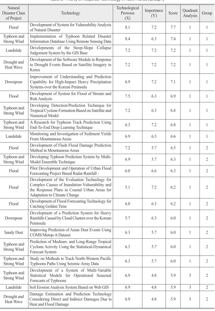
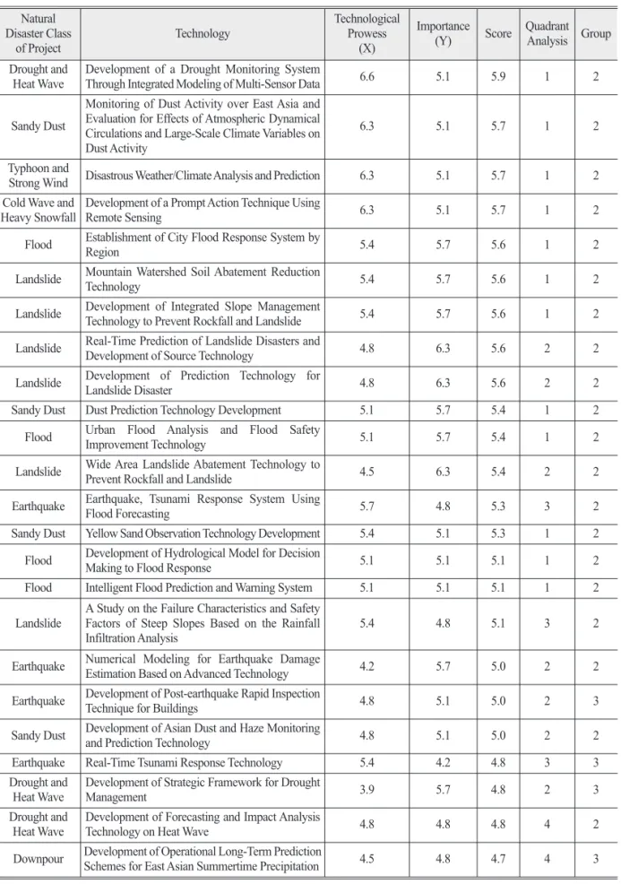
As shown in Table 6, the highest score of technological prowess among all research and development technologies was found in the application of ‘Implementation of Typhoon Related Disaster Information Database Using Remote Sensing Data’

(8.4). In addition, ‘Development of System for Vulnerability Analysis of Natural Disaster’ (8.1),

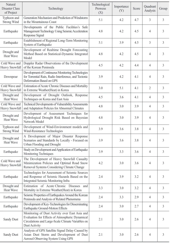
‘Development of System for Flood of Stream and Risk Analysis’ (7.5) were also given high technological prowess scores. In the case of South Korea, as well, due to the high level of damage caused by water hazards among the natural disaster types, it is analyzed that the technological prowess ranking of water hazards related technology is high. On the other hand, natural disasters involving dust had the lowest score, with a score of 2.1 given to ‘Monitoring of Dust Activity Over East Asia and Evaluation for Effects of Atmospheric Dynamical Circulations and Large-Scale Climate Variables on

Dust Activity’ and ‘Analysis of GPS Satellite Signal Delay Caused By Asian Dust Storm and Development of Dust Aerosol Observing System Using GPS.’

Outcomes of the evaluation of the importance of research and development technology for the whole region of North Korea include ‘Development of System for Vulnerability Analysis of Natural Disaster,’

‘Development of Steep-slope Collapse Judgement System based on the GIS,’ ‘Development of software module in response to drought events based on satellite imagery in Korea,’ ‘Improvement of understanding and prediction capability for high-impact heavy precipitation systems over the Korean peninsula’ and ‘Research for Typhoon Track Prediction using an End-to-End Deep Learning Technique,’ which were given an importance evaluation score of 7.2. As with the technology prowess evaluation, ‘Monitoring of Dust Activity over East Asia and Evaluation for Effects of Atmospheric Dynamical Circulations and Large-Scale Climate Variables on Dust Activity,’ ‘Analysis of GPS Satellite Signal Delay Caused by Asian Dust Storm and Development of Dust Aerosol Observing System Using GPS’ were given the lowest score, of 3.0. The following cold wave and heavy snowfall type technologies also had a score of 3.0: ‘The Development of Heavy Snowfall Casualty Minimization Policies and Optimal Road Snow Removal Systems Considering Climate Change,’

‘Estimation of Acute·Chronic Diseases and Mortality in Extreme Weather (Heat) in Korea,’ ‘Development of Key-Technologies for Disseminating Earthquake Ground-Motion Effects,’ ‘Technical Developments of Vulnerability Assessments and Adaptation Policies for Abnormal Climates’ as well as the drought and heat wave technology ‘Development of Assessment Techniques for Hydrological Drought Risk Based on Bayesian Network Model.’

2) Priority Evaluation by Quadrant Analysis

In the previous process, total 65 natural disaster-

related projects in Table 6 were scored by numerically

(9)

Table 6. Priority of Required Technology in North Korea (Group I) Natural

Disaster Class

of Project Technology Technological

Prowess (X)

Importance

(Y) Score Quadrant Analysis Group Flood Development of System for Vulnerability Analysis

of Natural Disaster 8.1 7.2 7.7 1 1

Typhoon and

Strong Wind Implementation of Typhoon Related Disaster

Information Database Using Remote Sensing Data 8.4 6.3 7.4 1 1

Landslide Developments of the Steep-Slope Collapse

Judgement System by the GIS Base 7.2 7.2 7.2 1 1

Drought and Heat Wave

Development of the Software Module in Response to Drought Events Based on Satellite Imagery in

Korea 7.2 7.2 7.2 1 1

Downpour Improvement of Understanding and Prediction Capability for High-Impact Heavy Precipitation

Systems over the Korean Peninsula 6.9 7.2 7.1 1 1

Flood Development of System for Flood of Stream and

Risk Analysis 7.5 6.3 6.9 1 1

Typhoon and Strong Wind

Developing Detection/Prediction Technique for Tropical Cyclone Formation Based on Satellite and

Numerical Model 7.2 6.3 6.8 1 1

Typhoon and

Strong Wind A Research for Typhoon Track Prediction Using

End-To-End Deep Learning Technique 6.3 7.2 6.8 1 1

Landslide Monitoring and Investigation of Sediment Yields

From Mountainous Areas 6.9 6.3 6.6 1 1

Flood Development of Flash Flood Damage Prediction

Method in Mountainous Areas 7.2 5.7 6.5 1 2

Typhoon and

Strong Wind Developing Typhoon Prediction System by Multi-

Model Ensemble Technique 6.9 5.7 6.3 1 2

Flood Pilot Development and Operation of Urban Flood

Forecasting Project Based Radar-Rainfall - 6.0 6.6 6.3 1 2

Flood

Development of the Evaluation Technology for Complex Causes of Inundation Vulnerability and the Response Plans in Coastal Urban Areas for Adaptation to Climate Change

5.1 7.2 6.2 1 2

Flood Development of Flood Forecasting Technology for

Catching Golden Time 6.0 6.3 6.2 1 2

Downpour Development of a Prediction System for Heavy Rainfalls Caused by Cloud Clusters over the Korean

Peninsula 5.7 6.3 6.0 1 2

Sandy Dust Improving Prediction of Asian Dust Events Using

COMS/Metop-A Dataset 6.3 5.7 6.0 1 2

Typhoon and Strong Wind

Prediction of Medium- and Long-Range Tropical Cyclone Activity Using the Statistical-Dynamical

Forecast System 6.3 5.7 6.0 1 2

Typhoon and

Strong Wind Study on Methods to Track North-Western Pacific

Typhoons Paths Using Seismic Array Data 6.3 5.7 6.0 1 2

Typhoon and Strong Wind

Development of a System of Multi-Variable Statistical Models for Operational Seasonal

Forecasts of Typhoons 6.9 4.8 5.9 3 2

Landslide Soil Erosion Analysis System Based on Web GIS 6.9 4.8 5.9 3 2

Drought and Heat Wave

Damage Estimation and Prediction Technology Considering Direct and Indirect Damages Due to

Heat and Flood Damage 6.9 4.8 5.9 3 2

(10)

Table 6. Continued Natural Disaster Class

of Project Technology Technological

Prowess (X)

Importance

(Y) Score Quadrant Analysis Group Drought and

Heat Wave Development of a Drought Monitoring System

Through Integrated Modeling of Multi-Sensor Data 6.6 5.1 5.9 1 2

Sandy Dust

Monitoring of Dust Activity over East Asia and Evaluation for Effects of Atmospheric Dynamical Circulations and Large-Scale Climate Variables on Dust Activity

6.3 5.1 5.7 1 2

Typhoon and

Strong Wind Disastrous Weather/Climate Analysis and Prediction 6.3 5.1 5.7 1 2 Cold Wave and

Heavy Snowfall Development of a Prompt Action Technique Using

Remote Sensing 6.3 5.1 5.7 1 2

Flood Establishment of City Flood Response System by

Region 5.4 5.7 5.6 1 2

Landslide Mountain Watershed Soil Abatement Reduction

Technology 5.4 5.7 5.6 1 2

Landslide Development of Integrated Slope Management

Technology to Prevent Rockfall and Landslide 5.4 5.7 5.6 1 2

Landslide Real-Time Prediction of Landslide Disasters and

Development of Source Technology 4.8 6.3 5.6 2 2

Landslide Development of Prediction Technology for

Landslide Disaster 4.8 6.3 5.6 2 2

Sandy Dust Dust Prediction Technology Development 5.1 5.7 5.4 1 2

Flood Urban Flood Analysis and Flood Safety

Improvement Technology 5.1 5.7 5.4 1 2

Landslide Wide Area Landslide Abatement Technology to

Prevent Rockfall and Landslide 4.5 6.3 5.4 2 2

Earthquake Earthquake, Tsunami Response System Using

Flood Forecasting 5.7 4.8 5.3 3 2

Sandy Dust Yellow Sand Observation Technology Development 5.4 5.1 5.3 1 2

Flood Development of Hydrological Model for Decision

Making to Flood Response 5.1 5.1 5.1 1 2

Flood Intelligent Flood Prediction and Warning System 5.1 5.1 5.1 1 2

Landslide A Study on the Failure Characteristics and Safety Factors of Steep Slopes Based on the Rainfall

Infiltration Analysis 5.4 4.8 5.1 3 2

Earthquake Numerical Modeling for Earthquake Damage

Estimation Based on Advanced Technology 4.2 5.7 5.0 2 2

Earthquake Development of Post-earthquake Rapid Inspection

Technique for Buildings 4.8 5.1 5.0 2 3

Sandy Dust Development of Asian Dust and Haze Monitoring

and Prediction Technology 4.8 5.1 5.0 2 2

Earthquake Real-Time Tsunami Response Technology 5.4 4.2 4.8 3 3

Drought and

Heat Wave Development of Strategic Framework for Drought

Management 3.9 5.7 4.8 2 3

Drought and

Heat Wave Development of Forecasting and Impact Analysis

Technology on Heat Wave 4.8 4.8 4.8 4 2

Downpour Development of Operational Long-Term Prediction

Schemes for East Asian Summertime Precipitation 4.5 4.8 4.7 4 3

(11)

Table 6. Continued Natural Disaster Class

of Project Technology Technological

Prowess (X)

Importance

(Y) Score Quadrant Analysis Group Typhoon and

Strong Wind Generation Mechanism and Prediction of Windstorm

in the Mountainous Coast 5.1 4.2 4.7 3 3

Earthquake Developments of the Public Facilities’s Safe Management Technology Using Seismic Acceleration

Response Signal 4.8 4.2 4.5 4 3

Earthquake Establishment of Regional Long-Term Monitoring

System of Earthquake 5.1 3.9 4.5 3 3

Drought and Heat Wave

Development of Realtime Drought Forecasting Method Based on Statistical-Dynamic Integrated

Model 4.8 4.2 4.5 4 3

Cold Wave and

Heavy Snowfall Doppler Radar Observations of the Development

of the Korean Peninsula 4.5 4.2 4.4 4 3

Downpour Development of Continuous Monitoring Technologies for Torrential Rain, Radio Interference, and Tectonic

Deformation Based on GPS 3.9 4.2 4.1 4 3

Cold Wave and

Heavy Snowfall Estimation of Acute·Chronic Diseases and Mortality

in Extreme Weather(Heat) in Korea 3.0 5.1 4.1 2 3

Drought and

Heat Wave Development of Drought Outlook, Response

Techniques on Korea and East Asia 4.5 3.6 4.1 4 3

Cold Wave and

Heavy Snowfall Technical Developments of Vulnerability Assessments

and Adaptation Policies for Abnormal Climates 4.8 3.0 3.9 4 3

Drought and Heat Wave

Development of Assessment Techniques for Hydrological Drought Risk Based on Bayesian

Network Model 4.8 3.0 3.9 4 3

Typhoon and

Strong Wind Development of Wind-Environment models and

Wind-Resistance Technologies 3.9 3.6 3.8 4 3

Drought and Heat Wave

A Development of Major Disaster Response Scenarios and Standards by Locally - Focused on

Urban Flooding and Drought 3.9 3.6 3.8 4 3

Earthquake Study on Development and Application of Earthquake

Monitoring Techniques 3.9 3.3 3.6 4 3

Cold Wave and Heavy Snowfall

The Development of Heavy Snowfall Casualty Minimization Policies and Optimal Road Snow

Removal Systems Considering Climate Change 4.2 3.0 3.6 4 3

Earthquake Technologies for Assessment of Seismic Sources and Response of Seismic Hazards Based on the

Integrated Seismic Monitoring Infra 2.4 3.9 3.2 4 3

Drought and

Heat Wave Estimation of Acute·Chronic Diseases and

Mortality in Extreme Weather(Heat) in Korea 3.3 3.0 3.2 4 3

Earthquake Seismic Properties of Earthquakes Around the Korean

Peninsula and Analysis of Related Phenomena 2.4 3.3 2.9 4 3

Earthquake Development of Key-Technologies for Disseminating

Earthquake Ground-Motion Effects 2.4 3.0 2.7 4 3

Sandy Dust

Monitoring of Dust Activity over East Asia and Evaluation for Effects of Atmospheric Dynamical Circulations and Large-Scale Climate Variables on Dust Activity

2.1 3.0 2.6 4 3

Sandy Dust Analysis of GPS Satellite Signal Delay Caused by Asian Dust Storm and Development of Dust

Aerosol Observing System Using GPS 2.1 3.0 2.6 4 3

(12)

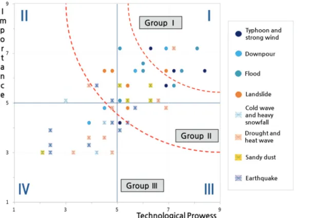
quantifying the technology prowess and importance of each technology. Based on the evaluation results of technological prowess and importance, an overall priority analysis was performed by quadrant analysis (Fig. 2).

Based on the results of the quadrant analysis, the priority of the technologies was derived which could be a basic technology in joint research and development; technologies related to natural disasters were divided into three groups according to their priorities. As a result, three broad categories of high- priority technologies were shown as: natural disaster monitoring with spatial information technology, construction of a research basis and database based on the geographic information system (GIS) and integrated management of complex natural disasters.

The priority construction of research databases from natural disaster monitoring technology in spatial information format for the whole of North Korea could be used as a generic technology in the future for joint

research and development in the area of natural disasters.

5. Discussion

In the result of this study, the natural disaster technologies that need to be applied to the North Korea region were categorized into three groups. As the quality of life in North Korea is low, those that affect survival and everyday life are given priority.

Technologies related to natural disasters that can cause serious secondary damage such as downpour and typhoons have higher priority. Therefore, regardless of the frequency of occurrence, earthquake technologies have a low significance level due to the small amount of damage. Sandy dust technologies that do not cause immediate personal injury are relatively low.

Due to the development of inter-Korean relations and the ongoing disasters in North Korea, it is necessary to prepare technical measures to reduce damage from

Fig. 2. Priority Evaluation Result by Quadrant Analysis.

(13)

disasters at the government level. It is also needed to take measures to strengthen the fundamental capability of North Korea’s disaster response. However, due to the closed attitude of North Korea, it is focused on one- off support rather than improvement of the underlying environment. Therefore, a system should be built in order to realize joint research and development. After that, it will be possible to prepare a scientific response system related to natural disasters through inter-Korean cooperation.

6. Conclusion

Research and technology that have already been performed in South Korea could be applied in North Korea region (Park et al., 2018; Lee and Lee, 2017;

Baek et al., 2017). Among these technologies, when the research and development technologies included in Group I which has a high priority are developed first, accurate natural disaster information about North Korea will be supported and a long-term support system will be provided. The results show that the three major categories of high-priority technologies are natural disaster monitoring with remote sensing and spatial information technology, construction of a research basis and database based on geographic information system (GIS) and integrated management of complex natural disasters.

Specifically, the research and development technologies included in Group I will be included as a priority, and a plan will be prepared for an integrated response to natural disasters in South and North Korea by integrating the North Korean natural disaster information base. Prediction of natural disasters through spatial analysis is very important for the reduction measures establishment. Accordingly, it is possible to establish inter-Korean cooperation by

establishing basic research infrastructure including spatial dataset that has not yet been established in North Korea. In addition, research and development technologies with lower priority were reflected in the priorities required from the medium and long-term perspectives.

With increasing natural disasters, various monitoring techniques are being developed in South Korea.

Especially, a difficult-to-reach area such as North Korea, it is necessary to use remote sensing technology.

It is also possible to continuously monitor large areas periodically. Typically, monitoring of droughts (Kim and Shim, 2017) and geological disasters (Hervás et al., 2017) such as landslides using optical satellite images has been performed. A flood monitoring study was also conducted using radar satellite imagery (De Groeve, 2010).

Furthermore, establishment of an integrated research infrastructure is important for natural disaster management through cooperation with North Korea.

Due to the exclusive characteristics of North Korea, construction and management of spatial data for natural disaster technologies is difficult. It is necessary to build an infrastructure based on GIS and manage various natural disasters in an integrated way.

Since recent natural disasters tend to occur more complexly than single disasters, an integrated disaster response system should be established through spatial distribution monitoring and data accumulation using continuous remote sensing data.

As such, integration and stable exchange of

information on natural disasters could be enabled

through joint research and development. The results

of this analysis of the priorities of technology

development related to natural disasters could lead to

an expansion of application of this area of science and

technology. Furthermore, it will be possible to establish

a plan for a joint response to natural disasters.

(14)

Acknowledgements

This research was conducted at Korea Environment Institute (KEI) with support from ‘A Study on Planning Disaster Safety Research and Development Projects for Inter-Korean Exchange and Cooperation’ by Ministry of the Interior and Safety, and the Basic Science Research Program funded by the Ministry of Education (NRF-2018R1D1A1B07041203).

References

Andrew, T., V. Luca, M.F. Montserrat, and D. Brian, 2018. Global Risk Index Results 2018, Inform, EU.

Baek, W.-K., S.-H. Park, N.-K. Jeong, S.K. Kwon, W.- J. Jin, and H.-S. Jung, 2017. A Study for the Techniques and Applications of NIR Remote Sensing Based on Statical Analyses of NIR- related Papers, Korean Journal of Remote Sensing, 33(5): 889-900 (in Korean with English abstract).

De Groeve, T., 2010. Flood monitoring and mapping using passive microwave remote sensing in Namibia, Geomatics, Natural Hazards and Risk, 1(1): 19-35.

Hervás, J., J. I. Barredo, P. L. Rosin, A. Pasuto, F.

Mantovani, and S. Silvano, 2003. Monitoring landslides from optical remotely sensed imagery: the case history of Tessina landslide, Italy, Geomorphology, 54(1-2): 63-75.

IFRC, 2013. Democratic People’s Republic of Korea: Typhoon Bolaven: DREF final Report, International Federation of Red Cross and Red Crescent Societies, Geneva, Switzerland.

IFRC, 2015. Democratic People’s Republic of Korea:

Annual Report, International Federation of Red Cross and Red Crescent Societies, Geneva, Switzerland.

Kang, T.G., J. Hoon, J.S. Lee, Y.H. Park, J.M. Choo, S.H. Ham, and K.W. Jung, 2016. Data Collection for Natural Disaster Management in the Democratic People’s Republic of Korea and Cooperation Between the Two Koreas, Korea Environment Institute, Sejong, Republic of Korea (in Korean).

Kim, Y.W. and C.S. Shim, 2017. Towards an Integrated Drought Monitoring with Multi-satellite Data Products Over Korean Peninsula, Korean Journal of Remote Sensing, 33(6-1): 993-1001 (in Korean with English abstract).

Lee, K.S., 2001. Inter-Korean disaster management cooperation plan, Korea Institute for National Unification, Seoul, Republic of Korea (in Korean).

Lee, S. and M.J. Lee, 2017. Susceptibility Mapping of Umyeonsan Using Logistic Regression (LR) Model and Post-validation through Field Investigation, Korean Journal of Remote Sensing, 33(6): 1047-1060 (in Korean with English abstract).

Lee, S., S.H. Park, and H.S. Jung, 2016. Multi-temporal analysis of deforestation in Pyeongyang and Hyesan, North Korea, Korean Journal of Remote Sensing, 32(1): 1-11.

Myung, S.J., 2012. A study on constructing a cooperative system for South and North Koreas to counteract climate change on the Korean peninsula, Korea Environment Institute, Sejong, Republic of Korea (in Korean).

Myung, S.J., 2017. Environmental cooperation to improve environmental quality in North Korea through environment facility infrastructures, Korea Environment Institute, Sejong, Republic of Korea (in Korean).

NKI, North Korea Information, Ministry of Unification, http://nkinfo.unikorea.go.kr, Accessed on Sep.

28, 2018.

NLIC, National Law Information Center, Ministry

(15)

of Government Legislation, Framework Act on the Management of Disasters and Safety, http://www.law.go.kr/main.html, Accessed on Oct. 2, 2018.

NTIS, National Science & Technology Information Service, Ministry of Science and ICT, https://

www.ntis.go.kr/ThMain.do, Accessed on Feb.

9, 2019.

Park, J.W. and H.K. Oh, 2017. A Comparative

Study on the Disaster Legislations of South and North Korea, Kookmin Law Review, 30(2):

215-260.

Park, Y.Y., H.S. Lee, K.T. Kim, and K.S. Lee, 2018.

Methodology to Apply Low Spatial Resolution

Optical Satellite Images for Large-scale Flood

Mapping, Korean Journal of Remote Sensing,

34(5): 787-799 (in Korean with English abstract).

수치

Table 3.  Natural disaster occurrence status in North Korea (2001~2017) Typhoon
Table 6.  Priority of Required Technology in North Korea (Group I) Natural
Table 6.  Continued Natural  Disaster Class
+2

참조

관련 문서