Received |
21 March, 2018
Revised |6 April, 2018
Accepted |13 August, 2018
OPEN ACCESS
This is an Open-Access article distributed under the terms of the Creative Commons Attribution Non-Commercial License (http://creativecommons.
org/licenses/by-nc/4.0) which permits unrestricted noncommercial use, distribution, and reproduction in anymedium, provided the original work is
ABSTRACT
Purpose: This study intends to determine how disaster prevention characteristics of important state-designated wooden cultural properties in Gyeongsangnam-do vary according to the surrounding environments and to examine disaster prevention measures for wooden cultural properties that fit their surrounding environments accordingly. Method: The designation status and characteristics of cultural properties in Gyeongsangnam-do and Gyeongsangbuk-do were identified, and the damage status of cultural properties in Gyeongsangnam-do and Gyeongsangbuk-do was reviewed based on the history of disasters. Also, the disaster prevention environments for 58 state-designated wooden cultural properties in Gyeongsangnam-do and Gyeongsangbuk-do were analyzed separately into mountainous area, rural area and urban area, topographic characteristics were drawn. Results: For cultural properties located in urban areas, it was found that security guards were arranged properly and disaster prevention training was carried out well. In addition, access condition to the cultural properties was adequate; prompt access to such properties was possible. In rural areas, flame retardant works have been undertaken properly and many cultural properties were found to be located on a flat ground. Mountainous areas had highly inadequate access condition to cultural properties and disasters occurred most frequently in these areas in the past. Conclution: First, for wooden cultural properties located in urban areas, it is necessary to secure the self-defense fire service manpower for an initial response and reinforce the disaster prevention education. Second, for wooden cultural properties located in rural areas, prevention projects such as insect control project and disaster prevention insurance should be carried out in order to protect the cultural properties. Third, as for wooden cultural properties located in mountainous areas, it is necessary to prepare establish to reinforce self-response capability.
Keywords: Important, State-designated Wooden Cultural Properties, Disaster Prevention, characteristics
요 약
연구목적 : 본 연구는 경상남북도의 국가지정 중요목조문화재 주변 환경에 따라 방재특성이 어떻게 다 른지를 파악하고 이를 바탕으로 문화재 주변 환경에 맞는 목조문화재 방재대책을 검토하고자 한다. 연 구방법 : 연구를 위해 경상남도와 경상북도에 있는 문화재 지정 현황 및 특성을 파악하고 재난이력을
KOSDI
Original Article
경상남‧북도 국가지정 중요목조문화재 주변 환경에 따른 방재특성 분석 연구
A Study on the Analysis of Disaster Prevention Characteristics According to the Surrounding Environments of State-designated Cultural
Properties in Gyeongsangnam-do and Gyeongsangbuk-do Provinces
구원회
1ㆍ백민호
2*
Wonhoi Koo
1, Minho Baek
2*
1
Researcher, Department of Disaster Prevention, Professional Graduate School of Disaster Prevention Kangwon National University, Samcheok-si, Korea
2
Professor, Department of Fire & Disaster Prevention, Kangwon National University, Samcheok-si, Korea
*Corresponding author: Minho Baek, [email protected]
방재특성을 분석하였다. 연구결과 : 도시지역에 위치한 문화재는 안전경비인력의 배치가 적절했고 방재훈련이 잘 이루어지고 있었으며 진 입여건은 신속하게 진입할 수 있었다. 농촌지역은 방염사업이 잘 실시되어 있었고 평탄한 곳에 위치한 문화재가 많았다. 산악지역은 진입여 건이 타 지역에 좋지 않았으며 과거 재난 발생이력도 가장 많았다. 결론 : 첫째, 도시지역의 목조문화재 경우 초기 대응을 위한 자위소방대 배 치인력 확보 및 방재교육을 강화해야 한다. 둘째, 농촌지역의 목조문화재 경우 문화재 보호를 위한 방충사업, 방재보험 등의 예방사업을 실 시해야 한다. 셋째, 산악지역의 목조문화재 경우 자체적인 대응역량을 강화하기 위한 방안을 마련해야 한다.
핵심용어: 국가지정, 중요목조문화재, 방재특성, 실태조사
서 론
문화재는 조상들이 남긴 유산으로서 삶의 지혜가 담겨 있고 우리가 살아온 역사를 보여주는 귀중한 유산이며 성격, 지정여 부 및 지정주체, 재료, 형체, 귀속주체, 이동가능 여부 등 다양한 방법으로 분류되고 있다(Koo et al., 2016).
이러한 문화재는 화재뿐만 아니라 풍수해, 지진 등 다양한 재난으로 인해 피해를 입고 있다. 특히, 2016년 9월 12일 경주지 역에서 규모 5.1의 전진과 규모 5.8의 본진이 발생하여 23명의 부상자, 110억원의 재산피해가 발생하였다. 그 중 경주시는 많 은 문화재를 보유하고 있어 2016년 9월 18일 기준으로 60건의 문화재(국가지정 36건, 시도지정 및 문화재자료 24건)에 피해 가 발생하였으며 특히, 지붕과 담장 기와 탈락, 벽체 균열 등의 피해유형이 발생하였다(Koo et al., 2016). 이번 지진은 국내 기상청 관측 이래 가장 강한 지진이 발생하여 많은 국민적 관심이 쏠렸다(Kang et al., 2016). 또한 경주에서 지진이 발생하고 1년 2개월이 지난 시점인 2017년 11월 15일 포항지역에서 규모 5.4의 지진이 발생하여 많은 재산피해가 발생하였다. 특히, 문화재는 포항지역을 비롯하여 주변 지역까지 피해를 입어 총 31개소가 크고 작은 피해를 입었다. 이처럼 문화재는 주변 환 경의 특성에 따라 발생할 수 있는 재난이 달라지며 그로 인한 피해특성도 달라질 수 있다. 일예로 도시지역에 위치한 문화재 와 산악지역에 위치한 문화재에 화재가 발생할 경우 도시지역은 소방대원이 신속하게 출동을 할 수 있지만 산악지역에 위치 한 문화재는 소방차가 출동하기 전에 화재의 최성기에 이르게 되어 전소되었다.
이에 본 연구에서는 목조문화재 주변 환경에 따른 방재대책을 마련하기 위해 첫째 우리나라 중 광역단위로 가장 많은 문화 재를 보유하고 있는 경상남․북도 문화재의 지정 현황 및 특성을 살펴보았다. 둘째, 경상남‧북도의 문화재의 재난이력을 통하 여 피해 특성을 살펴보았다. 셋째 경상남‧북도에 위치하고 국보 및 보물로 지정된 목조문화재 58개소를 대상으로 주변 환경 특성을 나누어 분석하였다. 이를 바탕으로 국가지정 목조문화재 주변 환경에 맞는 방재대책을 검토하였다.
경상북도‧남도 문화재에 대한 이론적 검토
경상북도‧남도 유형별 문화재 현황
우리나라의 문화재는 다양한 기준으로 유형이 분류되고 있으며 특히, 지정권자에 따라 국가지정문화재와 시‧도 지정문화 재로 구분하는 유형을 많이 활용하고 있다. 총 12,984개소 중 광역단위에서 가장 많은 지역은 경상북도로 2,010개가 있으며 그 뒤로 경상남도(1,794개소), 서울특별시(1,703개소), 전라남도(1,200개소), 경기도(1,036개소), 충청남도(1,030개소), 전 라북도(848개소), 충청북도(766개소), 강원도(633개소), 부산광역시(433개소), 제주특별자치도(378개소), 인천광역시(262 개소), 대구광역시(260개소), 대전광역시(218개소), 광주광역시(144개소), 울산광역시(140개소), 기타(87개소), 세종특별 자치시(42개소) 순으로 분포하고 있다.
문화재를 가장 많이 보유하고 있는 경상북도는 국가지정문화재부터 시‧도지정문화재, 등록문화재 등이 있으며 그 중 문화 재 자료가 553개로 가장 많았고 그 뒤로 시‧도 유형문화재(428개소), 보물(325개소), 시‧도민속문화재(156개소), 시‧도기념 물(150개소), 사적(99개소) 등 순으로 보유하고 있다. 경상남도는 그 다음으로 많은 문화재를 보유하고 있으며 경상북도와 동일하게 문화재 자료가 615개소로 가장 많았다. 이처럼 경상남‧북도 문화재 분포에 대한 세부적인 현황은 Table 1과 같다.
Table 1. Status of Cultural Properties in Gyeongsangnam-do and Gyeongsangbuk-do by type
Classifi cation
State-designated Cultural Property City & Province-designated Cultural Property
Regis tered cultural property
Total National
treasure Treasure Historic site
Scenic site
Natural monument
State intangible
cultural property
Important folk cultural property
City &
Provincetang iblecultural property
City &
Provinceintan gible cultural
property
City &
Province monument
City &
Provincefo lk cultural property
cultural property material
Gyeong
buk 51 325 99 15 67 9 88 428 33 150 156 553 36 2,010
Gyeong
nam 11 164 51 12 44 14 12 524 33 251 21 615 42 1,794
출처 : 문화재청, 주요업무 통계자료집, 2016.08.1
경상북도‧남도 중요목조문화재 재난피해 현황
문화재는 오랜 시간동안 각종 재난을 견뎌왔기 때문에 일반건축물과 달리 재난에 매우 취약한 구조를 가지고 있다. 이에 1936년부터 2013년까지 문화재 재난피해 현황을 알아보기 위해 총 892건
1)
을 살펴보았다. 그 중 Table 2와 같이 가장 많은1) 문화재청 문화재 재난 및 안전관리 총람 보고서 인용(2014.12.08)
Table 2. Damage Status of Cultural Properties by Region (1936~2013) Classi
fication Earthquake Damage from
storm and flood Landslide Thunder bolt Fire Robbery Damage Damages by blight
and harmful insects ETC Total
Kangwon 41 6 11 1 2 61
Gyeonggi 29 1 9 15 4 1 2 61
Gyeongnam 1 51 4 33 2 19 5 115
Gyeongbuk 62 21 36 6 54 2 181
Gwangju 4 1 1 6
Daegu 1 2 2 1 6 1 13
Daejeon 2 1 1 4
Busan 3 1 2 1 7
Seoul 42 7 2 13 5 69
Ulsan 3 1 1 1 1 7
Incheon 12 1 1 1 15
Jeolnam 98 11 14 5 9 5 142
Jeolbuk 34 1 8 7 3 9 6 68
Jeju 28 1 1 3 33
Chungnam 1 32 5 14 7 7 3 69
Chungbuk 18 5 8 5 3 2 41
Total 2 460 1 1 83 146 49 123 27 892
출처 : 강원대학교, 문화재 재난 및 안전관리 총람, 문화재청, 2014.12.08
피해를 입은 지역은 경상북도로 181건(20%)의 피해가 발생하였으며 그 뒤로 전라남도가 142건(16%), 경상남도 115건 (13%), 서울특별시와 충청남도가 각각 69건(8%), 전라북도 68건(7%), 강원도와 경기도가 각각 61건(7%), 충청북도 41건 (5%), 제주특별자치도 33건(4%), 인천광역시 15건(2%), 대구광역시 13건(1%), 부산광역시와 울산광역시가 각각 7건(1%), 광주광역시 6건(1%), 대전광역시 4건(0%) 순으로 나타났다. 특히, 경상북도는 많은 문화재를 보유하고 있으며 이로 인해 피 해도 가장 많았으며 경상남도에 있는 문화재도 많은 피해가 발생한 것을 알 수 있었다. 이처럼 경상남‧북도는 피해건수가 상 위권에 속하였으며 두지역의 합친 피해건수는 전체 1/3정도를 차지할 만큼 많은 피해가 발생하였다.
또한 2016년 9월 12일에 경주지역에서 발생한 지진으로 경주지역을 중심으로 경상남‧북도 지역에 91개소의 문화재 피해 가 발생하였으며 이는 전체 문화재 피해 중 경상남‧북도가 전체 91%를 차지할 만큼 많은 피해가 발생한 것을 알 수 있다.
Table 3과 같이 경주시는 59개소로 문화재가 피해가 가장 많이 발생하였으며 그 뒤로 청도군(8개소), 영천시(6개소), 포항시(4 개소), 양산시(3개소), 밀양시(3개소), 창녕군(3개소), 경산시(2개소), 김해시(2개소), 영덕군(1개소) 순으로 피해를 입었다.
Table 3. The current status of damages to cultural properties resulting from earthquakes in Gyeong-ju by each region and
by state designationClassification State-designated cultural property City and province-designated cultural
property & Cultural property material Total Gyeongsang
buk-do
Gyeongju-si 33 26 59
Cheongdo-gun 5 3 8
Yeongcheon-si 2 4 6
Pohang-si 2 2 4
Gyeongsan-si 1 1 2
Yeongdeok-gun 0 1 1
Gyeongsang nam-do
Yangsan-si 2 1 3
Miryang-si 1 2 3
Changnyeong-gun 0 3 3
Gimhae-si 2 0 2
Total 48 43 91
출처 : 김영호, 문화재 지진재난 대응 및 복구- 9.12. 경주 지진을 중심으로-, 지진과 문화재방재 심포지엄 발표, 2016.11.16
국가지정 중요목조문화재 주변 환경 특성 검토
전국에 분포되어 있는 국가지정 중요목조문화재는 주변 환경 및 위치에 따라 문화재의 방재특성이 달라질 수 있고 재난의 유형도 달라질 수 있다. 이에 국가지정 중요목조문화재 주변 환경에 따라 산악지역, 도시지역, 농촌지역으로 나누어 특성을 검토하였다.
먼저 산악지역은 문화재 주변이 산림에 위치하고 있으며 대부분이 고립형이라고 불리어지는 문화재로 산불, 산사태, 집중 호우 등의 피해가능성이 존재하고 있다. 이 지역은 도시지역에 비해 인구, 산업밀도가 낮고 초기대응 인원이 부족할 수 있으 며 소방서 등의 외부대응인력보다 문화재 소유자의 초기대응이 필수적으로 이루어져야 한다. 산악지역의 대표적인 문화재 는 사찰문화재가 있다. 도시지역은 문화재가 도시 내 위치하고 있어 사람들의 접근이 용이하고 방화, 훼손, 태풍, 집중호우 등 피해가능성이 존재하는 지역이다. 이 지역은 인구 및 산업밀도가 가장 높은 형태로 초기대응 및 소방서 등의 외부대응인력의
접근이 용이하지만, 이용객들에 의한 훼손의 위험성에 노출되어 있다. 그리고 농촌지역은 문화재 주변이 농촌지역에 위치하고 있으 며 집중호우 등 자연재난으로 인한 피해가능성이 비교적 높은 지역이다. 이 지역도 도시지역에 비해 인구 및 산업밀도가 낮으며 고 령화된 인력이 많아 재난 발생 시 대응할 수 있는 젊은 인력이 부족하여 초기에 대응하는데 어려움이 있다.
이처럼 문화재 주변 환경에 따라 방재특성이 달라질 수 있음을 알아보기 위해 산악지역, 농촌지역, 도시지역 문화재에 대 하여 조사가 필요하여 이러한 특성에 맞는 문화재 방재대책이 검토되어야 한다. 이에 다음 Table 4는 국가지정 중요문화재의 주변 환경 특성 분류를 나타낸 것이다.
Table 4. Classification of Characteristic Surrounding Environment in Important State-designated Wooden Cultural Properties Classi
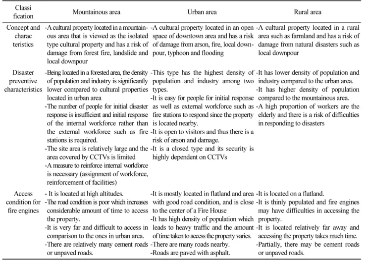
fication Mountainous area Urban area Rural area
Concept and charac teristics
-A cultural property located in a mountain- ous area that is viewed as the isolated type cultural property and has a risk of damage from forest fire, landslide and local downpour
-A cultural property located in an open space of downtown area and has a risk of damage from arson, fire, local down- pour, typhoon and flooding
-A cultural property located in a rural area such as farmland and has a risk of damage from natural disasters such as local downpour
Disaster preventive characteristics
-Being located in a forested area, the density of population and industry is significantly lower compared to cultural properties located in urban area
-The number of people for initial disaster response is insufficient and initial response of the internal workforce rather than the external workforce such as fire stations is required.
-The site area is relatively large and the area covered by CCTVs is limited -A measure to reinforce internal workforce
is necessary (assignment of workforce, reinforcement of facilities)
-This type has the highest density of population and industry among two types.
-It is easy for people for initial response as well as external workforce such as fire stations to respond since the property is located nearby.
-It is open to visitors and thus there is a risk of arson and damage.
-It is a closed type and its security is highly dependent on CCTVs
-It has lower density of population and industry compared to the urban area.
-It has higher density of population compared to the mountainous area.
-A high proportion of workers are the elderly and there is a risk of difficulties in responding to disasters
Access condition for
fire engines
- It is located at high altitudes.
-The road condition is poor which increases considerable amount of time to access the property.
-It is very far and difficult to access in comparison to the ones in urban area.
-There are relatively many cement roads or unpaved roads.
-It is mostly located in flatland and area with good road condition, and is close to the center of a Fire House
-It has high density of population which leads to heavy traffic and the amount of time taken to access the property varies.
-There are many roads nearby.
-Roads are paved with asphalt.
-It is located on a flatland.
-It is thinly populated and fire engines may have difficulties in accessing the property.
-It is located relatively far away and accessing the property takes much time.
-Partially, there may be cement roads or unpaved roads.
출처 : 강원대학교 외, 문화재 방재환경 현장조사 보고서, 문화재청, 2017.1.5
경상북도‧남도 국가지정 중요문화재 방재환경 실태조사
실태조사 개요
본 연구에서는 경상남‧북도에 있는 국가지정 중요목조문화재 58개소를 대상으로 주변 환경에 따라 산악, 농촌, 도시지역 으로 나누어 방재특성을 파악하기 위해 실태조사를 실시하였으며 이를 통해 주변 환경에 따른 문화재 방재특성을 분석하였다.
다음 Table 5는 조사 개요를 나타낸 것이며 경상남‧북도에 위치한 국가지정 중요목조문화재는 58개소로 전수조사를 실시한 자료를 바탕으로 분석하였다.
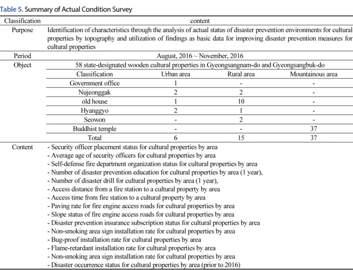
Table 5. Summary of Actual Condition Survey
Classification content
Purpose Identification of characteristics through the analysis of actual status of disaster prevention environments for cultural properties by topography and utilization of findings as basic data for improving disaster prevention measures for cultural properties
Period August, 2016 ~ November, 2016
Object 58 state-designated wooden cultural properties in Gyeongsangnam-do and Gyeongsangbuk-do
Classification Urban area Rural area Mountainous area
Government office 1 - -
Nujeonggak 2 2 -
old house 1 10 -
Hyanggyo 2 1 -
Seowon - 2 -
Buddhist temple - - 37
Total 6 15 37
Content - Security officer placement status for cultural properties by area - Average age of security officers for cultural properties by area
- Self-defense fire department organization status for cultural properties by area - Number of disaster prevention education for cultural properties by area (1 year), - Number of disaster drill for cultural properties by area (1 year),
- Access distance from a fire station to a cultural property by area - Access time from fire station to a cultural property by area
- Paving rate for fire engine access roads for cultural properties by area - Slope status of fire engine access roads for cultural properties by area
- Disaster prevention insurance subscription status for cultural properties by area - Non-smoking area sign installation rate for cultural properties by area
- Bug-proof installation rate for cultural properties by area - Flame-retardant installation rate for cultural properties by area - Non-smoking area sign installation rate for cultural properties by area - Disaster occurrence status for cultural properties by area (prior to 2016)
실태조사 결과 분석
경상북도‧남도 국가지정 중요목조문화재 58개소를 주변 환경에 따라 산악지역 37개소, 농촌지역 15개소, 도시지역 6개소 로 분류하였고 이에 대한 방재특성을 살펴보았다.
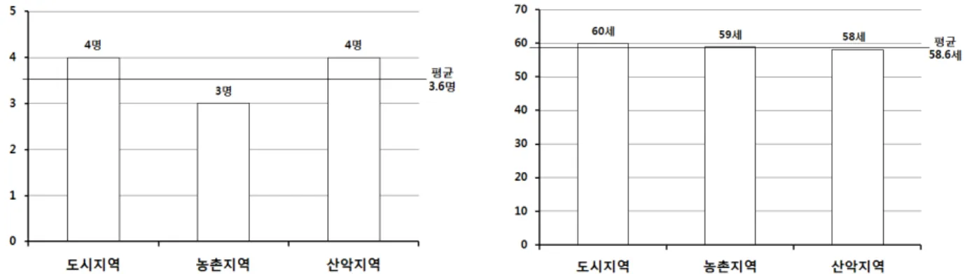
먼저 문화재 안전경비인력 배치현황을 살펴보면 도시지역과 산악지역은 4명이고 농촌지역은 3명으로 나타났다. 이는 3 가지 주변 환경의 문화재 모두 전체 평균 배치현황과는 큰 차이가 발생하지 않은 것으로 나타났다(Fig. 1). 문화재 안전경비 인력의 평균 연령은 도시지역이 60세, 그 뒤로 농촌지역 59세, 산악지역 58세 순으로 나타났다. 이는 3가지 주변 환경의 문화 재 모두 전체 평균 연령과는 큰 차이가 발생하지 않은 것으로 나타났다(Fig. 2). 문화재 자위소방대 구성 현황을 살펴보면 산 악지역이 28명으로 가장 많았고 그 뒤로 농촌지역 18명, 도시지역 10명 순으로 나타났다. 산악지역의 배치인력은 평균보다 많았고 농촌지역과 도시지역은 평균보다 배치 인력이 낮게 나타났다(Fig. 3).
다음은 1년간 문화재 방재교육 실시 현황은 산악지역이 2.7회로 가장 많았고 그 뒤로 농촌지역 2.3회, 도시지역 1.7회순으 로 나타났다. 주변 환경이 산악지역인 문화재만 전체 평균보다 많은 교육을 실시하고 있는 것을 알 수 있었다(Fig. 4). 1년간 문화재 방재훈련 실시 현황은 도시지역이 2.3회로 가장 많았으며 산악지역 2.1회, 농촌지역 1.7회 순으로 나타났다. 주변 환 경이 농촌지역인 문화재를 제외하고는 전체 평균보다 많이 실시하는 것을 알 수 있었다(Fig. 5).
문화재와 소방서와의 진입거리를 살펴보면 산악지역은 8.5km로 가장 멀었으며 그 뒤로 도시지역 2.3km, 농촌지역 2.1km 순으로 나타났다. 주변 환경인 산악지역의 문화재는 평균보다 멀어 소방차가 신속하게 진입하여 대응하는데 어려움이 예상 된다(Fig. 6). 문화재와 소방서와의 시간을 살펴보면 산악지역이 13분 18초로 가장 많은 시간이 소요되었으며 그 뒤로 도시 지역 5분 45초, 농촌지역 5분 순으로 나타났다. 거리와 비례하게 산악지역은 소방차가 진입하는데 오랜 시간이 걸려 화재 등 과 같은 재난이 발생할 경우 소방서에서 신속하게 출동하여 초기 대응하는 것은 어려울 것으로 예상된다(Fig. 7). 문화재로 접근하는 소방차 진입로 포장 현황을 살펴보면 도시지역은 100% 포장되었고 농촌지역은 93.3%가 포장되어 있었으며 산악 지역은 46%가 포장되었다. 주변 환경이 산악지역인 문화재는 산속에 위치하고 있는 곳이 대부분으로 소방차 진입도로가 비 포장도로인 경우가 더 많은 것을 알 수 있었다(Fig. 8). 문화재 소방차 진입로 경사도로 현황을 살펴보면 산악지역이 가파른 경사면이 각 문화재에 89%로 가장 많았으며 그 뒤로 도시지역 50%, 농촌지역 33.3% 순으로 나타났다. 특히, 산악지역의 특 성상 경사도로가 많은 것을 알 수 있다(Fig. 9).
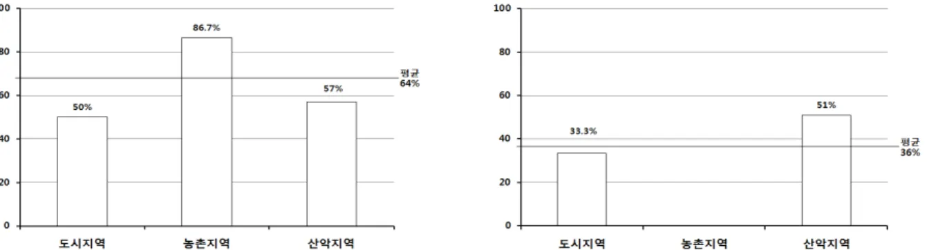
문화재 방재보험 가입 현황을 살펴보면 산악지역이 38%로 가장 높았으며 그 뒤로 도시지역 33.3%, 농촌지역은 가입이 전 무하였다(Fig. 10). 문화재 금연구역 안내표지판 설치현황을 살펴보면 도시지역에 위치한 문화재는 100% 설치되었고 그 뒤 로 산악지역 60%, 농촌지역 53.3% 순으로 나타났다(Fig. 11). 문화재 방충사업 실시현황은 도시지역이 66.7%로 가장 높았으 며 그 뒤로 산악지역 35%, 농촌지역 30% 순으로 나타났다. 특히, 주변 환경이 도시지역인 문화재만 전체 평균보다 높았으며 산악지역과 농촌지역의 문화재는 평균보다 낮은 것을 알 수 있었다(Fig. 12). 문화재 방염사업 실시현황을 살펴보면 농촌지역 이 86.7%로 가장 높았으며 그 뒤로 산악지역 57%, 도시지역 50% 순으로 나타났다(Fig. 13). 문화재 과거 재난 발생 현황은 산 악지역에 위치한 문화재가 전체 51%로 가장 많았고 그 뒤로 도시지역 33.3%이였으며 농촌지역은 발생하지 않았다(Fig. 14).
이처럼 도시지역, 농촌지역, 산악지역에 위치한 문화재가 다음과 같은 각각의 특성을 보였으며 이러한 특성을 고려한 방 재대책이 검토되어야 할 것이다.
Fig. 1. Security officer placement status for cultural properties
by areaFig. 2. Average age of security officers for cultural properties
by areaFig. 3. Self-defense fire department organization status for
cultural properties by areaFig. 4. Number of disaster prevention education for cultural
properties by area(1 year)Fig. 5. Number of disaster drill for cultural properties by area(1
year)Fig. 6. Access distance from a fire station to a cultural property
by areaFig. 7. Access time from fire station to a cultural property by
areaFig. 8. Paving rate for fire engine access roads for cultural
properties by areaFig. 9. Slope status of fire engine access roads for cultural
properties by areaFig. 10. Disaster prevention insurance subscription status for
cultural properties by areaFig. 11. Non-smoking area sign installation rate for cultural
properties by areaFig. 12. Bug-proof installation rate for cultural properties by
areaFig. 13. Flame-retardant installation rate for cultural properties
by areaFig. 14. Disaster occurrence status for cultural properties by
area(prior to 2016)이처럼 경상남‧북도에 위치한 국가지정 중요목조문화재는 도시지역, 농촌지역, 산악지역에서 각각의 특성에 나타나고 있 다. 먼저 도시지역의 문화재는 안전경비인력 배치에 적절하나 농촌지역이나 산악지역에 위치한 인력보다 연령대가 높았으 며 자위소방대의 구성인력이 낮았다. 문화재를 보호하기 위한 방재교육은 전체 평균보다 못 미쳤으며 방재훈련은 가장 많이 실시하였다. 진입여건은 산악지역의 문화재에 비해 신속하게 진입할 수 있었으며 도로의 포장율도 100%로 가장 높았고 경 사도로는 절반정도 차지하였다. 방재보험 가입율은 평균 이상이었고 금연구역 안내표지판은 100%로 관리가 잘 되어 있었 으며 방충사업도 타 주변 환경보다 높은 수치를 보여 병충해 예방을 위해 가장 노력하고 있는 것으로 나타났다. 방염사업은 절반 수준으로 실시되어 전체 평균에는 미치지 못하는 수준이었고 과거 재난 발생 현황은 1/3 정도의 문화재에서 발생한 것 을 알 수 있었다.
농촌지역의 문화재는 안전경비인력이 적게 배치되어 있었으며 방재교육은 받고 있으나 방재훈련은 평균보다 적게 실시 하였다. 소방차의 진입거리는 가장 가까운 곳에 위치하여 신속하게 접근할 수 있었으며 진입시간도 가장 짧았다. 소방차 진 입로의 포장율도 90%이상으로 대부분이 포장되어 있었으며 경사도로는 가장 적어 평탄한 위치에 문화재가 많이 위치한 것 을 알 수 있었다. 방재보험은 가입된 문화재가 없었으며 금연구역 안내판 설치도 가장 낮았으며 방충사업도 가장 낮은 수치 를 보여 관리적인 측면이 가장 부족한 것으로 나타났다. 그러나 방염사업 실시 현황은 평균이상으로 가장 높았으며 과거 재 난으로 인한 피해는 전무하였다. 이처럼 농촌지역은 도시지역의 문화재와 비슷한 진입여건을 가지고 있으나 관리적인 측면 에서는 미흡하였다.
산악지역의 문화재는 안전경비인력의 평균연령이 가장 낮았으며 방재교육 및 훈련은 평균 이상 타 주변 환경에 위치한 문 화재에 비해 잘 이루어지고 있었다. 그러나 소방차 진입여건은 도시지역과 농촌지역에 비해 거리가 멀었으며 진입 시간 또한 화재 발생에 따른 최성기 도달시간과 비슷하여 자체적인 대응이 필요한 상황이었다. 진입로 포장율 또한 절반을 미치지 못하 였으며 경사도로도 가장 많은 것으로 나타났다. 방재보험 가입에 대한 사항은 가장 높았으며 금연구역 안내표지판은 평균이 상 설치되었고 방충사업은 평균보다 낮게 실시되었다. 방염사업도 50% 이상 실시하였으며 과거 재난 발생 이력은 51%로 가 장 많았다. 이처럼 산악지역에 위치한 문화재는 외부에서 진입할 수 있는 여건이 타 주변 환경보다 좋지 않아 자체적인 역량 을 강화하기 위한 노력이 필요하고 관리적인 측면에서는 비교적 적절하게 이루어지고 있는 편이었다.
결 론
본 연구에서는 문화재 주변 환경에 따라 차별화된 목조문화재 방재대책을 마련하기 위하여 경상남‧북도에 위치한 문화재 현황을 살펴보았고 재난으로 인한 문화재 피해 현황을 조사하였다. 또한 경상남‧북도의 국보 및 보물로 지정된 목조문화재 58개소를 대상으로 전수조사를 실시하여 주변 환경에 따라 산악지역, 도시지역, 농촌지역으로 분류하였고 지역별 방재특성 을 분석하였다. 이를 바탕으로 문화재 주변 환경에 따른 방재대책을 제시하고자 한다.
첫째, 도시지역의 목조문화재는 초기 대응을 위한 자위소방대 배치인력 확보 및 방재교육을 강화해야 한다. 도시지역은 농촌 및 산악지역에 비해 유동인구가 많고 이용객에도 쉽게 오픈되어 있는 지역으로 소방서 등의 대응인력이 신속하게 초기 대응을 할 수 있다. 그러나 소방조직의 접근성이 높다는 이유로 자체적으로 대응할 수 있는 자위소방대 구성이 미흡하거나 그 인력의 방재교육이 미흡할 경우 자체적인 역량을 강화하는데 어려움이 있다. 이에 초기대응을 위한 자체적인 대응역량을 강화하기 위한 대책이 마련되어야 한다.
둘째, 농촌지역의 목조문화재는 문화재 보호를 위한 방충사업, 방재보험 등의 예방사업을 실시해야 한다. 농촌지역에 위 치한 목조문화재는 사전에 예방할 수 있는 다양한 사업이 있음에도 불구하고 다른 지역에 비해 실시현황이 낮은 것을 확인할 수 있었다. 이에 목조문화재를 재난으로부터 피해를 최소화하고 보호하기 위해 예방적인 방재대책인 방재보험, 방충사업 등 을 우선적으로 실시할 필요가 있다.
셋째, 산악지역의 목조문화재는 자체적인 대응역량을 강화하기 위한 방안이 마련되어야 한다. 산악지역의 문화재는 화재 등의 대응기관인 소방서와의 거리가 대부분 멀리 있어 신속하게 진입하기 위한 여건이 마련되어 있지 않다. 특히, 목조문화 재의 경우 화재가 발생할 경우 10~15분사이 최성기에 도달하고 빠른 시간 내 전소가 되어 문화재 가치를 상실하게 되는 경우 가 발생한다. 이에 외부에서 대응하기 위한 소방관 등의 대응인력이 접근하기 이전에 초기에 자체적으로 대응하기 위한 방안 을 마련해야 하고 이를 위해 역량을 강화해야 할 것이다. 또한 자체적인 역량을 강화하여 문화재를 보호하기 위한 대응 인력 을 확보해야 하고 특히, 방재교육 및 훈련 등을 체계적으로 실시하여 자체적으로 대응역량을 강화할 수 있도록 대책을 마련 해야 한다.
이처럼 우리나라 문화재는 주변 환경에 따라 재난의 위험성과 방재특성이 각각 다를 수 있어 그 특성에 맞는 연구가 향후 에도 지속적으로 이루어져야 할 것이다.
References
[1] Cultural Heritage Administration (2016). Major business statistics, Cultural Heritage Administration.
[2] Kang, Thomas H.-K, Jeong, S.Y, Kim, S.H, Hong, S.W, Choi, B.J (2016). “A Comparative Case Study of 2016 Gyeongju and 2011 Virginia Earthquakes.” EESK J Earthquake Eng., Vol. 20, No. 7, pp. 443-451.
[3] Kangwon National University (2014). Comprehensive disaster risk and safety management of cultural properties, Cultural Heritage Administration.
[4] Kangwon National University (2017). Research service for field investigation of disaster prevention environments for cultural properties, Cultural Heritage Administration.
[5] Kim Y.H (2016). “Countermeasures against earthquake disasters and restoration for cultural properties based on the 12 September 2016 Gyeongju earthquake.” presentation at a symposium on earthquake and other disaster prevention for cultural properties.
[6] Koo, W.h, Park, S.Y, Baek, M.H. (2016). “A study on the Actual Condition of Damages to Cultural Assets according to the Occurrence of Earthquake at Home and Abroad.” Journal of the Society of Cultural Heritage Disaster Prevention, Vol. 1, No. 2.