1. Introduction
Cloud computing is one of popular key words for rapidly emerging technologies in IT (Information Technology) application domains and business areas from its conceptualization time in 2007. It is same situation in the geo-spatial fields, with vague expectation working as a kind of killer application.
However, understanding of cloud computing or cloud services does still vary according to the different viewpoints of the concerned persons. It conjures up a short story, the blind men and an elephant, and
generates lots of jargons. Moreover, it is often compared with grid computing or utility computing.
According to NIST (National Institute of Standards and Technology: http://www.nist.gov), it is literally defined as a model for enabling convenient, on- demand network access to a shared pool of configurable computing resources that can be rapidly provisioned and released with minimal management effort or service provider interaction. Computing resources contain networks, servers, storage, applications, and services. Conceptually it can be perceived with five key characteristics including on-
Open Source Cloud Computing: An Experience Case of Geo-based Image Handling in Amazon Web Services
Kiwon Lee
Department of Information Systems Engineering, Hansung University
Abstract :In the view from most application system developers and users, cloud computing becomes popular in recent years and is still evolving. But in fact it is not easy to reach at the level of actual operations. Despite, it is known that the cloud in the practical stage provides a new pattern for deploying a geo-spatial application. However, domestically geo-spatial application imptementation and operation based on this concept or scheme is on the beginning stage. It is the motivation of this works. Although this study is an introductory level, a simple and practical processed result was presented. This study was carried out on Amazon web services platform, as infrastructure as a service in the geo-spatial areas. Under this environment, cloud instance, a web and mobile system being previously implemented in the multi-layered structure for geo-spatial open sources of database and application server, was generated. Judging from this example, it is highly possible that cloud services with the functions of geo-processing service and large volume data handling are the crucial point, leading a new business model for civilian remote sensing application and geo-spatial enterprise industry. The further works to extend geo-spatial applications in cloud computing paradigm are left.
Received May 5, 2012; Revised June 16, 2012; Accepted June 17, 2012.
†Corresponding Author: Kiwon Lee ([email protected])
geo-spatial application fields have been worked in industry or academic side. However, compared to technologies progress and substantial expectations with respect to cloud services, applications of geo- spatial field are on the pre-maturing stage, yet. Cloud computing has been partly adopted in the geo-spatial applications and linked to the geo-spatial technologies since the early 2010, but it is not prevalent till now.
As the previous works, Van Rees (2010) and Kouyoumjian (2011) mentioned that cloud computing provides opportunities for organizations to become more cost-effective, productive, and flexible to rapidly deliver new capabilities, regardless of security and privacy, being aware of the risks and concerns. They pointed out that cloud consumers are necessary to be aware of vendor lock-in when moving forward in the cloud ecosystem. Yang et al.(2010) introduced direct connection with cloud computing on implementing functions for Geospatial Cyber-infrastructure (GCI) building categorizing into observation, Spatial Data Infrastructure (SDI), web, interoperability, HPC (High Performance Computing), middleware, representation, cross domain architecture, data processing , data integration, and preservation and accessibility. Yang et al.(2011) overviewed some scenarios for the geo-spatial applications of data intensity, computing intensity, spatiotemporal intensive case, and spatial cloud computing would be new opportunities and challenges for the further an
and OneGeology, the first open-access portal to the geologic survey data of the world. Two cases are blended cloud model that uses both traditional portal service and cloud GIS technology. Bhat et al.(2011) once proposed a GIS cloud architecture with multi- layers: cloud web interface, cloud communication layer, cloud repository layer, cloud utilities layer, cloud logic layer, and cloud configuration layer.
Ramage (2011) addressed cloud computing in OGC (Open Geo-spatial Consortium, Inc.) activities. OGC recognized that the cloud plays an important role in innovation that time to market for ideas is faster when organizations reduce or to invest time and money providing basic computing infrastructure as the major trends that rate of geospatial data capture is accelerating and complexity of technical and institutional arrangements to enable data production is increasing. NASA works its own cloud computing initiative under the NEBULA cloud computing platform from 2009. Some features in cloud computing are as follows: instant-on IT infrastructure to address the gap desktops and supercomputers, automated provisioning capabilities and quick scale- up services, for scientific organizations seeking to process large datasets quickly, easily, share them with colleagues and ultimately store them securely at a good price (Hunts et al., 2010; Williams, 2011).
NASA is in top ten organizations spending on
cloud computing by United States (Kundra, 2011).
Wang et al.(2011) presented a prototype of scientific cloud for parallel satellite image processing; with clustering results with LANDSAT satellite image, they showed practical outlook for the resource re- organization and service orchestration for cloud computing. Singh et al.(2012) proposed a simple cloud solution for crime mapping using Google cloud resources, satellite data, application and GIS software, as well as crime data source in the Really Simple Syndication(RSS) feeds.
The purpose of this work is to address geo-based image handling case implemented by geo-spatial open sources in Amazon Elastic Cloud Computing (EC2), in the Amazon Web Services, and to demonstrate possibility for the further wide applications, with the result which was generated from same data sets in Kim and Lee (2012).
Moreover, the study was processed by open source so that it was a kind of practical case for open source cloud service in the geo-spatial fields.
2. Cloud computing: Trend briefing
Cloud computing is becoming one of the IT industry
buzz words. There are several variations on the definition of cloud computing. In general, cloud computing furnishes technological capabilities, commonly maintained off-premises, that are delivered on demand as a service via the Internet (Landis and Blacharski, 2010). As well as the topic of renting the physical infrastructure and applications within a shared architecture, cloud offerings can range from data storage to end-user web applications to other focused computing services. One critical difference between traditional and cloud computing basically is the scalable and elastic nature which cloud computing provides. Instead of a static system architecture, cloud computing supports the ability to dynamically scale up and quickly scale down, offering cloud consumers high reliability, quick response times, and the flexibility to handle unpredictable communication traffic fluctuations and sporadic demand.
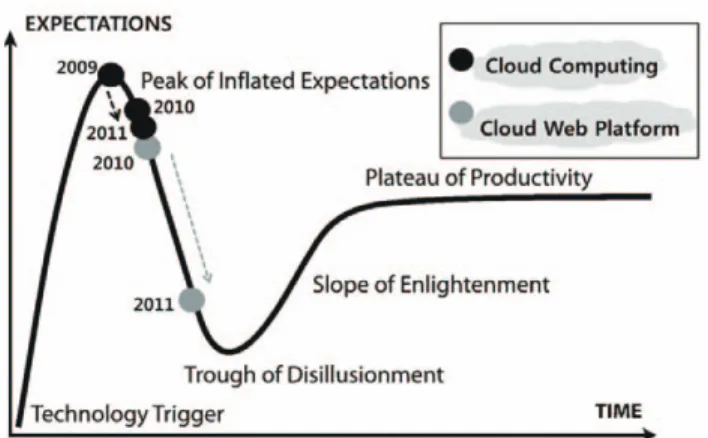
Fig. 1 shows cloud computing status in Gartner’s
hype graph in the recent three years of 2009, 2010
and 2011. Gartner’s report decided that cloud
computing already passed the peak of inflated
expectations, and ran to the stage of trough of
disillusionment. It can be interpreted that cloud
Fig. 1. Cloud computing status in Gartner’s hype graph in 2009, 2010, and 2011. Assembled and modified from Gartner’s hype graph of emerging technologies in open-accessible reports and http://en.wikipedia.org/wiki/Hype_cycle.computing is practical and concrete products to general users in most application fields. While, it is shown that cloud web platform, which is not shown in 2009, is separated in 2010, and precedes cloud computing, as of 2011. It means cloud platform is on the marketable product. Marston et al.(2011) investigated cloud computing in the business perspectives and categorized cloud industries into four types as established players, key technology providers, innovators, and enabler. IBM, Google, or Microsoft are in the established players, whereas Amazon in innovators.
Cloud computing is used in the context of three, often overlapping, delivery models. It is summarized components in the framework of Data as a Service (DaaS), Software as a Service (SaaS), Platform as a Service (PaaS), and Infrastructure as a Service (IaaS) in Fig. 2. In any case, a virtual server for virtualization, scheduling, auto-scaling, communicating, managing, and networking is common layer. SaaS is software that is deployed over the Internet and made available
computing power, storage, operating systems, or other infrastructure, delivered as off-premises, on- demand services rather than as dedicated on-site resources. Amazon EC2 is a good example.
As for the deploy model of the cloud, private cloud, community cloud, public cloud and hybrid cloud are for enterprise owned or leased in the form of on or off premises, shared infrastructure for a specific community or industry, available to the general public and provides greatest economy of scale, and composition of more than two of the above, respectively. Benefits of cloud computing are often itemized into its agility, scalability, reduced overhead, resource pooling, on-demand pricing, and accessibility. Among these, agility means the capability to deploy, deliver, standardized resources in less time, and scalability does resources adjustability on demand variation. The pay-as-you-go pricing model, as on-demand pricing, is often quite flexible when renting cloud applications or infrastructure.
Major obstacles to cloud adoption are known to security or privacy liability, performance guarantees, and absence of industry standards. Internal organizational policy is more critical issue for integration with existing systems and migration to different cloud hosting provider. Mcafee (2011) also pointed out many criticisms of cloud computing are ill-formed and overhyped, giving executes cover for
Fig. 2. Layering components in the framework of DaaS, SaaS,PaaS, and IaaS in spatial cloud computing, modified from Yang et al.(2011).
not investigating the potential of the technology, and summarized beneficial points and basic guidelines of the cloud.
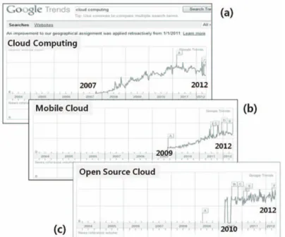
Fig. 3 represents a briefing from Google trends, as of the early 2012: (a) cloud computing, (b) mobile cloud, and (c) open source cloud. Since 2007 after the first conceptualization of cloud computing, it has been steadily regarded as one of the most interesting technologies in the mainstream IT, till now. Also it produced its derived fields such as mobile cloud and open source cloud.
3. Cloud computing and geo-based information
The cloud in the geo-spatial area has been a suggestive and prospective approach to upgrade the conventional geo-based applications in order to provide broad spectrum services to the users across the globe. The extensive use of the geo-spatial area over the decades has been regarded as good
motivation to shift it to cloud computing paradigm. It is known that a cloud computing environment for geo-based information, abbreviated in geo-spatial cloud computing, takes advantage of capabilities maintained off premises and delivered on demand as services via the Internet. Geo-spatial cloud computing services offer data storage, end-user web applications, and focused computing services. Most importantly, geo-spatial cloud computing enables collaboration for easier and faster information sharing, which often is exactly the object of service agencies. It provides a positive user experience that includes fast access to data, mashup capabilities, and new application opportunities. Some companies dealing with geo- spatial information, such as GISCloud (www.
giscloud.com) and SpatialStream (www.spatialstream.
com) are providing spatial cloud computing solutions, SaaS for geo-based data.
ESRI is promoting cloud computing and
technology important in the ArcGIS platform
(Hendrickson and Mabrouk, 2010). ArcGIS Server
can be deployed in the cloud via Amazon EC2 so that
Fig. 3. Google trends, as of the early 2012: (a) cloud computing, (b) mobile cloud, and (c) open source cloud.organizations and developers can publish and quickly deploy custom GIS mapping applications. ESRI offers ArcGIS Server on Amazon EC2 as a preconfigured solution for organizations wishing to deploy their GIS servers on established cloud infrastructures rather than use their own local infrastructures. ArcGIS Server on Amazon EC2 provides Amazon Machine Images (AMIs) for an enterprise geodatabase configured on PostgreSQL.
An AMI represents a machine image or the state of a machine once it’ s completely configured for a certain need, as a virtual image that works in the Amazon Web Services (AWS). In the website of aws.amazon.com/ko/, the keywords in AWS is a cloud Infrastructure with the components such as data centers around the world, EC2, cloud watch monitoring, cloud front for web content delivery, virtual private network, simple (S3) and block storage (EBS). ESRI (2011) estimated types of costs of clouding computing and service in every step in the application case of AWS: instance, storage and data transfer, EBS, Elastic IP address, elastic load balancing, cloudwatch monitoring.
Schüffer (2009) briefly compared AWS to Google Apps Engine (GAE), so that Google cloud was easy
to use and good for light-weight application, and Amazon cloud was more complicated to use, but full- scale solution and flexible. Further, it was noted that geo-spatial open source could facilitate Web Processing Services (WPS) in cloud computing, and full GIS packages would be SaaS. In US, federal agencies have been carried out projects for geo-data cloud services. Most cases in the public cloud are under AWS; TIGER/Line downloading service in US Census bureau, Integrated Ocean Observing System Catalog and Viewer in the National Oceanic and Atmospheric Administration (NOAA), the Global Earth Observation System of Systems (GEOSS) Clearinghouse Catalog, data service application in the United States Department of Agriculture (USDA).
On the other hands, the United States Geological Survey-Earth Resources Observation and Science (USGS EROS) Data Center adopted VMWare (http://www.vmware.com/) for cloud infrastructure.
As a cloud service, Delucchi and Neteler (2011)
reported the prototype implementation of a module to
run GRASS on a cluster for the task of the massive
spatial data analysis with MODIS. Fox (2011)
suggested that data intensive applications were
dominant in the geo-spatial areas, on the cloud
Fig. 4. Possible instance types for cloud computing and service with units of application, server, storage, and service.environment. Fig. 4 shows the possible types of cloud instance. As long as four elements of server, storage, application, and service basically consist in cloud, these four can be assembled in an instance. While, other composition style of two or three elements are also used.
4. Cloud services strategy and an example case
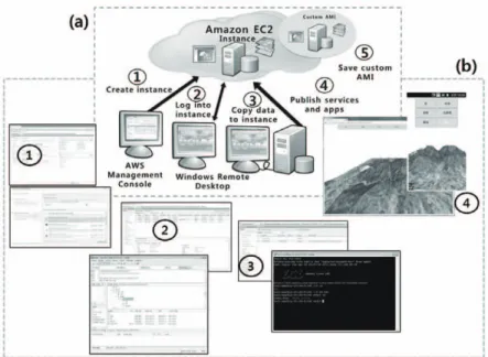
Though many IaaS platforms for developer are available, Amazon platform is used in this work, mainly because this is one of leading platforms in technology and business perspectives. Proprietary GIS software vendors such as ESRI support as a kind of target platform for cloud GIS service development (Chivite and Mabrouk, 2010). Amazon EC2 instance generating procedures with ESRI products are simply presented in Quinn et al.(2011). At the AWS management console, instance is first created. At windows remote desktop, the next steps are carried
out logging into instance and copying data to instance. After these steps, services and apps can be published. While, custom AMI is saved for the further redundant process.
Fig. 5 shows cloud computing result of Kim and Lee (2012), for simple geo-based image visualization task with actual data sets of satellite image and Digital Elevation Model (DEM), which are followed by Amazon EC2 instance generating procedures.
Kim and Lee (2012) implemented a WebGL-based visualization system of geo-based image on DEM in web and mobile environment, and it was carried out using full open sources and libraries such as Geoserver, Three.js, and PostGIS. This approach can be illustrated in Fig. 6.
Fig. 6(a) is a case of web and mobile mapping in geo-spatial open source, and Fig. 6(b) is web and mobile mapping in geo-spatial open source Amazon EC2 instance. Although this application is not fully featured cloud service, this experience gives beneficial points of cloud computing and its service:
the flexibility of application delivery and publication,
Fig. 5. (a) Amazon EC2 instance generating procedures in Quinn et al.(2011); (b) Actual data sets and geo-based image visualizationresults in Kim and Lee (2012), applied according to (a).
the accessibility of service contents in any times, and the stability of implemented products, as well as the well-known scalability issues. Furthermore, general users in cloud services do not need any software installation task, and not consider operation environment or specific software on application running. But Amazon platform is not basically free service, so that both service providers and users are subject to pay on platform usage in many ways.
Therefore, open source cloud is more cost-effective deploy model to implement public geo-based contents services.
5. Concluding remarks
Cloud computing is not something new now, and is a rapidly emerging technology that almost every industry that provides or consumes software, hardware, and infrastructure can leverage. The positive prediction on this theme is dominant with the expectations of the promise of the cloud as a
compelling argument for leveraging off-premises hardware resources and on-demand services to reduce costs and improve workflow efficiencies. Technology progress will be advanced in the areas of infrastructure commoditization, open standards, linkage to crowd sourcing, and enterprise project decentralization. Penetration to all areas of business management is also accentuated. In general, it is predicted that cloud computing is more influential in the practical processes for system design and architecture, with application migration or hybrid cloud building.
Cloud provides a new pattern for deploying a geo- spatial application: easy access to servers, extend existing systems, elastic scalability, managed infrastructure, and reduces complexity of deployment. However, there are a few domestic case applied the cloud strategy in geo-spatial application field till now, in spite of software vendor’ s promotion and many referential cases from other countries. This study is an introductory work, but presents a practical applied result, compared to the previous
Fig. 6. (a) A case of web and mobile mapping in geo-spatial open source; (b) Web and mobile mapping in geo-spatial open sourceAmazon EC2 instance.