Preparation of Soil Input Files to a Crop Model Using the Korean Soil Information System
Byoung Hyun Yoo 1 and Kwang Soo Kim 1,2*
1)1 Department of Plant Science, Seoul National University, Seoul, Korea
2 Interdisciplinary Program in Agricultural and Forest Meteorology, Seoul National University, Seoul, Korea (Received May 30, 2017; Revised September 18, 2017; Accepted September 19, 2017)
흙토람 데이터베이스를 활용한 작물 모델의 토양입력자료 생성
유병현 1 ⋅김광수 1,2*
1 서울대학교 식물생산과학부, 2 서울대학교 농림기상협동과정
(2017년 5월 30일 접수; 2017년 9월 18일 수정; 2017년 9월 21일 수락)
ABSTRACT
Soil parameters are required inputs to crop models, which estimate crop yield under a given environment condition. The Korean Soil Information System (KSIS), which provides detailed soil profile record of 390 soil series in the HTML (HyperText Markup Language) format, would be useful to prepare soil input files. Korean Soil Information System Processing Tool (KSISPT) was developed to aid generation of soil input data based on the KSIS database. Java was used to implement the tool that consists of a set of modules for parsing the HTML document of the KSIS, storing data required for preparing soil input file, calculating additional soil parameter, and writing soil input file to a local disk. Using the automated soil data preparation tool, about 940 soil input data were created for the DSSAT model and the ORYZA 2000 model, respectively. In combination with soil series distribution map at 30m resolution, spatial analysis of crop yield could be projected under climate change, which would help the development of adaptation strategies.
Key words: Korean soil information system, Soil input data, Crop model, Object, Soil series
I. Introduction
Crop models have been used to estimate crop yield under a given environmental condition. Crop models have also been used to assess the impact of climate change on crop production (Kim et al., 2012). For example, Seo et al. (2006) used the DSSAT (Decision Support System for Agrotechnology Transfer) model to identify suitable areas for soybean production in northern part of Gyeonggi province. Lee et al. (2012)
suggested that yield of rice would decrease by 23-29%
when no adaption measures, e.g., changes of a cropping season, would be used in late 21st centuries using the ORYZA 2000 model.
One of key input data to a crop model is detailed soil profile data (Gijsman et al., 2007; Varella et al., 2010).
For global simulation of crop yield, soil input files have been prepared at relatively low spatial resolution, e.g., 0.5 o . For example, Gijsman et al. (2007) and Romero et al. (2012) created a large number of soil input profiles
* Corresponding Author : Kwang Soo Kim ([email protected])
DOI: 10.5532/KJAFM.2017.19.3.174
ⓒ Author(s) 2017. CC Attribution 3.0 License.
Yoo and Kim : Preparation of Soil Input Files to a Crop Model Using the Korean Soil Information System 175
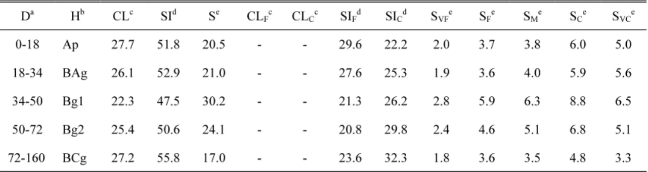
D a H b CL c SI d S e CL F c CL C c SI F d SI C d S VF e S F e S M e S C e S VC e
0-18 Ap 27.7 51.8 20.5 - - 29.6 22.2 2.0 3.7 3.8 6.0 5.0
18-34 BAg 26.1 52.9 21.0 - - 27.6 25.3 1.9 3.6 4.0 5.9 5.6
34-50 Bg1 22.3 47.5 30.2 - - 21.3 26.2 2.8 5.9 6.3 8.8 6.5
50-72 Bg2 25.4 50.6 24.1 - - 20.8 29.8 2.4 4.6 5.1 6.8 5.1
72-160 BCg 27.2 55.8 17.0 - - 23.6 32.3 1.8 3.6 3.5 4.8 3.3
a. D indicates depth (cm) b. H indicates horizon
c. CL, CL F , and CL C indicates total (< 0.002 mm), fine (< 0.0002 mm), and coarse (0.0002-0.002 mm) clay proportion of soil (%) respectively
d. SI, SI F , and SI C indicates total (0.002-0.05 mm), fine (0.002-0.02 mm), and coarse (0.02-0.5 mm) silt proportion of soil (%) respectively
e. S, S VF , S F , S M , S C , and S VC indicates total (0.05-2.00 mm), very fine (0.05-0.01 mm), fine (0.1-0.25 mm), medium (0.25-0.5 mm), coarse (0.5-1 mm), and very coarse (1-2 mm) sand proportion of soil (%) respectively
Table 1. Physical soil properties of Gagog series obtained from Korean soil information system (http://soil.rda.go.kr) based on the WISE (World Inventory of Soil Emission
potentials) database. Still, such a global data at a low spatial resolution would be limited in simulations of crop yield in Korea where small farms located in areas with complex terrains.
Soil profile data at a high spatial resolution could be obtained from the Korean Soil Information System (KSIS; http://soil.rda.go.kr). The KSIS provides soil profile records for 390 soil series that exist in Korea. Soil data of the KSIS are provided in the form of an HTML (HyperText Markup Language) document. Although these data would be useful to prepare soil input files for crop models, considerable efforts would be needed to process soil data in the HTML format.
The objective of this study was to develop a simple tool for preparation of soil input files for crop models from the KSIS, which is the Korean Soil Information System Processing Tool (KSISPT). Soil input data sets at a high spatial resolution would help spatial simulations of crop growth in Korea, which would help the development of climate change adaptation strategy in the future. In the present study, design and implementation of the tool were described using an object-oriented programming language. Then, preparation of soil input files using the soil data tool was illustrated for a crop model.
II. Materials and Methods
2.1. The Korean Soil Information System
The Korean Soil Information System allows for access to soil data through a web-based user interface.
Once a user selects an area of interest, the spatial distribution of soil series is displayed. Detailed information is also provided at the specific site where a user selected. Soil profile data can also be accessed using an identification code for the given soil series.
Properties of a specific soil series are described in text and tabular formats. Physical and chemical properties listed in the soil series data would provide information required for crop models (Table 1). For example, depth of each soil layer, contents of sand, clay and silt, and moisture retention are available in a tabular format.
Other properties including organic matter and, soil color are also provided within the table and description of each soil series, which would help preparation of soil input data for crop models.
2.2. Design of classes
A set of modules or classes was designed to parse soil
profile data for preparation of soil input files from the
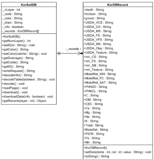
KSIS. The KorSoilDB class was designed to collect
individual soil profile data from the soil records
Fig. 1. Class diagrams of the KorSoilDB class and the KorDBRecord class, which were designed to parse an HTML document into individual soil data and to store a set of soil data by a soil layer.
provided by the KSIS using jsoup, which is a library for parsing an HTML document (Fig. 1). The KorSoilDB class was dependent on the KorDBRecord class of which a group of variables was organized to represent a single layer of soil profile data. Multiple instances of the KorDBRecord class were used as a member variable of the KorSoilDB class to store data for all of soil layer in a given soil series.
The Models class was designed to represent a prototype module for a specific model (Fig. 2). Because the format of soil input files differs by crop model, it was necessary to arrange soil profile data in a corresponding format to a model of interest. In the paradigm of object
oriented programming, an abstract class is often used to design a flexible module through inheritance. For example, a child class that has functionality specific to a given crop model, e.g., the DSSAT model, could be derived from the Models class. The writeContent function of the Models class was declared as an abstract function or method, which would be implemented in its child class.
The Hydro class was designed to estimate soil
parameters which are unavailable from the KSIS for
preparation of soil input files. About 60 types of soil
characteristics are available from the records of the
KSIS. Still, additional parameters are needed to prepare
Yoo and Kim : Preparation of Soil Input Files to a Crop Model Using the Korean Soil Information System 177
Fig. 2. Class diagrams of the classes derived from the Models class including the DSSAT class and the HydroClient class. The Hydro class was designed to estimate soil hydraulic properties.
Fig. 3. The soil input data created using the soil data tool for the DSSAT model.
soil input files to the crop model. For example, estimation of soil hydraulic properties is needed for the DSSAT and ORYZA 2000 models. The Hydro class were designed to calculate those properties using equations suggested by Saxton and Rawls (2006).
2.3. Implementation of class
The KSISPT was implemented to support preparation
of two types of crop model including the DSSAT and
ORYZA 2000 models. Member variables and member
functions of the DSSAT class, which are derived from
those of the Models class, were defined to prepare soil
input data for the DSSAT model. For example, the writeContent function of the DSSAT class had procedures to arrange soil data in a tabular shape for soil profile data (Fig. 3). The HydroClient class was also implemented to have a functionality to create precursor data for the ORYZA 2000 model.
The KSISPT was developed using Java, which is an object-oriented programming language. The user interface of the soil data tool was based on the command line as follows:
java –classpath. :<path to jsoup library> command
<path to a configuration file>, where command is the name of class for the model of interest, e.g., DSSAT or HydroClient.
This simple user interface would allow preparation of multiple soil data sets with a minimum effort. For example, a user could create a list of identification code as inputs to the soil data tool to process selected set of soil series data in a batch.
III. Results and Discussion
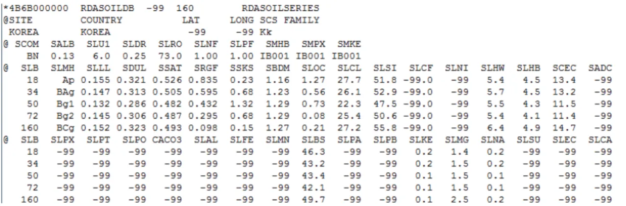
A monolithic soil input file for the DSSAT model was prepared for all of the soil series in Korea using the KSISPT (Fig. 3). Soil profile data were created for a soil series with different slopes. As a result, 940 sets of soil input data were created to take into account slopes as well as the soil series. The identification code of each soil series was derived from the same code used in the KSIS.
The KSISPT would help prepare a reliable set of soil input data without considerable labor and effort. It would be prone to error when soil profile data are parsed manually. Furthermore, considerably more time would be needed to create soil input data. The use of KSISPT would allow for the creation of soil input data for all the soil series in Korea within 4.5 minutes. It would also easy to update soil input data when the latest soil profile data become available from the KSIS.
Development of a soil input data set would help site-specific estimation of crop yield under different weather and climate conditions. For example, a map of soil identification codes could be created to access soil
profile data at a specific site. This spatial data could help impact assessment of climate change at a very high spatial resolution, e.g., 30 m, when spatial data for soil series and climate are used as inputs to crop models.
Thus, it would be merited to examine applicability of the KSISPT for a geographic information system that perform crop yield prediction at a high spatial resolution, e.g., < 1 km.
적 요
토양 변수는 작물 모형을 통한 기후변화 시나리오 조건에서의 작황 예측에 있어 중요한 환경적 요소이 다. 토양 환경 정보 시스템 (Korean Soil Information System; KSIS)에서는 390 개의 토양통에 대한 자세한 정보를 제공하고 있다. 그러나, 이러한 토양 정보는 HTML (Hyper Text Markup Language) 문서 형식으 로 제공되고 있어 작물 모형용 토양입력 자료로 변환 하는 데에 어려움이 있다. 이에 따라 KSIS의 토양정보 를 기반으로 작물모델의 토양 입력자료를 생산하는 도 구인 Korean Soil Information System Processing Tool (KSISPT) 를 개발하였다. 이 도구는 객체 지향 프로그래밍 언어인 JAVA로 작성되었으며 여러 개의 모듈로 구성되었다. 이 모듈들을 통해 각각 KSIS 웹 페이지 문서 분석, 토양 자료 저장, 추가 변수 생성, 토양 입력자료 출력 등의 기능이 구현되었다. 각 토양 통의 특성을 고려한 총 940여개의 토양 입력 자료가 생성되었다. 이 토양 자료를 KSIS에서 제공하는 30m 해상도의 토양통 공간적 분포 지도와 함께 활용된다 면, 미래 기후 조건에서 작물 생산성의 시공간적 분석 이 용이해지고 이를 기반으로 기후 변화 적응 대책 수립에 도움을 줄 수 있을 것이다.
Acknowledgement
This work carried out with the support of “Cooperative Research for Agriculture Science & Technology Development (PJ010107012017)” Rural Development Administration, Republic of Korea.
REFERENCES
Saxton, K. E., and W. J. Rawls, 2006: Soil water
Yoo and Kim : Preparation of Soil Input Files to a Crop Model Using the Korean Soil Information System 179