최근 관측된 수도권 지역 미소지진과 지진위험성
김광희1*·한민희1·김명수2·경재복3
1부산대학교 지질환경과학과, 2기상청 국가지진화산센터, 3한국교원대학교 지구과학교육과
Recent Observations of Micro-earthquakes and Its Implications for Seismic Risk in the Seoul Metropolitan Region, Korea
Kwang-Hee Kim1*, Minhui Han1, Myeongsu Kim2, and Jai-Bok Kyung3
1Department of Geological Sciences, Pusan National University, Busan, 609-734, Korea
2Korea Meteorological Administration, Seoul, 156-720, Korea
3Korea National University of Education, Chungwon, Chungbuk, 361-892, Korea
요 약: 2010년 2월 9일 수도권에서 모멘트 규모 3.1 지진이 발생했다. 수도권 지역에서는 계기지진 관측이 시작된 후 오랫동안 유감지진 보고가 없었기 때문에, 이 지진은 수도권의 지진 위험성과 위해성을 상기시키 는 계기가 되었다. 수도권은 약 2천 5백만 명의 인구밀집지역으로서 인구수 측면에서 본다면 세계에서 가장 큰 대도시 중 하나이다. 이 지진이 발생한 위치에서 규모 6.5의 지진이 발생했음을 가정하여 지진동을 시뮬 레이션 해보면, 많은 인구와 구조물의 취약성으로 인하여 서울을 포함한 수도권 지역은 매우 심각한 위해성 을 가지고 있을 것으로 생각된다. 본 연구의 동기를 제공한 시흥 지진이 피해를 야기할 수 있는 주요 지진 으로 간주될 수는 없지만, 이 지역의 역사적 지진기록과 최근 지진발생 현황에 비추어 볼 때 그 중요성을 간 과해서는 안 된다. 또한 수도권처럼 지진발생이 많지 않은 곳에서는 기존의 지진관측망으로 감시하는 지진보 다 작은 규모의 지진을 지진위험성 및 위해성 평가에 사용할 것을 제안한다.
핵심어: 지진위험성, 역사지진, 재발지진, 수도권
Abstract:
A moment magnitude 3.1 earthquake occurred in the Seoul metropolitan region (SMR), Korea, on 9 February 2010. The unexpected shaking attracted much attention and raised concerns about the seismic hazards and risks in the SMR, which was regarded as an area safe from any earthquake hazard.The SMR has a population of 25 million and is one of the largest metropolitan areas in the world. A shakemap for a scenario earthquake with magnitude 6.5 and focal depth 12 km implies that the SMR will be exposed to serious risk because of its large population and the high vulnerability of its buildings.
Although the instrumentally recorded earthquakes discussed in this article cannot be classified as major events, they should not be discounted as insignificant. Considering the low seismicity, micro-earthquakes below the magnitude of a conventional seismic network can achieve would be used to estimate background information in the evaluation of earthquake hazards and risks.
Keywords:
Seismic hazard, Historic earthquakes, Repeating earthquakes, The Seoul metropolitan regionIntroduction
A minor earthquake of magnitude MW 3.1 occurred on the outskirts of Seoul, Korea (Fig. 1). The Earth-
quake Center at the Korea Meteorological Adminis- tration (KMA) announced that the earthquake occurred on 9 February 2010 at 09:08 (18:08 local time). The earthquake was located at 37.45ºN, 126.80ºE and is called Siheung earthquake after the nearest town. The earthquake was felt widely in the Seoul metropolitan region (SMR), and it has received much attention from
*Corresponding author Tel: +82-51-510-2250
E-mail: [email protected]
the news media and the public. It was the most widely felt earthquake in the SMR since the instrumental obser-
vation in Korean peninsula since 1905 (KMA, 2016).
The shock raised concerns about seismic risks in the SMR, which includes Seoul, Incheon, and part of Gyeo- nggi-do province (Fig. 1). Demographic data from the Ministry of Interior (MOI), Korea, indicate the SMR has a population of 25 million (MOI, 2016). The region has been the economic, political, and cultural center of Korea since 1394 when the city of Seoul was designated the capital of the Chosun Dynasty (1392-1910).
Although the Siheung earthquake did not cause sig- nificant damage, it raised the awareness of the potential earthquake risks for SMR for the first time in modern times. In this research, we briefly reviewed the seis- micity of the SMR and Korean peninsula from historic and instrumental records. Then, we evaluated the sig- nificance of the earthquakes in terms of the potential seismic risk to the highly populated SMR due to the huge vulnerable exposure.
Historical Seismicity in Korea and SMR
Although damage or casualties due to earthquakes in Korea has been negligible during the past century, his- toric records suggest that the Korean peninsula has experienced several damaging earthquakes (Fig. 2). The first written record of an earthquake in Korea appeared in A.D. 2 in Samgooksagi (the Chronicles of the Three Kingdom; Chiu and Kim, 2004; Lee and Yang, 2006;
Kyung et al., 2010). Since the A.D. 2 event, numerous earthquakes have occurred that were registered in Korean historical documents. The historical earthquake catalog of Korea was compiled based on reports of felt earthquakes. Thus, records of historic earthquakes in Korea may be biased by population distribution, and many earthquakes mentioned in the earlier historic records are located in population centers of the time.
Historic records became more accurate in the Chosun Dynasty (established in 1392) owing to the centralized governing structure, higher population density and improved communication methods. Preliminary anal- ysis of catalog completeness during the Chosun Dynasty yields earthquakes with magnitude greater than
Fig. 1. (a) Seismicity and major tectonic boundaries
(red lines) near the Korean peninsula. Earthquake epicenters with magnitude greater than 4.0 since 1973 are shown (NEIC, 2016). Tectonic plates and their boundaries are adopted from Bird (2003): EU=Eurasian, NA=North America, PS=Philippine Sea, PA=Pacific.
The inset shows the Seoul metropolitan region shown
in (b). (b) Population density map near the epicenter
including Seoul, the capital city of Korea (outlined by
thick lines), and Incheon (outlined by blue broken
lines), and Gyeonggi-do (outlined by green broken
lines). The epicenter of the 9 February 2010 Siheung
earthquake is plotted by a star. There are approxi-
mately 25 million people within a 60 km radius of the
epicenter.
4.7 are well recorded.
Wada (1912) compiled 1,644 historic earthquake records, the first such compilation, from multiple sources including, but not limited to, Samgooksagi (B.C. 57-935 AD), Koryeosa (the History of Koryeo dynasty, 918-1392), and Chosunwangjosillog (the Annals of the Chosun Dynasty, 1392-1897). Musha (1951) also compiled records of historic earthquakes and volcanic activity in Korea and Japan. However, refining the his- toric earthquake catalog of Korea is an ongoing project (e.g. Chiu et al., 2004; Lee et al., 2006). Most recently, Kyung et al. (2010) compiled reports of major felt earthquakes in Korean history to produce comprehen-
sive isoseismal maps and estimated the intensity and magnitude of the corresponding events.
Although there are discrepancies in the estimated magnitudes of historic earthquakes among previous studies, it is generally accepted that the largest historic earthquake occurred in the Gyeongju area, southeastern Korea, in April 779 (Fig. 2). The magnitude of this earthquake has been differently estimated as 7.3, 6.3, and 6.7 by Chiu and Kim (2004), Lee and Yang (2006), and Kyung et al. (2010) respectively. Since the foun- dation of the Chosun Dynasty in 1392 and establish- ment of its capital to Seoul (then called Han-yang), records of felt earthquakes in the SMR have become more reliable and detailed. The temporal distribution of earthquake occurrences in the area is not even. Fig. 3 shows variations in the frequency of earthquakes per century. It is clear that the SMR has experienced seis- mically active periods during its history, including those of the 16th to 18th centuries. Such fluctuations in the temporal distribution of the number of earthquakes are not unusual in the seismicity pattern of a stable con- tinental region (e.g. Lee, 1987; Kyung et al., 1996; Lee, 1998; Li et al., 2009). Shimazaki (1984) and others sug- gested that a cyclic loading and unloading of stress exerted by the intermittent motion of the oceanic plate along the plate-margins (Nankai & Japan trenches) switches on and off the intraplate seismicity. Mogi
Fig. 2. Historic earthquake epicenters (A.D. 2-1904) in Korea (compiled by Kyung et al. 2010). The M 6.7 Gyeongju historical earthquake in 779 that caused the largest damage among the historical earthquakes in Korea is indicated by a gray star in the southeastern corner of the peninsula; the M 6.7 and M 6.4 Seoul historical earthquakes in 1518 and 1692 are shown by black stars.
Fig. 3. Temporal distribution of the historic seismicity
in Korean peninsula and SMR (outlined by the dotted
lines in Fig. 2).
(1966) proposed that the sudden decrease in the seis- micity in the Korean peninsula in early 18th century (Fig. 3) is due to the stress release caused by the occur- rence of the great 1703 and 1707 (Nankaido) interplate events along the plate boundary of the Philippine Sea plate and also by the M8 great earthquakes in Northeast China at the end of 17th century. Duration of the intraplate seismicity in the Korean peninsula prior to the 1707 interplate earthquake can be estimated as 300 years (Fig. 3). By assuming that the recurrence interval of the 1707 type earthquake along that part of plate boundary is 1000 years, Shimazaki (1984) obtained a recurrence interval of 1200 to 7800 years for an intraplate earthquake in the Korean peninsula. He assumed accumulation rate of stress disturbance in the Korean peninsula due to the cyclic loading at the plate boundary to be about 0.03 bars/year as in northeastern Japan, though it is 0.2 bars/year for Southwest Japan.
By assuming the stress drop of the intraplate event as 100 bars, Shimazaki (1984) estimated the recurrence interval. Although artificial factors that may have affected the distribution still cannot be ruled out, the seismicity trend of temporal increase (the unusual period of high seismicity) coincides with the trend in northeastern China. Hence, several seismologists sug- gested that the two areas are closely related (Mei, 1965;
Kyung et al., 1996; Lee, 1998).
Significant seismicity in the year 1518 is noticeable in the historic seismicity of the SMR. On 22 June 1518, a series of earthquakes occurred. In the historic records, local and central government authorities reported the following: “Three successive earthquakes shook the capital and its vicinity. Houses collapsed, and people stayed in the open air to protect themselves from build- ings that might collapse. Even some ramparts were demolished by the unusual shaking. Smaller but sig- nificant tremblers followed over the next several days.”
Another significant sequence of earthquakes occurred in November 1692. Strong shaking accompanied by loud sounds was reported. Kyung et al. (2010) reviewed the historic records of the earthquake sequences to map the details of the shaking and concluded that the largest magnitudes during the earthquake sequences of 1518
and 1692 were as large as 6.7 and 6.4, respectively (Fig.
2).
Repeating Micro-seismicity in SMR and Earthquake Hazard
Kim & Kim (2014) studied 2010 Siheung earthquake sequence by analyzing waveform data recorded at seis- mographic stations in and around SMR to learn more about the earthquake activity in the region. Modern seis- micity in the SMR is relatively low. Only a few earth- quakes (less than 10) of magnitude greater than 2.0 have occurred since 1990 (KMA, 2016). Because the SMR is highly populated and the earthquakes were nucleated at relatively shallow depths of 5 km to 11 km (Kim et al., 2014; KIGAM, 2016), most of them were felt widely in the area. The 2010 Siheung earthquake was the largest event among these.
Waveform cross-correlation technique, which has been extensively applied to different regions of tectonic settings (e.g. Gibbons et al., 2006), has been employed in order to detect low magnitude seismic events around the 2010 Mw 3.1 Siheung earthquake source area (Kim et al., 2014). Kim & Kim (2014) identified 10 small earthquakes during 2007 and 2011. Note that only one event was reported in the KMA Earthquake Bulletin during the period.
Evaluation of earthquake hazards and risks for an area requires carefully constrained input parameters including a seismic source zone, the seismicity rate, ground-motion attenuation relations, and slip rates of faulting. Imperfect knowledge of these parameters degrades the accuracy and usefulness of evaluation results. It would be necessary to wait a considerable number of years until reliable information could be gathered. An even longer time period is necessary to accumulate sufficient materials in the area of low seis- micity rate. As an alternative to the undesirable cir- cumstances, micro-earthquakes, below the magnitude of a conventional seismic network can achieve, would be used to estimate background information in the eval- uation of earthquake hazards and risks.
Discussions and Conclusions
It is important to understand the temporal and spatial activity of the responsible faults to have a thorough understanding of the observed seismicity and associated hazards. Geological studies in the Korean peninsula indicate that there are more than 450 faults, most of which have been proposed based on surface geologic observations from topographic maps, aerial photographs and field geological surveys (e.g. Choi, 2011). While the active faults in southeastern Korea are well studied and thought to be capable of causing earthquakes as large as magnitude 6.5 to 7.3 (e.g. Kim et al., 2007;
Kyung, 2010; Son et al., 2015), those in central western Korea including SMR have not been mapped well.
Although details of the active faults in the Korean pen- insula is an open question, two faults with lengths up to 2 km have been identified near the epicenter of the 2010 Siheung earthquake in the 1:50,000 scale Geological Map of Korea (KIGAM, 1975). They are located approximately 4-5 km southeast of the epicenter of the 2010 Siheung earthquake. Both identified faults strike in WNW-ESE directions, which is consistent with the direction of precisely determined earthquake hypocen- ters and also one of the nodal planes determined by the waveform inversion (Kim et al., 2014). No further information about the faults is available, and they have not yet been given names.
It is important to reveal any speculations based on the newly available source information. It is worthwhile to note the epidemic earthquake sequence of June 1518 in the historic earthquake record of Korea. The earthquake sequence started with a magnitude 6.7 event and lasted for at least the following four months (Kyung et al., 2010). During the earthquake sequence, more than 30 earthquakes were large enough to be felt and published in the Annals of the Chosun Dynasty. The magnitudes of several large aftershocks were as large as 5.2 (Kyung et al., 2010). These are consistent with the generally conceived mainshock–aftershock magnitude relation- ship, which states that the magnitude of the largest after- shock is about 1.2-1.4 units smaller than that of the mainshock (Båth, 1979). Because the area has expe-
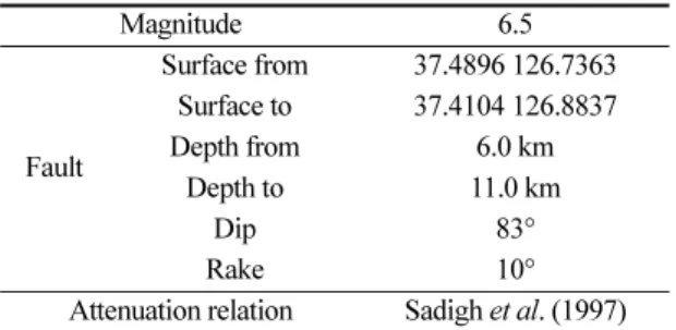
rienced several damaging earthquakes in its history, including the earthquake sequence of 1518, we cal- culated a shakemap for a scenario earthquake in the region using the OpenSHA (2013). We assumed a mag- nitude 6.5 earthquake occurring at the hypocenter of the 2010 Siheung earthquake. We assumed a slightly lower magnitude to account for the different results in mag- nitude estimations in previous historic earthquake stud- ies. We also assumed that the focal mechanism of the scenario earthquake is the same as that of the 2010 Siheung event. The surface rupture length of the sce- nario earthquake is estimated to be 15.7 km based on the empirical relationship proposed by Wells and Cop- persmith (1994). The strong motion-attenuation rela- tionship, which represents a comprehensive trend of ground shaking with distance, is another influential parameter, and we adopted the attenuation relationship proposed by Sadigh et al. (1997), which was also used by Kang et al. (2007). Site responses, which predict the amplification of ground shaking resulting from the nature of the site condition, including the material prop- erties of the shallow subsurface and the geometry of the target area (e.g., sedimentary basin), are also required for the estimation of a shakemap for a scenario earth- quake. We adopted the Vs30 map by Wald and Allen (2007) to generate a ground-motion amplification map.
For any details not discussed here, readers are kindly asked to refer the OpenSHA (2013). The shakemap completed under the prescribed assumptions (also sum- marized in Table 1) is presented in Fig. 4. The areas highlighted as red patches in the shakemap are expected to experience severe ground shaking as large as 0.43 g.
Table 1. Input parameters of the scenario earthquake source and regional attenuation relation used for a shake map
Magnitude 6.5
Fault
Surface from 37.4896 126.7363 Surface to 37.4104 126.8837
Depth from 6.0 km
Depth to 11.0 km
Dip 83°
Rake 10°
Attenuation relation Sadigh et al. (1997)
It is noteworthy that the Gwangmyung high-speed train station and Gimpo International Airport, two important infrastructures, are expected to experience ground shak- ing greater than 0.4 g and 0.25 g, respectively. The cen- tral Seoul area is also expected to experience very strong ground shaking. It is hard to evaluate the reli- ability of the shakemap shown in Fig. 4, because many assumptions were made to derive the map, even though these assumptions were based on the best available
information. Even so, stronger ground motions than the shakemap indicates can be expected because our assumptions were rather conservative. For example, our assumptions of the attenuation relationship and site con- dition would have underestimated ground-motion amplification at many sites.
This work was motivated mainly by a small but strong shaking earthquake that occurred at one of the most populated regions in the world, the Seoul met- ropolitan region (SMR) in Korea. Located away from any plate boundaries, the Korean peninsula is regarded as a typical region of intraplate seismicity. Recent review on damaging historic earthquakes in SMR revealed the largest potential earthquake in the area is MMI (Modified Mercalli Intensity) VIII-IX with a long recurrence interval of about 1400-1500 years (Kyung, 2012). Large earthquakes in the SMR and Korean pen- insula have been rare during modern instrumental earth- quake recording that began 1905. Considering all these aspects, it is generally accepted that the seismic hazard in the Korean peninsula, including the SMR, is rela- tively low. Nevertheless, 1900 years of historic earth- quake records indicate that the peninsula has repeatedly experienced damaging earthquakes, although they are infrequent compared to active areas such as Japan or California. Studies of historic earthquake records indi- cate that the SMR is one of the most seismically active regions in Korea; however, this estimation is subject to a significant amount of uncertainty as a result of the inherent nature of historic earthquake studies.
Earthquake risk, which is a combination of the level of seismic hazards, the number of people, and the amount of property that are exposed to the seismic haz- ards, and how vulnerable these people and property are to the hazards, may be another aspect. Obviously, the risk in SMR is very high, because the area is highly populated and concentrated with critical infrastructures.
There are 25 million people in the SMR, and 48.4% of the gross domestic product of Korea originates from the SMR. The earthquakes mentioned in the study, includ- ing the one in 2010, were minor and did not cause any damage, but if an earthquake of magnitude 5 or larger were to occur, it is expected that serious damage would
Fig. 4. Shakemap of a magnitude 6.5 scenario
earthquake that may occur at the 9 Feb. 2010
Siheung earthquake epicenter. The epicenter of the
scenario earthquake and location of the fault rupture
are marked by a star and white, thick solid line,
respectively. The white square and diamod show the
locations of the two major structures discussed in the
text. SMR is outlined by thick grey line. Black solid
lines show the location of faults mapped in the
Geological Map of Korea. The OpenSHA application
was used to generate the shakemap. Focal
mechanism of the scenario earthquake is assumed to
be the same as that of the Siheung event, which is
adopted from Kim and Kim (2014). See text for details
of the conditions for generating the shakemap.
result because of the centralized infrastructures, large population directly exposed to the earthquake, and the vulnerable and unprepared nature of the society.
According to a press release by the National Emergency Management Agency (NEMA) of Korea, the SMR would experience more than 110,000 casualties if a magnitude 6.5 earthquake were to occur in SMR. From the point of view of seismic risk, because significant damaging earthquakes have occurred repeatedly in the SMR through history, the potential for seismic risk in the SMR should not be overlooked.
Acknowledgements
We thank the staff at Korea Meteorological Admin- istration and Korea Institute of Geoscience and Mineral Resources who provided us with continuous waveform data from their seismographic network stations. We would like to thank Dr. Won-Young Kim of Lamont- Doherty Earth Observatory of Columbia University for his invaluable comments to the earlier manuscript. This work was supported by a 2-Year Research Grant of Pusan National University.