UIL:A Novel Indexing Method for Spatial Objects and Moving Objects
Xuguang Huang * Sung-Ha Baek ** Dong-Wook Lee **
Weon-Il Chung *** Hae-Young Bae ****
Abstract Ubiquitous service based on Spatio-temporal dataspaces requires not only the moving objects data but also the spatial objects. However, existing methods can not handle the moving objects and spatial objects together. To overcome the limitation of existing methods, we propose a new index structure called UIL (Union Indexing Lists) which contains two parts: MOL (Moving Object List) and SOL (Spatial Object List) to index the moving objects and spatial objects together. In addition, it can suppose the flexible queries on these data. We present the results of a series of tests which indicate that the structure perform well.
Keywords : Index, Inverted List, Spatial Object, Moving Object, Ubiquitous Services
This research was supported by a grant(07KLSGC05) from Cutting-edge Urban Development - Korean Land Spatialization Research Project funded by Ministry of Construction & Transportation of Korean government.
* *
Master Student, Inha University Dept. of Computer Science and Information Engineering, [email protected]
****
Doctoral Student, Inha University Dept. of Computer Science and Information Engineering, {shbaek, dwlee}@dblab.inha.ac.kr
****
Instructor, Hoseo Universitry Dept. of Information Security Engineering, [email protected](corresponding author)
****
Professor, Inha University Dept. of Computer Science and Information Engineering, [email protected] Manuscrip received:2009.05.12 Accepted:2009.06.15
1. Introduction
A Spatio-temporal database supports not only effi- cient query processing on a large number of moving objects but also the spatial objects (e.g. maps, roads, mountains, etc.), and has numerous applications in practice. The existing studies mainly focus on retriev- ing the data of moving objects. However, nowadays, ubiquitous service based on spatio-temporal data- spaces requires not only the moving objects data but also the spatial objects and other unstructured data. In this paper, we consider maintaining an index structure for moving objects and spatial objects, where the goal is to suppose the flexible queries on spatio-temporal dataspaces.
There have been many research efforts to develop strategies for indexing and querying moving objects.
However, the existing methods for moving objects suffer from certain disadvantages. The R-tree based index [1][2][3][4][5][6] may require high management cost to track moving objects, because moving objects require frequent updates which made to an R-tree in- dex lead to deteriorated performance due to a sig- nificant amount of overhead to split and merge nodes.
Although some of methods such as STRIPES [9] are efficient to update, it has high space consumption and low query performance. The B
x-tree [10], the state- of-the-art, involves several B
+-tree indexing the order of objects on a space filling cure, which do achieve satisfactory query efficiency due to the large number of false hits.
Nonetheless, all of the existing methods above do not consider the spatial objects data together with moving objects data. They can not process the queries which required both the moving objects data and spa- tial objects data, such as “Return the cars that passed by the red building whose name is ‘National’”.
In this paper, we present a new index structure called UIL(Union Indexing Lists). The UIL consists of two main structures: Spatial Objects-List (SOL) and Moving Objects-List(MOL). The SOL is an inverted list to support robust indexing of loosely-coupled col- lections of heterogeneity spatial objects data. The MOL is a series of Moving Objects Tables (MOT) to handle the spatio-temporal data of moving objects.
Multiversion techniques used on these two structure
to produce a time and space efficient index structure,
and is particularly useful for processing various quer-
ies on spatio-temporal dataspaces.
The MOL contains a series of MOT which grows up along with the passage of time. A MOT in MOL is a table, where rows represent the spatial information and columns represent the moving objects. In each grid cell, there is a variable to record whether a mov- ing object appears in that location at that time. The SOL is an inverted list which is a two-dimensional table, where the row represents the spatial information and the column represent the keywords of geography objects. In section 4, we will introduce how the com- bination of the two structures can answer the flexible queries easily.
The rest of the work is organized as follows:
Section 2 discusses related works. Section 3 describes our indexing structure in details. Section 4 gives the algorithms for loading and supporting flexible queries.
Section 5 presents experiments evaluation and Section 6 concludes.
2. Related work
The two bodies of work most close to ours are R-tree based methods and inverted index methods.
Next, we will discuss each category in turn.
2.1 R-tree based methods
There have been many indexing methods to store and retrieve the past, current and future locations of moving objects. Our work focuses on the past and current data of moving objects, so we mainly in- troduce the works on this area.
The RT-tree[1] which adopts ideas from the R-tree[2] and TSB-tree[3] couples time intervals with spatial ranges in each node of the tree. It is inefficient that it would require a complete scan of the index, when queries are processed based on the temporal do- main as searching and splitting a node of RT-tree guided by spatial information not the temporal information.
The 3DR-tree[4] is very space-efficient and can process time interval query very efficiently, as it stores only the different object versions without re- dundant copies and the temporal attributes and the spatial attributes are tightly integrated. However, it is poor to process the query at a specify time, since all objects are indexed in a single tree and thus the query processing time depends on the total number of entries.
The HR-tree[5] construct a set of R-tree for each timestamp, and it can handle the queries of a specify
time very efficiently. For time interval queries and range queries, however, it can be very slow, as these queries require searching as many trees as the num- ber of distinct timestamps in the interval.
MV3R-tree[6] proposed by Tao and Papadias com- bines the concepts of multi-version B-trees and 3DR-tree. Although it is very efficient to deal with time interval queries and range queries, it requires more space and needs high management cost due to the combination of the MVR-tree and 3DR-tree.
2.2 Inverted List
An inverted list is a record level inverted index which contains a list of references to documents for each word. An inverted index is an index data struc- ture storing a mapping from content, such as words or numbers, to its locations in a database file, or in a document.
Recently, Xin Dong[7] proposed a new indexing structure KIL extended the inverted list to index het- erogeneous data in dataspaces. The extended inverted list KIL is a two-dimensional table, where the i-th row represents indexed keyword and the j-th column represent instance. The cell (i-th, j-th) records the number of occurrences. It is very efficiently to process keywords query and neighborhood queries. However, it only cannot handle the spatial data which contains the location information.
3. Design of Union Indexing List
In this section, we first describe the model of mov- ing objects data and spatial objects. Then the struc- ture of UIL and the details of MOL and SOL are introduced.
3.1 Various data
Our goal is to support efficient queries over moving objects data and spatial objects which are not neces- sarily semantically and ghited by existing Spatio-tem- poral database or Spatio-temporal data integrated system.
An object’s position at some time t is given by
oi=(p
1,p
2,…,p
d),which is a point in a d-dimensional
space.In this paper, we consider a moving object data
as a set of discrete manner point objects which grows
along with time. We assume that a point moves in a
two-dimensional space and our approach can be easily
expanded into a higher dimensional space. Unlike
some R-tree based method, we do not use MBR, but
instead it stores the exact sample locations of each
moving object.
Considerable work has been done on indexing static spatial objects. Probably the most popular index methods are two types: one is the cell methods, such as Quad tree[15] and K-D-B tree[16] which use the grid file to handle the point spatial data; another is R-tree, a balanced structure that clusters objects by their spatial proximity. However, all of these methods only consider the location information of spatial objects. Beside this information, there is also other unstructured information of spatial object. For exam- ple, a gray building located in No. 10 of First road and its name is “Hana” bank. To describe a building, we can not only use its geography coordinates but also use its name “Hana bank”, address <“no.10”,“first road”> and color “gray” information. How to index the spatial object using these predicate keywords and geography coordinates is a big challenge. In this pa- per, we model the spatial object as a set of tetrameric elements (ID, location, attribute, keywords) which can adapt the variety data model. And SOL proposed by this work which is an extended inverted list is used to index the various spatial data.
3.2 Data model of UIL
Formally, in UIL index structure proposed in this paper, the data of moving objects and spatial objects are modeled within grid cells.
In a three-dimensional space (X,Y,T), a trajectory of a moving object M can be presented as (x,y,t), where x=[x
0,x
n-1], y=[y
0,y
n-1] and t=[t
0,t
n-1]. And they can be divided into cells according to the sample in- terval such that: x=[x
0,x
1)U[x
1,x
2)U…U [x
n-2,x
n-1], y=[y
0,y
1)U[y
1,y
2)U…U[y
n-2,x
n-1] and t=[t
0,t
1)U[t
1,t
2)U…
U[t
n-2,t
n-1], where tn means current time.
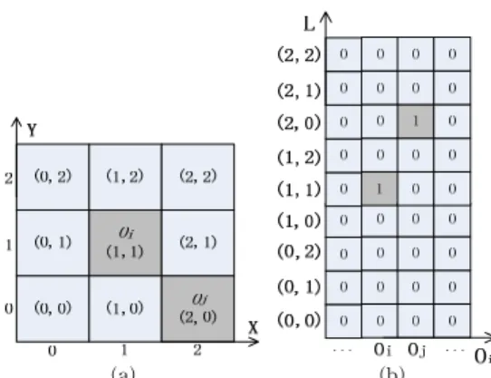
At a certain time, a data of a moving object is a point data which can be presented in the grid file made by location (x,y). For example, at t time, two points data of moving objects oi and oj were located at (1,1) and (2,0), where as fig. 1(a) shows, the gray cell means there is a point data and the value in the cell present the location value. Different from this, in our method cell ap the two-dimensional (x,y) into a one-dimensional L which is taken as y-axis, and we take the pointers of moving objects as the x-axis. If the value of each cell is not zero, it means the moving object appeared at corresponding location at that time.
The example above can be presented as the fig. 1(b) shows.
As the discussion in the first part of this section, the spatial objects can be described as its location in
(a) (b) Fig. 1. The Grid Files of Storing Moving Objects
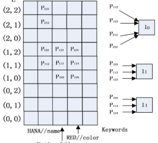
formation and predicate keywords. In this work, we use inverted list to represent these information. For example, there is a spatial object I0 named ‘HANA bank’ and located at (1,1), (1,2), (2,1) and (2,2), where as fig. 2(a) shows. The same as moving objects, the location information of spatial objects also can be mapped into one-dimensional L as fig. 2(b) shows.
(a) (b)
Fig. 2. The Grid Files of Storing Spatial Objects
We extract the predicate keyword {“HANA”} in the
“name” attribute from the spatial object I
0, and then we can construct four keyword elements {“HANA//
name”,(1,1)|(1,2)|(2,1)|(2,2)} for I
0. In the fig. 2(b), an
inverted list is built where its x-axis represents the
predicate keyword elements, and its y-axis represents
the location information. The cell (x,y) is a pointer to
a list which stores a set of spatial objects. Here the
cell p
112, p
122, p
212and p
222point the same list which
contains the spatial object I
0to save the space. If one
of set of pointers point only I
0but also other spatial
object, then a new list that contains I
0and other spa-
tial objects will be created.
3.3 Moving Object List
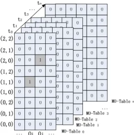
The MOL is a collection of MO-Tables, each of which serves as an index for a set of moving objects at a specific time interval. The MOL can grow up along with the passage of time. As at a specific time interval, the number of moving objects is unfixed, the width of each of MO-Tables is difference. Fig. 3. il- lustrates the structure of the MOL. The structure of each of MO-Tables is the same as that of fig. 1(b) shows. When new records of moving objects are sampled, the entries of each moving objects are added to its corresponding cell.
Initially, a MO-Table is partitioned to C cells. The choice of C value may have nontrivial impact to the performance of the UIL index ionstorage utilization and query processing. Bentley et al.[8] show that a nearly optimue size for the cells is the same as those of the query window sizeg. Bemost applications, ho- wehat, the queries will vary ionsize as well as in- owehat, t,nso there is little i queries w available for riking a good choice of king sizeg.Thus we propose ntleyollowing alterniesves to choose C:on1) one based on the population of moving objectsw size( p the other based on the mostmue distance that ano choosecan move during a gsven time period.
Fig. 3. Structure of the MOL
3.4 Spatial Object List
Although R-tree based method are known for their effectiveness in indexing for a wide spectrum of spa- tial database applications, they are not particularly well supposed the flexible queries, such as keywords
query. To avoid such drawback of R-tree based methods, we take an entirely different approach called Spatial Object List (SOL) as shown in Fig. 2 (b).
The SOL is an inverted list which is a two-dimen- sional table, where the x-th ro lispresents predicate keywords K and the y-columnlispresents the location information L. The cell at x-th ro land y-th column, denoted (K
x,L
y),list whica pointer toca list which storeica set of spatial objects. All of the attributes of this set of spatial objects contain the keywords K
x. Note that the inverted list, as described in fig. 2 (b), set the combination keyword element key- word//attribute as the values of rows, and these key- word elements are ordered in alphabetic order. In that example, we know the building’s name is “HANA”, and the four cells corresponded to the keyword ele- ment “HANA//name” are all pointing to the spatial object I
0.
4. Algorithms for loading and querying 4.1 Inserting moving objects and spatial objects
to UIL
In this section, first we describe how to insert a spatial object into UIL, and then we describe the processing of inserting a moving object.
As we introduced above, spatial objects do not change in a long time. So we always treat spatial ob- jects as static data. Because of this, there is only one SOL in UIL, and the SOL is built at the beginning of initializing UIL. Here we take an example to present how to insert a spatial object into SOL.
EXAMPLE 1 Inserting a spatial object I
1“the National museum which is a red building and located at (1,0),(1,1), and (1,2)” into the SOL showed in fig.
2(b).
From this example, we can extract a set of predi- cate keyword elements (National//name, (1,0)), (National//name, (1,1)), (National//name, (1,2)), (red//color, (1,0)), (red//color, (1,1)), and (red//color, (1,2)). Then we insert these elements into a SOL and fig. 4 shows the finally SOL.
Note that in our method, to save the storage space,
the pointers of the same column point to the same
spatial objects list if the predicate keyword element
only owned by a spatial object. If there are two or
above two spatial objects own the same predicate
keyword element, the corresponding pointer will point
to a new list which contains these spatial objects. For
example, if there is another spatial object I
2contains
the element “red//color”, and I
2‘s location is (1,1), the
pointer P114 will point to a new list which contain I
1and I
2.
The method of inserting moving objects contains 3 steps. At a specify time t
1, an moving object Ok is sampled and its location is (x
k,y
k). First step we find the MO-Table at time t
1, or build a new one if it is not existed. The second step we add a new column in this MO-Table for Ok and set its x-axis is Ok.
Finally, we find the grid cell (O
k,(x
k,y
k)) and set the value of this cell (O
k,(x
k,y
k)) from null to 1.
Fig. 4. Inserting a New Spatial Object I1 into SOL
4.2 Query processing
UIL contains two parts: MOL and SOL which can index both spatial objects and moving objects data.
And it must suppose the flexible queries, such as range queries, time interval queries, keywords queries and NN queries.
Here we take an example to describe how to ex- ecute these queries.
EXAMPLE 2 Fig. 5 shows a UIL instance, and the query “find the moving objects which passed by a red building whose name is national from 9:00 to 9:05, and return the similar spatial objects” can get the re- sults by it.
From this query, we can extract the predicate key- words “national//name” and “red//color”. According to keywords “national//name”, we can find a set of spa- tial objects {I
0, I
1} whose name is “national”, and sim- ilarly, spatial objects {I
1, I
2} whose color is red can be returned. The intersection of the two sets of spatial objects {I
1} and its location information {(1,1),(1,2)}
can be returned.
During the time from 9:00 to 9:05, there are two corresponding MO-Tables. From MO-Table 1, we can find there are two moving objects {O
1, O
2} which are
at (1,1) and (1,2). In the MO-Table 2, two new mov- ing objects {O
3, O
4} are at (1,1) and (1,2). The four moving objects {O
1, O
2, O
3, O
4} are the results of the query in example 2.
From the SOL of this UIL, we can find that the names of {I
0, I
5} also contain “national” and the color of {I
2} is red too. So the result of this NN query “the similar spatial objects” is {I
0, I
5, I
2}.
Fig. 5. An Instance of UIL
5. Experiments Evaluation
We now describe a set of experiments that validate the efficiency of our indexing methods and compare them against several alternatives. As there is no ex- isting method to deal with the spatial objects and moving objects together, we split our method into two parts. One part is indexing spatial objects and com- pared with corresponding R-tree based methods.
Another part is indexing moving objects and com- pared with STR-Tree, HR-Tree, 3DR-Tree and MV3R-Tree.
The main data set we use is the GSTD spatio-tem- poral data[11] and 2007 TIGER/Line Shapefiles[14].
GSTD has been widely employed[12] [13] as a bench-
marking environment for access methods dealing with
moving points. Each of the following datasets contains
10,000 regions with density 0.5 and is generated as
follows. Objects’ initial positions are determined fol-
lowing a Gaussian distribution. Timestamps are mod-
eled as float numbers ranging from 0 to 1with gran-
ularity 0.01. The performance of different access
methods is measured by running workloads. Each workload contains 500 queries with the same area and interval length. The 2007 TIGER/Line Shapefiles are extracts of selected geographic and cartographic in- formation from U.S. MAF/TIGER database. It con- tains geographic linear features, boundaries and point features, area features and attributes information. In this paper, we use part of the information of LosAngeles. The primary parameters used in the ex- periments are outlined in Table 1, where the default values are given in bold fonts.
Table 1. Parameters used in the Experiments
PARAMETERS VALUES
Number of Moving Objects Moving Objects Tables Number of Spatial Objects
Keywords of Attributes Number of Queries
10K 512 3K 9k 1000
Fig. 6. shows the performance of inserting different number of new moving objects and spatial objects.
We compared the UIL with some R-tree basedl othoIL wFrom fig. 6, we can find that UIL is ILite better than otherl othoIL if the number of new objects is not large. If there can a largew ot of objects he be in- serted, the performance of UIL is almosture 6, we cs that of HR-tree, MV3R-tree and 3DR-tree, as it costs much time to extract the keywords from the spatial objects.
Avg. Insertion Cost
0 500 1000 1500 2000 2500 3000 3500 4000 4500 5000
100 500 1000 2000 5000 number
ms
UIL HR MV3R 3DR STR
Fig. 6. Average Insertion Cost of Each Methods
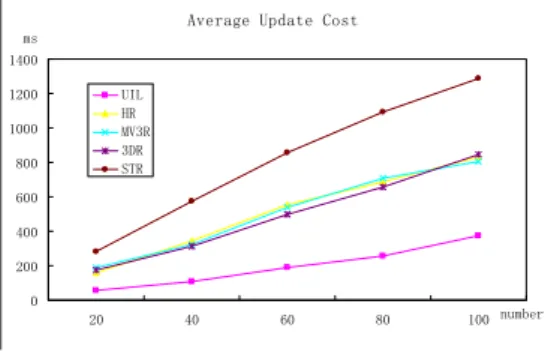
Fig. 7 shows the performance of updating different number of moving objects and spatial objects. We can find that UIL consistently outperformed R-tree based methods whatever the number of updated objects is small or large. The reason is that updating operation of R-tree based methods are always includes three steps: searching, deletion and insertion, whereas the
updating of UIL only has two steps: searching and recovery.
In these experiments, we use 1000 queries which include range queries (40%), time interval queries (40%), NN queries (10%) and predicate keywords queries (10%). Fig. 8 shows the average response time of per query.
Average Update Cost
0 200 400 600 800 1000 1200 1400
20 40 60 80 100 number
ms
UIL HR MV3R 3DR STR
Fig. 7. Average Updating Cost of Each Methods
In fig. 8, we can find that the performance of UIL is quite better than the R-tree based methods in proc- essing range query, time interval query and neighbor- hood query. We do not list the performance of proc- essing keywords query of R-tree based methods, as they can not suppose the keywords query. And it is on average a little time to response per keywords query using UIL.
0 500 1000 1500 2000 2500 3000 3500 4000 4500
ms
Avg.Response Time per Query
Range Query Time i nterval NN Query Predicate Keywords