식생기반재 뿜어붙이기의 비탈면 녹화이후 침식 안정성 평가 방법
길 승 호
강원대학교 생태조경디자인학과
Evaluating Erosion Risk of Revegetated Cutslope with Seed Spraying
Kil, Sung-Ho
Department of Ecological Landscape Architecture Design, Kangwon National University
ABSTRACT
Slope revegetation refers to the use of vegetation and construction to protect a barren slope devastated by road and building construction. Among many revegetation strategies, hydroseeding has been widely utilized to stabilize barren slopes and has become the representative approach. Previous studies on slope stability have been conducted from a civil engineering perspective, mainly evaluating the stability of cut-slopes on solid bedrock and the use of concrete structures to stabilize devastated slopes. This study was conducted to develop a method to evaluate erosion risk of revegetated cut-slopes, based on criteria derived from previous studies. Twenty-five factors were surveyed on both on-the-spot erosion slopes and non-erosion slopes after slope revegetation to compare slope types. The scores of all non-erosion slopes exceed 80 score while erosion slopes are 80 below. Erosion slopes got the range of 68-74 score while non-erosion slopes got the range of 81-100 score in the first result which was not applied for weighted-values. The scores of all non-erosion slopes exceeded 3.10, while erosion slopes were below 3.10. Erosion slopes were in the range of 2.73-3.09, while non-erosion slopes were in the range of 3.15-3.90 in the second result, which was applied with weighted-values according to the AHP result from a previous study.
First author:Kil, Sung Ho, Department of Ecological Landscape Architecture Design, Kangwon National University, Tel:+82-33-250-8342, E-mail:[email protected]
Corresponding author:Kil, Sung Ho, Department of Ecological Landscape Architecture Design, Kangwon National University,
Tel:+82-33-250-8342, E-mail : [email protected] Received:2 November, 2016. Revised:11 December, 2016. Accepted:22 November, 2016.
- 63 -
Key Words:Ecological Restoration, Revegetation Stability, Slope Revegetation, Analytic Hierarchy Process
I. 서 론
도로확장 및 신도시건설, 위락단지 조성 등의 대규모 개발공사는 인공적인 훼손 비탈면을 형 성하여 산사태와 홍수 등으로 인한 붕괴사고가 빈번히 일어나고 있다. 이러한 비탈면은 기존 식 물이 훼손되었기 때문에 녹화에 많은 제약이 있 다. (Balisky and Burton, 1995; Schiechtl, 1980).
우리나라는 훼손 비탈면 복구를 위해 다양한 비 탈면 복원 공법들이 시행되고 있다. 그 중 식생기 반재를 포함한 종자뿜어붙이기 공법이 널리 사 용되고 있다(Lee and Park, 2006).
우리나라는 비용이 저렴한 녹화공법들이 다 수 존재하고, 조기 녹화용 외래도입초본을 과다 하게 파종하는 사례가 많다(Kim et al., 2008).
그 결과 훼손지의 빠른 복구를 위해 외래초본종 을 도입한 공법 적용으로 주변 식생과 조화롭지 못한 경관이 조성되었다. 또한 녹화공사 후 수 년 내에 외래 초본류가 쇠퇴하면서 비탈면이 다 시 황폐화되고 침식 등의 피해를 유발하고 있다 (Kim, 1998).
훼손된 비탈면 관리와 관련된 국내 법률을 검 토해 보면, 행정자치부는 ‘자연재해대책법’, ‘급 경사지1) 재해예방에 관한 법률’, 국토교통부는 2009년 도로개설로 인한 훼손된 비탈면 녹화를 위해 ‘도로비탈면 녹화공사의 설계 및 시공 지 침’이 있으며, 산림청의 임도 설치, 자연 재해로 인한 훼손 복구 등으로 인한 비탈면 관리로서
‘사방사업법’이 있다.
붕괴, 탈락, 침식 등과 관련된 평가 방법은 급 경사지 재해위험도 평가기준(국민안전처), 산사 1) 급경사지 : 지면으로부터 높이가 5미터 이상이고,
경사도가 34도 이상이며, 길이가 20미터 이상인 인 공 비탈면(급경사지 재해 예방에 관한 법률 시행 령)
태 위험 평가(산림청) 등이 있으며, 산사태 발생 위험 평가기준(Choi, 2001), 공간분석을 이용한 산사태 위험 분석 및 예측 기술(Kim et al., 1991; Ma, 1994; Kim et al., 2009), 국내 9개 사 면 안정성 평가법과 국외 4개국 8개 사면 안정 성 평가법을 비교 분석하여 국내외 사용 빈도 분석 후 토사 및 암반 재해 위험도 평가 기준 설 정(Jeong, 2009)이 있으며, 사면 위험도 평가 방 식(Kim et al., 2012; Lawrence and Robert, 1993;
NEMA, 2011)등 다양한 방법으로 관련 연구를 진행하여 왔다. 하지만, 대부분 토목공학적인 접근이었으며, 지질학적, 구조적 안정성에 초점 을 두고 있다.
인공비탈면 녹화의 경우 사방안정해석을 통해 이루어진 비탈면 구조적 안정성이 확보된 상황 에서 식생기반재 뿜어붙이기, 식재 등 다양한 방 법으로 비탈면 안정화 도모를 위해 노력하고 있 다. 하지만, 붕괴, 침식 등은 계속적으로 일어나 고 있다. 한국도로공사에서 2001년부터 2003년 까지 조사한 고속도로 주변의 붕괴 발생 유형을 분석해본 결과, 법면 유실이 가장 많았으며, 구조 물 파괴가 그 뒤를 따랐다(Yun et al., 2009).
식생기반재 뿜어붙이기 공법은 비탈면에 붙 이는 두께에 달라지지만 일반적으로 식생기반 재, 종자, 비료 등을 혼합하여 습식으로 뿜어붙 이기하는 공법을 말한다(국토교통부, 2009). 식 생기반재는 토양개량제, 음식물 쓰레기, 임목폐 기물 등 다양한 재료의 혼합비율에 의해 형성 (Kim et al., 2006; Heo YJ et al., 2009; Cho et al., 2015; Park et al., 2016)되는데 식생 형성과 정과 토양 특성이 상이한 부분들이 많다. 식생 기반재에 대한 침식저항능력 측정을 위한 연구 (Oh et al., 2015; Seong et al, 2015)가 진행되었 지만, 토양에 대한 전단강도 측정이나 강우에
의한 침식을 측정하는 것에 초점을 두고 있다.
현재 국토교통부(2009)에 나타난 비탈면 녹 화 평가는 녹화공법 선정을 위한 평가방법으로 일반적으로 하자보수기간 2년 이전에 실시된다.
하지만 녹화 침식은 계속적으로 일어나고 있으 며 이에 대한 대응방법으로 현재 침식된 장소의 문제점을 파악하고 녹화 개선을 위한 평가방법 이 요구된다.
국내외 연구에서 토목공학적 사면안정해석과 관련된 연구는 많이 진행되었지만, 녹화 안정성 과 관련된 연구는 미흡한 편이다. 즉, 훼손된 비 탈면에 대한 토질 역학, 구조적 안정성을 위한 연구는 진행되었지만, 안정화 방법 중 하나인 녹화의 지속성 및 안정성에 대한 부분은 연구가 미진하다.
본 연구는 사면안정해석과 관련된 부분은 최
Category Assessment factors
Topography Slope angle, Aspect, Slope length, Slope height, Slope type Geography Ground condition, Seepage water
Climate Rain intensity, Accumulated rainfall
Soil Soil physics Porosity, Soil hardness, Water contents, Soil texture, Tensile strength, Hydraulic conductivity
Soil chemistry Soil acidity (pH), Salt concentration, Organic Matter
Vegetation Vegetation community, Vegetation coverage rate, Number of trees, Number of herbs Construction Elapsed year, Drainage condition, Soil depth
Table 2. Assessment factors for evaluating slope stability and revegetation
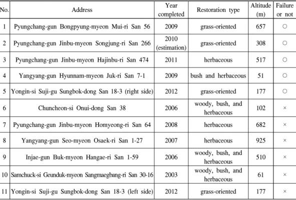
No. Address Year
completed Restoration type Altitude (m)
Failure or not 1 Pyungchang-gun Bongpyung-myeon Mui-ri San 56 2009 grass-oriented 657 ○ 2 Pyungchang-gun Jinbu-myeon Songjung-ri San 266 2010
(estimation) grass-oriented 308 ○ 3 Pyungchang-gun Jinbu-myeon Hajinbu-ri San 474 2011 herbaceous 517 ○ 4 Yangyang-gun Hyunnam-myeon Juk-ri San 7-1 2009 bush and herbaceous 51 ○ 5 Yongin-si Suji-gu Sungbok-dong San 18-3 (right side) 2012 grass-oriented 177 ○ 6 Chuncheon-si Onui-dong San 38 2006 woody, bush, and
herbaceous 102 ×
7 Pyungchang-gun Jinbu-myeon Homyeong-ri San 64 2008 herbaceous 682 ×
8 Yangyang-gun Seo-myeon Osaek-ri San 1-27 2007 herbaceous 925 ×
9 Injae-gun Buk-myeon Hangae-ri San 1-59 2006 woody, bush, and
herbaceous 510 ×
10 Samchuck-si Geunduk-myeon Sangmaegbang-ri San 30-16 2003 woody, bush, and
herbaceous 61 ×
11 Yongin-si Suji-gu Sungbok-dong San 18-3 (left side) 2012 grass-oriented 177 × Table 1. Site information
소화 하였다. 그 이유는 비탈면을 형성할 때 구 조적인 부분은 선행적으로 이루어지며 비탈면 녹화는 구조적 안전성에 도움을 주는 역할로 식 생 안정과 주변환경과 어우러지는 경관 형성에 더 초점을 두고 있기 때문이다.
본 연구는 지속적으로 발생하고 있는 비탈면 침식을 방지하기 위한 수단으로 비탈면 침식 안 정성에 대한 평가방법을 제안하고자 한다. 본 연구의 주요과정은 첫째, 비탈면 녹화의 안정성 평가항목을 위한 조사방법을 개발하는데 있다.
둘째, 평가항목을 활용하여 실제 침식된 지역과 침식되지 않은 지역에서의 평가를 한다. 셋째, 적용된 평가결과와 평가항목과의 비교분석을 통해 주요 사례에 대해 고찰한다.
II. 연구 방법
1. 연구 방법
본 연구는 비탈면 녹화가 된 이후 훼손된 비 탈면의 일반현황, 토양의 이화학적 특성 및 식 Categories Local
weight Variables Local weight Global weight Rank
Topography 0.154
Slope angle 0.465 0.0716 3
Aspect 0.104 0.0160 25
Slope length 0.111 0.0171 24
Slope height 0.158 0.0243 18
Slope type 0.162 0.0249 17
Geography 0.147 Slope soil and rock condition 0.409 0.0601 5
Seepage water 0.591 0.0869 2
Climate 0.152 Rain intensity 0.668 0.1015 1
Accumulated rainfall 0.332 0.0505 8
Soil
Soil
physics 0.163
Porosity 0.127 0.0207 22
Soil hardness 0.111 0.0181 23
Water content 0.137 0.0223 21
Soil texture 0.202 0.0329 12
Tensile strength 0.232 0.0378 9
Permeability coefficient 0.191 0.0311 14
Soil
chemistry 0.088
Soil acidity 0.264 0.0232 19
Salt concentration 0.361 0.0318 13
Organic matter 0.375 0.0330 11
Vegetation 0.170
Vegetation community 0.305 0.0519 7
Vegetation coverage rate 0.333 0.0566 6
Number of trees 0.164 0.0279 16
Number of herbs 0.198 0.0337 10
Construction 0.125
Elapsed year 0.250 0.0313 15
Drainage condition 0.564 0.0705 4
Soil depth 0.185 0.0231 20
Table 3. Weighted values and ranks for AHP results (Revised by Kil et al., 2016)
생 특성에 따라 붕괴 위험도 평가를 통해 지속 가능한 복원 방법을 모색하고자 하는 연구라 할 수 있다.
연구의 방법은 크게 3가지로 구분할 수 있는 데 1) 침식위험 평가체계 설정방법, 2) 현장조사 방법, 3) 붕괴 위험 평가로 나누어볼 수 있다.
1) 침식위험 평가체계 설정방법
Kil et al.(2016)은 침식 위험의 평가항목 도출 을 위하여 관련 문헌 조사, 국내외의 법령, 기준, 원칙의 종합적인 검토를 통하여 평가항목를 설 정하고 AHP 조사 및 분석을 통해 도출된 항목 간 상대적 중요도를 산출하였다. 이 자료를 통 해 각 평가항목에 대한 조사 방법 및 기준을 설 정하였다. 조사 항목은 다음의 Table 2와 같으
며, Kil et al.(2016)에 나타난 AHP 분석 결과의 Table 3은 다음과 같다.
2) 현장조사 방법
현장 조사 방법은 침식된 지역(5곳)과 침식이 전혀 이루어지지 않은 지역(6곳)을 선정하여 총 11곳을 조사하였다. 침식된 지역은 지속적인 침 식이 이루어질 수 있는 잠재위험군으로 판단하 였고, 침식이 전혀 이루어지지 않은 지역은 비 탈면 녹화 시기를 알 수 있으며, 현재까지 재해 가 일어나지 않은 곳을 선정하였다. 각 대상지 의 녹화 시기는 담당 공무원 및 해당 주민들의 인터뷰를 통해 확인하였다.
조사항목 중 침식이 일어난 곳의 강우강도와 누적강우량에 대한 올바른 측정방법은 침식이
Score Explanation Remarks
Very good (5)
Soil ∙Being able to marks by blasting or heavy equipments.
∙high clay content
Revising content and organization by
notification of NEMA(2009)a
nd Jeong IH(2009) Weathered rock ∙[eluvium]the condition turned into soil from rock and relict
fabric not observed Hard rock ∙little joint plane
Good (4)
Soil ∙Being able to marks by hand shovel with somewhat difficulty
∙High silt content
Weathered rock ∙[Completely weathering] The condition turned into soil from rock and relict fabric observed
Hard rock ∙Reverse joint plane
Normal (3)
Soil ∙Being able to marks by hand shovel
∙Mixed gravel or rock
Weathered rock ∙[extremely weathering] Mostly discolored or color-tinted minerals Hard rock ∙Horizontal joint plane(a<15°)
Bad (2)
Soil ∙Being able to marks by hand shovel easily
∙Mixed sandy soil
Weathered rock ∙[Normal weathering] Partially discolored and weathered rocks Hard rock ∙Vertical joint plane
Very Bad (1)
Soil ∙Being able to marks by a thumb or a fist easily
∙sandy soil
Weathered rock ∙[slightly weathering] Overall fresh rock but dicolored or color- tinted condition toward joint plane
Hard rock ∙Joint plane the same as slope gradient(a>15°) Table 4. Criterion for slope soil and rock condition
Category 1 Category 2
Unit Very bad Bad Normal Good Very good Global
weight Ref.
Score 1 2 3 4 5
Topography
Slope angle ° over 60° 45°-60° 35°-45° 30°-35° below 30° 0.0716 1)
Aspect - S-SW SW-W S-SE
W-NW
NW-N N-NE
NE-E
E-SE 0.0160 2), 3), 4)
Slope length m over 100 50-100 30-50 10-30 below 10m 0.0171 5),
6), 7)
Slope height m over 40 30-40 20-30 10-20 below 10m 0.0243
Slope type -
overhanging, breakaway
slope
Compound (凹凸)
Convex (凸)
Concave (凹)
Straight
(□) 0.0249 7), 8), 9)
Geography
Slope soil and
rock condition - See table 4 0.0601 11),
12)
Seepage water - Outflow Dripping Wetting Moistness Completely
dry 0.0869 12)
Climate
Rain intensity
(hourly rainfall) ㎜/h over 50 30-40 20-30 10-20 below 10 0.1015 13),
14) Accumulated
rainfall (two days)
㎜ over 250 200-250 150-200 100-150 below 100 0.0505
13), 14), 15)
Soil physical properties
Porosity ㎥/㎥ below 0.3 0.3-0.4 0.4-0.5 0.5-0.6 over 0.6 0.0207
5), 16), 17), 18), 19)
Soil hardness ㎜ over 27 24-27 21-24 18-21 below 18 0.0181
Water content ㎥/㎥ below 0.02 0.02-0.04 0.08-0.04 0.12-0.08 over 0.12 0.0223
Soil texture - Silt,
Sand, Silt loam
Silty clay loam, Loam
Clay, Silty clay, Sandy loam, Sandy clay loam,
Clay loam
Loamy sand, Sandy clay
0.0329
Tensile strength ㎎/㎥ below 1.1 1.1-1.4 1.4-1.7 1.7-2.0 over 2.0 0.0378 Hydraulic
conductivity ㎝/s ≤1.0×10⁻³ 1.0×10⁻³ ~ 2.5×10⁻³
2.5×10⁻³ ~ 4.5×10⁻³
4.5×10⁻³ ~
6.0×10⁻³ ≥6.0×10⁻³ 0.0311
Soil chemical properties
Soil acidity(pH) ㎜ below 3.5 over 9.5
3.5-4.5 8.0-9.5
4.5-5.5 7.0-8.0
5.5-6.0
6.5-7.0 6.0-6.5 0.0232 Soil
concentration % over 0.5 0.3-0.5 0.2-0.3 0.05 - 0.2 below 0.05 0.0318 Organic matter % below 1.0 1.0-2.0 2.0-3.0 3.0-5.0 over 5.0 0.0330
Vegetation
Vegetation
landscape - Poor
vegetation
Heterogeneou s simple layer
Homogeneous simple layer
Heterogeneous multiple layer
Homogeneo us multiple
layer
0.0519
5), 7), 20) Vegetation
coverage rate % 0-20 20-40 40-60 60-80 over 80 0.0566
Species diversity
No.
of herbs
No. 0-5 6-10 11-15 16-20 over 20 0.0279
No.
of trees
No. 0-1 2-3 4-5 6-7 over 8 0.0337
Construction
Elapsed year year 0-1 1-3 3-6 6-9 over 9 0.0313 5), 7)
Drainage
condition - Very bad Bad Normal Good Very good 0.0705 11)
Soil depth cm 0-2 3-5 5-10 10-15 over 15 0.0231 21)
Source: 1) KILA(2007); 2) Cano et al.(2002); 3) Lee S.(2012); 4) Nam SJ and Kim NC.(1998); 5) Kil et al.(2011); 6) Jeon GS.(2004), 7) Lee SC et al.(2012), 8) Jeon KS and Ma HS.(2004); 9) Jeon KS et al.(2003); 10) Park MS.(2002); 11) Jeong IH.(2009); 12) NEMA(2011); 13) Kim KS(2008); 14) Kim WY and Chae BG.(2009); 15) Kim SW et al.(2012); 16) Park GS et al.(2006); 17) Oh KK.(2007); 18) MOLIT(2011); 19) Jeon GS.(2002); 20) Kim NC et al.(2007); 21) MOLIT(2009)
Table 5. Comprehensive criterion for assessment factors
일어난 시점의 강우강도와 누적강우량을 측정 해야 한다. 하지만, 침식이 일어난 시점을 찾는 것은 현실적으로 어렵기 때문에 침식이 일어난 연도에서 발생지점과 가장 가까운 곳의 자동기 상장치(AWS)로 측정된 것으로 6월부터 9월 사 이에 발생한 누적강우량(2일)이 가장 높은 기간 에서 시간당 강우량이 가장 높은 극값을 찾아 강우강도로 적용하였다. 침식이 일어나지 않은 지역은 비탈면 녹화이후 누적강우량(2일)이 가 장 높은 기간에서 시간당 강우량이 가장 높은 극값을 찾아서 적용하였다. 이는 비탈면 녹화 이후 극값을 보이는 강우패턴에도 침식이 일어 나지 않았음을 확인하기 위함이었다.
토양조사는 침식된 지역(5곳)과 침식되지 않 은 지역(6곳)에서 100cc캔을 이용하여 각 장소 마다 3개씩 추출하였다. 총 11곳의 현장에서 총 33개의 토양샘플을 취득하여 각 항목에 따라 분 석하였다.
식생은 MOLIT(2009)의 기준을 적용하여 정 량적(식생피복률, 한지형 초종을 제외한 식생피 복률, 목본 성립본수, 출현종수, 식생생육량, 수 고 및 초장), 정성적(식생경관, 영급, 경급, 발아 상태, 생육정도)에 대한 내용을 장소마다 3번 반 복하여 현장에서 기입하여 조사하였다.
3) 침식 위험 평가 방법
각 항목에 대한 평가방법은 기존 문헌에서 나 타난 결과를 바탕으로 구성하였으며 이에 대한 결과표는 Table 5와 같다. 평가항목 중 기반층 의 내용은토사, 풍화암, 암반에 따라 적용되어 야 할 것이 많아 분리된 Table 4로 정리하였다.
침식 위험 평가는 1차적으로 문헌 고찰을 통 해 평가기준이 설립하였으며 각 대상지 조사결 과를 바탕으로 평가를 실시하였다. 1차 평가결 과는 항목이 25개이기 때문에 최대값은 125점 이며, 최소값은 25점이다.
2차 평가방법은 1차 평가에서 나타난 결과 와 Kil et al.(2016)에 나타난 AHP 분석결과의
가중치를 곱하여 계산하였다. 1차 평가결과와 중요도가 적용된 2차 평가결과와 비교 분석하 였다. 중요도를 적용한 이후 최대값은 5점이며, 최소값은 1점이다.
III. 결과 및 고찰
1. 침식위험 평가체계
평가체계는 선행 연구자료를 활용하여 작성 하였다. 지형은 경사, 향, 비탈면 높이, 비탈면 길이, 비탈면 형태이며, 지질은 기반층 상태, 지 하수 용출상태이며, 기후는 강우강도와 누적강 우량, 토양은 공극률, 토양경도, 수분함량, 토성, 인장강도, 투수계수, 토양산도(pH), 염분, 유기 물함량이고, 식생은 식생군락, 식생피복률, 종다 양성이며, 일반현황은 경과년도, 배수상태, 녹화 한 토심으로 구성되었다.
2. 침식위험 평가결과
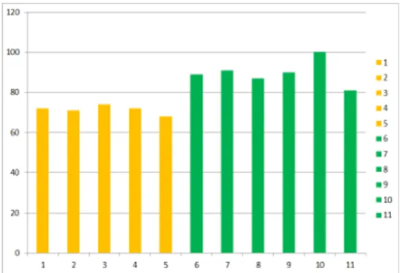
1번부터 5번은 침식이 일어난 장소이며, 6번 부터 11번까지는 침식이 일어나지 않은 장소이 다. 1차 평가결과 1번부터 5번까지의 점수는 68~74점의 분포를 보였으며 평균 71.4점이었고, 6번부터 11번까지의 점수는 81~100점으로 평균 점수는 89.67으로 나타났다. 침식이 일어난 곳 모두 80점 이하였으며 침식이 일어나지 않은 6 곳은 80점이상이었다(Figure 1, Table 6).
Figure 1. Evaluation result on pre-weighted values
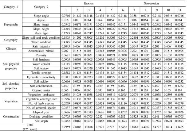
Category 1 Category 2 Erosion Non-erosion
1 2 3 4 5 6 7 8 9 10 11
Topography
Slope angle 0.0716 0.1432 0.2148 0.1432 0.1432 0.2148 0.358 0.0716 0.2148 0.0716 0.0716 Aspect 0.016 0.08 0.064 0.064 0.064 0.016 0.016 0.064 0.048 0.08 0.064 Slope length 0.0342 0.0171 0.0171 0.0171 0.0342 0.0171 0.0342 0.0171 0.0342 0.0342 0.0342 Slope height 0.1215 0.0243 0.0243 0.0972 0.0729 0.0972 0.1215 0.0243 0.1215 0.0243 0.0729 Slope type 0.1245 0.0747 0.0747 0.1245 0.1245 0.1245 0.0996 0.0747 0.1245 0.1245 0.1245 Geography Slope soil and rock condition 0.1803 0.1202 0.3005 0.1202 0.3005 0.2404 0.2404 0.3005 0.3005 0.3005 0.3005 Water condition 0.4345 0.4345 0.4345 0.4345 0.4345 0.4345 0.4345 0.4345 0.4345 0.4345 0.4345 Climate Rain intensity 0.3045 0.406 0.3045 0.3045 0.3045 0.203 0.3045 0.203 0.203 0.406 0.3045 Accumulated rainfall 0.202 0.1515 0.202 0.1515 0.0505 0.0505 0.202 0.101 0.101 0.1515 0.0505
Soil physical properties
Porosity 0.0621 0.0828 0.0621 0.0828 0.0621 0.0828 0.0828 0.1035 0.1035 0.1035 0.0828 Soil hardness 0.0905 0.0905 0.0905 0.0905 0.0543 0.0905 0.0905 0.0905 0.0905 0.0905 0.0905 Water content 0.1115 0.0892 0.0892 0.0892 0.0669 0.1115 0.0669 0.1115 0.1115 0.1115 0.1115 Soil texture 0.1645 0.0329 0.0329 0.0329 0.1645 0.1645 0.1645 0.1645 0.1645 0.1645 0.1316 Tensile strength 0.1512 0.1134 0.1134 0.1134 0.1134 0.1134 0.1134 0.1512 0.189 0.1512 0.1512 Hydraulic conductivity 0.0311 0.0933 0.0933 0.0311 0.0622 0.0622 0.0622 0.1555 0.0311 0.0933 0.1555 Soil chemical
properties
Soil acidity 0.0696 0.0928 0.0928 0.0696 0.0696 0.0696 0.0696 0.0696 0.0696 0.0696 0.0232 Salt concentration 0.159 0.159 0.159 0.159 0.159 0.159 0.159 0.1272 0.159 0.159 0.1272 Organic mater 0.066 0.066 0.066 0.033 0.033 0.165 0.132 0.165 0.165 0.165 0.165
Vegetation
Vegetation landscape 0.1038 0.1038 0.1038 0.1038 0.0519 0.2595 0.2076 0.1038 0.1038 0.2595 0.1038 Vegetation coverage rate 0.0566 0.1132 0.283 0.1698 0.1132 0.283 0.283 0.283 0.283 0.283 0.283
No. of herb species 0.0279 0.0837 0.0837 0.0558 0.0558 0.1116 0.0837 0.0837 0.0279 0.1395 0.0279 No. of arboreal species 0.0337 0.0674 0.0337 0.0337 0.0674 0.1011 0.1011 0.0337 0.0337 0.1348 0.0337
Construction
Elapsed year 0.0626 0.0626 0.0313 0.0626 0.0313 0.1252 0.0939 0.0939 0.1252 0.1565 0.0626 Drainage condition 0.0705 0.0705 0.0705 0.282 0.0705 0.282 0.3525 0.282 0.141 0.0705 0.0705 Soil depth 0.0462 0.0462 0.0462 0.0462 0.0231 0.0693 0.0231 0.0924 0.0924 0.0924 0.0693 Total
(125 score) 2.7959 2.8188 3.0878 2.9121 2.727 3.6482 3.8965 3.4017 3.4727 3.8714 3.1465
Table 7. Evaluation result on post-weighted values
Category 1 Category 2 Erosion Non-erosion
1 2 3 4 5 6 7 8 9 10 11
Topography
Slope angle 1 2 3 2 2 3 5 1 3 1 1
Aspect 1 5 4 4 4 1 1 4 3 5 4
Slope length 2 1 1 1 2 1 2 1 2 2 2
Slope height 5 1 1 4 3 4 5 1 5 1 3
Slope type 5 3 3 5 5 5 4 3 5 5 5
Geography Slope soil and rock condition 3 2 5 2 5 4 4 5 5 5 5
Water condition 5 5 5 5 5 5 5 5 5 5 5
Climate Rain intensity 3 4 3 3 3 2 3 2 2 4 3
Accumulated rainfall 4 3 4 3 1 1 4 2 2 3 1
Soil physical properties
Porosity 3 4 3 4 3 4 4 5 5 5 4
Soil hardness 5 5 5 5 3 5 5 5 5 5 5
Water content 5 4 4 4 3 5 3 5 5 5 5
Soil texture 5 1 1 1 5 5 5 5 5 5 4
Tensile strength 4 3 3 3 3 3 3 4 5 4 4
Hydraulic conductivity 1 3 3 1 2 2 2 5 1 3 5
Soil chemical properties
Soil acidity 3 4 4 3 3 3 3 3 3 3 1
Salt concentration 5 5 5 5 5 5 5 4 5 5 4
Organic mater 2 2 2 1 1 5 4 5 5 5 5
Vegetation
Vegetation landscape 2 2 2 2 1 5 4 2 2 5 2
Vegetation coverage rate 1 2 5 3 2 5 5 5 5 5 5
No. of herb species 1 3 3 2 2 4 3 3 1 5 1
No. of arboreal species 1 2 1 1 2 3 3 1 1 4 1
Construction
Elapsed year 2 2 1 2 1 4 3 3 4 5 2
Drainage condition 1 1 1 4 1 4 5 4 2 1 1
Soil depth 2 2 2 2 1 3 1 4 4 4 3
Total
(125 score) 72 71 74 72 68 91 91 87 90 100 81
Table 6. Evaluation result on pre-weighted values
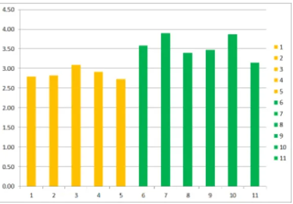
2차 평가결과 1번부터 5번까지의 점수는 2.73~3.09점의 분포를 보였고, 6번부터 11번까지 의 점수는 3.15~3.90점으로 나타났다. 침식이 일 어난 곳 모두 3.10점 이하였으며 침식이 일어나지 않은 6곳은 3.10점 이상이었다(Figure 2, Table 7).
지형과 관련된 경사, 방위, 비탈면 길이, 비탈 면 높이, 비탈면 형태의 평가 값을 모두 더해보 면, 침식이 일어난 지역은 12~16점이며, 침식이 일어나지 않은 지역은 10~18점으로 나타났다.
지질과 관련된 기반층과 용수 유출의 평가 값 을 더한 것은 침식이 일어난 지역이 7~10점, 침 식이 일어나지 않은 지역은 9~10점으로 침식이 일어나지 않은 지역이 좀 더 높았다.
기후와 관련된 강우강도와 누적강우량의 평 가 값을 더해보면, 침식이 일어난 지역이 4~6점, 침식이 일어나지 않은 지역은 3~7점으로 침식 이 일어나지 않은 지역의 점수 분포가 좀 더 넓 었다.
토양물리성과 관련된 공극률, 토양경도, 수분 함량, 토성, 인장강도, 투수계수의 평가 값을 더 해보면, 침식이 일어난 지역이 18~23점, 침식이 일어나지 않은 지역은 22~29점으로 침식이 일어 나지 않은 지역의 점수가 높은 분포를 보였다.
토양화학성과 관련된 토양산도, 염분농도, 유 기물 함량의 평가 값을 더해보면, 침식이 일어 난 지역이 9~11점, 침식이 일어나지 않은 지역 은 10~13점으로 침식이 일어나지 않은 지역의
Figure 2. Evaluation result on post-weighted values
점수가 높은 분포를 보였다.
식생과 관련된 식생경관, 식생피복률, 초본종 수, 목본종수의 평가 값을 더해보면, 침식이 일 어난 지역이 5~11점, 침식이 일어나지 않은 지 역은 9~19점으로 침식이 일어나지 않은 지역의 점수가 높은 분포를 보였다.
건설환경과 관련된 경과년도, 배수상태, 토심 의 평가 값을 더해보면, 침식이 일어난 지역이 3~8점, 침식이 일어나지 않은 지역은 6~11점으 로 침식이 일어나지 않은 지역의 점수가 높은 분포를 보였다.
토양, 식생, 건설환경과 관련된 평가항목에서 침식이 일어난 지역과 일어나지 않은 지역의 점 수가 다소 차이를 보이는 것으로 나타났다.
침식 위험성 평가 이후 침식이 일어난 장소와 그렇지 않은 장소에 대한 평가 항목 중 차이를 보인 내용을 살펴보면 다음과 같다.
1차 평가결과에서 침식이 발생한 지역 중 가 장 높은 점수를 보인 3번(74점)은 다른 곳들에 비해 식생피복률이 92.67%로 침식을 보인 다른 3곳에 비해 매우 높은 수치를 보였으며, 기반층 이 풍화암 지역이었지만 녹화안정성을 위해 코 이어네트를 붙여놓아 높은 점수(5점)을 획득하 게 되었다. 일반적으로 기반층이 토양으로 되어 있을 때, 모래비율이 높고 급경사일 경우에는 코이어네트 또는 철망을 활용하여 침식 방지를 위한 일차적인 보조장치를 활용할 필요가 있다 (Kil, 2014). 2번과 4번 지역은 이러한 상태임에 도 불구하고 보조장치를 활용하지 않아 2점의 낮은 점수를 획득하였다. 또한 2, 3, 4지역은 비 탈면 녹화에 사용된 토성이 Sand로 나타나 1점 의 낮은 점수를 획득하였으며, 침식이 일어나지 않은 지역의 토성에 대한 평가 점수가 대부분 4~5점(6~10: 5점, 11: 4점)으로 침식이 일어난 지역의 점수와 큰 차이를 보였다.
침식이 일어난 장소의 식생 경관은 양잔디가 대부분인 주변환경과 이질적인 단층구조형태 (1~4번)이었으며, 5번은 식생 활착이 제대로 이
루어지지 못한 상황이었다.
또한, 침식이 일어난 지역의 유기물 함량은 2%를 넘지 않아 3%이상을 권장하는 KILA (2007)의 기준에 충족하지 못하고 있음을 확인할 수 있었다. 침식이 일어나지 않은 지역은 대부분 3% 이상을 충족하였으며, 7번 지역은 2.99%로 3%에 거의 근접해 있지만 4점으로 평가되었다.
11번 지역은 침식이 일어나지 않았지만, 토양 산도가 11.17pH로 강한 알칼리성으로 나타났다.
이 지역은 초본종수가 3종(1점), 목본종수는 0 종(1점)이었고, 경사가 급하고 비탈면 면적이 넓 었음에도 배수시설이 제대로 구비되어 있지 않 아 배수상태 점수가 1점밖에 얻지 못하는 등 다 른 침식이 일어나지 않은 지역에 비해 높은 점 수를 받지 못한 것으로 해석되었다.
중요도를 포함한 2차 평가에서 특이한 점은 3번 지역의 점수(3.09)가 11번 지역의 점수(3.15) 와 큰 차이를 보이지 않았다. 침식이 일어난 지역 중 3번 지역은 식생과 관련된 평가점수에서 0.5042로 그 외 침식이 일어난 지역의 식생 관련 된 평가 점수 분포가 0.2220~0.3681로 볼 때, 상 대적으로 높은 점수로 평가된 것으로 보인다. 그 리고, 11번 지역은 식생과 관련된 평가점수 (0.4484)와 건설환경(0.2024)이 그 외 침식이 일 어나지 않은 지역의 식생분포(0.4484~0.8168)와 건설환경(0.3194~0.4695)보다 낮은 점수를 보였 기 때문으로 보인다. 즉, 주변환경과 잘 어울리며 다층구조 형태의 식생 군락과, 높은 식생피복률, 높은 초본 및 목본 종수 확보, 오랜 기간 지속된 경과년수 확보, 기준에 맞는 배수로 확보, 두터운 식생기반재 토심 두께의 확보가 높은 점수를 보 일 수 있음을 알 수 있다.
본 연구결과를 통해 침식 방지를 위한 식생기 반재 뿜어붙이기의 평가 점수를 높이기 위해서 는 물리적 외부환경 즉, 비탈면 녹화를 하기 전 의 상태와 인위적인 개입이 없는 자연적인 조건 을 제외하고 비탈면 녹화에 사용되는 토양 및 건설환경 개선을 위한 검토가 필요하다.
토양 관련 평가점수가 높은 경우 식생 관련 평가점수도 높았다. 즉, 식생기반재에 사용되는 토양이 침식 안정성에 중요한 역할을 한다고 볼 수 있다. 건강한 생물서식기반 환경의 모태가 되 는 토양은 부식층 표토를 충분히 포함해야 한다 (Kim and Jo, 2004). 토양에 표토를 보완해주는 것은 양료공급원을 확보해주며, 물리적 자극에 대해 토양을 보전하는 방법이다(Bradshaw and Chadwick, 1980). 하지만, 비탈 훼손지의 토양은 경사가 매우 급하고, 토심이 매우 얕은 특성으로 인해 양분 및 수분 공급이 어렵고, 겨울에 쉽게 얼게 되며, 식물 뿌리의 정착을 매우 어렵게 하는 등 식물 생육에 매우 불리한 조건을 가지고 있다 (Park et al., 2006; Pritchett and Fischer, 1985).
비탈면 복원에 사용된 토양 특성은 식물의 생육 에 큰 영향을 미친다(García-Palacios et al., 2010;
Kim et al., 1999). 따라서 식물이 자라기 위한 주요 기반인 토양 특성에 대해 정확하게 인지하 여야 하며 본 연구결과에서 나타난 평가기준의 토양 평가에 대한 다양한 검토가 요구된다. 더불 어 MOLIT(2009)에서 제시하고 있는 평가방법 중 일부분은 식생기반재에 사용되는 토양 조건 에 대한 좀 더 세밀한 검토가 필요하다.
IV. 결 론
본 연구는 비탈면 녹화이후 침식된 지역의 토 양 및 식생구조를 종합적으로 평가하기 위해 침 식된 비탈면 녹화 장소와 침식이 일어나지 않은 장소와의 비교를 통해 침식이 발생할 가능성을 평가하기 위한 방법을 개발하였다.
총 25개의 평가항목 및 선행연구에 나타난 중 요도를 통해 침식된 장소 5곳과 침식이 일어나 지 않은 6곳을 대상으로 평가를 실시하였다. 1 차 평가결과 1번부터 5번까지의 점수는 68~74 점의 분포를 보였으며 평균 71.4점이었고, 6번 부터 11번까지의 점수는 81~100점으로 평균점 수는 89.67으로 나타났다. 2차 평가결과 1번부
터 5번까지의 점수는 2.73~3.09점의 분포를 보 였고, 6번부터 11번까지의 점수는 3.15~3.90점 으로 나타났다. 1차 및 2차 평가결과를 통해 가 능한 해석은 80점 이하(1차) 및 3.10 이하(2차) 로 나타난 곳에서 침식이 일어났기 때문에 해당 점수 이하인 곳은 잠재적 침식위험장소로 판단 하고 침식 방지를 위한 관리 방책을 모색할 필 요가 있다.
본 연구는 평가와 관련된 부분을 일반화시키 기 노력하였으나 좀 더 많은 사례수 확보를 통 해 점검해 볼 필요가 있다. 또한, 현재 이루어지 고 있는 안정성 평가는 토목공학적 접근이 대부 분이며 복원성 평가는 일시적 공법 선정에 필요 한 평가이기 때문에 상호보완적인 평가기준을 고찰하여 좀 더 세밀화할 필요성이 있다.
Acknowledgement
본 연구는 Kil SH(2014)의 박사논문의 일부 자료를 활용한 부분이 있으며, 강원대학교 산학 협력단에서 제공하는 기초연구비에 의해 수행 되었으며 이에 감사드립니다.
Reference
Balisky AC and Burton PJ. 1995. Root-zone soil temperature variation associated with microsite characteristics in high-elevation forest open- ings in the interior of British Columbia. Agricu- ltural and Forest Meteorology 77(1-2): 31-54.
Bradshaw AD and Chadwick MJ. 1980. The re- storation of land: the ecology and recla- mat- ion of derelict and degraded land. Univer- sity of California Press.
Cano A ․ Navia R ․ Amezara I and Montalvo J.
2002. Local topoclimate effect on short-term cutslope reclamation success. Ecological Eng- ineering 18: 489-498.
Cho DG ․ Jeon GS ․ Shim YJ ․ Kim DH ․ Do JN and Park MY. 2015. A Study on the mixing ratio of food waste on slope re-vegetation base materials. Journal of the Korea Society for Environmental Restoration and Revegeta- tion Technology 18(6), 215-226 (In Korean).
Choi K. 2001. Landslide prediction and technique to judge a dangerous area. Journal of national institute for disaster prevention. 3(4): 12-27 (In Korean).
García-Palacios P ․ Soliveres S ․ Maestre, FT ․ Escudero A ․ Castillo-Monroy AP and Valla- dares F. 2010. Dominant plant species modu- late responses to hydroseeding, irriga- tion and fertilization during the restoration of sem- iarid motorway slopes. Ecological Engineer- ing. 36(10): 1290-1298.
Heo YJ ․ Koh JH ․ Joo P and Ahn TY. 2009.
The composting technique for on-site recycl- ing of wood waste. Journal of the Korean Society of Environmental Restoration Tec- hnology 12(4): 72-80 (In Korean).
Jeon GS. 2002. A study of improvement method and analysis of type of revegetation measures of rock slopes. Journal of the Korea Society for Environmental Restoration and Revegeta- tion Technology 5(5): 22-29 (In Korean).
Jeon GS. 2004. A study on the revegetation struc- tural analysis for environment factor of road slope. Journal of the Korea Society for Envi- ronmental Restoration and Revegetation Technology 7(2): 12-20 (In Korean).
Jeon KS ․ Oh SY and Ma HS. 2003. Stability evalua- tion of cut slope in forest roads by forest environment factors. Journal of the Korea Society for Environmental Restoration and Revegetation Technology 6(4): 43-51 (In Korean).
Jeon KS and Ma HS. 2004. Changing of vegetation coverage through elapsed years on cutting sl- ope in forest roads. Journal of the Korea Society for Environmental Restoration and Revegetation Technology 7(3): 14-25 (In Korean).
Jeong IH. 2009. The disaster risk evaluation of the steep slope and the field application. Ph.D.
dissertation. Kyungpook National University (In Korean).
Kil SH ․ Lee DK ․ Cho MW and Yang BE. 2011.
A study on the factors affecting vegetation cover after slope revegetation. Journal of the Korea Society for Environmental Restoration and Revegetation Technology. 14(5): 127-136 (In Korean).
Kil SH ․ Lee DK ․ Kim JH ․ Li MH and Newman G. 2016. Utilizing the analytic hierarchy proc- ess to establish weighted values for evaluating the stability of slope revegetation based on hydroseeding applications in South Korea.
Sustainability, 8(1): 58.
Kil SH. (2014) Development of stability evaluation indicators on revegetated cut-slopes of moun- tainous terrain of Korea. Ph.D. disserta- tion.
Seoul National University (In Korean).
The Korean Institute of Landscape Architecture (KILA). 2007. Landscape Design Criterion (In Korean).
Kim GG. and Jo DG. 2004. Natural Environment and Ecological Restoration. Academy Pu- blishing Co (In Korean).
Kim JH ․ Baek YK ․ Ho B and Park KD. 2012.
Use of the risk score for the effective manage- ment of cut slopes. The Journal of Engineering Geology 22(2): 223-231.
Kim JW ․ Jung TG ․ Kim NC and Kwon BS. 2006.
A study on the seeding mixture and applica-
tion test for the restoration and revegetation of the slopes by the thin-layer-soil-media hy- droseeding measures :application by the S.O-Soil spray measures. Journal of the Korea Society for Environmental Restoration and Revegetation Technology 9(6), 143-151 (In Korean).
Kim KH and Woo, BM. 1999. The optimal collec- tion time an methods of utilization of forest topsoil as revegetation materials of slopes.
Journal of the Korea Society for Environmental Restoration and Revegetation Technology 2(2): 53-61 (In Korean).
Kim KS ․ Song YS ․ Chae BG ․ Cho YC and Jeong GC. 2008. Development of investiga- tion and analysis technique to landslides and its application. The Journal of Engineering Geology: 16(2), 69-81 (In Korean).
Kim KS ․ Song YS ․ Cho YC ․ Kim WY and Jeong GC. 2006. Characteristics of rainfall and landslides according to the geological condition. The Journal of Engineering Geo- logy. 16(2): 201-214 (In Korean).
Kim NC ․ Lee JH ․ Lee TO and Heo YJ. 2008.
A study on the use of fresh root-chips in slope revegetation works. Journal of the Korea Society for Environmental Restoration and Revegetation Technology 11(4): 119-128 (In Korean).
Kim NC ․ Song HK ․ Park GS ․ Jeon GS ․ Lee SH and Lee, BJ. 2007. An analytical study on the revegetation methods for highway slopes. Journal of the Korea Society for Environmental Restoration and Revegetation Technology 10(2): 1-15 (In Korean).
Kim NC ․ Suk WJ and Nam SJ. 1998. The study on the seed mixture for the revegetation of cut-slopes. Journal of Korean institute of land-
scape architecture. 26(3): 8-18 (In Korean).
Kim SW ․ Chun KW ․ Kim JH ․ Kim MS and Kim MS. 2012. Characteristics of heavy rain- fall for landslide-triggering in 2011. Journal of Korean Forest Society. 101(1): 28-35 (In Korean).
Kim WY and Chae BG. 2009. Characteristics of rainfall, geology and failure geometry of the landslide areas on natural terrains, Korea. The Journal of Engineering Geology. 19(3): 331- 344 (In Korean).
Kim YJ ․ Kim WY ․ Yu IH ․ Park SH and Baek JH ․ Lee HW. 1991. Analysis of regional geo- logic hazards using geographic information system. the Korean Journal of Remote Sens- ing 7(2): 165-178 (In Korean).
Lawrence AP and Robert VV. 1993. Rockfall Hazard Rating System-Participants' Manual, FHWA SA-93-057, National Highway Insti- tute.
Lee BT and Park CM. 2006. Effects of seed coating and molding on seed germination and seedling growth of rehabilitating plants in forest road slopes. Korean Journal of Environment and Ecology 20(4): 436-447 (In Korean).
Lee S ․ Hwang J and Park I. 2012. Application of data-driven evidential belief functions to landslide susceptibility mapping in Jinbu, Korea. Catena 100, 15-30.
Lee SC ․ Choi SH ․ Kim DP ․ Song JT and Oh HK. 2012. A study on the potential vegetation recovery according to the environment and type of tunnel entrance and exit. Journal of Korean institute of landscape architecture.
40(6), 161-172 (In Korean).
Ma HS. 1994. Studies on development of prediction model of landslide hazard and its utilization.
Journal of Korean Forest Society. 83(2): 175-
190 (In Korean).
Ministry of Land, Infrastructure and Transport (MOLIT). 2009. Design and construction gu- idelines for road-slope revegetation (In Korean).
Ministry of Land, Infrastructure and Transport (MOLIT). 2011. Design criteria of slope con- struction (In Korean).
Nam SJ and Kim NC. 1998. A study on the seeding of Zoysia japonica and Woody plants for the revegetation of rock-exposed-slopes by na- tural topsoil restoration methods. Journal of the Korea Society for Environmental Rest- oration and Revegetation Technology 1(1):
141-150 (In Korean).
National Emergency Management Agency (NE- MA. 2011. Evaluation standard for hazard and risk assessment on steep slope (In Korean).
Oh KK and Kim DG. 2007. Ecological Revegetat- ion Engineering. Gwang Il Mun Hwa Sa Publishing Co (In Korean).
Oh S ․ Jeon J ․ Kim D ․ Lee H and Kwon Y.
2015. Shear strength and erosion Resistance characteristics of stabilized green soils. Jour- nal of the Korean Geoenvironmental Society 16(12): 45-52 (In Korean).
Park GS ․ Jeon GS ․ Song HK ․ Kim NC and Choi JY. 2006. A study on soil environment in highway cutting slope and adjacent natural vegetation area. Journal of the Korea Society for Environmental Restoration and Revegeta- tion Technology 9(2): 16-22 (In Korean).
Park MS. 2002. Dominant species and factors re- lated with plant coverage in the cutting slopes of forest road. Journal of the Korea Society for Environmental Restoration and Revegetat- ion Technology 5(1), 19-27 (In Korean).
Park YJ ․ Jeon GS ․ Cho DG ․ Shim YJ ․ Do JN ․ Park MY and Lee JY. 2016. The mixing ratio of wood waste on slope revegetation base materials. Journal of the Korea Society for Environmental Restoration and Revegeta- tion Technology 19(4), 45-59 (In Korean).
Pritchett WL and Fischer RF. 1987. Properties and management of forest soils. John Wiley and Sons. p. 494.
Schiechtl HM. 1980. Bioengineering for Land Reclamation and Conservation. University of
Alberta Press, Edmonton, Canada.
Seong SY and Shin EC. 2015. Evaluation of erosion resistance capability with adhesive soil seed- ing media. Journal of the Korean Geosynthet- ics Society 14(2): 71-79 (In Korean).
Yun HS ․ Lee DH and Suh YC. 2009. Preparation of landslide hazard map using the Analysis of historical data and GIS method. Journal of the Korean Association of Geographic Information Studies 12(4): 59-73 (In Korean).