?
Study on Climate Change Impacts on Hydrological Response using a SWAT model in the Xe Bang Fai River Basin, Lao
People’s Democratic Republic
Virasith Phomsouvanh* · Vannaphone Phetpaseuth** · Soo Jin Park***
기후변화에 따른 라오스인민공화국의 시방파이 유역의 수문현상 예측에 대한 연구: SWAT 모델을 이용하여
비라시드 폼수반*·바나폰 페라수스**·박수진***
Abstract : A calibrated hydrological model is a useful tool for quantifying the impacts of the climate variations
and land use/land cover changes on sediment load, water quality and runoff. In the rainy season each year, the Xe Bang Fai river basin is provisionally flooded because of typhoons, the frequency and intensity of which are sensitive to ongoing climate change. Severe heavy rainfall has continuously occurred in this basin area, often causing severe floods at downstream of the Xe Bang Fai river basin. The main purpose of this study is to inves- tigate the climate change impact on river discharge using a Soil and Water Assessment Tool (SWAT) model based on future climate change scenarios. In this study, the simulation of hydrological river discharge is used by SWAT model, covering a total area of 10,064 km2 in the central part of country. The hydrological model (baseline) is calibrated and validated for two periods: 2001-2005 and 2006-2010, respectively. The monthly simulation outcomes during the calibration and validation model are good results with R2 > 0.9 and ENS >0.9. Because of ongoing climate change, three climate models (IPSL CM5A-MR 2030, GISS E2-R-CC 2030 and GFDL CM3 2030) indicate that the rainfall in this area is likely to increase up to 10% during the summer monsoon season in the near future, year 2030. As a result of these precipitation increases, the SWAT model predicts rainy season (Jul-Aug-Sep) river discharge at the Xebangfai@bridge station will be about 800 m3/s larger than the present. This calibrated model is expected to contribute for preventing flood disaster risk and sustainable development of Laos
Key Words : climate change, hydrological model, SWAT model, Xe Bang Fai river basin
요약 :보정된 수문모델은 기후변화와 지표피복변화가 하천의 유량과 수질, 그리고 하천퇴적물의 양에 미치
는 영향을 정량적으로 파악할 수 있는 수단이 된다. 라오스 중부에 위치한 시방파이(Xe Bang Fai) 유역(10,064
km2)은 태풍의 영향권에 놓여 있으며, 여름철은 높은 강우강도로 인해 매년 주기적인 범람의 위험을 안고 있
다. 특히 현재 진행되고 있는 기후변화로 인해 태풍의 빈도와 강도가 크게 변할 것으로 예상되기 때문에 홍수 로 인한 피해의 위험성은 점차 높아지고 있다. 이 연구의 목적은 Soil and Water Assessment Tool(SWAT) 모
This research was supported by the Asia Research Foundation Grant funded by the Seoul National University Asia Center. (#SNUAC- 2016-011)
* Corresponding Author, Ph.D Candidate, Department of Geography, Seoul National University, South Korea, ph_virasith@hotmail.
com
** Official of Lao National Mekong Committee, MoNRE, Lao PDR, [email protected]
*** Professor, Department of Geography, Seoul National University, South Korea, [email protected]
1. Introduction
Climate variation is one of the most significant driving factors for year-by-year variation in agricultural produc- tion and available water resources. Water is the most im- portant natural resource that it is a major constituent of overall subsistence on the planet earth (Bazzaz and Som- broek, 1996), because water is the single most significant requirement for life. Over the decade’s quick growth of population, industrialization and urbanization, transfor- mations of social and economic activities raised require- ment of available water. Thus, it is important to study the climate variation. One important approach is to simulate the surface runoff with suitable precision based on data driven and modeling methods.
According to the report of Mekong River Commis- sion, Lao People’s Democratic Republic (Lao PDR) has experienced frequent flooding along the Mekong River and its tributaries (MRC, 2011). The Xe Bang Fai river (one of Mekong’s tributaries) basin is located in Kham- mouane Province, which is often influenced by tropical storms in rainy season. For instance, in the year 2011, the northern and central part of Laos confronted two tropical storms, namely HAIMA and NOCK-TEN. It resulted in heavy flooding in the five provinces of cen- tral and southern part of country, including Vientiane, Bolikhamxay, Khammuan, Savannakhet, and Cham-
passak provinces respectively (MRC, 2011). As the Laos government report in 2011, the Xe Bang Fai river basin was affected by two tropical storms as mentioned above.
As a result of both storms, numerous districts in Kham- mouane province sited along the Xe Bang Fai river were highly affected by floods as shown in Figure 1. In this province, on the downstream of the Xe Bang Fai river basin, more than 400 villages or approximately 70 % of overall villages suffered from these storms. Approxi- mately 37,000 ha of rice fields or 63% of rainy season rice crop and 17,000 ha of crops were destroyed by floods.
In that time, however, many organizations offered relief supplies through the provincial authority, but more than hundreds of households remained to need assistance, es- pecially food and other supplies to assist flood victims for recovering their regular lives (Lao Embassy, 2011). Major regions of irrigated rice fields and rain-fed are located in these floodplains, but the structure of flood domination, especially levees and embankments haven’t been built yet along these agricultural regions. So when severe inunda- tions occurred, the whole floodplain region in the Xe Bang Fai river basin was awash.
At the present time, the Xe Bang Fai river basin mostly provides water to irrigated regime of around 12,000 ha in dry season (LNMC, 2011a). In previous study of Lao’s government, approximately up to 100,000 ha of irrigated regime are able to be extensible based on the topographic characteristic in this basin. The topography of this basin
델을 이용하여 예상되는 기후변화 시나리오에 따라 하천유량에 미치는 영향을 예측하는 것이다. 이 연구에서 SWAT 모델은 2001년과 2005년 사이 기후 및 유량자료를 통해 보정하였으며, 2006년과 2010년의 예측치와 실측치 비교를 통해 검증하였다. 모의한 월별 유량과 실제 측정된 유량간의 일치도는 R2 값이 0.9(ENS>0.9)를 넘어 모델의 예측력이 높은 것으로 나타났다. 세 개의 기후모델(IPSL CM5A-MR 2030, GISS E2-R-CC 2030 and GFDL CM3 2030)은 현재 진행되고 있는 기후변화로 인해 가까운 미래인 2030년에는 여름 몬순기간 동안 강우량이 약 10% 증가할 것으로 예측된다. 이 경우 우기인 7월과 9월 사이 시방파이 다리 부근에서 관측되는하천의 유량은 현재보다 약 800m3/s 정도 증가할 것으로 예측되었다. 이 연구에서 보정된 SWAT 모델은 향후
홍수저감과 라오스의 지속가능한 발전정책의 수립에 효과적으로 사용될 것으로 기대된다.
주요어 :기후변화, 수문모델, SWAT 모델, 시방파이 유역(Xe Bang Fai)
area is commonly hilly in upstream part and flat land in the middle to downstream. The large middle part, with having sources of water, is appropriate for agricultural activities and the last of lower part is appropriate for rice cultivation because of irrigation water is available.
Over 250,000 of local people living in this basin are not able to access to safe water yet, however most of them settle along both sides of the Xe Bang Fai river. Accord- ing to the baseline data of health in 2000/2001 it has been reported that more than 1,600 households on the downstream area of the Xe Bang Fai river basin used unsafe drinking water. This means only a small part of households have accessed to some improved sanitation (Fewtrell & Kay, 2008). Thus water availability at the moment and future based on the climate change in the Xe Bang Fai river basin requires estimates to improve the framework on the sustainable water resources manage- ment (LNMC, 2011b).
If there are any models that accurately study the ef- fect of climate change on the hydrological system in the sub-basin of the Lower Mekong River (LMR), it will become a powerful tool for decision-marking, mitiga- tion, measurement, planning for water resources man- agement and controlling water quality. The outcome of
study will support local human well-being for those who live along the downstream. Soil and Water Assessment Tool (SWAT) (Arnold et al., 1998) is assigned to use for studying climate change impact on hydrological response based on climate change scenarios in the future, because this hydrological model is the most broadly used model in the water sector (Shao and Chu, 2012). There are many previous hydrological research studies, for instance, Resenthal et al., (1995) studied the stream flow volume in the Lower Colorado River basin of Texas by linking a geographic information system (GIS)-hydrological mod- el to SWAT model, with no monthly simulation and cali- bration of river discharge amount. The research results found that the future upstream of urbanization will be main effects to river discharge change along downstream of Lower Colorado River basin. Borah & Bera (2004) simulated 11 basin-scale hydrological and nonpoint- source pollution models. These models were used for esti- mating long-term impacts of hydrological changes based on watershed management practices, particularly crop practices. The mathematical method of various model components was selected to use at the most accuracies for developing new approaches in the future. Gassman et al. (2007) reviewed using SWAT models, for instance
Figure 1. Tropical Storm HAIMA and NOCK-TEN affected to Lao PDR in 2011: (a) Mekong River was floodingcentral part of Lao PDR and (b) the Xe Bang Fai river was flooding in area of the Phanan village, Boulapha district, Khammouane Province, source: Google.
(a) (b)
river discharge calibration and associated hydrological analysis, climate change effects on hydrological response, pollutant load evaluations, comparisons with other hy- drological models, and sensitivity analyses and calibra- tion techniques.
As mentioned above, advantages of the hydrologi- cal models were indicated by SWAT model. Therefore, SWAT model was assigned to use in this basin. In the past, there were hydrological research studies, especially a study on discharge of the Xe Bang Fai river basin tribu- taries to support information for water resources man- agement policies in Lower Mekong Basin of Laos (NT2, 2003; MRC, 2010; LNMC, 2011b). These models are generalized hydrologic simulation package, which are capable for applying regulated and unregulated streams.
The models are designed to be capable for addressing wa- ter quality and quantity and also environmental issues.
The objectives of this study are to evaluate the effect of climate variation on hydrology of the Xe Bang Fai River Basin in Lao PDR. The procedure of this study is based on the recent and future situations by applying data driven modeling methods. The specific purposes are described following: simulating the river discharge of the Xe Bang Fai river basin (baseline) using SWAT model to compare the future river discharge based on climate change model in 2030, which the expected result of this study is to provide a hydrological information on water resource administrators and policy-makers for taking into consideration in improvement of the project’s plan on sustainable integrated water resources management in the future.
2. Study Area
The Xe Bang Fai river is an east-side tributary of the Mekong River. The total length of the Xe Bang Fai river has approximately 370 kilometer with its origin in the
mountainous area of the Boualapha District, access to this river is approximately 50km south of Thakhek dis- trict (Kottelat, 2015). The Xe Bang Fai river is a major tributary of the Mekong River which is fed by 4 tributar- ies, namely Se Noy river, Ou La river, Phanang river and Ngom river. The Xe Bang Fai river basin is a sub-basin of the Mekong River Basin which is located in the central part of Laos, with the total area of this basin approxi- mately is 10,345 km
2or (4.36% of national area of Lao DPR). The area of Basin covered 2 provinces of Laos including Khammoune and Savannakhet provinces.
The majority area of this basin is on Khammoune Prov- ince (Sioudom, 2013). The study area is located between 16°40´00˝-18°00´00˝ North Latitude and 104°20´00˝- 106°30´00˝ East Longitude, with covers a total area of 10,064 km
2of 809,500 km
2of the Mekong River Basin area as shown in Figure 2 (LNMC, 2011b).
In this basin area, the climate characteristics of the Xe Bang Fai river basin are described by two different sea- sons; a dry season (November to April) and a wet season (May to October). The annual mean temperature ranges from 21.24 to 31.75oC based on average overall of the temperature. In the mountainous areas, the annual mean temperature drops to as low as 15oC in January and Feb- ruary at night. This region receives approximately 1,422 to 2,500mm of annual rainfall, during the wet season, which contributes more than 80% of the annual rainfall due to monsoons, tropical storms, tropical cyclones and depressions (Champathangkham and Pandey, 2013).
The average natural discharge in the Xe Bang Fai river
basin is approximately 220m
3/s (NT2, 2003). The Xe
Bang Fai river basin is still rich in forest, water, land,
biodiversity and other natural resources. The main land
use/ land cover (Figure 3b) in the river basin area consists
of forest area (51.79%), agricultural area (36.75%) and
other land use/land covers are open barren and wood
land in this river basin (Champathangkham and Pandey,
2013).
3. Methods and Data
To study the climate change impact on hydrological response in the Xe Bang Fai river basin, first data needs to be collected, especially hydro-meteorological data and geographical data. The materials and research meth- odological procedures were analyzed based on SWAT model (Arnold et al., 1998). The main analysis procedure is carried out as following below.
1) SWAT Model
The Soil and Water Assessment Tool (SWAT) is de- veloped by Dr. Jeff Arnold for the USDA-ARS (Arnold et al., 1998). This tool is a distributed hydrological and physically-based model, which has been broadly used to simulate and predict hydrological response for water resources management (Arabi et al., 2008; Neitsch et al., 2011). This hydrological model is used to forecast amount of surface runoff and soil loss (Morgan, 2001;
Grønsten and Lundekvam, 2006; Champathangkham and Pandey, 2013), climate change impacts on water
quality modeling (Andersson, 2006; Shrestha et al., 2013), estimating impact of land use/land cover change (Sheng et al., 2003; Wu et al., 2007; Wang et al., 2014) and modeling water quality (Debele et al., 2008; Abba- spour et al., 2007; Zhang et al., 2013). Currently, SWAT model has been developed into various versions (Neitsch et al., 2011), which is attached to ArcGIS interface called ArcSWAT. It is computationally powerful with user friendly tools that can simulate the long-term changes in regional hydrological cycle associate with the ongoing climate change.
The basic component of hydrological model in SWAT model includes groundwater flow, surface and peak runoff, sediment yield and evapotranspiration for each HRU-Hydrological Response Unit
1)based on analysis of SUFI-2- Sequential Uncertainty Fitting
2)algorithm technique.
SW
t=SW
0+ ∑
ti=1
(R
day-Q
surf-E
a- W
seep-Q
gw)
Where, SW
tis the final soil water content (mm), SW
0is the initial soil water content on day i (mm), t is the time (days), R
dayis the amount of precipitation on day i (mm);
Figure 2. Location of the Xe Bang Fai river basin.
Q
surfis the amount of surface runoff on day i (mm), E
ais the amount of evapotranspiration on day i (mm), W
seepis the amount of water entering the vadose zone from the soil profile on day i (mm) and Q
gwis the amount of return flow on day i (mm).
2) Model Setup
The model setup includes 4 steps: (1) data input; (2) watershed delineation; (3) SWAT model calibration and validation and (4) hydrological model evaluation.
(1) Data Input
Spatial Data : In the processing hydrological model, the spatially distributed GIS data was required for input- ting into the ArcSWAT interface. The spatial GIS dataset consists of soil data, land use/land cover (LULC), Digital Elevation Model (DEM) and stream network layers.
In addition to weather and stream flow data are applied for forecasting the river discharge and calibration objec- tive. The measured monthly rainfall data and discharge data are collected from the Department of Meteorology and Hydrology (DMH) under the Ministry of Natural Resource and Environment (MONRE). In this study, there are eight rainfall stations, namely Signo, Mahaxay, Ban Veun, Thakhek, Xeno, Savannakhet, Donghen and Xepone and also one station for gauging river discharge, namely the Xebangfai@brige station for using calibration model as shown in Figure 3(a).
The 30×30m resolution DEM map as shown in Fig- ure 3(b), and land use/land cover map year 2010 and soil type maps (1:250,000) 1998 as shown in Figure 3(b) and (d) are obtained from the Natural Resources Research Center, Natural Resources and Environment Institute (NREI) under MONRE. Moreover, the stream network is taken from the Lao National Mekong Committee un-
Figure 3. Weather Station (a), DEM (c), LULC (b) and Soil Types (d) in the Xe Bang Fai river basin.
(a) (b)
(c) (d)
der MONRE, and the observed monthly discharge data period 1998-2010 applied in this hydrological model is subdivided into two periods: calibration model (2001- 2005) and validation model (2006- 2010). For the data input, including the monthly precipitation, temperature and wind speed were used to input in SWAT model with the weather generator tool for simulating river discharge
(2) Watershed Delineation
The watershed delineation of the Xe Bang Fai river basin is based on its DEM characteristics. Watershed area is automatically delineated from DEM to analyze the drainage patterns of the land surface terrain in the Xe Bang Fai river basin by ArcSWAT tool. In the analysis, stream delineation of watershed is generated by the mask area function in ArcSWAT interface which the stream networks in SWAT model are digitized from DEM based on procedure of automatic delineation (Neitsch et al., 2011).
The ArcSWAT offers the minimum, maximum and advised scale of the sub-watershed area in term of hectare to identify the minimum drainage region. Typically, the smaller the threshold region, the more detailed the drainage systems and the number of sub-watersheds and HRUs. In this study, the smaller area approximately 5,000 hectares is assigned to receive all sub-watershed of the Xe Bang Fai river basin for determining the mini- mum drainage region, and the outlet of this basin is identified where it is later taken as a calibration point of the simulated flows. As a final result of watershed delin- eation, there are 11 sub-watersheds are generated in the Xe Bang Fai river basin based on ArcSWAT analysis.
Hydrological Response Unit (HRU) is the smallest spatial values of the model, which the standard method of HRU definition combines overall of homologous slopes, landuses and soils in a sub-basin based on user-as- signed thresholds (Kalcic et al., 2015). Thus, the results of HRU analysis in SWAT model showed notable features of HRUs within each sub-basin area including soil, slope
and land use/land cover. The single HRU in each sub-ba- sin cannot appropriately explain the characteristics of the sub-basins. In this study, the good assessment of river dis- charge simulation was defined by threshold combination of 10% land use, 10% soil and 10% slope respectively for giving a better evaluation of river discharge. The result of this combination in the whole area of the Xe Bang Fai river basin has received 716 HRUs. The characteristics of land use, soil and slope are distributed within each HRU have the largest effect on the predicted stream discharge.
As the percentage of soil, land use/land cover and slope threshold rises, the exact evapotranspiration reduces due to eradicated land use classes. Consequently, the HRUs characteristics are the main factors influencing the river discharge.
(3) SWAT Model Calibration and Validation In SWAT model, the calibration is the procedure of modification of model parameters in the recommend standard ranges in order to optimize the output of model so that it will match with measured dataset. In the modi- fication, the many various parameters for adjustment are able to differ based on the actual condition of study area and user experience. These values are able to be modified manually or automatically until the model output will be get an optimal value and fit with the measured data. In this study, SWAT-CUP(3) is used for model calibration and validation as the outlet of river discharge of the Xe Bang Fai river basin, because of SWAT-CUP
3)capaci- tates to provide the result of values of the Nash-Sutcliff efficiency (E
NS) and coefficient of determination (R
2).
For the validation model in SWAT-CUP is the step of as-
signing the degree in which simulate a precise delegation
of the measured dataset from the outlook if the designed
uses of the SWAT model. The monthly flow data at
Xebangfai@bridge station during the years 1998-2010
is used for calibration and validation and the monthly
discharges of 1998-2000 years was skipped from model
warm-up period, which model could significantly modi-
fy one’s flow system.
(4) Hydrological Model Evaluation
To verify the outputs of hydrological model are good or not, the accuracy assessment in hydrological model is the most important step for getting optimized val- ues (Moriasi et al., 2007). Thus, the best fundamental method to evaluate hydrological model in terms of performance is based on visual investigation of the mea- sured and simulated hydrographs. There are wildly two proficiency criteria, for instance Nash-Sutcliff efficiency (E
NS) and coefficient of determination (R
2), which are generally utilized in hydrological model researches and informed in the literature regarding SWAT model. The other factor is the goodness-of-fit which can be calculated by the Nash-Sutcliff efficiency (E
NS) and coefficient of determination (R
2) (Setegn et al., 2010). Based on this analysis, two quantitative statistics, E
NSand R
2, are the recommended model evaluation statistics (Santhi et al., 2001). R
2is the mathematical statistic with line regres- sion providing a gauge of how good observed outcomes are duplicated by the model. E
NSis the normalized sta- tistics used to assign the related amplitude of the residual variance comparing the observed data variance (Nash and Sutcliffe, 1970; Setegn et al., 2010). The E
NSrange is between (-∞) to 1, with E
NS=1 is the optional value. In case E
NS< 0, the measured average is a better forecaster than the model (Moriasi et al., 2007).
In hydrological evaluation in the SWAT model, SWAT-CUP tool is used for accuracy assessment under calibration and validation model of the river discharge in the Xe Bang Fai river basin. In general procedure of accu- racy assessment during 1998-2010, SWAT model is car- ried out in three parts: warm-up (1998-2000), calibration model (2001-2005) and validation model (2006-2010), respectively by comparing with observed data of river dis- charge at the Xebangfai@bridge station (river discharge gauge station). In the approach of running SWAT model, the part of warm-up period was skipped, because of the
model simulation will have to modify one’s flow system efficiently. There are only two periods focused by assess- ing model accuracy as calibration and validation model under the coefficient of determination (R
2), Nash-Sut- cliffe efficiency (E
NS) approaches (Van Liew et al., 2003).
4. Model Calibration and Verification
The potential impact of climate change on water resources is a globally debated topic that has drawn in- creasing attention over the last decades. Recently, IPCC’s scientists study found that climate change has affected the operation and function of existent water foundation and water management (Parry, 2007; Craig, 2010). In this research, the hydrological river discharge model in the Xe Bang Fai river basin was influenced from tropical monsoon climate. In hydrological model simulation, the main spatial dataset and whole parameters were input to SWAT model as shown in (Figure 3 including the land use/cover map, DEM, slope map and soil map) for fore- casting the future river discharge of the Xe Bang Fai river basin in 2030, which there are still gaps in knowledge regarding the impacts of climate change on the hydro- logical system in the river basin and the application of knowledge and experience acquired from other regions to the Xe Bang river basin.
The comparison of monthly hydrograph between simulated and measured discharges at the Xebangfai@
bridge station is shown in Figures 4 and 5. Table 1 sum-
marizes the statistics of the monthly-mean simulated
and observed discharge in the basin. We can see that the
both of the monthly simulated and observed discharge
are quite similar to each other; the monthly-mean river
discharges are approximately 400 m
3/s. In the calibration
and validation of hydrological model of the monthly river
discharge in the Xe Bang Fai river basin, the calibration
and validation of monthly simulated discharge model
were represented during the period (2001-2005) for dis- charge model calibration and the period (2006-2010) for the discharge model validation respectively, along with three year (1998-2000) for the warm-up model period.
In this study, the monthly simulated discharge matches the monthly measured discharge values for the periods of calibration and validation of river discharge model with R
2= 0.970, 0.966 and E
NS= 0.967, 0.960 for measuring locations (Xebangfai@bridge station), respectively. The Coefficient of Determination (R
2) and Nash-Sutcliffe Efficiency (E
NS) of the monthly calibrated period (2001- 2005) and the validated period (2006-2010) are sum- marized in Table 2, verifying that there is a good agree- ment between monthly measured and simulated river discharges.
The calibrated hydrograph of the monthly measured and simulated river discharges at the Xebangfai@bridge station (river discharge gauge station) during the cali- bration period (2001-2005) as shown in Figure 4. We can see that the monthly simulated river discharges in SWAT model closely matches the monthly observed river discharges, especially at the peak of river discharge in Au- gust 2005. The performance of the SWAT model for the study area is very good for both of the calibration period
(2001-2005), with R
2> 0.970 and E
NS> 0.967 and the validation period (2006-2010), with R
2> 0.966 and E
NS>
0.960 in the gauging locations.
As the monthly hydrograph of the measured and simulated river discharges are higher than other periods, because this was the year of heavy rainfall in Lao PDR.
The most areas along the main tributaries of Mekong River were impacted by flooding. According to MRC (2006), year 2005 is certainly the most serious flood for the central region of Lao PDR, especially Khammouane and Savannakhet provinces. After applying the model calibration, the SWAT model reasonably simulates the hydrological characteristics of the extreme flood event (year 2005). Considering the good results of E
NSand R
2above, therefore, the hydrological model is able to be ap- plied for the future studies of hydrological response in the basin.
Figure 5 shows that the SWAT model under-forecasts the peak values of monthly simulated discharge are lower than measured discharge. The poor prediction of the peak discharges of the SWAT model could be reported by previous researchers, because there is possibly uncer- tainty in the data (Rosenthal et al., 1995; Borah & Bera, 2004; Gassman et al., 2007). The SWAT model simula-
Table 1. Statistical analysis of the monthly simulated and observed discharge at the Xebangfai@bridge station (river discharge gauge station).
Time Period Measured 2001-2010 Simulated 2001-2010
Average m3/s 401.47 409
Standard deviation m3/s 623.88 588.68
Maximum m3/s 3691.52 3356
Minimum m3/s 14.24 2.29
Table 2. Results of the monthly correlation between simulated and observed river discharge at the Xebangfai@
bridge station (river discharge gauge station).
Time Period Calibrated 2001-2005 Validated 2006-2010
Coefficient of Determination (R2) 0.970 0.966
Nash-Sutcliffe Efficiency (ENS) 0.967 0.960
tions agree well with the measurements in this basin area during the validation periods with R
2and E
NSare bigger than 0.9. Therefore, the SWAT model is likely to be a useful tool for the hydrological assessment of Mekong river basin, especially overall of the watershed in Laos.
From this hydrograph of monthly measured and simulat-
ed discharges is illustrated at the peak of river discharge from Mekong River Commission (MRC) reports in October, 2007 (MRC, 2008); June, 2008 (MRC, 2009) and October, 2010 (MRC, 2011). During these years, Khammouane and Savannakhet Province experienced heavy rainfall from tropical storms and most areas were
Figure 4. Monthly measured and simulated river discharge for calibration period (2001-2005).Figure 5. Monthly measured and simulated river discharge for validation period (2006-2010).
flooded.
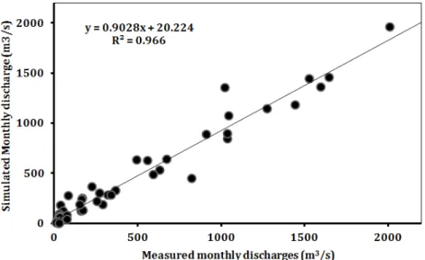
However, the similar thing is not reflected in the observed runoff data. It is assumed that there are prob- ably uncertainties in the data. From the scatter plots of the monthly measured and simulated river discharges of the Xebangfai@bridge station during the periods of discharge model calibration (2001-2005) and discharge model validation (2006-2010) are shown in Figure 6 and
7 below respectively. Both of the scatter plots represent relatively good R
2values: 0.970 and 0.966.
From Table 2, the value of Nash-Sutcliffe efficiency (E
NS) commonly ranges from 0-1. In the previous re- search, Saleh et al., (2004), indicated that the better prediction of model should be greater than 0.65 (E
NS>
0.65), whereas lower (E
NS) values are generally regarded as a poor model prediction. In addition to Moriasi et al.
Figure 6. Scatter plot of the monthly discharges for the calibration period (2001-2005).
Figure 7. Scatter plot of the monthly discharges for the validation period (2006-2010).
(2007) indicated that the simulations of SWAT model in term of monthly time are generally able to decide accept- able value when (E
NS) value is bigger than 0.5. According to these suggestions, the result of SWAT model in this study on river discharge simulation of the Xe Bang Fai river basin is very good in the calibration period of (E
NS).
5. Impact of Future Climate Change
The impact of future climate change has a potential threat on water resources, which has become a subject de- bated globally for decades (Arnell, 1999). The variability of climate will effect river runoff in the basin. Recently, IPCC’s scientists study found that climate change has affected the operation and function of existent water foundation and water management (Parry, 2007). The previous researches of IPCC-Intergovernmental Panel on Climate Change on estimation of climate change impact on water resources (Bates et al., 2008), with also a tech- nical paper on climate change and water (Kundzewicz et al., 2008). According to several researches provide a significant basis to understand the climate change impact on river watersheds. In addition, numerous researches have studied variations in climate change, which associ- ates with main hydrological system in the Mekong River Basin (Delgado et al., 2012; Räsänen et al., 2012). In addition to the climate change impact on hydrological system of Mekong River (Västilä et al., 2010; Piman et al., 2013) under various suppositions about the future of the Mekong River Basin (MRB).
This research is the river discharge simulation based on the climate change scenarios in the Xe Bang Fai river basin by 2030, and estimates the uncertainty of future climate projections. The climate model was generated by RCP6.0 simulations from 4th intergovernmental Panel on Climate Change (IPCC) (IPCC, 2014) assessment to test how the climate is likely to change in the Xe Bang
Fai river basin, and also the effect of change on water resources in basin. The model provides primary evalu- ation of the potential impact of these changes on water resources (Eastham et al., 2008). In this research indi- cates that the amount of river discharge in the Xe Bang Fai river basin is increase under 2030 climate change scenarios (IPSL CM5A-MR 2030, GISS E2-R-CC 2030 and GFDL CM3 2030). However, since the basin area and volume of water in the basin is small, the impact on river discharge and water availability in the Xe Bang Fai river basin downstream is probably to be significant for both during the period of rainy and dry season. Based on the climate change scenarios in 2030, total annual runoff from the Xe Bang Fai river basin is likely to doubled in- crease more than 315 m
3/s of river discharges (Baird et al., 2015). According to the three climate change scenarios, runoff increase of the Xe Bang Fai river is estimated for overall catchments, generally resulting from increased runoff during the rainy season. Runoff in dry season is predicted to remain the same or doubled its previous dry season discharge that has trended dramatic impacts, changing the stream’s ecology and basically altering its relationship to local communities (Baird et al., 2015) 1) Climate Change Scenarios
For comparing the river discharge change based on
climate change scenarios, the climate change model of
three institutes, namely Institute Pierre-Simon Laplace
(IPSL), NASA Goddard Institute for Space Studies
(GISS) and Geophysical Fluid Dynamics Laboratory
(GFDL) were used for estimating river discharge change
in 2030 (IPSL CM5A-MR 2030, GISS E2-R-CC 2030
and GFDL CM3 2030) (Sperber et al., 2013). In this
study, the three climate models (IPSL CM5A-MR 2030,
GISS E2-R-CC 2030 and GFDL CM3 2030) were
generated by RCP6.0 scenario based on cooperating be-
tween Mekong River Commission (MRC) and Deutsche
Gesellschaft für Internationale Zusammenarbeit (GIZ)
GmbH. The configuration of the Xe Bang Fai Sub-basin is identically from MRC SWAT sub-basin, which the climate change factors from the regional model were ap- plied to the SWAT model of the Xe Bang Fai river basin.
The data of change factors generated in the project were acquired in a feature that is agreeable with the clarifica- tion of change factors usable for SWAT models in MRC (MRC, 2014a). In these tables, overall of the factors were given by the Lao National Mekong Committees (LNMCs) working with Mekong River Commission.
Therefore, this study on climate change impacts on hydrological response can be used as important informa- tion for water resources management and natural disaster protection. In addition, the hydrological model can be used for quantifying sediment transportation and water quality analysis, those of which are valuable for the sus- tainable development of the Lao PDR in the future.
2) Hydrological Response with Climate Change Scenarios
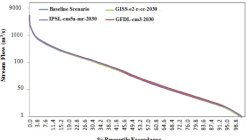
As shown in Figure 9, the comparison of monthly hy- drograph in the Xebangfai@bridge station between the
baseline and climate change scenarios indicates that river discharge generally increases in the middle of July and decreases in the middle of September in the future, while the highest of hydrograph is in the middle of August more than 1500 m
3/s (monthly-mean) and after in the middle of September, the hydrograph is straight down. In hydrograph of three scenarios (IPSL CM5A-MR 2030, GISS E2-R-CC 2030 and GFDL CM3 2030), their scenarios are higher than baseline in rainy season. With the discharges result of the (IPSL CM5A-MR 2030) obtained is lower in the dry season (Feb-May), which is lower than the baseline and during the wet season is above the baseline as shown in Figure 10. As shown in Figure 8, 9 and 10, the results of the three climate change scenarios (IPSL CM5A-MR 2030, GISS E2-R-CC 2030 and GFDL CM3 2030) are compared to baseline produced by SWAT model that included climate change factors applied to the original baseline data.
The scenarios of (IPSL CM5A-MR 2030), (GISS E2- R-CC 2030) and (GFDL CM3 2030) were represented in the discharge of both wet and dry seasons. While the result of three scenarios, the (IPSL-CM5A-MR 2030) has provided lower discharges in the dry season (Feb-
Figure 8. Comparing discharges of the climate change scenarios with baseline
May) than the baseline scenario, as the end of the wet season is above the baseline scenario. The flow of climate change scenarios generated more than 800 m
3/s of the monthly (July, August and September) with comparing the baseline scenario at the Xebangfai@bridge station as
shown in Table 3 and Figure 9. The peak discharge dur- ing these months of this area is commonly because of the southwest monsoon (wet season) in the middle of May to early October, which is a dominant phenomenon when air pressure is substantially low over Southeast Asia. In
Figure 9. Comparing monthly changes in discharge of the Xebangfai@bridge station of the climate changescenarios with baseline scenario.
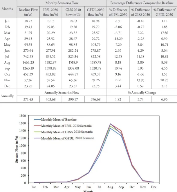
Table 3. Climate change scenarios, which effected in surface runoff.
Months
Monthy Scenarios Flow Percentage Differences Compared to Baseline Baseline Flow
(m3/s)
IPSL 2030 flow (m3/s)
GISS 2030 flow (m3/s)
GFDL 2030 flow (m3/s)
% Difference of IPSL 2030
% Difference of GISS 2030
% Difference of GFDL 2030
Jan 18.72 19.15 18.63 18.94 2.30 -0.48 1.18
Feb 19.43 19.03 19.28 19.79 -2.06 -0.77 1.85
Mar 21.75 20.29 23.32 25.57 -6.71 7.22 17.56
Apr 29.43 25.52 28.67 29.72 -13.29 -2.28 0.99
May 95.53 88.65 98.85 105.79 -7.20 3.84 10.74
Jun 270.64 277.91 282.24 278.87 2.69 4.29 3.04
Jul 742.35 835.52 825.34 822.58 12.55 11.18 10.81
Aug 1463.23 1582.87 1518.9 1585.78 8.18 3.80 8.38
Sep 1263.19 1398.89 1338.08 1320.78 10.74 5.93 4.56
Oct 452.39 493.82 444.89 459.39 9.16 -1.66 1.55
Nov 57.36 58.54 65.36 69.26 2.06 13.95 20.75
Dec 23.25 24.05 23.37 23.75 3.44 0.52 2.15
Annually Annually Scenarios Flow % Annually Change
371.43 403.68 390.57 396.68 1.82 3.74 6.96
addition to Lao PDR is influenced from heavy rainfall by citing some researches: Snidvongs et al., (2003); Eastham et al., (2008) and Västilä et al., (2010); SONNASINH (2009); MRC (2015). The severe change scenario is over- all of three scenarios as (IPSL CM5A-MR 2030), (GISS E2-R-CC 2030) and (GFDL CM3 2030), while the amount of monthly high surface runoff which the dura- tion of the monthly high surface runoff also increases and expands until the first week of September. The stream flow comparison is given in Table 3 and Figure 9.
According to the results of Table 4 and Figure 10, they found that in the starting point they respond the infor- mation, and during the water resources availability in the
dry season is very little throughout the years, of which discharge is lower than 20 m
3/s, which is able to result ex- treme drought in this southern part of region, but during the wet season in this region is under water. As the Table 3 shows the stream flow of the Xe Bang Fai river basin for the year 2030 based on the future climate change factor of three institutes recommended river discharge taking into account, the climate change is resulted in as well as in normal conditional distribution.
Table 4. Monthly averages of scenarios 2030 in the dry season of the Xebangfai@bridge station (river discharge gauge station).
Dry Season Monthly Mean of Baseline (m3/s)
Monthly Mean of IPSL 2030 (m3/s)
Monthly Mean of GISS (m3/s)
Monthly Mean of GFDL (m3/s)
Nov 57.36 58.54 65.36 69.26
Dec 23.25 24.05 23.37 23.75
Jan 18.72 19.15 18.63 18.94
Feb 19.43 19.03 19.28 19.79
Mar 21.75 20.29 23.32 25.57
Apr 29.43 25.52 28.67 29.72
Figure 10. Monthly mean plots in the dry Season of overall scenarios and baseline.
6. Conclusion
In this study, the hydrological response of Xe Bang Fai river basin to future climate change scenarios is evaluated by applying the dataset of exploratory climate change factors. The statistical data of climate change is applied to the SWAT model in the Xe Bang Fai river basin. The present-day monthly hydrographs are successfully cali- brated and validated by using the SWAT model in the Xe Bang Fai river basin. The results are represented with the possible gauging the calibration and validation model for two periods as follows: 2001-2005 and 2006-2010. In this study, the results of the monthly simulation R
2and E
NSare 0.970 and 0.967 during the calibration periods and are also 0.966 and 0.960 during the validation pe- riod.
In this study, the baseline results of calibrated hydro- logical model during the period 2001-2010 was used to compare the river charge change of the Xe Bang Fai river basin with the scenarios of climate change, namely IPSL CM5A-MR 2030, GISS E2-R-CC 2030 and GFDL CM3 2030 for forecasting surface runoff in the year 2030. The simulated runoffs based on the three models of different climate-simulated precipitations are widely different each other. For instance, the average monthly changes (specifically Percentage differenced rank) are (-13.29 to 12.55) for IPSL CM5A-MR, (-2.28 to 13.95) for GISS E2-R-CC and (1.18 to 20.75) for GFDL CM3 2030 scenario respectively. Notwithstanding the data uncertainty (Abbaspour et al., 2004), the SWAT model can generate good simulation results of monthly time processes which are potentially valuable for water re- sources management in the Xe Bang Fai river basin as well as the whole sub-watershed in the Mekong river ba- sin.
According to these results of climate change scenarios, the model can be used as valuable information for water resources management and natural disaster protection
in the future. The results of climate change model’s sce- narios can be also used for better information in future researches. Furthermore the SWAT model is able to be applied as the standard model for future study on sedi- ment yield and water quality analysis. Additionally, this study is able to be conducted in the planning on hydropower dam construction irrigation system, levee and flood disaster risk management in the future which results of research are valuable for the sustainable country development under the 8th National Social-Economic Development Plan (2016-2020) of Lao PDR.
Notes
1) HRU is “the smallest spatial unit of the model and the stan- dard HRU definition approach lumps all similar land uses, soils, and slopes within a sub-basin based upon user-defined thresholds” (Kalc et al., 2015)
2) SUFI-2 is “the algorithm for using calibration and validation model in SWAT-CUP” (Abbaspour, 2015)
3) SWAT-CUP is “a calibration/uncertainty analysis or sensitiv- ity program interface for SWAT model” (Abbaspour, 2015)
References
Abbaspour, K. C., 2015, SWAT-Calibration and uncertainty programs, a user manual, Eawag: Swiss Federal insti-
tute of aquatic science and technology, 103.
Abbaspour, K. C., Johnson, C. A., & Van Genuchten, M.
T., 2004, Estimating uncertain flow and transport parameters using a sequential uncertainty fitting procedure, Vadose Zone Journal, 3(4), 1340-1352.
Abbaspour, K. C., Yang, J., Maximov, I., Siber, R., Bogner, K., Mieleitner, J., ... & Srinivasan, R., 2007, Model- ling hydrology and water quality in the pre-alpine/
alpine Thur watershed using SWAT, Journal of hy-
drology, 333(2), 413-430.
Andersson, L., Wilk, J., Todd, M. C., Hughes, D. A., Earle,
A., Kniveton, D., ... & Savenije, H. H., 2006, Im- pact of climate change and development scenarios on flow patterns in the Okavango River, Journal of
Hydrology, 331(1), 43-57.
Arabi, M., Frankenberger, J. R., Engel, B. A., & Arnold, J. G., 2008, Representation of agricultural conservation practices with SWAT, Hydrological Processes, 22(16), 3042-3055.
Arnell, N. W., 1999, Climate change and global water re- sources. Global environmental change, 9, S31-S49.
Arnold, J. G., Srinivasan, R., Muttiah, R. S., & Williams, J.
R., 1998, Large area hydrologic modeling and as- sessment part I: Model development, Journal of the
American Water Resources Association, 34, 73-89.
Baird, I. G., Shoemaker, B. P., & Manorom, K., 2015, The people and their river, the World Bank and its dam:
Revisiting the Xe Bang Fai River in Laos. Develop-
ment and Change, 46(5), 1080-1105.
Bates, B., Kundzewicz, Z. W., Wu, S., & Palutikof, J., 2008,
climate change and Water: technical Paper vi. Inter-
governmental Panel on Climate Change (IPCC).Bazzaz, F. A., & Sombroek, W. G. (Eds.), 1996, Global cli-
mate change and agricultural production: direct and indirect effects of changing hydrological, pedological, and plant physiological processes. Food & Agriculture
Org.Borah, D. K., & Bera, M., 2004, Watershed-scale hydrologic and nonpoint-source pollution models: Review of applications, Transactions of the ASAE, 47(3), 789.
Champathangkham, S., & Pandey, A., 2013, Hydrological Modelling of Xebangfai river basin in Lao PDR: A Case Study Using SWAT Model, Journal of Indian
Water Resources Society, 33(2).
Craig, R. K., 2010, ‘Stationarity is Dead’-Long Live Trans- formation: Five Principles for Climate Change Ad- aptation Law. Harvard Environmental Law Review,
34(1), 9-75.
Debele, B., Srinivasan, R., & Parlange, J. Y., 2008, Coupling upland watershed and downstream waterbody hy- drodynamic and water quality models (SWAT and CE-QUAL-W2) for better water resources manage- ment in complex river basins, Environmental Model-
ing & Assessment, 13(1), 135-153.
Delgado, J. M., Merz, B., & Apel, H., 2012, A climate-flood link for the lower Mekong River. Hydrology and
Earth System Sciences, 16(5), 1533-1541.
Eastham, J., Mpelasoka, F., Mainuddin, M., Ticehurst, C., Dyce, P., Hodgson, G., ... & Kirby, M., 2008, Me- kong river basin water resources assessment: Impacts of climate change.
Fewtrell, D., & Kay, L., 2008, Health impact assessment for sustainable water management, Water Intelligence
Online, 7, 9781780401874.
Gassman, P. W., Reyes, M. R., Green, C. H., & Arnold, J.
G., 2007, The soil and water assessment tool: histori- cal development, applications, and future research directions, Transactions of the ASABE, 50(4), 1211- 1250.
Grønsten, H. A., & Lundekvam, H, 2006, Prediction of surface runoff and soil loss in southeastern Norway using the WEPP Hillslope model, Soil and Tillage
Research, 85(1), 186-199.
IPCC, 2014, Climate Change 2014–Impacts, Adaptation and
Vulnerability: Regional Aspects. Intergovernmental
Panel on Climate Change, Cambridge University Press.Kalcic, M.M., Chaubey, I. and Frankenberger, J., 2015, De- fining Soil and Water Assessment Tool (SWAT) hy- drologic response units (HRUs) by field boundaries,
International Journal of Agricultural and Biological Engineering, 8(3), pp.69-80.
Kottelat, M., 2015, The fishes of the Nam Theun and Xe Bangfai drainages, Laos. Hydroécologie Appliquée.
Kundzewicz, Z. W., Mata, L. J., Arnell, N. W., Döll, P., Ji- menez, B., Miller, K., ... & Shiklomanov, I., 2008, The implications of projected climate change for freshwater resources and their management.
Lao Embassy, 2011, Two Tropical Storms Caused Serious Floods in Laos, Report on Flood in Laos 2011. Acces- sible at http://laoembassy.com/Flood%20in%20 Laos%202011.pdf
LNMC, 2011a, Water Resources Study in the Xe Bang Fai River Basin, Lao National Mekong Committee Re-
port on Lao National Pilot Study 2011.
LNMC, 2011b, Xe Bang Fai Water Resources and Flood Mapping, Lao National Mekong Committee Report
on Lao National Pilot Study 2011.
Morgan, R. P. C., 2001, A simple approach to soil loss predic- tion: a revised Morgan–Morgan–Finney model,
Catena, 44(4), 305-322.
Moriasi, D. N., Arnold, J. G., Van Liew, M. W., Bingner, R. L., Harmel, R. D., & Veith, T. L., 2007, Model evaluation guidelines for systematic quantification of accuracy in watershed simulations, Transactions of
the ASABE, 50(3), 885-900.
MRC, 2006, Annual Flood Report 2005, Mekong River Commission, Flood Management and Mitigation Programme (FMMP), Vientiane, Lao PDR, 82.
ISSN 1728 3248. Accessible at http://www.mrcme- kong.org/assets/Publications/basin-reports/Annual- Mekong-Flood-Report-2005.pdf
MRC, 2008, Annual Flood Report 2007, Mekong River Commission, Flood Management and Mitigation Programme (FMMP), Vientiane, Lao PDR, 96.
ISSN 1728 3248. Accessible at http://www.mrcme- kong.org/assets/Publications/basin-reports/Annua- Mekong-Flood-Report-2007.pdf
MRC, 2009, Annual Flood Report 2008, Mekong River Commission, Flood Management and Mitigation Programme (FMMP), Vientiane, Lao PDR, 104.
ISSN 1728 3248. Accessible at http://www.mrcme- kong.org/assets/Publications/basin-reports/Annual- Mekong-Flood-Report-2008.pdf
MRC, 2010, Hydrological and Flood Hazards in the Focal Areas, Mekong River Commission, Flood Manage- ment and Mitigation Programme, Component 2:
Structural Measures & Flood Proofing in the Lower Mekong Basin, Final Report, Vol.2B. Accessible at http://cnmc.gov.kh/cnmc/jdownloads/Reports/
V2B_Hydr_Haz_&_FLood_Haz_Focal_Areas_
final_FMMP.pdf
MRC, 2011, Annual Flood Report 2010, Mekong River Commission, Flood Management and Mitigation Programme (FMMP), Vientiane, Lao PDR, 79.
ISSN 1728 3248. Accessible at http://www.mrcme- kong.org/assets/Publications/basin-reports/Annual-
Mekong-Flood-Report-2010.pdf
MRC, 2014a, Exploratory analysis of climate change factor ranges, Mekong River Commission, The-Final Re- port, Revision 3.1, June 2014.
MRC, 2015, Annual Mekong Flood Report 2013, Office of the Secretariat in Phonom Penh, Mekong River Commission (MRC), Phonom Penh. Accessible at http://www.mrcmekong.org/assets/Publications/
basin-reports/Annual-Mekong-Flood-Report-2013.
Nash, J. E., & Sutcliffe, J. V., 1970, River flow forecasting through conceptual models part I-A discussion of principles. Journal of hydrology, 10(3), 282-290.
Neitsch, S. L., Arnold, J. G., Kiniry, J. R., Willams, J. R., 2011, Soil and Water Assessment Tool: the theoretical
documentation (version 2009), Grassland, Soil and
Water Research Laboratory- Agricultural Research Service-Blackland Research Center-Texas AgriLife Research.NT2, 2003, Environment Assessment and Management Plan, NAM THEUN II (NT2) Power Company Ltd., EcoLao; Norplan, Volume 3-Annexes.
Parry, M. L. (Ed.), 2007, Climate change 2007-impacts, adap-
tation and vulnerability: Working group II contribu- tion to the fourth assessment report of the IPCC (Vol.
4). Cambridge University Press.
Piman, T., Lennaerts, T., & Southalack, P., 2013, Assessment of hydrological changes in the lower Mekong Basin from Basin-Wide development scenarios. Hydrologi-
cal Processes, 27(15), 2115-2125.
Räsänen, T. A., Koponen, J., Lauri, H., & Kummu, M., 2012, Downstream hydrological impacts of hydro- power development in the Upper Mekong Basin.
Water Resources Management, 26(12), 3495-3513.
Rosenthal, W. D., Srinivasan, R., & Arnold, J. G., 1995, Alternative river management using a linked GIS- hydrology model, Transactions of the ASAE, 38(3), 783-790.
Saleh, A., & Du, B., 2004, Evaluation of SWAT and HSPF within BASINS program for the upper North Bosque River watershed in central Texas, Transac-
tions of the ASAE, 47(4), 1039.
Santhi, C., J. G. Arnold, J. R. Williams, W. A. Dugas, R.
Srinivasan, and L. M. Hauck., 2001, Validation of the SWAT Model on A Large River Basin with Point and Nonpoint Sources. J. American Water Resourc- es Association. 37(5), 1169-118.
Setegn, S. G., Srinivasan, R., Melesse, A. M., & Dargahi, B., 2010, SWAT model application and prediction un- certainty analysis in the Lake Tana Basin, Ethiopia,
Hydrological Processes, 24(3), 357-367.
Shao, H., & Chu, L., 2013, Water‐quality Engineering in Natural Systems: Fate and Transport Processes in the Water Environment, CLEAN–Soil, Air, Water,
41(8), 829-830.
Sheng, X. B., Sun, J. Z., & Liu, Y. X., 2003, Effect of land- use and land-cover change on nutrients in soil in Bashang area, China, Journal of environmental sci-
ences, 15(4), 548-553.
Shrestha, B., Babel, M. S., Maskey, S., Griensven, A. V., Uhlenbrook, S., Green, A., & Akkharath, I., 2013, Impact of climate change on sediment yield in the Mekong River basin: a case study of the Nam Ou ba- sin, Lao PDR, Hydrology and Earth System Sciences,
17(1), 1-20.
Sioudom, K., 2013, Basin Profile for the Nam Theun/Nam Kading, Nam Hinboun and Xe Bang Fai, Lao PDR.
Project report: Challenge Program on Water &Food Mekong project MK3 “Optimizing the manage- ment of a cascade of reservoirs at the catchment lev- el”. ICEM – International Centre for Environmental Management, Hanoi Vietnam, 2013.
Snidvongs, A., Choowaew, S., & Chinvanno, S., 2003, Impact of climate change on water and wetland resources in Mekong river basin: Directions for pre- paredness and action, Change, 2, 2.
SONNASINH, V., 2009, Lao PDR’s country flood report for 2008, Mekong River Commission, 68.
Sperber, K. R., Annamalai, H., Kang, I. S., Kitoh, A., Moise, A., Turner, A., ... & Zhou, T., 2013, The Asian sum- mer monsoon: an intercomparison of CMIP5 vs.
CMIP3 simulations of the late 20th century. Cli-
mate Dynamics, 41(9-10), 2711-2744.
Van Liew, M. W., Arnold, J. G., & Garbrecht, J. D., 2003, Hydrologic simulation on agricultural watersheds:
Choosing between two models, Transactions of the ASAE, 46(6), 1539.
Västilä, K., Kummu, M., Sangmanee, C., & Chinvanno, S., 2010, Modelling climate change impacts on the flood pulse in the Lower Mekong floodplains, Jour-
nal of Water and Climate Change, 1(1), 67-86.
Wang, G., Yang, H., Wang, L., Xu, Z., & Xue, B., 2014, Us- ing the SWAT model to assess impacts of land use changes on runoff generation in headwaters, Hydro-
logical Processes, 28(3), 1032-1042.
Wu, W., Hall, C. A., & Scatena, F. N., 2007, Modelling the impact of recent land-cover changes on the stream flows in northeastern Puerto Rico, Hydrological Pro-
cesses, 21(21), 2944-2956.
Zhang, Y., Xia, J., Shao, Q., & Zhai, X., 2013, Water quan- tity and quality simulation by improved SWAT in highly regulated Huai River basin of China, Sto-
chastic Environmental Research and Risk Assessment, 27(1), 11-27.
교신: Virasith Phomsouvanh(이메일:ph_virasith@hot- mail.com)
Correspondence: Virasith Phomsouvanh (e-mail: ph_vira- [email protected])