• 검색 결과가 없습니다.

The Composition and Characteristics of the Coastal Space of Chongqing: An Interpretative Study Based on the Ten-year Draft Construction Plan of the Alternate Capital

N/A
N/A
Protected

Academic year: 2021

Share "The Composition and Characteristics of the Coastal Space of Chongqing: An Interpretative Study Based on the Ten-year Draft Construction Plan of the Alternate Capital"

Copied!
9
0
0

로드 중.... (전체 텍스트 보기)

전체 글

(1)

ORIGINAL ARTICLE

The Composition and Characteristics of the Coastal Space of Chongqing: An Interpretative Study Based on the Ten-year Draft Construction Plan of the Alternate Capital

Ming-liang Kong, Chun-lan Du, Hua-song Mao, Jun-hua Zhang

1)

, Kwang-min Ham

2)

, Jo Hyunju

3)*

Faculty of Architecture and Urban Planning, Chongqing University, China

1)

Dept. of Landscape Architecture, Chiba University, Japan

2)

Dept. of Landscape Architecture, Tsinghua University, China

3)

East coastal Life Sciences Institute Gangneung-Wonju National University, Gangneung 25457, Korea

Abstract

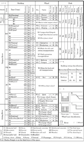
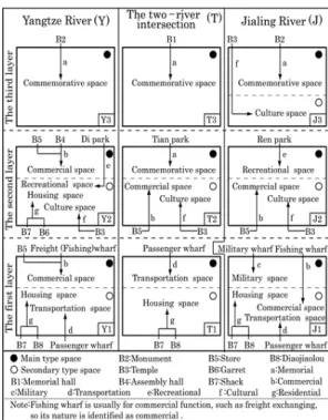
This study focused on the buildings, wharves, and parks of the coastal space of Chongqing based on the ten-year construction draft plan of the alternate capital. From an investigation of these three components according to their type, structure, terrain, function, spatial layer, and so on, the following conclusions were drawn: The coastal space of Chongqing is composed of three different layers. The first and second layers consisted of the two-river intersection basin with the transportation and commemorative space at the center, the Yangtze River basin with the commercial space at the center, and the Jialing River with the military and recreational space at the center. The third-layer is centered around the commemorative space. The coastal space of Chongqing manifested the limitations of the times, its traditionality, and an integrated development process.

Key words : Coastal space, Building, Wharf, Park, Composition, Characteristics

1. Introduction 1)

With the end of the Sino-Japanese War in 1945, the Nationalist government of China made a ten-year plan for the construction of an alternate capital in Chongqing (hereafter referred to as the draft plan).

Formulated in 1946, the draft plan represented the first overall planning initiative and an important milestone in the history of the urban development of Chongqing(Wei, 1991). The period of the draft plan marked the transition of Chongqing from a “wartime

capital” to the “permanent alternate capital,” and the beginning, in modern times, of the urban development of Chongqing(Chen et al., 2004).

Chongqing has always been the transport hub and economic and cultural center of southwest China (Fig. 1), and became its political and military center as well when the Nationalist government moved its capital to Chongqing after the outbreak of the Sino-Japanese war in 1937 because of its location and harbor environment(Wu, 2009). Chongqing epitomizes urban development in southwest China,

Received 30 March, 2016; Revised 7 May, 2016;

Accepted 9 May, 2016

*

Corresponding author : Jo Hyunju, East coastal Life Sciences Institute Gangneung-Wonju National University, Gangneung 25457, Korea Phone : +82-33-640-2639

E-mail : [email protected]

ⓒ The Korean Environmental Sciences Society. All rights reserved.

This is an Open-Access article distributed under the terms of the Creative Commons Attribution Non-Commercial License (http://

creativecommons.org/licenses/by-nc/3.0) which permits unrestricted

non-commercial use, distribution, and reproduction in any medium,

provided the original work is properly cited.

(2)

and its coastal space is a concentrated reflection of the political economy and regional culture of Chongqing(Deng, 1982; Kong et al., 2011b). However, the coastal space of Chongqing (hereafter referred to as the CSC) has for the first time seen great changes as a result of the draft plan in its traditional composition, natural environment, and physical characteristics, for example. Therefore, as the first step, this study will focus on the changes in the CSC’s composition and characteristics, as well as the Nationalist government’s thinking about its draft plan. It can also serve as the basis for the CSC construction now under way.

Fig. 1. Macro location map.

At the same time, China is rapidly urbanizing and foreign cultures are penetrating into and spreading across China, resulting in convergence of the internal and external forms of cities and cultural faults in Chinese cities. Chongqing has the most representative mountainous landform in western China. Since the Reform and Opening-up in 1978, and the establish -ment of the fourth municipality under direct administration of the central government in 1997, Chongqing’s external space (CSC), including public green space, riverside high-speed highways, and nearly 20 bridges across the Jialing River and the Yangtze River, is growing rapidly under great policy support from the state. At meantime, high-speed

economic growth has created dramatic changes in the riverside park green land system, the transport environment system, and the ecological layout of Chongqing. It will be beneficial for the renovation and progress of the urban green land system if we could find a model for the healthy evolution and progress of the regional riverside spatial form in the modern context and thus provide scientific references for the healthy evolution and progress of the city.

Fig. 2. Regional distribution of coastal.

The process of change in the coastal space(Kong et

al., 2011a), the composition and characteristics of the

space in the initial period, when the harbor was

opened(Kong et al., 2011b), land utilization(Lan,

2001), hydrological characteristics(Chen, 2011),

wharf form(Deng, 2007), nature of the harbor

(Zhang, 2010), harbor trade(Ma et al., 2007), and

landform have been analyzed in previous CSC

studies(Xi, 1993). Moreover, the records of Chongqing

provide summarized accounts of the state of coastal

buildings, as well as a narrative of the cultural aspects

of the draft plan(Chongqing, 1994). However, no

comprehensive and systematic analysis on the

research of the coastal space has been carried out in

the draft plan. This study seeks to fill this research

(3)

gap by examining the composition and characteristics of the CSC, as shown in the draft plan, and investigating the harbor environment and historical background of Chongqing.

1.1. The summary of the draft plan

The Nationalist government established the Const -ruction Planning Commission of the Alternate Capital at the end of 1945, and finalized the draft plan in April 1946. The overall plan related to transportation, municipal administration, building construction, cultural education, etc required for the construction of the CSC.

The draft plan contains 16 chapters “General Remarks,” “The Building Code,” “Harbor Equipment,”

“The Green Space System,” and so on.

2. Research object and methods

2.1. Research object

After it was established as a city in 1927, Chongqing retained the ruins of the city gates and city walls. According to the draft plan, the area of the CSC is the coastal space, which is the middle area from the ruins of city gates except Tongyuan Gate and city walls to the riverbanks. Researchers state the coastal space was divided into the two-river intersection basin (CTZone), the Yangtze River basin (DSZone, TPZone, CQZone, JZZone, NJZone), and the Jialing River basin (QSZone, LJZone)(Lan, 2001), as shown in Fig. 2. Because of space constraints, this article contains an analysis of only three important components of the draft plan: buildings, wharves, and parks.

2.2. Research methods

Statistical data with a bearing on the study were collected from the draft plan as well as previous studies on the spatial layers of the coast, other classified data, and so on(Kong et al., 2011a; Kong et al., 2011b; Deng, 2007). Fig. 3 and Table 1 were

constructed on the basis of these data. Next, the distribution and composition characteristics of the buildings, wharves, and parks in the coastal space were determined by a structural analysis of these components. The reason behind these characteristics was investigated based on the coastal landform and hydrologic condition of Chongqing. Finally, the composition of the overall coastal space and its characteristics were comprehensively analyzed against the historical background of the CSC, the vision of the draft plan, and so on.

Fig. 3. Space layer distribution of buildings, wharves and parks.

3. Composition and characteristics of the coastal space

According to the explanation of distribution of the buildings, wharves and parks in the draft plan, and the previous studies of layers of the coastal space (Kong et al., 2011b; Long et al., 2011), buildings exist in each of the three coastal space layers, all of the wharves are in the first layer of the coastal space, all of the parks are in the second layer of the coastal space (Fig. 3).

From the draft we have known that the riverside

space in Chongqing is made up of buildings, wharfs,

parks, roads, bridges, and wastelands, etc. Based on

previous studies on the architectural types, wharf

distribution, park categories, etc., in Chongqing’s

riverside space, this article focuses on the forms,

(4)

components and features of the riverside space, and analyzes the architectural distribution and materials, the types and distribution of wharfs, and the coverage and locations of parks, etc.

3.1. Buildings

It was specified in the draft plan(P178) that there were eight types of buildings in the CSC: memorial hall, monuments, temples, assembly halls, stores, garrets, shacks, and the Diaojiaolou. The structures, materials and spatial layer of the buildings are shown in Table 1-1.

The first layer: The two-river intersection basin is characterized by the wooden Diaojiaolou with the

Table 1. Statistics of types and composition elements of buildings, wharves and parks

bundled structure and wooden shacks with walls made of bamboo rafters. The Yangtze River basin, with the same composition as the two-river intersection basin, has wooden stores with walls made of bamboo rafters in its DSZone, TPZone, CQZone, and JZZone.

The Jialing River basin also has the same compo -sition as the two-river intersection basin. The second layer: The two-river intersection basin is characterized by masonry stores and temple (Longtou), all stone- earth structures. The Yangtze River basin, with the same composition as the two-river intersection basin, has wooden shacks with walls made of bamboo rafters, masonry assembly halls (Fujian, Jiangxi, etc.), and garrets made of stone earth in its DSZone, TPZone, CQZone, and JZZone. The Jialing River basin also has the same composition as the two-river intersection basin. The third layer: the two-river intersection basin is characterized by the Chaotian memorial hall, and the Yangtze River basin by monuments (Dongshui, Taiping, etc.); the memorial hall and the monuments are reinforced-concrete structures. The Jialing River basin is similar to the Yangtze Riverbasin in its composition characteristics; its Baolun temple, constructed with stone-earth masonry, is located in LJZone.

The distribution characteristics of the CSC buildings are as follows: The first layer of the coastal space mainly consists of the wooden Diaojiaolou and shacks, as well as a few stores. The second layer consists of a large number of masonry stores and temples, as well as a few wooden shacks, masonry assembly halls and garrets. The third layer consists of a large number of monuments made by reinforced concrete, as well as few memorial hall made by reinforced concrete and masonry temples.

It is evident from the hydrologic condition of the

CSC that its water level in the dry season is quite

different from what it is in the rising flood

stage(Chen, 2011). The waterside region is not

suitable for permanent buildings. Wooden Diaojiaolou,

(5)

shacks, and stores have the mobility required for momentary relocation(Chongqing, 1994), so they are distributed in the first-layer coastal space. This feature of buildings in this layer satisfies the hydrologic conditions of rivers in Chongqing. In the draft plan, coastal buildings are classified according to their structure and materials used (Table 1-2).

According to the plan (P183), “The Diaojiaolou and shacks along the river are used by low-status building residents; it is inappropriate for them to be built near temples, assembly halls, or other medium buildings.

It is forbidden to build inferior buildings around the advanced buildings commemorating the Sino-Japanese War.” This was the basis on which the coastal buildings, their users, and the coastal space were classified by the Nationalist government. Thus, the coastal space presents the distribution characteristics of the transformation from the inferior wooden buildings of the first layer to advanced reinforced- concrete buildings of the third layer.

In summary, the coastal architectural space in Chongqing is characterized by three different types of buildings: wooden buildings in the first layer, masonry buildings in the second layer, and reinforced -concrete buildings in the third layer. The distribution characteristics of the coastal buildings not only satisfy the hydrologic conditions of the rivers in Chongqing but also reflect the division of the hierarchical system in the coastal architectural space.

3.2. Wharves

According to the draft plan(P158), the CSC has 17 wharves. Based on the draft plan and previous studies(Kong et al., 2011a; Deng, 2007), wharves can be divided into along-shore and jetty types (based on type of plane), ramp and vertical types (based on terrain) (Table 1-3), passenger, freight, fishing (for use), and military types (based on function). The distribution, plane type, terrain and function of coastal wharves are presented in Table 1-1.

W1, the along-shore- and ramp-type wharf in the two-river intersection basin is the largest in the whole basin. W2 and W3 have the same plane (along shore) and terrain (ramp) types as W1. The three wharves are all passenger wharves. W4 (DSZone) and W11 (NJZone) in the Yangtze River basin have a jetty-type plane and a vertical-type terrain. All other wharves in this basin, except W4 and W11, have the along-shore type of plane and the ramp type of terrain. Except W5 (DSZone) and W10 (JZZone) are passenger wharves ,and W8 (CQZone) is a fishing wharf, all other wharves are freight wharves.

In the Jialing River basin, W14 (a passenger wharf) of QSZone and W17 (a fishing wharf) of LJZone have the along-shore type plane and the ramp type of terrain. All other wharves in the basin have a jetty-type plane and a vertical-type terrain, and function as military wharves.

Thus, the distribution characteristics of CSC wharves are as follows: All wharves in the two-river intersection basin are along-shore passenger wharves and have a ramp-type terrain. The Yangtze River basin is for the most part characterized by along-shore freight wharves, but it also has a small number of along-shore passenger and fishing wharves. Most wharves in the basin have the ramp topography. The Jialing River basin is characterized by a majority of jetty military wharves and a small amount of along-shore passenger and fishing wharves.

Most wharves in the basin have the vertical-type terrain.

The coastal topography of Chongqing is marked

by close inland wharves that look like river harbors,

most of them formed as ramps(Chen, 2011). The

water level changes greatly, and the along-shore

wharves are suitable as river wharves in the middle

and upper reaches(Zhang, 2010). Because of these

two factors, the two-river intersection basin and the

Yangtze River basin are mainly characterized by

along-shore wharves with the ramp-type terrain. The

(6)

jetty wharf with a big tonnage and deep draught is most suitable as a large-scale vertical wharf(Zhang, 2010). W4 and W11 in the Yangtze River basin and W12, W13, W15, and W16 in the Jialing River basin are large-scale wharves, and conform to the character -istics of jetty wharves. Regarding the regional culture, seventeen coastal city gates symbolizing

“nine palaces and eight diagrams” in Chongqing were gradually demolished in 1927(Kong et al., 2011b).

The Nationalist government expected to replace the city gates with wharves that symbolize Chongqing city as the “everlasting impenetrable fortress.”

(Chongqing, 1994) This explains why the number of coastal wharves envisaged in the draft plan was determined as 17. The wharves were considered as an extension of the traditional culture of the coastal region of Chongqing.

In summary, the coastal wharf space in Chongqing consisted of three basins with different character -istics: the two-river intersection basin with primarily along-shore passenger wharves, the Yangtze River basin with primarily along-shore freight wharves, and the Jialing River basin with primarily jetty military wharves. The distribution characteristics of the wharves not only conform to the coastal topography and wharf type but also reflect the preservation of the traditional regional culture in the coastal wharf space.

3.3. Parks

For the first time ever, a green space plan was proposed for the CSC, and three parks were to be constructed according to the draft plan(P90). The region, name, area, terrain, style, form, planar configuration, main functional and facilities of the parks are shown in Table 1-1.

The Tian Park with an area of 2000 m

2

was located in the coastal ramp terrain in the two-river intersection basin. It was a Western-style terrace park with a symmetrical planar configuration, and its major functional facilities were a statue of liberty and a war

monument. The Di Park with an area of 2600 m

2

was located in NJZone of the Yangtze River basin. It had the same terrain, style, form, and plane layout of the Tian Park, and its major functional facility was a swimming pool. The Ren Park with an area of 9000 m

2

was located at the intersection of LJZone and QSZone in the Jialing River basin, in the coastal plane terrain. The largest among the three parks, the Ren Park had a natural landscape with a natural Western-style planar configuration. Its major functional facility was a sports square and pavilion.

In the draft plan(P97), the coastal parks in Chongqing were designed “as multi-style, purely Western parks, which were intended to showcase Chongqing as a modern metropolis.” Therefore, it was decided to design the three coastal parks as typically Western- style parks, in both style and form. Most coastal land areas in Chongqing had a ramp terrain(Xi, 1993).

This explained why both the Tian Park and the Di Park had a terrace form. The Jialing River basin with a broad land area rarely had a plain terrain in the coastal region. This explained why the area of Ren Park was far greater than that of the other two parks.

This is also the reason the only natural landscape also satisfied the “multi-style” standard in the draft plan.

The Tian Park had a statue of liberty and a war monument, which show that the Tian Park was a commemorative park. The Di Park and the Ren Park had a swimming pool and a sports square for recreation, which show that the two parks were recreational parks. The three parks were respectively named as “Tian,” “Di,” and “Ren” in the draft plan based on Taoism, the traditional Chinese culture, implying that the three parks represented “the three fundamentals”: good crops, good weather, and peace(Chongqing, 1994). Thus, while the coastal parks were Western in style, their naming methods were consistent with the traditional Chinese culture.

In summary, the parks in the coastal space in the

two-river intersection basin were commemorative

(7)

parks, and those in the Yangtze River basin and the Jialing River basin were recreational parks. Overall, the design standard and topographical conditions of the coastal parks showed a good combination of Chinese tradition and Western style.

3.4. Comprehensive investigation

The above analysis of the space distribution features of buildings, wharves and parks are arranged in Fig. 4, which is used to do the comprehensive analysis and investigation of the overall coastal space.

Since the Ming dynasty, the two-river intersection basin had been the water transportation hub and the sole waterway for senior officials to go back and forth from Chongqing, and it was mainly used for passenger transportation, which decided that the first layer of the two-river intersection basin (T1) centered around the transportation space. As mentioned in sections 3.1 and 3.2, the Chaotian memorial hall in the third layer was a coastal commemorative building, and the first layer of the two-river intersection basin was used as the traffic center of going back and forth from Chongqing. Against the historical background of war, a commemorative park was set up in the second layer of the coastal space to further enhance the height of the commemorative meaning, which showed that the second layer (T2) of the two-river intersection basin took the commemorative space as the center.

Since 1932, the annual freight volume of the harbors in the Yangtze River basin had accounted for more than 80% of the Chongqing freight(Ma et al., 2007), and it was the main business traffic channel in the coastal area of Chongqing, and the first layer (Y1) of the Yangtze River basin therefore centered around the commercial space. As mentioned in section 3.1, DSZone, TPZone, CQZone, and JZZone in the Yangtze River basin provided the sole assembly hall for the purpose of trade in the coastal

space, which also reflected that the second layer (Y2) of the Yangtze River basin similarly centered around the commercial space.

Since the outbreak of Sino-Japanese war in 1937, the Jialing River basin was taken as the distribution center of military materials. As narrated in the draft plan(P170), “the military wharf with QSZone and LJZone as the centre is established for the timely transportation of material in wartime,” which shows that the first layer of Jialing River basin (J1) centered around the military space. As shown in section 3.3, the Nationalist government considered Chongqing as a standard to measure the modernization of the region, and the recreational Ren Park was also the largest park in the coastal space, which shows that the second layer of the Jialing River basin (J2) centered around the recreational space.

Fig. 4. Composition characteristics analysis.

After the end of Sino-Japanese war, the Nationalist

government needed to express its political ideology

(8)

through buildings to commemorate the war victory.

The third layer of space near the city gate ruins must be traversed when going back and forth from Chongqing. The layer of space was the highest of all coastal spaces, and its geographical position was the most important(Kong et al., 2011b). Thus, memorial halls and monuments were set up in the third space.

Therefore, all the third layers in the two-river intersection basin, the Yangtze River basin, and the Jialing River basin (Y3T3J3) centered around the commemorative space.

4. Conclusions

Based on the draft plan, the following conclusions are drawn in this paper through the analysis and investigation of the composition characteristics of CSC:

1) The coastal space of Chongqing consists of three different types of space: a first layer of housing, commercial, transportation, and military space; a second layer of housing, commercial, culture, commemorative, and recreational space; and a third layer of commemorative space and cultural space.

2) The first and second layers of CSC had rich compositions: The two-river intersection basin had the transportation and commemorative space as the center; the Yangtze River basin had the commercial space as the center; the Jialing River basin had the military and recreational space as the center. The third layer of space had a unitary composition, and the three basins centered around the commemorative space.

3) The classification of the buildings and residents in the space manifested the class system, and reflected the limitations of the times in the development of the CSC. The setting of wharves and parks with Chinese names and the Western style not only manifested the preservation of the Chongqing regional culture and the traditional Chinese culture in

the coastal space but also indicated the integration of Western culture, reflecting both traditionality and modernization in the development of the CSC.

This article takes buildings, wharfs, and parks as the research target, analyzes the features of Chongqing’s external space (the riverside space) in the period of the Republic of China, which serve as references for the current environmental data of Chongqing’s riverside space, including components, forms, dynamic lines, green lands, etc., and the data and forms of the construction of the external space.

But this article does not probe the relationship between the structural features of Chongqing’s riverside space and its internal space. Therefore, in the future we will turn to the quantitative analysis of the environments and the factors of the riverside space (the external space), the suitability of the construction of a riverside spatial green land system, and the confirmation of the features of the sustainable development of the green land space.

NOTES

1) The central government body and the highest executive body set up by the Chinese Nationalist Party in the period of Republic of China (1912-1949).

2) On September 6, 1940, the Nationalist Govern -ment order decreed that "Chongqing became the permanent alternate capital of China", ie, after Nanjing served as the capital again, the position of Chongqing as the alternate capital would no change, that is,“the permanent alternate capital".

3) Tongyuan Gate is the only gate to connect with the land, and it is not adjacent to any rivers, so it is not in the coastal space.

4) Page in the draft plan. (P) in the later context also represents the page number.

5) The functional building built by the same city

and province for commercial trade and cargo

movement.

(9)

6) "Three fundamentals" is derived from the traditional Chinese thought group of Taoism with the implication of unity between heaven, earth and natural harmony.

Acknowledgement

This work was supported by National Natural Science Foundation of China (No.51508045).

REFERENCES

Chen, X., Zhang, L., 2004, Important case studies of the history of cities in contemporary china, Journal of Shanghai Normal University(Philosophy & Social Sciences), 33(2), 123-127.

Chongqing Local Annals Compilation Committee, 1994, Annals of Chongqing City, Press of Chengdu University of Science and Technology, Chengdu, 667.

Chen, W., 2011, Study of the countermeasures taken against the development of inland port logistics post financial crisis Taking Chongqing port as an example, Science & Technology Information, 31, 17-18.

Deng, S., 1982, A brief history of modern shipping of Yangtze river, Chongqing Press of Local History Information, Chongqing, 452.

Deng, X., 2007, Old piers of Chongqing, China.

Chongqing Social Sciences, 9, 121-125.

Kong, M., Zhang, J., 2011a, The transformation process of the Chongqing harbor from the 1890s to the 1950s, Journal of Environmental Information Science,

39(5), 127-132.

Kong, M., Zhang, Q., Zhang, A., Zhang, J., Mitani, T., 2011b, An "Expanded Chongqing and full-map"

based research on the composition and characteristics of the coastal space of Chongqing in its early opening, Papers on Environmental Information Science, 25, 419-424.

Lan, Y., 2001, Research on ancient map of Chongqing and Chongqing socio-economic and cultural develop -ment, In: The Center for Historical Geography Studies of Fudan Univerity, "2000 Proceedings of International Symposium on Chinese Historical Geography", 319-330, Qilu Press, Jinan, China.

Long, B., Qu, Y., 2011, Preliminary discussion on the development of architecture in Chongqing during the anti-Japanese period, South Architecture, 2, 14-17.

Ma, W., Zhu, Z., Wang, C., 2007, Study on forecast and development of water carriage volume in Chongqing port, Logistics Sci-Tech, 30(1), 43-46.

Wei, Y. T., 1991, Modern history of Chongqing city, Sichuan University Press, Sichuan, 459.

Wu, D., 2009, The impact on regional economy after the national government moved the capital Take the commerce of Chong Qing in anti-Japanese wartime as an example, Journal of Mudanjiang College of Education, 1, 35-36.

Xi, C., 1993, Designing and practice of urban geomorphic researches in Chongqing, Advance in Earth Sciences, 8(2), 71-74.

Zhang, Y. S., 2010, Treaty ports and the modernization

of China-based on the comparison of the east and

west, China, Journal of Chongqing Institute of

Technology, 8, 191-194.

수치

Fig. 1. Macro location map.
Fig. 3. Space layer distribution of buildings, wharves and  parks.
Table 1. Statistics of types and composition elements of  buildings, wharves and parks
Fig. 4. Composition characteristics analysis.

참조

관련 문서