1) C.E.O, Gyeonggi Disaster Management Institute
지반특성에 따른 토사재해 해석 모델 비교
Comparison of Analysis Model on Soil Disaster According to Soil Characteristics
최 원 일1)・ 백 승 철† Wonil Choi ・ Seungcheol Baek
Received: April 6
th, 2017; Revised: April 10
th, 2017; Accepted: May 19
th, 2017
ABSTRACT : This study analyzed the ground characteristics region by designating 3 research areas, Anrim-dong in Chungju City, Busa-dong in Daejeon Metropolitan City and Sinan-dong in Andong City out of the areas subject to concentrated management to prepare for sediment disaster in downtown areas. The correlation between ground characteristics were observed by using characteristics (crown density, root cohesion, rainfall characteristics, soil characteristics) and the risk areas were predicted through sediment disaster prediction modeling. Landslide MAPping (LSMAP), Stability Index MAPping (SINMAP) and Landslide Hazard MAP (LHMAP) were used for the comparative analysis of the hazard prediction model for sediment disaster. As a result of predicting the sediment disaster danger, in case of SINMAP which was generally used, excessive range was predicted as a hazardous area and in case of the Korea Forest Service’s landslide hazard map (LHMAP), the smallest prediction area was assessed.
LSMAP predicted a medium range of SINMAP and LHMAP as hazardous area. The difference of the prediction results is that the analysis parameters of LSMAP is more diverse and engineering than two comparative models, and it is found that more precise prediction is possible.
Keywords : Sediment disaster, Crown density, Root cohesion, Rainfall characteristics
요 지 : 본 연구에서는 도심지 토사재해 예비중점관리 대상지역 중 충주시 안림동, 대전광역시 부사동, 안동시 신안동 3개 연구지 역을 선정하여 지반특성을 분석하였다. 연구지역별 특성(수관밀도, 뿌리점착력, 강우특성, 토질특성)을 이용하여 지반특성 간의 상 관관계를 고찰하고, 토사재해 예측 모델링을 통해 위험지역을 예측하였다. 토사재해 위험지 예측 모델의 비교・분석을 위하여 산지 토사재해 예측프로그램(LSMAP), Stability Index MAPping(SINMAP), 산림청의 산사태위험지도(LHMAP)를 활용하였으며, 토사재 해 예측에 적합한 프로그램을 검토하였다. 토사재해 위험도 예측결과 일반적으로 사용되고 있는 SINMAP의 경우 과다한 범위를 위험지역으로 예측하고, 산림청 산사태위험지도(LHMAP)의 경우는 예측지역이 가장 적게 산정되었으며, LSMAP은 SINMAP 및 LHMAP의 중간 정도 범위의 지역을 위험지역으로 예측하였다. 이러한 예측 결과의 차이는 LSMAP이 비교된 두 모델에 비해 분석 매개변수가 비교적 다양하고, 공학적이기 때문인 것으로 판단되며 보다 정밀한 예측이 가능하다는 것을 알 수 있었다.
주요어 : 토사재해, 수관밀도, 뿌리점착력, 강우특성
Journal of the Korean Geo-Environmental Society18(6): 21~30. (June, 2017) http://www.kges.or.kr
ISSN 1598-0820 DOI https://doi.org/10.14481/jkges.2017.18.6.21
1. 서 론
토사재해는 여러 종류의 자연재해 현상 중의 하나로(Dong, 1982), 사방학 분야에서 토사재해는 소규모 사면에서 주로 발생하는 산사태, 토석류, 암설류, 붕락, 땅밀림 현상과 유 역단위의 광역적 현상으로 나타나는 침식과 세굴 등과 같은 현상을 총칭하는 것이다(Kim, 2001). 우리나라는 기후변화 의 영향으로 과거에 비해 강우일수는 줄었으나 토사재해를 발생할 수 있는 높은 강우강도와 이러한 자연현상에 의해 지반의 침식, 운반되는 토사유출이 빈번해지는 경향을 보이
고 있다. 국립재난안전연구원(Oh & Park, 2014)에서 조사 된 1999년부터 2012년도까지 산사태 발생이력은 13년간 약 670건이 발생하였다. 또한 산지개발에 따른 비탈면의 증 가로 과거에 비해 토사재해의 규모가 커지고 있다(Choi, 2002;
Lee, 2005; Park et al., 2008). 따라서 위험지에 대한 체계적 인 관리방안이 필요하다. 본 연구는 토사재해 예비중점관리 대상지역을 대상으로 토질시험을 실시하여 토질특성을 고 찰하고, 토사재해의 여러 가지 평가요소 중 뿌리점착력, 수 관밀도, 강우특성을 이용하여 3개 지역의 위험도를 예측하 였다. 변성암류와 화성암류로 구성된 3개 지역 기반암의 상
(a) Metamorphic rocks area-Chungju
(b) Igneous rock area-Daejeon
(c) Igneous rock area-Andong Fig. 1. Geological map of research areas
(a) Permeability test (b) Shear test Fig. 2. Test methods
부토층은 대부분 풍화현상에 의해 형성된 것으로 지질조건및 풍화 정도에 따라 물리적 및 공학적 특성이 달라진다 (Hutchinson, 1988). 연구지역과 같이 토심이 얕고, 강우로 인한 토사재해가 주로 표층에서 발생하는 지역(Ma & Jeong, 2007; Park et al., 2010)에서는 수목의 뿌리가 사면안정에 큰 영향을 미친다(Roering et al., 2003). 3개 지역의 수목종 류를 반영하기 위하여 Kim et al.(2011)의 뿌리점착력 값에 Wu et al.(1979) 및 Lee et al.(1991)에 의해 제안된 식의 상 수를 조사된 수관밀도를 고려하여 뿌리 점착력 계산에 적용 하였다.
2. 지반특성
2.1 공학적 특성
2.1.1 연구지역의 지질조건
연구지역은 토사재해 예비중점관리 대상지역으로 변성암
류인 충주시 안림동 지역(a), 화성암류인 대전시 부사동 지 역(b), 안동시 신안동 지역(c) 이다(Fig. 1).
충주시 동부지역 계명산(774.2m) 일대는 중생대 백악기 의 숨곡운동과 단층운동을 통해 변성암류가 분포되어 있다.
계명산을 기준으로 우측에 충주호가 강원도 오대산에서 발 원하여 충추호로 유입된다. 2001년부터 2016년까지 연평균 강수량은 1,055.6mm, 일강수량 최댓값은 227mm(2002. 08.
07)이다. 대전 동부지역 보문산(457.3m) 일대는 규암층과 소 위 옥천층군에 속하는 것으로 알려진 화성암류 분포지역으 로 풍화와 침식에 약하다. 보문산을 기준으로 좌측에 유등 천, 우측에 대전천이 남쪽에서 발원하여 북쪽으로 흘러 금 강 본류로 유입된다. 연평균 강수량은 1,327.8mm, 일강수량 최댓값은 231.5mm(2011. 07. 10)이다. 안동시 중앙지역 영 남산(200m) 일대는 중생대 전기 및 중기의 화성암류로 이루 어졌다. 영남산을 기준으로 우측에 낙동강이 북쪽에서 남쪽 으로 흐르다가 안동시 시가지 동측에서 반변천과 합류하여 서쪽으로 관통하여 흐르고 있다. 연평균 강수량은 1,055.6mm, 일강수량 최댓값은 147mm(2011. 06. 24)이다.
2.1.2 토질시험
연구지역 토층시료의 채취는 표토제거 후 30cm 깊이에 서 교란시료를 재취하였다. 채취된 시료는 비닐 팩을 이용하 여 밀봉한 상태로 현장조건이 최대한 유지되도록 실험실로 운반하였다. Fig. 1의 (a), (b), (c)에 표시된 3개 지역에서 토 성시험 KS F 2302-12, 다짐시험 KS F 2302-05, 직접전단시 험 KS F 2343-02, 흙의 실내투수시험 KS F 2322-15를 실 시하였으며(Fig. 2), 그 결과는 Table 1~3과 같다.
입도결과(Table 1)를 통일분류법(USCS)으로 분류한 결과 충주지역은 실트질 모래(SM) 및 저소성 실트(ML), 대전지 역은 실트질 모래(SM), 안동지역은 저소성 실트(ML) 및 실 트질 모래(SM)로 나타났다. Table 2는 연구지역별 시험결 과로 비중 2.65~2.68, 함수비 5.40~22.20%, 간극비 0.59~
0.82, 간극률 37.16~45.00, 건조밀도 1.47~1.67g/cm3로 분석
Table 1. Results of grain size distribution and compaction method test
Area
Grain size distribution Compaction
No. A method D method
400 200 60 40 10 4 rd max (g/cm3)
OMC rd max (g/cm3)
OMC
Chungju 9.2 40.3 45.0 48.1 75.4 95.2 1.84 13.3 1.93 11.6 Daejeon 14.7 57.3 69.1 73.9 87.5 92.2 1.71 16.8 1.80 14.9 Andong 13.2 50.1 58.9 64.5 87.0 95.2 1.71 17.3 1.79 15.1
Table 2. Ranges of soil physical characteristics
Area Specific gravity
Moisture concent (%)
Void ratio
Porosity (%)
Dry density (g/cm3) Chungju 2.65-2.66 5.40-8.40 0.59-0.65 37.16-39.56 1.62-1.67 Daejeon 2.66-2.68 14.10-19.10 0.63-0.85 38.73-45.90 1.45-1.63 Andong 2.65-2.68 13.50-22.20 0.68-0.82 40.43-45.00 1.47-1.59
Table 3. Ranges of soil mechanical characteristics
Area Permeability (cm/sec)
Cohesion (kN/m2)
Angle of shearing resistance (deg) Chungju 1.05×10⁻³~9.86×10⁻⁴ 4.80-8.30 34.80-36.60 Daejeon 1.03×10⁻³~8.18×10⁻⁵ 4.50-14.80 28.20-33.40 Andong 1.69×10⁻³~9.70×10⁻⁴ 3.20-12.90 29.20-37.60
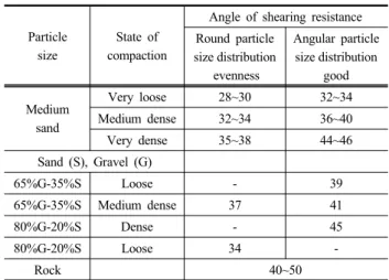
Table 4. Angle of shearing resistance according to particle shape and grain size distribution
Particle size
State of compaction
Angle of shearing resistance Round particle
size distribution evenness
Angular particle size distribution
good
Medium sand
Very loose 28~30 32~34
Medium dense 32~34 36~40
Very dense 35~38 44~46
Sand (S), Gravel (G)
65%G-35%S Loose - 39
65%G-35%S Medium dense 37 41
80%G-20%S Dense - 45
80%G-20%S Loose 34 -
Rock 40~50
Fig. 3. Relation between void ratio and dry density
Fig. 4. Relation between porosity and dry density
되었다. 실트질 모래가 많이 포함되어있는 지역은 다른 지역에 비해 높은 자연함수비와 투수계수로 인해 집중호우 시 토사재해에 취약할 수 있다. 직접전단시험과 흙의 실내투수 (변수위) 시험결과(Table 3)는 투수계수 1.03×10⁻³~8.18×10⁻⁵ cm/sec, 점착력 3.20~14.80kN/m2, 전단저항각 28.20~37.60°
를 나타났다.
2.1.3 토질정수 간의 상관관계
자연사면에서 간극의 상태, 밀도, 투수계수, 점착력, 내부 마찰각 등은 토층의 상태를 개략적으로 판단할 수 있는 요 소 중 하나이다. Braja(1998)의 연구 결과에 따르면, 토층의 투수성은 유체의 점성, 입도분포, 간극의 크기 및 비율, 광 물입자의 거칠기 및 토층의 포화도 등 여러 가지 요인에 영 향을 받으며 특히, 점성토에서의 입자의 구조는 투수계수와 밀접하게 관계된다. Holtz & Gibbs(1956)는 입자의 형상과 입도 분포에 따라 전단저항각의 변화를 등급으로 분류하여 제시하였다(Table 4). 투수계수는 간극 크기의 함수로서 흙 입자의 크기가 작을수록 물과 접촉하는 표면적은 커지게 되 고, 토층에서 물의 흐름에 대한 마찰저항이 증가되어 투수 계수를 감소시키게 되므로 투수계수는 입경에 비례한다(Lambe
& Whitman, 1969). 이와 같이 토사재해지역은 토질정수에
따라 발생 가능성 예측이 다를 수 있다는 것을 알 수 있다.
앞서 실시한 직접전단시험 결과(Table 3)를 활용하여 Holtz
& Gibbs(1956)의 연구(Table 4)에 적용한 결과 충주지역의 다 짐도는 매우 조밀, 대전과 안동지역은 중간 정도 조밀한 것으 로 사질지반에 해당하는 값이다. 이는 Table 1의 다짐도 시험 과 유사한 결과를 보이고 있다.
Fig. 3, Fig. 4는 간극과 건조밀도와의 관계를 도시한 것으
Fig. 5. Relation between coefficient of permeability and void ratio
Fig. 6. Relation between coefficient of permeability and porosity
Fig. 7. Relation between coefficient of permeability and effective size
Fig. 8. Relation between coefficient of permeability and coefficient of uniformity
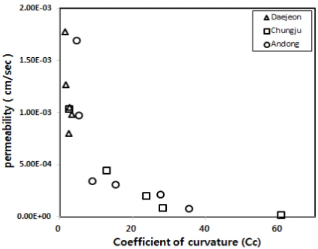
Fig. 9. Relation between coefficient of permeability and coefficient of curvature
로 화성암류 지역인 대전(SM) 및 안동(SM, ML)은 간극과 건조밀도의 추세가 반비례적인 관계가 나타났다. 변성암류 인 충주(ML)도 간극과 건조밀도의 추세가 반비례적으로 나 타났으며, 앞의 두 지역에 비해 분포 범위가 크게 나타났다.
Fig. 5는 투수계수와 간극비 간의 상관관계를, Fig. 6은 투 수계수와 간극률 간의 상관관계를, Fig. 7은 투수계수와 유효
입경 간의 상관관계를 도시한 것이다. 화성암류인 대전(SM) 및 안동(ML, SM)과 변성암류 지역인 충주(ML, SM) 간의 뚜렷한 상관성이 관찰되지는 않았으나, 토층의 분포가 실트 질 모래(SM)인 경우 간극비, 간극률, 유효입경이 커지면 투수 성이 양호해지는 비례적인 경향을 보이고, 저소성 실트(ML) 인 경우 상대적으로 간극비, 간극률이 클수록 유효입경이 작을수록 투수불량의 경향이 나타났다.
Fig. 8은 투수계수와 균등계수와의 상관관계를 Fig. 9는 곡률계수와의 상관관계를 도시한 것이다. 균등계수(Cu)는 입도분포곡선의 경사를 나타낸 것으로 흙이 함유한 입도 범 위가 작으면 작고, 입도 범위가 크면 크다. 통일분류법에서 는 균등계수는 “Cu > 6”, 곡률계수는 “1 < Cc < 3” 일 때 입도분포가 양호하다는 조건이다. 화성암류인 대전지역(SM) 은 Cu, Cc의 두 조건을 만족하여 입경분포가 양호하다. 안 동 및 충주지역(ML, SM)에서 SM 분포지역은 Cu, Cc의 두 조건을 만족하여 입경분포가 양호하며, ML 분포지역은 세 립토로 균등계수와 곡률계수를 적용할 수 없으나 상관관계
Table 5. Crown density based on crown distribution pattern
Form Crown
density Decision Form Crown
density Decision
0~10%
Very soarse (0-10%)
15%
Sparse (10-40%) 25%
35%
45%
Moderate (40-70%)
75%
Dense (70-100%)
55% 85%
65% 95%
Table 6. Calculation results of root cohesion
Species
Estimated root reinforcement
(kPa)
Revised value by the reduction
factor (=0.6) (kPa)
Revised value by the crown density (10%,
30%, 50%, 70%) (kPa)
Sawtooth oak
&
Koreanredpine
0.81 0.46
0.1 0.049 0.3 0.147 0.5 0.245 0.7 0.343
8.41 4.79
0.1 0.452 0.3 1.356 0.5 2.260 0.7 3.164
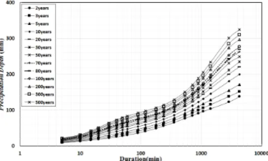
Fig. 10. Precipitation intensity by duration in Chungju
Fig. 11. Precipitation depth by duration in Chungju
확인을 위한 입경분포가 일부 또는 두 조건이 만족하지 않는 불량으로 나타났다.
2.2 수관밀도를 고려한 뿌리점착력
2.2.1 수관밀도(Crown density)
연구지역의 뿌리점착력을 적용하기 위하여 어떠한 임분 내에서 입목들의 수관이 그 임분을 덮고 있는 정도에 대하 여 조사하였다. 충주지역은 50m×50m, 대전, 안동지역은 30m×30m의 영역으로 나누어 범위 내에 대표 수목의 개체 밀도를 산정하여 수관밀도를 조사하였다. 뿌리점착력은 Wu (1976)가 연구한 역학적 변수를 이용하여 간접적으로 추정 하는 모형을 활용하여 적용하였다. 본 모형에서는 토양이 외부의 힘에 의해 전단파괴가 발생하면 지층 내부에 존재하 는 뿌리의 인장력으로 인해 전단강도가 증가된다. Wu et al.
(1979)이 연구한 Eq. (1)을 기반으로 Lee et al.(1991)의 연 구한 결과를 반영하여 상수 0.6을 적용한 수정 Eq. (3)을 분 석에 적용하였다. 수관밀도의 결정은 Korea Forest Research Institute(2011)를 참고하여 Table 5와 같이 나타냈다.
costan sin
(1)
(2)
× 수관밀도
(3)여기서, : 뿌리점착력
: 뿌리의 평균 인장강도(
)
: 뿌리단면적 비율(전체면적/단면적)
: 흙의 내부마찰각
: 전단 비틀림각(=tan
)
: 뿌리 변형거리
: 전단영역대전지역의 대표 수종은 상수리나무이며 안동 및 충주지 역은 중부지방 소나무이다. Kim et al.(2011)의 연구에 따르 면 본 연구지역의 경우는 0.81kPa~8.41kPa 범위의 뿌리점 착력이 적용된다는 것을 확인할 수 있으며, Eq. (3)을 적용 하여 수관밀도가 적용된 뿌리점착력 값(Table 6)을 분석에 적용하였다.
2.3 강우특성
일반적으로 토사재해는 강우강도 및 강우량과 밀접한 관 계를 가지며 우리나라는 기후변화의 영향으로 과거에 비해 강우일수는 줄었으나 토사재해가 발생할 수 있는 높은 강도 의 강우가 빈번해지는 경향을 보이고 있다. 강우강도가 흙
Fig. 12. Precipitation intensity by duration in Daejeon
Fig. 13. Precipitation depth by duration in Daejeon
Fig. 14. Precipitation intensity by duration in Andong
Fig. 15. Precipitation depth by duration in Andong
Table 7. Rainfall intensity of Huff 4th
Area Rainfall scenarios
Return period (year)
Rainfall duration (hr)
Rainfall intensity (mm/hr)
Chungju Huff 4th 30 24 11.7
Daejeon Huff 4th 30 24 11.5
Andong Huff 4th 30 24 10.5
의 투수계수의 5배를 넘게 되면 우수가 지중에 침투하기 시 작하여 침윤선(Wetting front)이 지층에 형성되기 시작한다.
이 상태가 계속되면 하부에서부터 지하수위가 상승하면서 동시에 간극수압이 증가되는 것으로 밝혀졌다(Hong, 1991).
따라서 보다 합리적인 토사재해 위험도 예측을 위해 이러한 지반특성을 파악하고 적용하였다.
충주지역은 Huff 4분위법을 활용하여 재현기간 30년, 지 속시간 24시간의 강우강도를 분석한 결과 11.7mm/hr로 나 타났다. 대전지역은 Huff 4분위법을 활용하여 재현기간 30 년, 지속시간 24시간의 강우강도를 분석한 결과 11.5mm/hr 로 나타났다. 안동지역은 Huff 4분위법을 활용하여 재현기 간 30년, 지속시간 24시간의 강우강도를 분석한 결과 10.5 mm/hr로 나타났다.
3. 토사재해 위험도 예측
3.1 해석프로그램
토사재해 위험지 예측을 위해 Iverson & Richard(2000)에 의해 제시된 방법을 사용하여 미국지질연구소(USGS)에서 개발된 TRIGRS(A Fortran Program for Rainfall Infiltration and Grid-Based Regional Slope-Stability Analysis)를 기반으 로 고도화하여 개발된 산지 토사재해 예측 프로그램(LSMAP, LansSlide MAPping)을 사용하였다. TRIGRS은 균질하고 등 방성인 매체에 대한 침투모델로 강우의 시간변화에 따른 요 소와 표층 비탈면 파괴 발생 가능성의 요소변화, 토양 내 압 력수두 및 지하수 변화를 적용할 수 있다. 비교・분석을 위 하여 SINMAP(Stability Index MAPping)과 산림청의 Landslide Hazard Map(Korea Forest Service) 결과를 활용하였다.
3.2 수관밀도 분석
2.2항에서 서술한 바와 같이 대전지역의 대표 수종은 상 수리나무이며 안동 및 충주지역은 중부지방 소나무이다(Korea forest service, 2016). 연구지역을 충주 50m*50m, 대전 및 안동지역은 30m*30m의 영역으로 나누어 조사한 결과를 Fig.
16~18에 나타내었다. Fig. 16~18은 각 연구 지역의 산림 입지분포(a), 수관밀도 조사 위치(b), 수관밀도(c)로 나타내 었다. 연구지역의 수관밀도는 전체적으로 0~70%의 범위 에 있으며 (c)와 같이 10%, 30%, 50%, 70% 지역으로 구분 하였다.
(a) Distribution of trees
(b) Survey location (c) Crown density survey results Fig. 16. Distribution of trees and crown density in Chungju
(a) Distribution of trees
(b) Survey location (c) Crown density survey results Fig. 17. Distribution of trees and crown density in Daejeon
(a) Distribution of trees
(b) Survey location (c) Crown density survey results Fig. 18. Distribution of trees and crown density in Andong
3.3 위험도 예측 결과
앞 절에서 제시한 지반특성을 이용하여 토사재해 위험도 예측을 실시하였다. 연구 지역의 예측 모델별 토사재해 위험 지 분포도를 비교하기 위하여 SINMAP과 LHMAP을 LSMAP 과 비교하였다. 그 결과는 Fig. 19~21, Table 8~10과 같다.
충주지역의 토사재해 위험지 예측결과는 분포면적 대비 SINMAP 15%, LHMAP 1% 미만, LSMAP 2.7%를 위험지 역으로 예측하였고, 대전지역은 SINMAP 2.9%, LHMAP 1%
미만, LSMAP 2.3%, 안동지역은 SINMAP 8.3%, LHMAP 1% 미만, LSMAP 4.1%를 위험지역으로 예측하였다. Table 8~10과 같이 LHMAP는 미소, SINMAP의 과다, LSMAP 은 두 모델의 중간 정도 범위의 지역을 위험지역으로 예측 하였다.
이러한 예측 결과의 차이는 모델별 특성에 따른 것으로 이 러한 특성은 분석 매개변수에 따라 달라진다. 다음 Table 11 은 각 모델에 적용되는 분석 매개변수를 나타내었다. LSMAP 이 SINMAP 및 LHMAP 보다 분석 매개변수가 비교적 다 양하고, 공학적인 것으로 판단된다.
(a) Dangerous areas (LSMAP)
(b) Dangerous areas (SINMAP)
(c) Dangerous areas (LHMAP)
Fig. 19. Prediction of landslide hazard in Chungju
Table 8. Distribution area and dangerous zone
Area SINMAP
LHMAP LSMAP
Defended Upper theshold
Chungju 1.1% 13.9% 0.3% 2.7%
(a) Dangerous areas (LSMAP)
(b) Dangerous areas (SINMAP)
(c) Dangerous areas (LHMAP)
Fig. 20. Prediction of landslide hazard in Daejeon
Table 9. Distribution area and dangerous zone
Area SINMAP
LHMAP LSMAP
Defended Upper theshold
Daejeon 0.2% 2.7% 0.3% 2.3%
(a) Dangerous areas (LSMAP)
(b) Dangerous areas (SINMAP)
(c) Dangerous areas (LHMAP)
Fig. 21. Prediction of landslide hazard in Andong
Table 10. Distribution area and dangerous zone
Area SINMAP
LHMAP LSMAP
Defended Upper theshold
Andong 3.1% 5.2% 0.1% 4.1%
Table 11. Analysis parameter comparison
ModelClassification LSMAP SINMAP LHMAP
Elevation ● ●
Slope ● ● ●
Flow direction ● ●
Soil depth ● ● ●
Soil cohesion ● ●
Root cohesion ●
Soil weight ● ●
Tree weight ●
Forest physiognomy ● ●
Crown density ●
Internal friction angle ● ●
Water table ●
Hydraulic diffusivity ●
Conductivity ● ●
Rainfall intensity ● Infiltration rate ●
Cultivation volume ●
Slope length ●
Slope position ●
Slope forms ●
4. 결 론
본 연구는 변성암류인 충주지역, 화성암류인 대전지역 및 안동지역의 지반 및 토질특성, 강우특성, 수관밀도를 적 용한 뿌리점착력을 매개변수로 산정하여 토사재해 위험지 역을 예측・연구하였다.
(1) 위험지역에 대한 토사재해 예측을 위해서는 수관밀도 에 따른 뿌리점착력을 고려함으로써 보다 정밀한 예측 이 가능하다는 것을 알 수 있었다.
(2) 연구지역 토사재해 위험도 예측결과 일반적으로 사용되 고 있는 SINMAP의 경우 과다한 범위를 위험지역으로 예측하였다. 산림청 산사태위험지도(LHMAP)의 경우 예 측지역이 가장 적게 산정되었으며, LSMAP은 SINMAP, LHMAP에서 예측된 지역을 중심으로 범위를 축소하여 보다 정밀하게 위험지역으로 예측하였다.
(3) 각각의 프로그램 특성에 따라 예측범위가 다양하게 산 정되며, 이러한 특성은 입력 자료에 따라 매우 다른 결 과를 도출하는 것으로 분석되었다.
(4) 추후 여러 지역에 대한 지반특성 자료를 이용하여 토사 재해에 영향을 주는 다양한 요소를 고려하여 연구한다 면 지역 특성을 고려한 합리적인 위험도 예측이 가능할 것으로 판단된다.
감사의 글
This research was supported by Development of the Integrated Management System for the Mud and Debris Flow Prediction and Assessment with Consider action of Urban Characteristics (14SCIP-B069989-02) from Korea Agency for Infrastructure Technology Advancement (KAIA).
References