Acoustic Characteristics of Gas-related Structures in the Upper Sedimentary Layer of the Ulleung Basin, East Sea
11
0
0
전체 글
(2) 514. 박현탁·유동근·한혁수·이정민·박수철. 련 구조들의 분포양상은 상부퇴적층의 퇴적상과 수심에 따른 가스의 용해도 차이에 의해 조절된 것으로 사료된다. 특 히, 울릉분지 사면지역의 쇄설류 퇴적체는 무질서하고 불연속적인 퇴적구조를 보이며, 이는 가스의 이동을 용이하게 한다. 반면, 분지의 저탁류 퇴적체는 수평층리가 잘 발달되어 있어, 가스의 수직이동을 제한하는 것으로 해석된다. 주요어 : 울릉분지, 가스관련 구조, 첩 탄성파 자료, 음향특성. 1. 서. 론. 해양에 존재하는 천부가스는 주로 해저면 아래 약 1,000 m 이내의 퇴적층에 분포하고 있으며, 대륙붕부 터 심해저까지 넓은 지역에서 확인되고 있다(Davis, 1992; Fleischer et al., 2001; Hovland and Judd, 1988; Lee and Chough, 2003). 천연가스의 주성분인 메탄은 연소 시 이산화탄소의 배출량이 적어 청정에너 지 자원으로써 활용가치가 매우 높으며, 저온고압의 환 경에서 가스하이드레이트가 형성되는데 필수적인 성분 이다. 뿐만 아니라, 심해환경에서의 가스 유출은 화학 합성 생태계를 형성하는데 매우 중요한 역할을 한다. 하지만, 가스방출은 해저면의 안정성에 영향을 미쳐 해 저구조물 침하현상이나 해저 사태를 유발하여 인간 활 동에 위해요인으로 작용할 수 있다. 또한, 대표적 온실 가스인 메탄이 대기로 유입되면 지구온난화를 가속화 시킬 수 있으므로 천부가스의 거동을 파악하고, 해양 과 대기로의 유입과정을 이해하는 것은 중요한 의미를 가진다(Gay et al., 2007; Huh et al., 1999; Lee et al., 2003). 국내 및 국외에서는 천부가스의 분포 및 이동양상을 밝히기 위해 지구물리탐사를 이용한 다양한 연구가 수 행되어 왔다. Judd and Hovland (1992; 2007)는 고 해상도 탄성파 자료를 이용하여 음향혼탁층, 증폭반사 면, 칼럼(침니)구조, 돔구조, 폭마크 등 다양한 가스관 련 지시자를 확인하고, 이들의 특성 및 형성기작에 대 해 언급하였다. Gay et al. (2007)은 콩고분지에서 멀 티빔 후방산란 이미지(multibeam backscatter image) 와 3D 탄성파자료를 이용하여 가스관련 구조들의 분 포양상을 파악하고 가스관련 유체들의 흐름을 조절하 는 지질학적 요인들을 밝히는 연구를 시행하였다. Dondurur et al. (2011)은 터어키의 이즈미르 만에서 첩(chirp) 탄성파 자료와 사이드 스캔 소나(side scan sonar) 자료를 이용하여 가스관련 구조들의 특징과 분 포에 대해 확인하고 가스유출모델을 제시하였다. Kim et al. (2004)과 Lee et al. (2005)은 대한해협 이토대 (Korea Strait Shelf Mud, KSSM)에서 고해상도 탄성 파 자료를 이용하여 다양한 가스관련 음향이상구조들. 의 분포특성에 대해 연구하였다. 또한, Kim et al. (2008a)은 진해만에서 탄성파 자료를 이용하여 가스관 련 음향이상구조를 분류하고 이들의 특징에 대해 파악 하였다. Lee and Chough (2003)는 고해상도 탄성파 자료를 이용하여 울릉분지에서 천부가스의 분포지역을 확인하였으며, Choi et al. (2001)과 Yoo et al. (2008) 은 해저모방반사면(Bottom Simulating Reflector, BSR), 칼럼구조, 가스분출, 음향공백대, 증폭반사면등 가스 또 는 가스하이드레이트의 부존을 지시하는 탄성파 특성 에 대해 밝혔다. 하지만, 가스가 이동하는데 퇴적환경 이 중요한 역할을 함에도 불구하고, 천부퇴적환경과 연 계한 지질학적 해석은 미흡한 실정이다. 따라서, 본 연구에서는 고해상도 탄성파 자료의 탄 성파상 분석을 통하여 울릉분지의 가스관련 구조들을 분류하고, 이들의 분포양상을 파악함으로써 천부가스 관련구조들의 생성과정과 퇴적환경에 따른 분포특성에 대해 고찰해보고자 한다.. 2. 연구지역 동해는 환태평양 화산 및 지진대의 뒤쪽에 형성된 후열도분지(back-arc basin)이며, 한국, 일본 그리고 러 시아로 둘러싸여 있다. 또한, 동해에는 세 개의 주요 분지인 일본분지(Japan Basin), 야마토분지(Yamato Basin) 그리고 울릉분지(Ulleung Basin)가 존재하며, 이들 분지는 한국대지(Korea Plateau), 오키뱅크(Oki Bank) 그리고 대화퇴(Yamato Rise)에 의해 구분된다 (Bahk et al., 2000; Han et al., 1997; Park et al., 2005)(Fig. 1). 연구지역인 울릉분지는 동해의 남서쪽에 위치하고, 서쪽은 한반도의 대륙사면과 접하며, 북쪽으로는 한국 대지, 동쪽과 남쪽은 각각 오키뱅크와 일본열도에 의 해 둘러싸여 있다(Fig. 1). 또한, 울릉분지는 움푹 파인 지형적 특징을 보이며, 최대수심은 약 2,200 m에 달한 다. 분지의 서쪽사면은 10o 이상의 가파른 경사를 보 이며, 대규모의 사면붕괴 및 사태에 의한 지형들이 발 달하고 있다. 비교적 완만한 경사(<3o)를 보이는 남쪽 과 동쪽사면은 다양한 규모의 사면붕괴 지형들이 발달.
(3) 동해 울릉분지 퇴적층 상부에 존재하는 가스관련 퇴적구조의 음향 특성연구. 515. Fig. 1. Batymetry map (unit in meters) of the Ulleung Basin and track-lines of high-resolution chirp profiles. Thick lines with numbers indicate seismic sections shown in Figs. 2-5.. 하고 있으며, 소규모의 침식지형(gully)들이 대륙붕단부 터 수심 1,000 m까지 연장되어있다(Chough et al., 2000; Kang et al., 2009). 울릉분지의 천부퇴적층은 다양한 질량류 퇴적체들이 중첩되어 나타난다. 대륙사면의 상부에는 함몰사태와 미끄럼사태 퇴적체들이 분포하며, 중부와 하부사면에는 쇄설류 퇴적체(debris flow deposits)가 나타난다. 또한, 분지평원에는 주로 저탁류 퇴적체(turbidites)와 반원양 성 퇴적체(hemipelagites)가 우세하게 분포한다(Chough et al., 1997; Lee et al., 1999; Yoon et al., 2003).. 3. 재료 및 방법 본 연구에서는 동해 울릉분지에서 취득된 고해상도 탄성파 자료를 활용하였다. 이 자료는 충남대학교와 국 립해양조사원에서 1994년부터 1996년 사이에 첩 소나. 시스템(Chirp sonar system, CAP-6000W)으로 취득되 었다(Fig. 1). 일반적으로 탄성파 탐사자료는 퇴적층간의 음향임피 던스 차이로 발생하는 다양한 반사특성을 보여준다. 특 히, 가스가 포함된 퇴적층에서는 탄성파 에너지가 흡 수 또는 산란되어 다양한 음향이상구조가 나타난다. 첩 소나 시스템은 비교적 고주파수를 사용하는 장비로 투 과심도는 낮지만 해상도가 뛰어나 천부퇴적층에서 가 스부존과 연계하여 나타나는 다양한 형태의 음향특징 을 분석하는데 유용하다. 첩 소나 시스템의 일종인 CAP-6000W는 2-7 kHz 주파수대역의 음원을 가지며, 일정시간 동안 주파수를 연속적으로 변화시켜주는 스 윕신호(sweep signal)를 사용하여 6-20 cm의 분해력 과 수십 m의 투과력을 보인다. 첩 소나 시스템으로 획득한 자료는 엑사바이트(Exa-byte) 데이터 카트리지 에 SEG-Y 포맷으로 저장되었으며, 항측자료는 위성항.
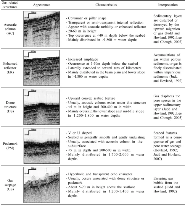
(4) 516. 박현탁·유동근·한혁수·이정민·박수철. 법정보시스템(Differential Global Positioning System, DGPS)인 Trimble사의 4000RS/DS system을 이용하 여 취득하였다. 본 연구에서는 가스관련 구조들을 분류하고 특징을 파악하기 위해 반사파의 강도, 연속성, 외부형태, 지형 특징 등의 탄성파상 분석을 실시하였다. 또한, 가스관 련 구조들의 공간적인 분포양상을 알아보기 위해 분포. 도를 작성하였다.. 4. 연구결과 4.1. 울릉분지에서 나타나는 가스관련 구조의 분류 및 특징 연구지역의 고해상도 탄성파 자료에 나타나는 가스. Table 1. Classification and characteristics of gas-related structures in the Ulleung Basin Gas related structures. Appearance. Characteristics. Interpretation. Acoustic column (AC). - Columnar or pillar shape - Transparent or semi-transparent internal reflection - Appear with acoustic turbidity or enhanced reflector - 20-60 m in height - Top occurrence at <40 m depth below the seabed - Mainly distributed in >1,800 m water depths. Sedimentary layers are disturbed or destroyed by the upward migration of gas (Judd and Hovland, 1992; Lee and Chough, 2003). Enhanced reflector (ER). - Increased amplitude - Occurrence at 5-50m depth below the seabed - Laterally extended to several tens of kilometers - Mainly distributed in the basin plain and lower slope in >1,800 m water depths. Accumulations of gas within porous sediments, or gas is finely disseminated within impervious sediments (Judd and Hovland, 1992). Dome structure (DS). - Upward convex seabed feature - Usually, acoustic column exists under this structure - <5 m in height and 200-400 m in width - Mainly occurs in the lower slope and middle slope in 1,200-1,800 m water depths. Gas displaces the pore spaces in the upper sedimentary layer (Judd and Hovland, 1992; Lee and Chough, 2003). Pockmark (PM). - V or U shaped - Seabed is generally smooth and gently undulating - Usually, associated with acoustic column in the subsurface - <5 m in depth and 200-500 m in width - Mainly distributed in 1,700-2,000 m water depths. Seabed features formed as a conse quence of gas and pore water seepage (Hovland, 1992; Judd and Hovland, 2007). Gas seepage (GS). - Hyperbolic and transparent echo character - Usually, occurs associated with dome structure or pockmark - About 5-20 m in height above the seafloor - Mainly distributed in 1,200-1,400 m water depths. Escaping gas bubble from the seabed (Judd and Hovland, 1992).
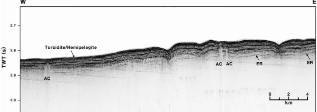
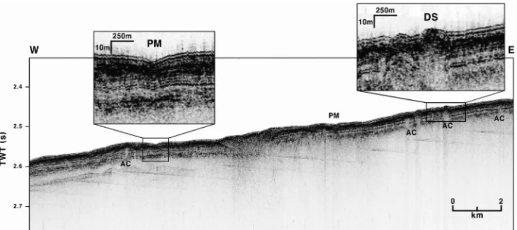
(5) 동해 울릉분지 퇴적층 상부에 존재하는 가스관련 퇴적구조의 음향 특성연구. 관련 구조들은 음향공백기둥(acoustic column, AC), 증폭반사면(enhanced reflector, ER), 돔구조(dome structure, DS), 폭마크(pockmark, PM), 가스유출구조 (gas seepage, GS)등으로 분류된다(Table 1). 음향공백기둥은 퇴적층을 수직으로 가로지르는 기둥 형태로 내부층리가 나타나지 않는 투명(transparent) 또는 반투명한(semi-transparent) 음향특성을 보인다 (Table 1). 연구지역에서 확인된 음향공백기둥은 폭이 수십 m부터 최대 500 m 이상까지 다양한 규모를 보 이며, 이 구조의 상부경계면은 해저면으로부터 0-40 m 하부에서 나타난다. 또한, 음향공백기둥은 해저면 반사 파가 뚜렷하고 하부의 수평층리가 연속적으로 잘 발달된 저탁류/반원양성 퇴적체에서 우세하게 확인된다(Fig. 2). 증폭반사면은 주변 반사면에 비해 매우 강한 진폭특 성을 보인다(Table 1). 이들은 층리를 따라 수평적으로 수십 km 이상 길게 연장되어 나타나며, 해저면 하부. 517. 5-50 m 깊이에서 확인된다(Fig. 2). 돔구조는 해저면이 둔덕형태로 부풀어 오른 지형특 징을 보이며, 하부반사파는 대체적으로 분산되어 (prolonged) 나타난다(Table 1). 본 연구에서 확인된 돔구조는 200-400 m의 폭과 5 m 이하의 높이를 보 이며, 이 구조의 하부에는 일반적으로 음향공백기둥이 나타난다. 이러한 돔구조는 해저면 반사파가 비교적 뚜 렷하고 내부음향상이 투명한 로브(lobe)형태의 쇄설류 퇴적체에서 주로 나타난다(Fig. 3). 폭마크는 일반적으로 분화구와 같이 해저면이 움푹 파 인 지형특징과 불연속적이며 혼탁한 하부반사특성을 보 인다(Table 1). 연구지역에서 이들의 너비는 200-500 m, 깊이는 5 m 이하로 확인되며, 각각의 종횡비(depth/ width aspect ratio)는 0.01-0.015로 나타난다. 이러한 구조들은 저탁류와 쇄설류 퇴적체가 혼재하는 지역에 서 다양한 가스관련 구조들과 함께 나타난다(Fig. 4).. Fig. 2. High-resolution chirp profile showing acoustic column (AC) and enhanced reflector (ER) in the basin plain of the Ulleung Basin. The basin plain is mainly covered by turbidite/hemipelagite complexes. Vertical axis is two-way travel time in seconds (s) and 0.1s corresponds to approximately 75 m of sediment. For location of profile, see Fig. 1.. Fig. 3. High-resolution chirp profile showing dome structure (DS) and acoustic column (AC) in the lower slope of the eastern Ulleung Basin. Dome structure at the seafloor mainly occurs in the region of the debris-flow deposits and is usually accompanied by acoustic column in the sedimentary layer below the seafloor. Vertical axis is two-way travel time in seconds (s) and 0.1s corresponds to approximately 75 m of sediment. For location of profile, see Fig. 1..
(6) 518. 박현탁·유동근·한혁수·이정민·박수철. Fig. 4. High-resolution chirp profile showing acoustic column (AC), pockmark (PM), and dome structure (DS) in the lower slope of the Ulleung Basin. Vertical axis is two-way travel time in seconds (s) and 0.1s corresponds to approximately 75 m of sediment. For location of profile, see Fig. 1.. Fig. 5. High-resolution chirp profile showing gas seepage (GS) in the middle slope of the eastern Ulleung Basin (a) and in the middle slope of the southern Ulleung Basin (b). Gas seepage mainly occurs in the region of the debris-flow deposits. Vertical axis is two-way travel time in seconds (s) and 0.1s corresponds to approximately 75 m of sediment. For location of profile, see Fig. 1..
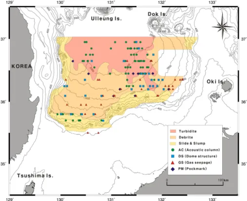
(7) 동해 울릉분지 퇴적층 상부에 존재하는 가스관련 퇴적구조의 음향 특성연구. 가스유출구조는 수층에서 주변 퇴적층에 비해 매우 약한 반사강도를 보이며, 해저면으로부터 약 5-20 m의 높이까지 나타난다(Table 1). 이러한 가스유출구조는 불 연속적인 해저면 반사파와 무질서한 내부음향 특성을 보이는 쇄설류 퇴적체에서 주로 확인된다(Fig. 5). 4.2. 울릉분지 천부가스관련 구조의 분포양상 울릉분지의 상부사면은 가파른 경사를 보이며, 다양 한 규모의 함몰사태와 미끄럼사태 퇴적체들로 이루어 져있다(Fig. 6). 이에 비해 중부와 하부사면에는 주로 쇄설류 퇴적체가 분포하며, 이들은 고해상도 탄성파 단 면상에서 크게 두 개의 음향특성으로 구분된다. 그 중, 중부사면의 쇄설류 퇴적체는 무질서한 내부음향 특성 을 보인다. 이에 비해 하부사면에는 비교적 뚜렷한 해 저면 반사파와 투명 또는 반투명한 내부음향 특성을 보이는 로브형태의 쇄설류 퇴적체가 분포한다. 또한, 사면의 기저부는 쇄설류에서 저탁류 퇴적체로 전이되 는 특징을 보이며, 분지평원은 주로 수평층리가 발달 한 저탁류/반원양성 퇴적체가 분포한다(Fig. 7). 본 연. 519. 구에서 확인된 가스관련 구조들은 울릉분지의 전반에 걸쳐 나타나지만, 지역/수심별 그리고 퇴적상에 따라 분포양상의 차이를 보인다(Figs. 6 and 7). 연구지역에서 가장 많이 확인된 음향공백기둥은 울 릉분지의 남서쪽 상부사면과 분지평원에서 집중되어 분 포한다. 특히 분지평원의 서쪽에서는 약 2,000 m 이상 의 수심에서 나타나며, 이에 비해 동쪽에서는 1,500 m 의 비교적 낮은 수심대까지 분포한다. 이러한 음향공 백기둥의 분포양상은 비교적 해저면 반사파가 뚜렷하 고 수평층리의 연속성이 좋은 저탁류 또는 반원양성 퇴적체의 분포양상과 매우 유사한 특징을 보인다. 돔구조는 하부사면과 사면의 기저부에서 주로 분포 하며, 로브형태의 쇄설류 퇴적체로 이루어진 지역에서 우세하게 나타난다. 또한, 돔구조는 분지의 남서쪽사면 에서 1,200-1,800 m의 수심대에 넓게 산재되어 분포 하는 반면, 남동쪽사면에서는 수심 1,600-1,800 m에 집중되어 나타난다. 폭마크는 수심 1,000-2,000 m의 중부 및 하부사면 에서 제한적으로 나타난다. 가스유출구조는 분지의 중. Fig. 6. Gas-related structures in the Ulleung Basin, superimposed on the distribution map of mass-flow deposits (Chough et al., 1997). Acoustic columns are observed mainly in the basin floor or base of slope, while pockmarks, dome structures and gas seepages occur in the lower slope and middle slope, respectively..
(8) 520. 박현탁·유동근·한혁수·이정민·박수철. Fig. 7. Schematic diagram showing the zonal distribution of sedimentary facies with water depth and occurrence of gasrelated seabed structures.. 부사면에서 주로 분포하며, 분지평원에서는 거의 나타 나지 않는다. 특히, 이 구조는 무질서한 반사특성을 보 이는 쇄설류 퇴적체 지역에서 다수 확인된다. 또한, 가 스유출구조는 분지의 남서쪽 사면에서 수심 1,2001,900 m의 비교적 넓은 지역에 분산되어 나타나는 반 면, 분지의 남동쪽 사면에서는 1,000-1,200 m의 수심 대에서 조밀하게 분포한다.. 5. 토. 의. 5.1. 울릉분지 천부가스관련 구조들의 형성과정 Fig. 8은 울릉분지에서 확인된 가스관련 구조들의 발 달과정을 보여주고 있다. 일반적으로 가스는 유기물이 생물 또는 열분해 작용을 받아 분해될 때 생성되며, 울릉분지에서 확인된 천부가스는 주로 생물분해 작용 에 의해 형성된 것으로 연구되어진 바 있다(Kim et al., 2008b; Park et al., 2006). 이렇게 생성된 천부가 스는 퇴적층의 공극사이에 분산되어 존재하며, 음향혼탁 층(acoustic turbidity layer) 또는 음향공백대(acoustic blanking zone)와 같은 음향이상구조로 나타난다 (Davis, 1992; Floodgate and Judd, 1992; Naudts et al., 2009)(Fig. 8a). 또한, 퇴적층 내에서 가스의 양 (부피)이 증가하면 주변 퇴적층의 밀도가 감소하고, 강 한 부력이 발생하여 가스의 이동이 발생하게 된다. 이 와 같이 퇴적층에서 이동하던 가스관련 유체가 불투수. 성 퇴적층에 의해 수직적인 이동이 제한되고 수평 이 동하여 축적되면 증폭반사면과 같은 구조가 형성된다 (Iglesias and Garcia-Gil, 2007; Judd and Hovland, 1992)(Fig. 8b). 이와 달리, 유체가 퇴적층의 약한 부분 을 뚫거나 균열을 따라 해저면 쪽으로 상향이동 할 경우 에는 음향공백기둥이 생성된다(Judd and Hovland, 1992; Lee and Chough, 2003; Schroot and Schüttenhelm, 2003)(Fig. 8c). 또한, 해저면까지 이동한 가스들이 곧바 로 방출되기도 하지만, 상부 퇴적층에 의해 방출되지 못하고 퇴적체의 공극을 채우게 되면 돔형태의 지형이 생성된다(Judd and Hovland, 1992; 2007; Lee and Chough, 2003)(Fig. 8d). 이러한 돔구조는 가스에 의해 생성되는 해저면 구조 중 가장 초기단계인 것으로 보고 된 바 있다(Casas et al., 2003; Judd and Hovland, 2007). 해저면에 포집되어있던 가스는 퇴적층의 균열을 통해 수층으로 새어 나오거나, 퇴적층 내에서 가스에 의해 과잉공극압이 발생하면 순간적으로 방출하게 된 다(Judd and Hovland, 1992; 2007)(Fig. 8e). 이때, 가스 뿐 만아니라 퇴적물도 함께 빠져나가 움푹 파인 지형인 폭마크가 형성되며, 이는 가스관련 해저면 구 조 중 가장 마지막에 생성되는 것으로 보고되고 있다 (Hovland, 1992; Judd and Hovland, 2007)(Fig. 8f). 이러한 폭마크는 퇴적물의 입자크기나 퇴적구조에 따 라 다양한 규모를 보이며, 퇴적물의 입자가 세립 할수 록 더 큰 규모로 발달하는 것으로 알려진 바 있다.
(9) 동해 울릉분지 퇴적층 상부에 존재하는 가스관련 퇴적구조의 음향 특성연구. 521. 연구지역에서 확인된 가스관련 구조들은 분지의 서 쪽사면에 비해 주로 분지의 동쪽과 남쪽사면에 집중적 으로 분포한다. 이는 울릉분지의 남쪽 대륙사면에서 저 해수면시기에 사면 사태가 빈번하게 발생하였으며(Bahk et al., 2000; Chough, 1984; Chun et al., 1997), 이때 공급된 다량의 퇴적물이 천부가스의 생성에 영향 을 미친 것으로 사료된다. 즉 해수면이 하강한 저해수 면 조건하에서는 대륙붕단 및 상부사면을 중심으로 퇴 적물 공급이 증가하였으며, 중력에 의해 퇴적물이 하 부사면과 분지평원으로 유입되었다. 이때 남쪽과 동쪽 사면에는 두꺼운 질량류 퇴적체가 형성되었으며, 이는 생물기원 가스의 생성을 증가시키는 요인으로 작용하 였을 것이다. 이에 비해 서쪽사면은 상대적으로 퇴적 물의 공급원이 제한적이며, 가파른 경사로 인해 퇴적. Fig. 8. Schematic diagram illustrating formation of gasrelated structures. Shallow gas in the sediments usually appears as the acoustic turbidity (a). Gas migrates horizontally or vertically along the crack, thus forming enhanced reflector (b) or acoustic column (c), respectively. Dome structure is built by gas pressure in the shallow porous sediments below an impermeable sealing layer (d). Gas bubble escapes from the seabed (e), and pockmark is produced as a result of gas escapes (f).. (Judd and Hovland, 2007; Uchupi et al., 1996). 또 한, 기존 연구들에서 폭마크는 일반적으로 10-300 m의 너비와 0.01-0.2의 종횡비로 확인 되었다(Hovland and Judd, 1988; Stewart, 1999). 본 연구에서 확인된 폭 마크의 경우 기존 연구에 비해 너비는 비교적 큰 규모 를 보이지만, 각각의 종횡비는 유사하게 나타난다. 5.2. 울릉분지 가스관련 구조들의 분포에 영향을 주 는 요인 일반적으로 가스와 관련된 유체의 이동은 가스의 부 력, 공극압, 퇴적물의 밀도, 점성도, 투수율, 퇴적률, 단 층이나 균열등 다양한 요인에 의해 영향을 받는 것으 로 보고되고 있다(Davis, 1992; Floodgate and Judd, 1992; Judd and Hovland, 2007; Lee and Chough, 2003).. 물이 축적되지 못한 것으로 사료된다. 또한, 연구지역에 분포하는 가스관련 구조들의 분포 특징 분석에 의하면 분지평원에는 상부퇴적층의 내부 에 발달하는 음향공백기둥과 증폭반사면이 주로 분포 하는 반면, 사면지역에서는 해저면에서 확인되는 돔구 조, 폭마크 그리고 가스유출구조가 우세하게 나타난다 (Figs. 6 and 7). 이러한 분포양상은 수심에 따른 가스 용해도와 상부퇴적층의 퇴적상 등의 영향을 받은 것으 로 사료된다. Lee et al. (2005)은 가스용해도가 퇴적 층 내에 존재하는 자유 가스의 부피를 조절하여 가스 방출에 영향을 미친다고 보고하였다. 가스용해도가 낮 은 지역에서는 높은 지역에 비해 상대적으로 퇴적층 내에 자유 가스의 양이 증가하게 된다. 이 결과 퇴적 층 내에서 자유 가스에 의해 상대적으로 높은 공극압 과 강한 부력이 발생하게 된다. 일반적으로, 가스의 용 해도는 온도에 반비례하고, 압력에 비례한다. 울릉분지 는 수심 1,000 m 이상에서 약 0.2oC 내외의 균일한 수온분포를 보인다(Kim et al., 2005). 이에 비해, 울 릉분지의 사면지역과 분지평원은 약 600-800 m (6080 atm)의 수심(압력)차를 보이며, 따라서 사면지역에 서는 상대적으로 낮은 용해도가 나타난다. 또한, 사면 지역의 쇄설류 퇴적체는 불연속적인 퇴적구조를 보이 며, 이는 가스의 이동을 용이하게 한다. 뿐만 아니라, 사면지역의 가파른 경사는 사면안정성에 영향을 미쳐 퇴적물의 이동을 유발시킨다. 이러한 퇴적물의 흐름은 해저면을 침식 또는 교란시켜 하부퇴적층에 존재하던 가스의 방출을 촉진시킨 것으로 사료된다. 반면, 분지 평원은 2,000 m 이상의 수심을 보이며, 이로 인해 상 대적으로 용해도가 높게 나타난다. 또한, 분지평원의 저탁류/반원양성 퇴적체는 수평층리가 잘 발달되어 있.
(10) 522. 박현탁·유동근·한혁수·이정민·박수철. 으며, 이러한 퇴적구조는 유체의 수직이동을 방해하고 수평이동을 보다 용이하게 한다. 이 지역에서 주로 확 인된 증폭반사면은 이러한 가스의 수평이동을 반증한 다. 또한, 경사가 완만한 분지평원은 사면지역에 비해 안정된 환경이 유지되며, 교란되지 않은 상부퇴적층에 의해 가스의 방출이 제한된 것으로 사료된다.. 6. 결. 론. 본 연구는 울릉분지에 존재하는 가스관련 구조들(음 향공백기둥, 증폭반사면, 돔구조, 폭마크, 가스유출구조) 의 특징, 생성과정 그리고 분포특성을 규명하였다. 연 구지역에서 확인된 가스관련 구조들은 다양한 음향특 성과 규모를 보이며, 퇴적층 내에서 유기물의 분해로 생성된 가스가 해저면으로 이동하고 방출되는 일련의 과정 중에 형성된다. 상부퇴적층 내에서 나타나는 음향공백기둥과 증폭반 사면은 저탁류/반원양성 퇴적체로 이루어진 분지평원 에서 주로 분포한다. 반면, 해저면에서 나타나는 돔구 조, 폭마크, 가스유출구조는 쇄설류 퇴적체로 구성된 중부와 하부사면에서 주로 확인된다. 이러한 분포양상 은 상부퇴적층의 퇴적상과 수심에 따른 용해도 차이에 의해 조절된 것으로 사료된다. 울릉분지의 사면지역에 서는 무질서하고 불연속적인 퇴적구조를 보이는 쇄설 류 퇴적체에 의해 가스의 이동이 용이한 반면, 분지평 원에서는 수평층리가 잘 발달한 저탁류 퇴적체가 가스 의 수직이동을 방해한 것으로 사료된다. 또한, 사면지 역은 분지평원에 비해 가스용해도가 낮으며, 이러한 환 경은 가스가 이동하는데 유리한 조건을 제시한 것으로 사료된다.. 사. 사. 본 연구는 한국지질자원연구원에서 수행중인 “가스 하이드레이트 지구물리탐사 연구’’ 위탁과제의 일환으 로 실시되었다. 첩 탄성파 자료를 이용하도록 도와주 신 국립해양조사원에 감사드립니다. 바쁘신 와중에도 세세히 검토해주신 서영교 박사님과 이광수 박사님께 진심으로 감사드립니다.. 참고문헌 Bahk, J.J., Chough, S.K. and Han, S.J. (2000) Origins and paleoceanographic significance of laminated muds. from the Ulleung Basin, East Sea (Sea of Japan). Mar. Geol., v.162, p.459-477. Casas, D., Ercilla, G. and Baraza, J. (2003) Acoustic evidences of gas in the continental slope sediments of the Gulf of Cadiz (E Atlantic). Geo-Mar. Lett., v.23, p.300-310. Choi, D.R., Hong, J.K., Yoo, H.S., Jou, H.T. and Han, S.J. (2001) Gas hydrate occurrence in the Southwestern Slope of the Ulleung Basin, East Sea, Inferred from seismic evidence. J. Oceanogr. Soc. Korea, v.6, p.242248. Chough, S.K. Lee, H.J. and Yoon, S.H. (2000) Marine Geology of Korean Seas. Elsevier, Amsterdam, 307p. Chough, S.K. (1984) Fine-grained turbidites and associated mass flow deposits in the Ulleung (Tsushima) Basin, East Sea (Sea of Japan). Geol. Soc. London, p.185-196. Chough, S.K., Lee, S.H., Kim, J.W., Park, S.C., Yoo, D.G., Han, H.S., Yoon, S.H., Oh, S.B., Kim, Y.B. and Back, G.G. (1997) Chirp (2-7 kHz) echo characters in the Ulleung Basin. Geosci. Jour., v.1, p.143-153. Chun, J.H., Han, S.J. and Cheong, D.K. (1997) Tephrostratigraphy in the Ulleung Basin, East Sea: late Pleistocene to Holocene. Geosci. Jour., v.1, p.154-166. Davis, A.M., (1992) Shallow gas: an overview. Cont. Shelf Res., v.12, p.1077-1079. Dondurur, D., Cifci, G., Drahor, M. G. and Coskun, S. (2011) Acoustic evidence of shallow gas accumulations and active pockmarks in the Izmir Gulf, Aegean sea. Mar. petro. geol., v.28, p.1505-1516. Fleischer, P., Orsi, T.H., Richardson, M.D. and Anderson, A.L. (2001) Distribution of free gas in marine sediments: a global overview. Geo-Mar. Latt., v.21, p.103122. Floodgate, G.D. and Judd, A.G. (1992) The origins of shallow gas. Cont. Shelf Res., v.12, p.1145-1156. Gay, A., Lopez, M., Berndt, C. and Seranne, M. (2007) Geological controls on focused fluid flow associated with seafloor seeps in the Lower Congo Basin. Mar. Geol., v.244, p.68-92. Han, S.J., Kim, H.J., Park, C.H., Kim, S.R., Lee, Y.K., Yoo, H.S., Choi, D.L. and Park, B.K (1997) Basin Structure of the Northeastern Ulleung Basin (Ulleung and Dok Island Areas), East Sea of Korea. J. Geol. Soc. Korea, v.33, p.127-138. Hovland, M. (1992) Pockmarks and gas-charged sediments in the eastern Skagerrak. Cont. Shelf Res., v.12, p.1111-1119. Hovland, M. and Judd, A.G. (1988) Seabed pockmarks and seepages: impact on geology, biology and marine environment. Graham and Trotman, London, 293p. Huh, S., Chun, J.H., Han, S.J., Yoo, H.S., Kim, S.R., Kim, H.J., Choi, D.L. and Lee, Y.K. (1999) Distriution, Characteristics, and Depositional Environments of Gas-Charged Sediment in the Southeastern Ulleung Basin, the East Sea. J. Geol. Soc. Korea, v.35, p.201212. Iglesias, J. and Garcia-Gil, S. (2007) High-resolution mapping of shallow gas accumulations and gas seeps in San Simon Bay (Ria de Vigo, NW Spain): some quantitative data. Geo-Mar. Lett., v.27, p.103-114. Judd, A.G. and Hovland, M. (1992) The evidence of shal-.
(11) 동해 울릉분지 퇴적층 상부에 존재하는 가스관련 퇴적구조의 음향 특성연구 low gas in marine sediments. Cont. Shelf Res., v.12, p.1081-1095. Judd, A.G. and Hovland, M. (2007) Seabed fluid flow: The impact on geology, biology, and the marine environment. Cambridge University press, Cambridge, 475p. Kang, D.H., Yoo, D.G., Bahk, J.J., Ryu, B.J., Koo, N.H., Kim, W.S., Park, K.S., Park, K.P. and Kim, J.S. (2009) The occurrence patterns of gas hydrate in the Ulleung Basin, East Sea. J. Geol. Soc. Korea, v.45, p.143155. Kim, D.C., Lee, G.H., Seo, Y.K., Kim, G.Y., Kim, S.Y., Kim, J.C., Park, S.C. and Wilkens, R.H. (2004) Distribution and acoustic characteristics of shallow gas in the Korea Strait shelf mud off SE Korea. Mar. Georesour. Geotechnol., v.22, p.21-31. Kim, D.C., Lee, G.S., Lee, G.H. and Park, S.C. (2008a) Sediment echo types and acoustic characteristics of gas-related acoustic anomalies in Jinhae Bay, southern Korea. Geosci. Jour., v.12, p.47-61. Kim, J.H., Park, M.H., Urumu Tsunogai, Ryu, B.J., Lee, Y.J. and Chang, H.W. (2008b) Origin of shallow gas from Upper Quaternary sediments of the Ulleung Basin. J. Geol. Soc. Korea, v.44, p.447-457. Kim, Y.S., Hwang, J.D., Youn, S.H., Yoon, S.C., Hwang, U.G., Shim, J.M., Lee, Y.H. and Jin, H.G. (2005) Distribution of water masses and chemical properties in the East Sea of Korea in Spring 2005. Jour. Korea Soc. Mar. Env. Eng., v.10, p.235-243. Lee, G.H., Kim, D.C., Kim, H.J., Jou, H.T. and Lee, Y.J. (2005) Shallow gas in the central part of the Korea Strait shelf mud off the southeastern coast of Korea. Cont. Shelf Res., v.25, p.2036-2052. Lee, S.H. and Chough, S.K. (2003) Distribution and origin of shallow gas in deep-sea sediments of the Ulleung Basin, East Sea (Sea of Japan). Geo-Mar. Lett., v.22, p.204-209. Lee, S.H., Chough, S.K., Back, G.G., Kim, Y.B. and Sung, B.S. (1999) Gradual downslope change in high-resolution acoustic charcters and geometry of large-scale submarine debris lobes in Ulleung Basin, East Sea. 523. (Sea of Japan), Korea. Geo-Mar. Lett., v.19, p.254-261. Lee, Y.J., Yoo, D.G., Kim, I.S. and Ryu, B.J. (2003) Geochemical and Geophysical Characteristics of Shallow Gases in the Deep Sea Sediments, Southwestern Ulleung Basin. Econ. Environ. Geol., v.36, p.149-157. Naudts, L., Batist, M.D., Greinert, J. and Artemov, Y. (2009) Geo-and hydro-acoustic manifestations of shallow gas and gas seeps in the Dnepr paleodelta, northwestern Black Sea. The Leading Edge, v.28, p.10301040. Park, M.H., Kim, J.H., Kim, I.S. and Ryu, B.J. (2005) Tephrostigraphy and paleo-environmental implications of Late Quaternary sediments and interstitial water in the western Ulleung Basin, East/Japan Sea. Geo-Mar. Lett., v.25, p.54-62. Park, M.H., Kim, J.H., Ryu, B.J., Lee, S.S., Han, S.G. and Kil, Y.W. (2006) Implications on Sedimentological and Geochemical Changes in Late Quaternary Sediments and Pore Water of the Southwestern East Sea. Korean Jour. Petrol. Geol., v.12, p.20-26. Schroot, B.M. and Schüttenhelm, R.T.E. (2003) Expressions of shallow gas in the Netherlands North Sea. Netherlands Jour. Geosci., v.82, p.91-105. Stewart, S.A. (1999) Seismic interpretation of circular geological structures. Petrol. Geosci., v.5, p.273-285. Uchupi, E., Swift, S.A. and Ross, D.A. (1996) Gas venting and late Quaternary sedimention in the Persian(Arabian) Gulf. Mar. Geol., v.129, p.237-269. Yoo, D.G., Kang, D.H., Koo, N.H., Kim, W.S., Kim, G.Y., Kim, B.Y., Chung, S.H., Lee, H.Y., Park, K.P., Lee, G.H. and Park, S.C. (2008) Geophysical Evidence for the occurrence of gas hydrate in the Ulleung Basin, East Sea. J. Geol. Soc. Korea, v.44, p.645-655. Yoon, S.H., Bahk, J.J. and Han, S.J. (2003) Late Quaternary depositional processes in the Korea Plateau and Ulleung Interplain Gap, East Sea. J. Oceanogr. Soc. Korea, v.8, p.187-198. 2012년 9월 4일 원고접수, 2012년 10월 11일 게재승인.
(12)
수치
관련 문서
