JKSCI
Design and Implementation of Mobile 3D Visualization Service System on the Integrated Underground Geospatial Information Map
1)
Sook-Kyoung Cho*, Yong-Tae Kim*, Ja-Young Choi**
*General, System Development Div., DBNtech Co., Ltd., Incheon, Korea
*General, System Development Div., DBNtech Co., Ltd., Incheon, Korea
**CEO, DBNtech Co., Ltd., Incheon, Korea [Abstract]
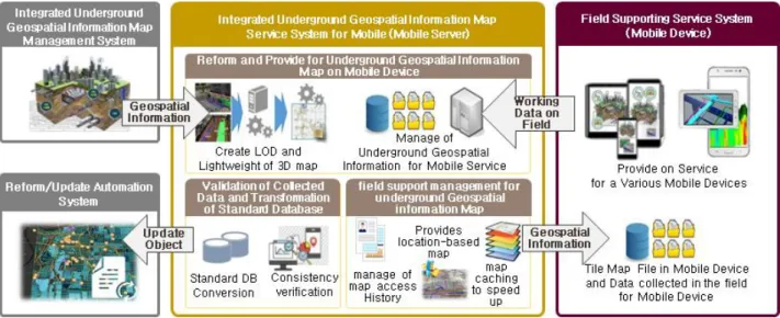
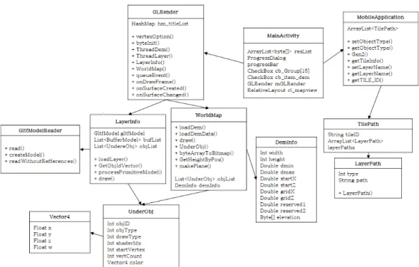
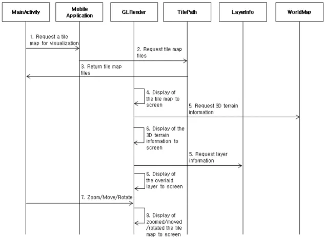
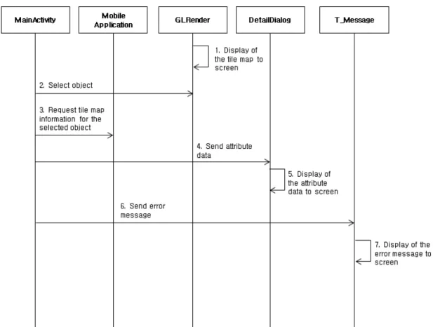
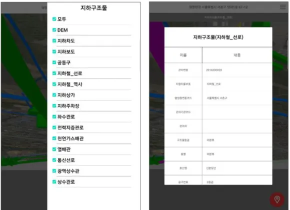
In this paper, we design and implement a service system for mobile devices to utilize the integrated underground geospatial information map in underground exploration fields. The field utilization service system for mobile devices is designed to visualize tiled maps, 3D terrain information, underground structures, underground facilities, and ground information provided by the Integrated Underground Geospatial Information Map Management System according to current position. And It is designed to reflect the results obtained from field exploration in real time. Also, the proposed system is implemented to transfer and visualize the integrated underground geospatial information map in the form of a glTF format due to constraints on wireless networks and device characteristics of mobile devices. Implemented mobile service systems can prevent accidents in underground exploration field from occurring by providing users with accurate and integrated underground geospatial data by visualizing maps and geospatial objects in three dimensions at underground exploration fields. In addition, updated underground geospatial data is transmitted in real time to the Integrated Underground Geospatial Information Map Management Systems, which can maintain up to date and accuracy.
▸Key words: underground geospatial, integrated information map, mobile service system, tile map, 3D visualization
[요 약]
본 논문에서는 지하공간 통합지도를 탐사 현장에서 활용하기 위한 모바일 단말기용 서비스 시스템 을 설계 구현한다 . 모바일 단말기용 현장활용 서비스 시스템은 지하공간 통합지도 관리 시스템에서 제공하는 타일맵 , 3차원 지형정보, 지하구조물, 지하시설물, 지반정보 등을 현재 위치에 따라 3차원으로 가시화하도록 설계되었고, 현장 탐사로 얻어진 결과를 실시간으로 반영하도록 설계되었다. 또한, 제안 된 시스템은 모바일 단말기의 무선 네트워크 및 기기 특성에 따른 제약 문제로 지하공간 통합지도를 glTF 포맷 형태로 전송 후 가시화 하도록 구현하였다. 구현된 모바일 서비스 시스템은 지하공간 탐사 현장에서 3차원으로 지도 및 공간 객체들을 가시화하여 사용자에게 정확하고 통합된 지하공간 데이터 를 제공함으로써 탐사 현장에서의 사고 발생을 방지할 수 있다. 그리고, 갱신된 지하공간 데이터를 실시간으로 지하공간 통합지도 관리 시스템에 전송하여 최신성과 정확성을 유지할 수 있다.
▸주제어: 지하공간, 통합지도, 모바일 서비스 시스템, 타일맵, 3차원 가시화
∙First Author: Sook-Kyoung Cho, Corresponding Author: Sook-Kyoung Cho
*Sook-Kyoung Cho ([email protected]), System Development Div., DBNtech Co., Ltd.
*Yong-Tae Kim ([email protected]), System Development Div., DBNtech Co., Ltd.
**Ja-Young Choi ([email protected]), DBNtech Co., Ltd.
∙Received: 2020. 12. 04, Revised: 2020. 12. 24, Accepted: 2020. 12. 24.
Copyright ⓒ 2020 The Korea Society of Computer and Information http://www.ksci.re.kr pISSN:1598-849X | eISSN:2383-9945