Wind Speed Prediction in Complex Terrain Using a Commercial CFD Code.
Woo,Jae-kyoon* Kim,Hyeon-gi** Paek,In-su*** Yoo,Neung-soo***andNam,Yoon-su***
*Dept.ofMechanicalandMechatronicsEngineering,KangwonNationalUniversity,GraduateSchool,(venimaru@kangwon.ac.kr),
**Dept.ofMechanicalandMechatronicsEngineering,KangwonNationalUniversity,GraduateSchool, (kimhk@kangwon.ac.kr),
**Dept.ofMechanicalandMechatronicsEngineering,KangwonNationalUniversity,Assistantprofessor, Ph.D(paek@kangwon.ac.kr),
**Dept.ofMechanicalandMechatronicsEngineering,KangwonNationalUniversity,Professor,Ph.D(yoonesoo@kangwon.ac.kr),
**Dept.ofMechanicalandMechatronicsEngineering,KangwonNationalUniversity,Professor,Ph.D(nys@kangwon.ac.kr)
상용 CFD 프로그램을 이용한 복잡지형에서의 풍속 예측
우재균*,김현기**,백인수***,유능수***,남윤수***
*강원대학교 대학원 기계메카트로닉스공학과(venimaru@kangwon.ac.kr),
**강원대학교 대학원 기계메카트로닉스공학과 (kimhk@kangwon.ac.kr),
***강원대학교 기계메카트로닉스공학과 조교수,공학박사(paek@kangwon.ac.kr),
***강원대학교 기계메카트로닉스공학과 정교수,공학박사(yoonesoo@kangwon.ac.kr),
***강원대학교 기계메카트로닉스공학과 정교수,공학박사(nys@kangwon.ac.kr)
Abstract
InvestigationsonmodelingmethodsofaCFD windresourcepredictionprogram,WindSim foraccuratepredictions ofwindspeedswereperformedwiththefieldmeasurements. MeteorologicalMastshavingheightsof40m and50m wereinstalledattwodifferentsitesincomplexterrain.Thewindspeedsanddirectionweremonitoredfrom sensors installed on themastsand recorded foroneyear.Modeling parametersofWindSim inputvariablesforaccurate predictionsofwindspeedswereinvestigatedbyperformingcrosspredictionsofwindspeedsatthemastsusingthe measureddata. Fourparametersthatmostaffectthewindspeedpredictionin WindSim including thesizeofa topographicalmap,cellsizesinxandydirection,heightdistributionfactors,andtheroughnesslengthswerestudied tofindoutmoresuitableinputparametersforbetterwindspeedpredictions. Theparameterswerethenappliedto WindSim topredictthewindspeedofanotherlocationincomplexterraininKoreaforvalidation.Thepredictedannual windspeedswerecomparedwiththeaveragedmeasureddataforoneyearfrom meteorologicalmastsinstalledforthis study,andtheerrorswerewithin6.9%. Theresultsoftheproposedpracticalstudyarebelievedtobeveryuseful togiveguidelinestowindengineersformoreaccuratepredictionresultsandtime-savinginpredictingwindspeedof complexterrainthatwillbeusedtopredictannualenergyproductionofavirtualwindfarm incomplexterrain.
Keywords:Parametricstudy,windspeed,complexterrain,WindSim,CFD
투고일자 :2011년 7월 14일,심사일자 :2011년 7월 18일,게재확정일자 :2011년 9월 21일 [논문] 한국태양에너지학회 논문집
Journal of the Korean Solar Energy Society
Vol. 31, No. 6, 2011 IS S N 1 5 9 8 - 6 4 1 1
1.Introduction
Recently,interestson renewableenergy sourcesaregettinghigherduetohighoil
pricescausedbytheearth’senvironmental pollutionanddepletionofthefossilfuel[1-3]. WindEnergyisconsideredasoneofthe most efficient renewable energies,and lots ofnew wind farms are constructed everyyearallovertheworld.
For construction of wind farms,wind resourcesoftheareaofinterestmustbe investigated,beforehand.Accurateanalysis and prediction ofwindresourceespecially incomplexormountainousterrainareimportant becauseitincreasesasthealtitudegetshigher [4-5]. Twopopularcommercialprograms mainlyusedforwindresourceanalysisand predictionareWAsP(WindAtlasAnalysis andApplicationProgram)andWindSim [6]. Because WAsP uses a lineartopographic modelknownasBZ-model,itisknownthatit cannotconsiderflow separationphenomenon thatoften occurson complex terrain. As theresult,WAsP isnotconsidered tobe suitableforwindspeedpredictionincomplex terrain[7-8]. UnlikeWAsP,WindSim isa CFDprogram basedontheReynoldsAveraged Navier-Stokes(RANS)Equation,anditobtains thesteadystatesolutionofathreedimensional computationaldomain ofinterest. Dueto this reason,WindSim is considered more suitabletopredictwindspeedsincomplex terrainthanWAsP [9-13].
AlthoughWindSim isconsideredsuitable topredictwindspeedincomplexterrain,its validationstudyhasbeenlimitedtoseveral Europeancountries,sofar.Also,unlikethe
expectation,thepredictionsfrom WindSim intheliteraturewerenotalwaysmoreaccurate thanthosefrom WAsPdependingonregions. Oneofthemany sources oftheinaccurate resultsfrom WindSim isconsideredduetoan inaccurateWindSim modeling.Howeverstudies ontheaccuratemodelingofWindSim input parametersareveryrare.
Finding suitable design parameters of WindSim are importantfora wind farm design andespecially siting windturbines atoptimallocationsforwindenergyproduction.
Also,duetotheincreasingtrendofconstructing windfarmsincomplexterrains,reliableand practicalmodeling methods to use CFD programssuchasWindSim arenecessary tobeinvestigated.
About70% ormoreoftheKoreanterritory is known to be covered with mountains. However,basedontheliterature,studieson wind resource predictions using a CFD codeinKoreaareverylimited[14].
Therefore,thisstudy wasperformed to fulfilltwogoals.Onewastoestablishaguidance toaccuratelyemploytheCFDcode,WindSim tocomplexterrainsinKoreatoaccurately predictwindspeed.Theothergoalwasto validatetheWindSim modelingandpredictions in complex terrain other than European regions.Inorderforthese,twometeorological mastswereinstalledincomplexterrainin Korea,andthewindspeedanddirectionfor eachmastwererecordedwiththeinterval of10minutesforayear. Then,various modeling parameters of WindSim input variablesforaccuratepredictionsofwind speeds were investigated by performing cross predictions ofwind speeds at the mastsusingthemeasureddata.
2.Modeling
2.1Sites
Asshownin Fig.1,thetwositesused forwindspeedmeasurementandprediction inthisstudyarelocatedincomplexterrain.
Fig.1.TopographyincludingsitesA & B.
ThealtitudeofsiteA,locatedslightlyoff thetopofamountain,is1,147m.ThesiteB inthefigureislocatedontopofamountain anditsaltitudeis1,154m.A meteorological mast(MM)having a heightof40m was installedatsiteA. A 50m highMM was installedatsiteB.Thedistancebetweenthe twomastsinsitesA andBwasabout7.6km.
MostoftheterraininFig.1iscoveredwithtrees. TheRIX(RuggednessIndeX)representing adegreeofcomplexity oftopography [15, 16]wascalculatedandfoundtobe20.63%
and32.23%,respectively,forA andB. A flatsitehasanRIX valueof0%.AnRIX valueof30% meansthataboutonethirdof theterrainissteeperthanthecriticalslope whichisnormally0.3.TerrainhavingRIX valueshigherthan20% isnormallyconsidered highlycomplex.
Theannualaveragedwindspeedmeasured atthesitesA andBwerefoundtobe3.72m/s and5.09m/s,respectively
2.2MeasurementData
The 10 minute averaged measurement dataforoneyearisconvertedintothewell knownWeibullprobabilitydensityfunction forsimplicity. Compared to about52,000 measurementdatasets,Weibullprobability densityfunctionrequiresonlytwoparameters todescribetheannualwindcharacteristics. AsshowninEq.(1),thetwoparametersin Weibullprobabilitydensityfunction,A and k,areknown asthescalefactorand the shapefactor,respectively.
exp
(1)where V is the wind speed,fis the frequencyofoccurrenceofthewindspeed, kistheshapefactor,A isthescalefactor, and exp is the exponentialfunction.The scaleand shapefactorsarerelated tothe wind speed, and its distribution shape, respectively.InWindSim,winddirectionis sectored by a 30 degreeintervaland the parameters A and k to bestdescribethe measurementwindspeedandfrequencyof occurrence are calculated foreach sector. Aslong astheparametersarefound,the windspeedaverageisestimatedusing
(2)where V istheaveragedwindspeedand G isthegammafunctionknownas
∞
(3)
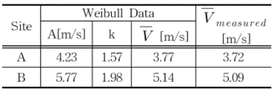
Table1showstheWeibullrepresentation ofthemeasured data ateach site.When converting the measurementdata to the Weibullprobabilitydensityfunction,conversion errors of2.15% and 0.39 % occurred for sitesA and B,respectively.Theseerrors wereconsideredsmallforthisstudy.
Site
WeibullData
[m/s] A[m/s] k [m/s]
A 4.23 1.57 3.77 3.72 B 5.77 1.98 5.14 5.09 Table 1.Measurementdata and Weibullfitted
parameters.
2.3WindSim modeling
WindSim is a CFD program developed solely forapplication to thefield ofwind energyusingthewellknownPhoenicscode [17].WindSim modelstheatmosphereabove the ground as a three dimensionalmesh system andapplythe,time-averaged,RANS equationtoeachcellinthemeshsystem to obtainathreedimensionalwindflow solution.
Thestandardk-epsilonturbulencemodelis normallyused.Unlikeatimestepapproachto solveflow fields,WindSim startsfrom initial boundaryconditionsspecifiedbyusersand obtainatimeaveragedsteady-statesolution.
The three dimensional(3D)calculation domainofWindSim islimitedbythemap boundaries in the horizontal x and y directions,andbythegroundatthebottom andtheupperboundaryheightatthetopin theverticalzdirection.
The atmospheric boundary layerwhere thewindspeedvarieswiththealtitudewas assumed to be500m,which is known in literaturetobethemostusedbyscientists
todescribetheheightofgeostrophicwind [18].Abovetheatmosphericboundarylayer, thewindspeedwasfixedtobeaconstant value,10m/s.Theeffectofaconstantspeed oftheatmosphericboundary layeron the speedpredictionisknowntobesmall[18]. Abovetheatmosphericboundarylayerthere existsanupperlayer.Theupperboundary heightisautomaticallydeterminedbyWindSim depending on sites and high enough to avoid a blocking effecton thewind flow [19]inanylocationsofthemap.Normally, itistheorderofseveralkilometers.
Along thex and y boundary ofthe3D calculation domain below the atmospheric boundarylayer,alogprofileofwindspeed isappliedasaboundaryconditioninWindSim.
Thisisknowntobeequivalenttothefact thatinfiniteplainterrainisconnectedtothe xandyboundaries[19].
The solution procedure from WindSim consistsoftwoparts. Inthefirstpart,it calculatesthewindvelocitiesateachsector andgridpointusingtheprovidedboundary conditionssuch asthewind speed above theboundarylayerheightandthelogprofile ofvelocitywithoutknowingthemeasuredwind data.Afterfinishingthewindfieldcalculation, WindSim knowsthevelocityvectorinany gridpointrelativetotheothergridpoints. In the second phase,WindSim uses the measuredwinddatawhichisthesectorwise windspeedandthefrequencyofoccurrence toobtainthewindvelocity relativetothe measurementpointforthewholemap.
3.ParametricStudy
A totalof four input parameters that
affectthewindspeedpredictionofWindSim wereselectedandusedfortheparametric study.Asmentionedintheprevioussection, two sites located in complex terrain in Koreawereselectedandmeteorologicalmasts wereinstalledtoobtaindataincludingwind speedanddirectionforoneyear.WindSim wasusedtopredictthewindspeedofone siteusing thedatameasuredattheother, viceversa.Whenpredictingwindvelocities, only oneinputparameteroutoffourwas variedandalltheotherswerefixedtobe constants
3.1MapSize
In windresourcepredictionprograms,a map size means the size ofthe solution area,anditdeterminesthesizeoftheterrain informationincludedwhenthepredictionof windresourcearoundacertainpositionof interestismade. Ifthepredictionposition islocated tooclosetothemap boundary, thesurrounding terraininformationcannot be included when the solution to the governingequationismadefortheposition.
Thereforerelativelylargepredictionerroris expected. On theotherhand,ifthemap size is too large,the time required for modelingandanalysisincreasesdramatically.
Alsoduetothelimitedcomputerresources andthelimitednumberofcellelementsthat theprogram canhandle,thecellsizemust getlargerasthemapsizegetslarger.This oftencauseshighpredictionerrors.Therefore, the relationship between the prediction errorsandthemapsizeisveryimportant. However,research on thismatterisvery limitedandcannotbefoundintheliterature.
Fortheparametricstudyofthemapsize,
asshown in Fig.2,thedistancebetween thetwositesand themapboundary was settoL.Then,Lwasvariedfrom 1km to 5km andthewindspeedofA andB were predicted.WhenpredictingthespeedofA,the measureddataatBwasused,andviceversa.
Fig.2.Variationoftopographicalmapsize
Thecellsizein x and y direction was fixedtobe50m. Thenumberofcellsin zdirection waschosen to be30.Forthe z-cellsize,itisrelated tothenumberof cellsin zdirection andheightdistribution factor.The height distribution factor is definedastheratioofthecellsizeatthe groundtothatattheupperboundary.The heightdistributionfactor(HDF)waschosen tobe0.01.AstheHDFdecreases,thecells inzdirectiongetclosertotheground.
AsshowninTable2andFig.3,asthe mapsizechanges,thewindspeedprediction alsochanges. Whenthedistancebetween thepredictionsiteandthexandyboundaries ofthemapwasbetween1km and3km,the
changeratesoftheprediction werelarge. Asthemapsizefurtherincreased,therate decreased,andbecamelessthan0.8% when themapsizereached5km.
Fig.3.Change Rate ofWind speed predictions for differentmapsizes.
MapSize[km]
1 2 3 4 5
A→B[m/s] 5.41 5.26 5.09 5.02 4.98 B→A[m/s] 3.81 3.86 3.91 3.92 3.94 CellNo.[x103] 59.5 98.9 147.8 206.4 274.5 Cal.time[hour] 6.0 9.5 14 22 28.5 Table 2.Predicted wind speed with change ofmap
sizes.Dimensionsinm/s.
Thisisduetobethefactthatthelog profileofwindshear(horizontalwindspeed overheight)usedasaboundarycondition bytheWindSim program causeserrorsin predictingwindspeedsoflocationsnearthe
xandyboundaries.A logarithmicprofileof wind shear is known to occur at flat terrains,thereforeapplyingthatprofileasa boundaryconditiontotheboundariesofthe map impliesthatthegiven topography in themapissurroundedbyflatterrains.Thisis, however,differentfrom theactualtopography.
Ifthemapsizeissmall,thepredictionsite is notfarenough from the artificialflat terrain created by theboundary condition andthelogarithmicprofileattheboundary willaffectthe actualprofile on complex terrain. Ifthemap sizeislargeenough, however,although the topography ofthe map is surrounded by flat terrains,the effectoftheflatterrainonthewindshear will disappear for regions that are far enoughawayfrom themapboundaries.
Asthemapsizeincreases,thesitesA &
B getsfurtherandfurtheraway from the boundaries,andtheeffectofthelogprofile boundary condition on the wind speed predictiongetssmallerandsmaller.Therefore ifthechangeinpredictionerrorsareconsidered, thedistancebetweenthepredictionsiteand themapboundaryshouldbeatleast5km orlarger.
However,asthemapsizeincreased,the numberofcellsusedinthesimulationincreased, andfinallythecalculationtimeconsiderably increased,too.Therefore,itshouldbecareful notto have themap size too big foran efficientcalculation.
3.2CellSize
A parametricstudyofthecellsizewas performed.Themapsizewassettobe5km basedonthefindingsintheprevioussection.
Thecellsizewasvariedregularlywithan
intervalof25m from 100m to50m.Asthe cellsize decreased,the number of cells increased.Duetothelimitedcellnumbers thatWindSim canhandle,acellsizeof25m wasn'tbepossible.Inordertomakethecell sizeslightlysmallerthan50m,a“refinement” optioninWindSim wasused.Thesmallest cellsizeachievedwas30.5m.Iftherefinement areaisselectedinthemap,asmallerconstant cellsizeisappliedinsidetheareaandthe cellsizesgradually getlargerastheyget furtherawayfrom thearea.Therefinement areawassettobe1km awayfrom boththe measurementmastandthepredictionposition asshowninFig.4.
Fig.4.Topographicalmapforparametricstudyofcellsize.
As shown in Table 3 and Fig.5,the resultshowsthatasthecellsizedecreases, the wind speed prediction from WindSim approachesthemeasuredvalue.Alsowhen the cell sizes changed from 30.5m to 100.0m,thechangeinwindspeedprediction waswithin2.36%. Althoughthechange rateofpredictionlookssomewhatlarge,a smallercellsizecouldn'tbeachieveddueto thelargesizeofthemap.
CellSize 30.5 50.0 75.0 100.0 A=>B [5.09m/s] 5.09 4.97 4.9 4.8 ChangeRatefrom
5.09m/s[%] - 2.36 3.73 5.70 B=>A [3.72m/s] 3.88 3.95 3.99 4.06 ChangeRatefrom
3.88m/s[%] - 1.80 2.84 4.64 CellNumber[x10,000] 27.6 27.5 12.1 6.9
Cal.Time[hour] 30 21 8 4.3 Table3.Predictedwindspeedwithchangeincellsize.
Fig.5.Predictedwindspeedfordifferentcellsizesinx andydirection.
Thereasonwhythewindspeedprediction from the program is affected by the cell sizeisthatthecellsizeisconsideredasthe resolutionoftheterrainmodelwhichdepicts theactualterrain.AsshowninFig.6,ifthe cellsizeislarge,theresolutionoftheterrain modelbecomeslow. Forflatterrains,the low resolutionoftheterraindoesn'tplaymuch roleonthewindspeedprediction because
theactualterraincanbeaccuratelydepicted bythelow resolutionterrainmodel.
However for complex terrain,the low resolutionoftheterrainmodelwillactually changethetopographyoftheterrainfrom theactualtopographyoftheterrain,andasa result,themountainsmightbecomesubstantially lower.
Fig.6.Terrainaccordingtocellsize
This,intheend,affectsthepredictionof theterrain.
The topography of the terrain model neverbecomesexactlythesameasthatof theactualterrain becausethecellsizeis finite.However,asthediscrepancydueto the finite resolution decreases,the wind prediction errors associated with it will decreasesandintheendwillbewithina certainerrorlimit.
3.3Z-cellNumbersandHDF
Bothcellnumbersinzdirectionandheight distribution factorsarerelated to thecell size(resolutionofthesolution)inzdirection.
Theupperboundaryofthethreedimensional solutiondomainisautomaticallydetermined byWindSim highenoughtoavoidablocking
effectonthewindflow.Incomplexterrain, the upperboundaries often reach several kilometers.Asmentionedbefore,theheight distributionfactor(HDF)isdefinedasthe ratioofthecellsizeatthegroundtothat atthe upperboundary.The ratio ofthe height/width/length between thefirstand lastcellaccording to HDF is defined as [19]
∆
(4)
and
∆
∆
(5)
In Equations (4) and (5), L is the distance over which the distribution is applied,nisthenumberofelements(cells) withinL,cistheheightdistributionfactor andequalstoh1*,hn*,,h1*,isthesizeofthe firstelement(height/width /length of firstcell),and hn*- The size ofthe last element(height/width/lengthoflastcell)
As the HDF decreases,the cells in z directiongetclosertotheground.Therefore, itdeterminesthecellsizesinzdirectionin conjunctionwiththezcellnumbers.
Forwindenergyapplications,thesolution especiallylowerthan500metersareimportant, because the maximum height from the groundtothetipoftherotorbladeofmodern multi-megawattwindturbinesislessthan 300meters. Moreover,forthisstudy,the measurementheights ofthe wind speeds anddirectionfrom meteorologicalmastsare 40and50meters,thereforeitisimportantto findoutasuitablezcellresolutionrelatively
closetotheground.
Forthesimulation,thecellnumberinz directionwasfixedtobe30andtheHDF wasvaried. Themapsizewas5km,and thecellsizeinxandydirectionwas30.5 m withrefinementoption,likebefore.Table4 showsthefirstfivecellheightsfrom the ground in z direction for three different HDFvalues. ForeachHDFvalue,Minand Maxmeansthelocationswherethedistance betweenthealtitudeofthegroundandthe upperboundaryareminimum andmaximum, respectively.Forotherlocations,thecellheights inzdirectionarebetweenthevaluesofMin andMax.
Distance[m]
1 2 3 4 5
1.0 Min 69.8 209.5 349.2 488.8 628.5 Max 89.0 267.0 445.0 623.0 801.0 0.5 Min 46.6 141.3 239.2 340.3 444.7 Max 59.3 180.0 304.8 433.7 566.7 0.01 Min 1.4 8.9 25.8 52.2 88.0
Max 1.8 11.3 32.9 66.5 112.1 Table 4.Cellheightin z direction with various HDF
(HeightDistributionFactor).
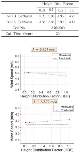
TheresultisshowninTable5andFig7. Ascanbeseeninthetable,thevariations weresmallbutwhen theHDF was0.01, the wind speed prediction from WindSim wastheclosesttothemeasuredvalue.As thelowestcellheightdecreasesfrom 69.8m~
89.0m to 1.4m~1.8m,the prediction errors decreased.AlsowhentheHDFreached0.1, thelowestcellheightbecamelowerthan the prediction height,and the changes in prediction valuesforthecasesof0.1and 0.01inHDF wereverysmall.
HeightDist.Factor 0.01 0.1 0.5 1.0 A=>B (5.09m/s) 5.09 5.06 4.95 4.75 B=>A (3.72m/s) 3.88 3.88 3.99 4.11
CellNo. 2,764,000 Cal.Time(hour) 30
Table 5.Predicted wind speed with change in heightdistributionfactor.
Fig.7.Predictedwindspeedfordifferentcellsizesinz direction.
Forthez-cellsize,Thisisconsidereddue tobethefactthataslongasthewindflow solutions are obtained at the lower and uppercellscomparedwiththemeasurement or prediction height,the solution at the heightofinterestisobtained similarly by interpolationregardlessofthenumberofcells lowerthan themeasurementorprediction height.Therefore,when the prediction or measurementheights are low,itis very
importantto adjustthe cellnumberin z directionandtheheightdistributionfactor tomakesurethatthefirstcellheightinz direction is lower than the prediction or measurementheight.
3.4RoughnessLength
The roughness length represents a friction from the ground surface which affectsthewindvelocity,anditvarieswith differentstateoftheterrain.Generallywater surfacehasthesmallestroughnesslength andthecenterofalargecitysurroundedby tallbuildings has the biggestroughness. Forthisstudy,alltheanalysesaremade forcomplexterrainasshownpreviouslyin Fig.1.
Theroughnesslengthsrecommended in literature forcomplex terrain are slightly differentasshowninTable6.Thereason why differentroughnesslengthsexistfor complexterrainisthattheroughnesslength ofcomplexterraindependsontheheights, leavesanddensityoftrees.
Literature Rough.L.[m]
Dev.WindPow.Proj.[20] 0.3– 0.5 WAsP[6] 0.4 Int.WindE.Eng.[21] 0.5 Table6.Roughnesslengthvariationforforests.
Theroughnessalsodependsontheclimate ofthecomplexterrain.Inotherwords,the roughnesslengthisthelargestintheSummer. Tofindasuitableannually-averagedroughness length on forest,the parametric study of roughnesslengthwasperformed.Theroughness lengthwasvariedregularlywiththeinterval 0.1m from 0.3to0.5.
TheresultisshowninTable7andFig8. When the prediction ofwind speed was performedfrom siteA tositeB,thebest result was obtained with the roughness lengthof0.4m.However,fortheprediction from siteB tositeA,thebestresultwas obtainedwiththeroughnesslengthof0.5m buttheprediction wasvery closetothat withtheroughnesslengthof0.4m.
Fig.8.Predicted wind speed fordifferentroughness length
RoughnessLength(m) 0.3 0.4 0.5 A=>B (5.09m/s) 5.07 5.09 5.13 B=>A (3.72m/s) 3.89 3.88 3.87 Table 7.Predicted wind speed with change in
roughnesslength
3.5SuitableParameterSelection TheselectedparametersforabetterWindSim prediction,obtainedfrom theparametricstudy arepresentedinTable8.
Table8.Selectedparameters Parameter Value 1.MapSize 5km 2.x,yCellSize 30.5/34m 3.zCellNumbers 30 4.HeightDist.Factor 0.01 5.RoughnessLength 0.4m
Theywereusedforwindspeedpredictions andtheresultsareshowninTable9.
Table9.Resultswithoptimizedparameters Measured Predicted Error(%) A=>B 5.09 5.13 0.78 B=>A 3.72 3.87 4.0 CellNo. 2,764,000
Cal.Time(hour)Modeling Simulation Total 24 31.3 55.3
As shown in the table,the prediction errorwas0.78% whensiteB waspredicted using thedatameasuredatsiteA,andit became4.0% whensiteA waspredictedusing thedatameasuredatsiteB. Considering thatsitesA andB arelocatedincomplex terrain,theresultsarefoundtobeexcellent. Forthecalculationtime,ittookaboutthree daystocompletetheWindSim simulation withacomputerhavingaquadcoreprocessor, 16 Giga bytes ofmemory and a 64-bit operatingsystem.
4.VALIDATION
Foravalidationoftheresult,ameteorological
masthavingaheightof50m wasinstalled atalocationnamedsiteC withanaltitude of876m incomplexterraininKoreaandthe parameters obtained from the parametric studywereused. TheRIX valueofsiteC was37.80%,which meanstheterrain is highly complex.The predictions ofwind speed weremadeforC from both A and B.Thefirstcaseincluded sitesA and C andwasnamedlocationI.Thesecondcase included sites B and C and was named locationII.Descriptionsofthetwolocations are presented in Fig.9.The measured annualwindspeedforsiteC was4.22m/s. Forthetwolocations,thetwositeswhere meteorologicalmastsareinstalledareseparated by21km and24.6km,respectively.
(a)LocationI
(b)LocationII
Fig.9.Topographyofapplicationlocations.
ForthetwolocationsIandII,themap sizes are larger than that used for the parametricstudybecausethedistancebetween thetwomeasurementsitesare21.0km and 24.6km,respectively,andthereforethecell sizehadtobelarger.InWindSim,thecell size cannotbe specified by the userbut ratherdeterminedbythemapsizeandthe maximum allowablecellnumbers.Therefore itcouldn’tbepossibletosetthecellsize exactlythesameforalldifferentlocations. Thecellsizewasselected tobecloseto 75m forcomparison.Table10 shows the parametersusedforthesimulation.
Table 10.InputParameters forparametric study and validation
Study LocationILocationII MapSize(X*Ykm) 14x17 24x22 20x28
x,yCellSize 30.5x34.0 74.0x84.0 78.0x77.0 zCellNumbers 30 30 30
HDF 0.01 0.01 0.01
Asshown in Tables11and 12,forthe twocases,thepredictionerrorswerewithin 6.9%.Thepredictionresultsareconsidered excellent because the measurement and predictionsitesareabout25km awayand locatedbothincomplexterrain.
Table11.PredictionresultsforLocationI Measured
(m/s)
Predicted (m/s)
Error (%) A=>C 4.22 4.02 4.7 CellNo.(x103) 195.7
CalculationTime(h)
Modeling Simulation Total 24 18.7 42.7
Table12.PredictionresultsforlocationII Measured
(m/s)
Predicted (m/s)
Error (%) B=>C 4.22 3.99 6.9 CellNo.(x103) 185.1
CalculationTime(h)Modeling Simulation Total 24 14.1 38.1
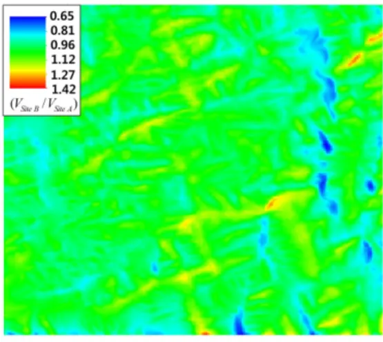
Figure10showsthecontourmapsobtained usingthedatafrom SiteA andSiteB.As shown in the figure,the two results are consistentandveryclose.
Fig.10.WindResourcemap(Velocitycontour)
Table13 showsthecomparisonsofthe windspeedpredictionsfrom WindSim and alinearcodecommonlyusedtowindspeed prediction for a wind farm construction [22].
Table 13.Comparison ofthe prediction results with thosefrom alinearcode
Error(%) WindSim
LocationI LinearCode A=>B 0.78 4.52 B=>A 4.0 15.32 A=>C 4.7 11.85 B=>C 6.9 7.58
Thesamemapsizeandroughnesslength with a higherresolution were used. As canbeseenfrom thetable,thepredictions from the CFD code were consistently betterthanthosefrom thelinearcode.
Therefore,thisvalidatesthattheresults from the parametric study are useful enough tobeusedforWindSim modeling topredictwind speedsin complex terrain in Korea. Also,itshowsthattheresults from WindSim are accurate in predicting windspeedsincomplexterraininKorea.
5.CONCLUSION
Investigationsonfinding suitabledesign parametersofWindSim and itsvalidation forwindspeedpredictionincomplexterrain ofKorea were performed.Meteorological masts were installed to measure wind speedanddirectionforoneyearatvarious locations, and the data measured were impliedfortheparametricstudy.Fourdifferent inputparametersselected werestudied to findouttheoptimaldesignvaluesforwind speedpredictions.Theresultsoftheparametric studyareasfollows:
(1)Forthemapsize,thedistancefrom the map boundary and the prediction site wasfoundtobeatleastlargerthan5 kilometers. Thisisduetobethefact thatthelogwindprofileboundarycondition used in WindSim produces errors in predicting wind speeds nearthe map boundary.
(2)Forthehorizontalcellsize,itwasfound thatforthe cellsize less than about 70m,thechangeinwindspeedprediction wassmall(lessthan4%)althoughthe
cellsize was changed from 75m to 30.5m. The wind speed prediction converged when the cellsize became about36m.However,whenthecellsize changed from 75m to 30.5m, the calculation time increased more than threetimes.
(3)ForthezcellnumberandtheHDF,it was found thatatleastthe firstcell heightfrom theground determined by the two factors should be lowerthan the measurementor prediction height foraccurate prediction ofwind speed.
Aslongasthefirstcellheightfrom the groundislowerthanthemeasurement height and the prediction height,the predictionresultswerealmostthesame although the second orthe third cell heightishigherthanthemeasurement orpredictionheight.
(4)Fortheroughnesslength,valuesof0.3m to0.5m wereconsidered based on the literatureandavalueof0.4m wasfound tobethebestforthecomplexterrainin Korea.
For validation ofthe parametric study results,theparametersobtainedfrom thestudy wereappliedtopredictthewindspeedof another site in complex terrain,and the resultswerecomparedwith themeasured data.Forallthecases,theWindSim prediction errorsforwindspeedwerelessthan6.9%.
Alsothesepredictionerrorswerefoundto bemuchsmallerthanthosefrom thelinear code commonly used to predictthe wind speed fora wind farm construction.The resultsoftheproposedpracticalstudyare believedtobeveryusefultowindengineers for more accurate prediction results and
time-saving in predicting wind speed of complexterrainthatwillbeusedtopredict annualenergyproductionofavirtualwind farm in complex terrain.However,in this studyonlyonesiteinKoreancomplexterrain were considered forvalidation.Therefore, morevalidationstomoresitesincomplex terrainarenecessarytoprovethefindings inthisstudy.
Acknowledgement
ThisworkwassupportedbytheNew &
RenewableEnergyoftheKoreaInstituteofEnergy TechnologyEvaluationandPlanning(KETEP) grantfundedbytheKoreagovernmentMinistry ofKnowledgeEconomy.
(No.20093021020030).
REFERENCES
1.K.H.Yoon,A StudyontheChangesof theUSEnergyPolicyandtheExpansion oftheNew andRenewableEnergy,J.of KoreanReg.Dev.8(2008)151-179. 2.J.S.Hwang,H.J.Lee,S.H.Park,Green
IT Policies for Low Carbon, Green Growth,J.ofKoreanAssoc.forInform.
Soc.14(2008)3-28.
3.J.B.Kil,B.K.Jung,GreenGrowthand Environment-EconomyIntegration:Between ModificationandTransition,J.ofKorean Inst.ofGov.Studies,15(2009)45-71.
4.J.M.L.M.Palma,F.A.Castro,L.F.Ribeiro, A.H.Rodrigues,A.P.Pinto,Linearand nonlinearmodelsinwindresourceassessment and windturbinemicro-sitingin complex terrain,J.ofWindEng.andInd.Aerodyn.
96(2008)2308-2326.
5.A.Llombart,A.talayero,A.Mallet,and E.Telmo,PerformanceAnalysisofWind ResourceAssessmentProgramsinComplex Terrain,Int'l.Conf.onRenew.Energies andPowerQual.,2006.
6.RisoeLaboratory,availableonlineat http://www.wasp.dk/,last last seen in March2010.
7.P.Moreno,A.R.Gravdahl,andM.Romero, WindFlow overComplexTerrain:application of Linear and CFD Models,European WindEnergy Conf.andExhib.,Madrid, 2003.
8.T.Wallbank,WidSim ValidationStudy, CFD validationinComplexterrain,2008.
Availableonlineathttp://web.windsim.com /library/papers--presentations.aspx, lastaccessedinMarch2010.
9.G.Waston,N.Doublas,S.Hall,Comparisonof WindFlow ModelsinComplexTerrain,World Renew.EnergyCongr.,2005.
10.K.Yoon,I.Paek,N.S.Yoo,WindSpeed Prediction using WAsP for Complex Terrain,Proc.ofthe2008autumnConf. ofKoreaWindEnergyAssoc.,2008.
11.S.-W .Kim,H.-G.Kim,Sensitivity AnalysisofWindResourceMicrositing attheAntarcticKingSejongStation,J. ofthe Korean Solar Energy Soc.27 (2007)1-9.
12.R.Cattin,B.Schaffner,S.Kunz,Validation of CFD Wind Resource Modeling in Highly Complex Terrain, European WindEnergyConf.,Athens,2006.
13.J.Maza,G.Nicoletti,"CFD-RANS applicationsincomplexterrainanalysis. Numericalvs experimentalresults.A casestudy:Cozzovallefondiwindfarm inSicily"EuropeanWindEnergyConf.,
Athens,2006.
14.Y.Hwang,I.Paek,K.Yoon,W.Lee,N.
YooandY.Nam,“Applicationofwind data from automated weatherstations towindresourcesestimationinKorea,” Journal of Mechanical Science and Technology,2010.
15.N.G.Mortensen and E.L.Peterson,
“Influenceoftopographicalinputdataon theaccuracyofwindflow modelingin complexterrain,”RisØNationalLaboratory, Roskilde,Denmark
16.A.J.BowenandN.G.Mortensen,“WAsP predictionerrorsduetositeorography,” RisØ National Laboratory, Roskilde, Denmark,2004.
17.Availableonlineatwww.cham.co.uk ,last seeninMarch2010.
18.D.Fallo,“windenergyresourceevaluation in a site of central Italy ny CFD simulations”,Ph.D.Dissertation,Univ.
ofCagliari,DiMeCa,2007.
19.WindSim 4.8.1Gettingstarted,WindSim AS,Norway,2008.
20.DevelopingWindPowerProject
21.G.N.Kor,J.Ch.Huh,Introductionof WindEnergyEngineering,Munundang, Korea.2008.
22.WindPRO Manual