1. IntroductIon
Satellite Based Augmentation System (SBAS)는 Global Positioning System (GPS) 신호를 이용한 사용자의 위치 및 시 각 결정 시 정확성, 연속성, 무결성, 가용성 측면에서 높은 신뢰 도를 보장할 수 있도록 하는 위성항법보강시스템이다. 미국의 Wide Area Augmentation System (WAAS), 유럽의 European Geostationary Navigation Overlay Service (EGNOS), 일본의 Multi-functional Satellite Augmentation System (MSAS), 인 도의 GPS-Aided GEO Augmented Navigation (GAGAN)이 운 영 중에 있으며, 러시아의 GLONASS System for Differential Correction and Monitoring (SDCM), 중국의 BeiDou Satellite- Based Augmentation System (BDSBAS)도 개발 및 구축 중에 있 다 (Park et al. 2016). 2014년 10월 한국형 위성항법보강시스템인 Korea Augmentation Satellite System (KASS)은 개발 및 구축 사 업이 착수되었으며 현재는 전세계에서 7번째 서비스 제공자로 등록되었다 (ICAO 2020, Lee et al. 2020).
국제민간항공기구인 International Civilian Aeronautical Organization (ICAO)는 SBAS 신호를 표준으로 규정하고 있
The Korea Augmentation Satellite System (KASS) is a Korean Satellite Based Augmentation System (SBAS) that has been under development since 2014 with the goal of providing Approach Procedure with Vertical guidance (APV)-I Safety of Life (SoL) services. KASS Control Station (KCS) is a subsystem that controls and monitors KASS systems. It also serves to store data generated by KASS. KCS has now completed detailed design and implementation and verification is in progress. This paper presents verification procedures and verification items for KCS verification activities and presents management measures for defects occurring during the verification phase.
Keywords: KASS, SBAS, KCS, verification
으며, KASS 시스템은 ICAO에서 발행한 Standards And Recommended Practices (SARPs) Annex10에 제시되어 있는 SBAS 항공기 운항 모드에 따른 SBAS 요구사항을 따른다. KASS 시스템은 수직유도 정밀접근절차인 Approach Procedure with Vertical Guidance-I (APV-I)급 성능을 목표로 하며 대한민국 비 행정보구역인 Flight Information Region (FIR)에 제공되는 KASS 시스템 서비스의 성능은 Table 1과 같다 (Authie et al. 2017, You
& Sin 2017).
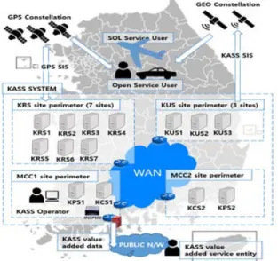
KASS는 KASS Control Station (KCS), KASS Reference Station (KRS), KASS Processing Station (KPS), KASS Uplink Station (KUS)와 Geostationary Earth Orbit (GEO) 위성으로 구 성되어 있다. 전국에 설치된 KRS는 GPS 위성 신호를 수신하여 KPS로 전달하고, KPS는 전달받은 GPS 신호를 이용하여 GPS 보정정보와 무결성 정보를 포함하는 KASS 메시지를 생성한다.
KPS에서 생성된 KASS 메시지는 KUS로 전달되며 KUS는 GEO 위성으로 KASS 메시지를 전송한다. GEO 위성은 KASS 메시지 를 사용자에게 송신하고 사용자는 수신한 KASS 메시지를 사용 자 위치계산 시 오차를 보정하는데 사용한다 (Kim et al. 2017).
Fig. 1은 KASS 시스템 구성과 서비스 개요를 보여준다.
KCS 역할은 하위시스템을 24시간 실시간 제어 및 모니터링하 며, KASS 시스템에서 생성된 데이터를 저장하는 것이다. KCS의 Received May 11, 2021 Revised Aug 11, 2021 Accepted Aug 18, 2021
†