This is an Open-Access article distributed under the terms of the Creative Commons Attribution Non-Commercial License (http://creativecommons.org/licenses/
†
*
This study was supported by the World Bank in 2010.
Eun Hyung Kim, Professor, Landscape Architecture, Gachon University. [email protected]
A Study on the Strategic NSDI Model for Developing Countries based on Korean Experiences
한국의 경험을 통한 개발도상국 NSDI 전략적 구축 모델에 관한 연구
Eun Hyung Kim
김은형
*
요 약 본 논문은 한국의 NSDI(National Spatial Data Infrastructure) 구축경험에 비추어, 개발도상국의 전략적인 NSDI 구축모델을 제시하고자 하였다. 1950년 한국전쟁 이래, 매우 짧은 기간 동안 원조수혜국에서 원조공여국으로 눈 부신 경제성장을 이끌어낸 한국의 NSDI 구축경험은 개발도상국에게 시사하는 바가 크다. 따라서 연구방법으로 한국에 서 NSDI 구축관련 경험이 있는 전문가의견 조사 및 한국 NSDI관련문헌조사를 수행하였다. 본 논문은 관련 문헌조사를 통해 SDI(Spatial Data Infrastructure)에 대한 개념 및 이론적 고찰을 수행하고, 이론적 고찰을 배경으로, SDI의 6개 구성 요소 관점에서 전문가조사결과 등의 시사점을 모았으며. 개발도상국을 위한 NSDI 전략적 구축 모델로 구성된다. 본 논 문의 핵심인 구축모델은 (1) NSDI 구현전략: 지리데이터, GIS능력배양, 지리정보 플랫폼, 파트너쉽을 통한 비용효율적 인 지리정보관리의 4가지 관점, (2) 3단계에 걸친 주요 NSDI 세부 역할과 활동들, (3) 성공적인 NSDI구축을 위한 조화 로운 추진방법으로 구성된다.
키워드:개발도상국, 공간정보기반, 국가공간정보기반 구축모델, 국가공간정보기반 전략, 조화된 NSDI추진방법
Abstract This study aims to establish a strategic NSDI (National Spatial Data Infrastructure) model for developing countries based on good practices in the Republic of Korea. The Republic of Korea is a unique country in the world, which has become a developed country from a recipient of international aid since the Korean War in 1950. The rapid economic growth can be mostly attributed to the IT technologies and the Republic of Korea’s NSDI efforts as a good practice could provide useful lessons for developing countries. This study consists of theoretical reviews, interviews of Korean NSDI experts, analysis for lessons learned, a summary of the lessons in terms of Six NSDI components and finally a strategic NSDI model for developing countries. The NSDI model is structured by (1) implementation strategies suggested for geospatial data, capacity building, geospatial platform, and cost-effective management with partnership, (2) a roadmap of important NSDI tasks and activities, and finally, (3) a harmonized approach for successful NSDI implementation.
Keywords : Developing countries, SDI, NSDI implementation model, NSDI strategies, Harmonized NSDI approach
1. Introduction
After several decades of NSDI(National Spatial Data Infrastructure) trials and errors in the developed countries, many lessons can suggest shortcut strategies for developing countries in their implementations of NSDI - technologies, policies, standards, and human resources necessary to acquire, process, store, distribute and improve utilization of spatial data.
The Republic of Korea became a developed country from a developing country* in the shortest period. The experience from the two different status can form a
unique characteristic for the Korean NSDI and contribute to improvement of building NSDI in developing countries. It can be assumed that advanced IT and GIS technologies have contributed quite much to the rapid economic growth in Korea. World Bank selected the Korean NSDI as a good practice and intended to learn lessons to have a shortcut strategy for better investment in developing countries.
This study begins with theoretical reviews, using
interviews of the Korean NSDI experts and related
NSDI documents. Analysis of lessons learned and
SWOT analysis are conducted as a basis for the
strategic model later. Lessons are summarized in six NSDI components: framework data, standard, access and metadata, human resources and law/institution, technology, and partnership. From these efforts a strategic NSDI model is established as follows: (1) implementation strategies, (2) a roadmap of important tasks and activities, and (3) a harmonized approach for successful NSDI implementation.
*
2. Theoretical Review
2.1 Concepts of SDI
According to the Global Spatial Data Infrastructure Association Cookbook (Nebert, 2004), the term Spatial Data Infrastructure (SDI) is often used to denote the relevant base collection of technologies, policies and institutional arrangements that facilitate the availability of and access to spatial data.[15] Rajabifard (2002) describes SDI as an enabling platform based on dynamic,
hierarchic concept with the aim of facilitating and coordinating the exchange and sharing spatial information between different stakeholders [17]. SDI, as a minimum infrastructure, includes applications, standards, technology and institutional governance necessary for effective and efficient spatial data and services management within or across organizations.
As seen in the previous definitions, the concept of SDI is different within various contexts of political, social, administrative and technical environments; however, its ultimate objectives are to promote economic development, stimulate better government and foster
*Developing countries are, in general, countries that have not achieved a significant degree of industrialization relative to their populations, and have, in most cases, a medium to low standard of living.
The development of a country is measured with statistical indexes such as income per capita (per person) (gross domestic product), life expectancy, the rate of literacy (ignoring reading addiction), et cetera.
For example, the World Bank classifies countries into four income groups. These are set each year on July 1. Economies were divided according to 2011 GNI per capita using the following ranges of income: Low income countries had GNI per capita of US$1,026 or less. Lower middle income countries had GNI per capita between US$1,026 and US$4,036. Upper middle income countries had GNI per capita between US$4,036 and US$12,476.
High income countries had GNI above US$12,476. The World Bank classifies all low- and middle-income countries as developing but notes, [4]
environmental sustainability [12].
SDIs provide the framework for optimization of the creation, maintenance and distribution of geographic information at different organization levels (e.g., regional, national, or global level) and involve both public and private institutions. SDI is fundamentally about facilitation and coordination of exchange and sharing spatial data, services and other resources between stakeholders in the spatial community.
These definitions of SDI can be applicable in the Republic of Korea’s NSDI, and Choi et.al(2009) has also defined in a Korean perspective that SDI is the framework for the optimization of creation, maintenance and distribution of geographic information including all of the logical and physical platform for spatial data, standard, access, policy, human resources and technologies [1].
2.2 Components of SDI
SDI components used by the U.S. Federal Geographic Data Committee include technologies, policies, standards, human resources, and related activities necessary to acquire, process, distribute, use, maintain, and preserve spatial data[6]. Coleman and McLaughlin(1998) define components of SDI as sources of spatial data, database and metadata, data networks, technology, institutional arrangement, policies and standards and end-users[2].
Rajabifard (2002) asserts that data, people, standards, policy and access network are included in SDI[18].
Among the various definitions and components of SDI that are mentioned above, six components are chosen for the Korean NSDI: framework data, metadata
& access (clearinghouse), standards, technology, human, resources, law/institution and partnership to support GIS applications and industries (Figure 1).
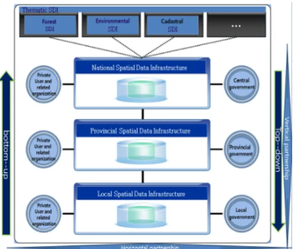
2.3 SDI Hierarchy
An SDI hierarchy is made up of inter-connected SDIs at corporate, local, state/provincial, national, regional (multi-national) and global levels (Figure 2).
Rajabifard (2002) explains that SDI hierarchy creates
an environment in which decision-makers at any level
can draw on data from other levels. The necessary
themes, scales, currency and coverage of the data
depend on different levels of SDI hierarchy [17].
Figure 1. The Korean NSDI Components (MLTM, 2010)[14]
Figure 2. SDI hierarchy[18]
Figure 3. The Korean NSDI hierarchy
In the SDI hierarchy, the SDI at a national level has stronger relationships and plays a significant role in building SDI in other levels. Thus, the Korean NSDI should be taken into consideration in the SDI hierarchy, in which vertical and horizontal relationships are interconnected (Figure 3). The Republic of Korea‘s NSDI hierarchy allows different levels of SDIs to connect vertically and horizontally. For an example of
vertical interconnection, spatial data such as topographic maps are integrated, covering different scales. GIS applications at a national level are also vertically connected with those at a local level, such as UPIS(Urban Planning Information System), Underground Facilities Management Systems. Horizontally, the six NSDI components mentioned are interrelated at each level including a national, a provincial, and a local level.
Lastly, harmonization of both vertical and horizontal partnership in the SDI hierarchy is a key component for successful SDI.
2.4 Evolution of SDI
Loenen(2009) retrospects that the focus of SDIs has moved from data orientation in the 1990s to process orientation in the late 1990s-2005 towards service- oriented SDIs exemplified by the INSPIRE directive in Europe and the spatially enabling government initiative in Australia [11].
The evolutionary trends are summarized by Masser (2005), as follows[13]:
• From a product to a process model,
• From formulation to implementation
• From data producers to data users
• From database creation to data sharing
• From centralized to decentralized structures
• From coordination to governance
• From single to multi-level participation
• From existing to new organizational structures
In the Korean NSDI, most of the evolutionary trends mentioned are included. For example, in the 1st phase of NSDI, there is a focus on data creation and production of dataset such as digital topographic and thematic maps, but later in the 2nd and 3rd phases more efforts were made on data sharing [14].
For the future SDI evolution toward the information/
knowledge society, the Korean NSDI can evolve as suggested in the 4th-phase National GIS Master Plan (2010-2015)(Table 1.).
3. Analysis for the Lessons Learned
To analyze lessons learned experts' interview and
Table 1. Evolutionary characteristics in the 4th Phase the Korean NSDI (Source: MLTM, 2010)[14]
Present Future
IT Environment Digital Ubiquitous Type of
Information 2D, Static 3D, Dynamic Subject Supply-Driven Demand-Driven Types of Business Individual Cooperative
Data policy Close, Limited Open Policy Information
Domain Stand alone Linkage ․
Integration
Table 2. Six SDI components and eleven issues Six components of
SDI
Eleven issues in current Korean SDI situation
data data sets issue
standard standards issue
access and
metadata access issue
human resources, law/institution
policy issues, legislation, organizational issues, and education/research issues technology software and network services
issues
partnership funding, international issues, evaluation
SWOT analysis were conducted. Before getting into the analysis, 11 issues are identified to describe the current Korean NSDI situation: policy issues, legislation, organizational issues, funding, data sets, standards, software and network services, access issues, international issues, evaluation and education/research (The World Bank provided most of the issues to investigate.). The issues are combined into six SDI components mentioned earlier: (framework) data, standard, access and metadata,
human resources and law/institution, technology and partnership. Six components of NSDI are derived from the 4th NGIS Master Plan (Table 2.) to accommodate the eleven issues to describe the Korean NSDI better.
3.1 Interview with Korean GIS Experts The Korean GIS experts’ interview was conducted to figure out proper NSDI strategies for developing
countries. Twenty Korean GIS experts with more than 10 years of the NSDI experience in the public and private sector provided useful answers to the following questions:
1) What is the best achievement in the Korean NSDI?
• Many experts selected digital topographic maps at a 1/1,000 scale, covering most of the cities in Korea. For the data component of SDI, high quality digital maps on large scale have driven the success of the Korean NSDI.
• Because a large amount of budget is required to acquire highly accurate data, partnership and funding policy, and the role of driving forces become important. The Korean central government played a critical role to lead the National GIS projects with local governments and other public organizations.
2) What are obstacles and problems in building NSDI?
• Dual investments on base maps in various applications at the beginning of the NSDI were obstacles in building NSDI. In addition, many GIS experts chose the inefficient system for NSDI standards as one of problems that impede the Korean NSDI.
• At the beginning, for example, the dual investments have been inevitable to map common underground facilities because a base map of each organization was different from each other. Due to the lack of standardization and comprehensive guidance for the base map, integration of spatial data from various organizations became problematic and delayed. When underground facilities are mapped together without any guidance, it is evident that more expenses will be needed for correction.
3) What are the best practices in the Korean NSDI?
• Good SDI characteristics are evaluated for wider usability and applications in central and local governments, and the following good practices were selected:
・ National Integrated (Spatial) Information System
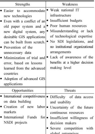
Table 3. SWOT factors
Strengths Weakness
• Easier to accommodate new technologies
• Even with a conflict of an old paper system and a new digital system, any desirable GIS applications can be built from scratch.
• Prevention of the unnecessary data
• Minimization of trial and error, based on lessons learned from the advanced countries
• Adoption of advanced GIS applications
• Weak national IT infrastructure
• Insufficient budgets
• Poor human resources
• Misunderstanding or lack of technological expertise
• No SDI legislations, and no institutional organizational arrangements
• Lack of awareness of the benefits at a higher decision making level
Opportunities Threats
• International competitiveness on data building
• Creation of new labor markets
• International Funds for NSDI projects
• Difficulty of data access and usability
• Uncertainty of the future continuous resources
• Insufficient willingness of decision makers
• Severe competition with global enterprises
Table 4. Critical Success Factors
Opportunities Threats Strengths S-O Strategies
• for building geospatial data and information using international funds and new technologies, focus on a product-based strategic model
S-T Strategies
• for establishing competitive geospatial platform providing discovery, access, sharing, and utilization of geospatial data, information and service.
Weakness W-O Strategies
• for capacity building by education of both GIS technological expertise and mind
W-T Strategies
• for cost-effective management with institutional, organizational arrangements for operational efficiency by promoting partnerships and cooperation (NIIS)
・ NGII(National Geographic Information Institute)
・ Statistical Geographic Information Service
・ Korea Forest GIS Service
・ Seoul Metropolitan City
・ Daegu Metropolitan City
4) What might be SWOT factors for developing countries?
• The factors and results of the SWOT analysis are summarized in 3.2 Analysis of SWOT.
5) How can SDI be built in developing countries efficiently?
• Establishing priorities and strategies for SDI in developing countries would be more important for success than implementing each NSDI component.
The NSDI action plan including core projects, driving forces and related budgets, legislations, and GIS education and capacity building, would be in a strategically higher position than the other components of SDI.
3.2 Analysis of SWOT
From the perspective of developing countries, SWOT Analysis can be useful to derive implementation strategies for the NSDI model later. From the interviews of GIS experts, the SWOT factors are identified for developing countries as follows (Table 3):
The SWOT matrix above could help draw strategic directions and identify tasks and activities for efficient NSDI implementation later.
Critical success factors, based on above SWOT analysis, the S-O strategy, S-T Strategy, S-T Strategy and S-T Strategy are identified as follows (Table 4):
3.3 Lessons Learned
Based on the previous results of the interview and SWOT analysis, the Korean NSDI lessons can be summarized in terms of six components mentioned.
3.3.1 Data
It is important to have a harmonized concept for spatial data quality in different communities such as
surveying and GIS. From the surveyors’ perspective,
accuracy is most important for data production, but
GIS users can have a quite different requirement for various usages and applications. Bridging the gap between formal institutional data quality and informal quality for business is important. For example, using digital ortho-photo or satellite image or new efficient measurement technologies are more recommended for the beginners of NSDI than highly accurate, expensive topographic maps by traditional surveying methods.
Data updating should be considered at the beginning of building data to prevent duplicated investment later.
For rapid return on investment, selection of map at the proper scale and early decision on the data building method are to be considered.
3.3.2 Standard
Standards should necessarily be considered from the beginning of the NSDI implementation. Two hierarchical standards have been developed for the Korean NSDI:
KS(Korean Standards) as a national standard and TTA(Telecommunications Technology Association) standard as an organizational one. Vertically consistent standard management is important and profiling from a higher level of standard is a recommended method.
Many NSDI projects have been implemented without knowing the importance of the standards at the beginning and can raise the issue of interoperability and integration in the NSDI projects later.
3.3.3 Access & Metadata
Online and offline data distribution network are both necessary for successful SDI. Geospatial One Stop Portal for access service and linkage with e-government portal is a useful component of NSDI.
For data sharing and distribution through the Portal, metadata and data catalogue are required.
The use of geospatial web technologies with VGI (Volunteered Geographic Information) concept can extend collection and access of spatial data and enrich user communities [3][5].
3.3.4 Technology
Even with development of GIS technologies through the 3 phases, the Korean NSDI could not replace adoption of imported foreign technologies as much as expected. Ubiquitous technologies in Korea could have
had the competitiveness to attack a niche market but those could not ne used for real applications. It might be plausible to have our own technologies for the NSDI implementation but that is not sometimes a practical approach, especially at the beginning stage of the NSDI. Wider use of open source technologies is recommended for future GIS applications.
Therefore, developing new geospatial technologies is less recommended for developing countries.
3.3.5 Human resources, and law/institution Because government officials have less GIS expertise and experiences, the direction of NSDI can be inconsistent. GIS experts need to be in a geospatial policy-making level such as a GIO (Geographic Information Officer) in the USA.
Competitions between GIS and surveying community can cause unhealthy NSDI development. Usually surveyor’s law has been more substantial and applicable to existing businesses than geospatial information laws and regulations in reality. Accuracy has prevailed over fitness for use. Accurate data production takes much longer than expected for GIS applications and NSDI development.
In the three-phase NSDI master plan, each phase proposed different visions. The vision needs to be consistent as long as the plan goes.
Practical regulations for local governments are required for NSDI. A clear role definition of the central and local governments is critical.
Evaluation of the NSDI components is mandatory for the next phase master plan.
3.3.6 Partnership
Strong government leadership and organizational
partnership are important. Due to lack of organizational
collaboration, an important decision for NSDI standards
requiring consensus from many organizations, for
example, can be delayed. To keep a more powerful
organizational partnership, stronger reorganization
efforts of driving forces and practical regulations are
required but it is usually not accomplished. For
example, a chairperson of “National Spatial Data
Committee” would be the President, who can provide
more powerful leadership than the MOLIT (Ministry
of Land, Infrastructure, and Transport) in Korea. A more powerful leadership enables increase of cooperations and collaborations with other governmental organizations and agencies.
4. A Strategic NSDI Model for Developing Countries
The strategic NSDI Model consists of implementation strategies, roadmap of NSDI tasks and activities, and harmonized NSDI approach.
4.1 Implementation Strategies for Developing Countries
Based on the previous critical success factors, strategies are suggested in terms of geospatial data, capacity building, geospatial platforms, and cost-effective management with partnership. Those strategies can be applied at a national and a local level.
Given various political, economic and cultural circumstances in developing countries, findings of this study can have different implications for different countries. However, the first top priority might be given to the efficient creation of geospatial data.
4.1.1 Strategies for geospatial data
Digital topographic maps at 1/1,000 scale covering most of the cities and at 1/5,000 for the entire country have greatly contributed as a high-quality basemap to the Korean NSDI. Building the digital topographic map database is, however, an expensive task covering a relatively long period of time [16]. Considering current technologies for data collection, strategies for geospatial data for developing countries can be different from the Korean experience. For example, Openstreetmap is way ahead a wiki-style VGI map using various mapping technologies including remote mapping and sketching over aerial imagery with GPS unit [7]. It can be an economical way to build a base map quickly without encountering the delays inevitably associated with the conventional base map creation.
In addition, Korean experiences with various NSDI projects, building and maintaining geospatial data are evenly important for sharing and using data later. In
this context, it is required to make the data more interoperable for later use. Thus, to build and share geospatial data, information and service efficiently, standardization is a prerequisite for a successful NSDI.
In regards of the issue of budget constraint, the co-funding partnership in building national topographic maps by central and local governments in Korea is a good practice for developing countries.
4.1.2 Strategies for capacity building
Because of poor human resources in developing countries, strategies for capacity building are another high priority. SDIs seem to be most successful when the use of local and national geographic information assets is maximized. Capacity should necessarily be built in person to maximize SDI potentials. This is particularly important in developing countries where the implementation of SDI initiatives is often dependent on a limited number of staff with necessary geographic information management skills. It must also be recognized that capacity building (including GIS education) is needed more at a local level than at a central one because central government officials tend to be more administrative and local ones need to be more technical and skillful for their works.
4.1.3 Strategies for geospatial platforms
Without enabling access platforms and appropriate metadata services to find useful information, it is unlikely that a SDI will be able to achieve its overarching objective of promoting greater use of geographic information. There is also a practical reason the development of metadata services should be given a high priority in the implementation of a SDI: they can be developed relatively quickly and inexpensively.
In this respect those can be regarded as a potential quick winner which demonstrates tangible benefits for the participants in SDI development. In recent years the development of geospatial portals has opened up new possibilities for metadata and application services.
As its name suggests, geospatial portals can be seen as gateways to geographic information resources.
These portals also allow users and providers to share
the contents and create a consensus.
Table 5. A roadmap for tasks and activities at a national level
Strategies SDI
components The 1st phase The 2nd phase The 3rd phase
Strategies for geospatial data
Technology Arrangements of National Geodetic controls Data Building of
fundamental spatial data and topological map
Topography, boundaries of roads/railways,
etc.
Cadastral Administrative
boundaries
Facilities, structures
Hydro-graphy, boundaries of
rivers Updating and
Management of topological map Standard Standard for
digital topological map
Standard for fundamental
spatial data Strategies for
GI capacity building
Human resource
Project for GIS capacity building
Offline GIS expert education
On-line GIS education Strategies for
cost-effective management of
GI with partnership
Law/Institution NSDI* Plan for the 1st phase
NSDI Plan for the 2nd phase
NSDI Plan for the 3rd phase GIS legislation
and institutional arrangements Strategies for
GI portal enabling
access platforms
Access and metadata
Pilot project for National spatial clearing house
National spatial clearing house
GIS portal for public access
Standard Developments of
standards for exchange of spatial data
Development of GIS metadata
standard
*NSDI: National Spatial Data Infrastructure
4.1.4 Strategies for cost-effective management with strong leadership and partnership
As seen in the Korean NSDI, a strong national NSDI leadership by the central government is a strategically important drive for successful SDI implementation at the beginning. This topdown approach is also needed for SDI in developing countries. “National Spatial Data
Committee” in Korea played a critical role as an interagency committee, in coordinating matters concerning national spatial data policy to promote the coordinated development, use, sharing and dissemination of geospatial data and services.
Legislations for the NSDI at a national and
regulations at a local level also are required for an
efficient partnership [8].
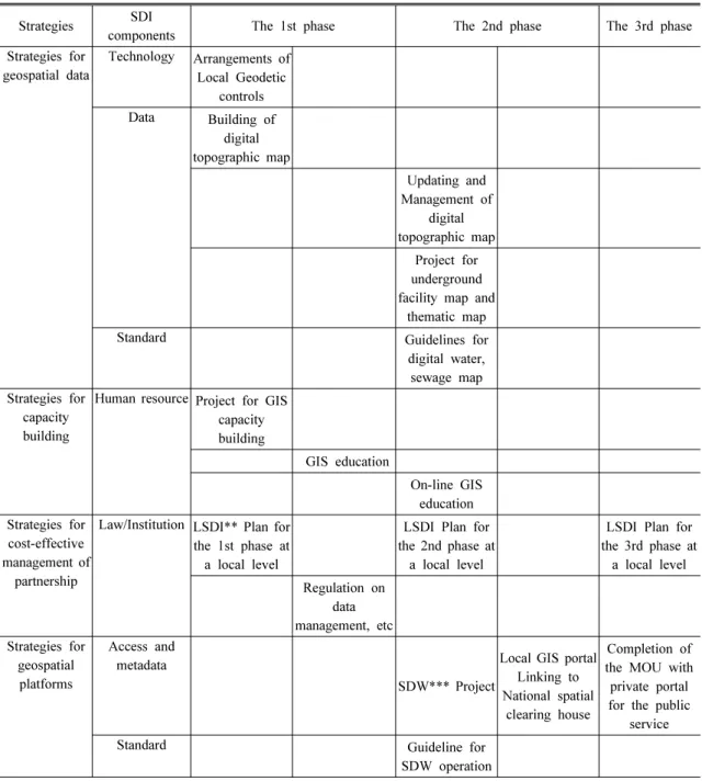
Table 6. A roadmap for tasks and activities at a local level
Strategies SDI
components The 1st phase The 2nd phase The 3rd phase
Strategies for geospatial data
Technology Arrangements of Local Geodetic
controls Data Building of
digital topographic map
Updating and Management of
digital topographic map
Project for underground facility map and
thematic map
Standard Guidelines for
digital water, sewage map Strategies for
capacity building
Human resource Project for GIS capacity building
GIS education
On-line GIS education Strategies for
cost-effective management of
partnership
Law/Institution LSDI** Plan for the 1st phase at
a local level
LSDI Plan for the 2nd phase at
a local level
LSDI Plan for the 3rd phase at
a local level Regulation on
data management, etc Strategies for
geospatial platforms
Access and metadata
SDW*** Project
Local GIS portal Linking to National spatial
clearing house
Completion of the MOU with
private portal for the public
service
Standard Guideline for
SDW operation
**LSDI: Local Spatia Data Infrastructure, ***SDW: Spatial Data Warehouse
4.2 Roadmap of Important NSDI Tasks and Activities
As mentioned before, SDI evolves and has its own history. Based on the lessons learned, it is possible to extract important tasks and activities for successful NSDI implementation. For the strategic model, SDI
tasks and activities for developing countries should be
prioritized in terms of trials and errors in the Korean
NSDI history and lessons learned, and can be presented
on a roadmap. The roadmap has two dimensions: six
NSDI components and three phases of NSDI to display
the SDI tasks and activities. Two different kinds of
Figure 4. Harmonization model of SDI - a strategic SDI model for developing countries
roadmaps are presented for a national(NSDI) and a local(LSDI, Local Spatial Data Infrastructure) level(see Table 5, and 6). Although situations and environments are different in developing countries, the roadmap for SDI tasks and activities would be a good reference for
“what and when to do”. The two tables do not have an exhaustive list of tasks and activities but those can be milestones for developing countries.
4.3 Harmonized Approach for NSDI Implementation
At the beginning stage of NSDI, the topdown approach plays a more critical role than a bottom-up approach useful in the later stage of NSDI. Both approaches should be integrated in harmony as time goes on. As seen in Figure 3. SDI hierarchy, local SDIs are actual implementations of NSDI and the sum of those draws an overall picture of NSDI. “Planning globally and implementing locally” requires a balanced approach for the hierarchies.
In this context, as a strategic NSDI model for developing countries, a harmonization model of top- down and bottom-up approach can provide a good solution eventually (Figure 4).
Reflecting a new paradigm shift from a traditional GIS to cloud-based geospatial apps, more bottom-up approach is needed for the future.
5. Conclusion
This study suggests a strategic NSDI model for developing countries based on the Republic of Korea’s lessons. As far as administrative barriers between the public organizations exist, trials and errors are likely to happen all the time. Hopefully, this model can help reduce any mistakes in the future NSDI
implementation.
As a conclusion for developing countries, four points are chosen to exemplify Korean experiences as follows:
(1) data harmonization and integration, (2) standards harmonization for data, access platforms and technology, (3) public-private partnership, and (4) legal/institutional/
organizational policy arrangements.
Firstly, master and action plans for the two different levels (national and local) and implementing phases should be harmonized to prioritize the tasks and activities such as data building, sharing, dissemination and utilization. For the SDI in developing countries, strategies mentioned for geospatial data, and activities based data harmonization and integration would be a top priority.
Secondly, it might be important to achieve standard harmonization across hierarchical levels of SDI in developing countries. For example, based on a standardized topographic dataset at a national level, guidelines for water and sewage map at a local level can be developed.
Additional guidelines for data harmonization and integration, access platforms and technologies can be other important tasks to be done.
Third, in regards to the public-private partnership, capacity building driven by the partnership can be a good practice. Concept of three Cs(Cooperation, Communication, Coordination) has to be emphasized for wider range of partnerships.
Lastly, legal/institutional/organizational policy arran-
gements should be considered for the harmonization
model in Figure 4. Wider participation of SDI stake-
holders from the public and private sector, and from
a national and a local level, and cooperative organizations
such as “National Spatial Data Committee” in Korea,
or FGDC (Federal Geographic Data Committee) in the
USA can play an essential role. To realize NSDI
policies, laws and institutional regulations should be
established and would be helpful for budget struggle and to keep consistency.
Above all, a strong leadership, a broad and deep perspective, and never-fading passion in driving forces are fundamental elements for the successful NSDI implementation in developing countries.
References
[1] Choi, B. M; et al. 2009 Establishment of Korean Spatial Data Infrastructure Model and Study of Globalization Strategy, KRIHS.
[2] Coleman, D. J; McLaughlin, J. 1998, Defining global geospatial data infrastructure (GGDI):
components, stakeholders and interfaces, Goematica, 52(2):129-144.
[3] Goodchild, M. F. 2007, Citizens as sensors: the world of volunteered geography, NCGIA VGI Workshop.
[4] http://en.wikipedia.org/
[5] http://nationalmap.gov/TheNationalMapCorps/
[6] http://www.fgdc.gov
[7] http://www.openstreetmap.org
[8] Kim, E. H. 2005, Comparative Study on Advanced NSDIs for the future NSDI Implementation in Korea, The journal of geographic information system association of Korea, 13(4):381-391.
[9] Kim, E. H. 2008, The Prescriptive NSDI Model, The journal of geographic information system association of Korea, 16(4):499-511.
[10] KRIHS. 2007, Strategies of NSDI in Preparation for Paradigm Shift in Geospatial Information.
[11] Loenen, B. van; et al(ed). 2009, SDI Convergence:
Research, Emerging Trends, and Critical Assessment, NCG Nederlandse Commissie voor Geodesie Netherlands Geodetic Commission.
[12] Masser, I. 1998, The first generation of national geographic information strategies, in Proceedings of Selected Conference Papers of the Third Global Spatial Data Infrastructure Conference, Canberra, Australia.
[13] Masser, I. 2005, GIS Worlds: creating spatial data infrastructures, Redlands: ESRI Press
[14] MLTM. 2010, The 4th-phase National GIS Comprehensive implementation plan.
[15] Nebert, D. D. 2004, Global Spatial Data Infrastructure Association Cookbook http://www.gsdi.org/gsdi cookbookGSDI.
[16] NGII. 2010, Study on digital topological map at 1:2500 scale.
[17] Rajabifard, A; Feeney, M. E; Williamson, I. P.
2002, Directions for the Future of SDI Development, International Journal of Applied Earth Observation and Geoinformation, 4(1)11-22.
[18] Rajabifard, A; et al. 2002, Developing Spatial Data Infrastructures: From concept to reality.
논문접수:2013.10.16 수 정 일:2013.11.27 심사완료:2013.12.03
![Figure 2. SDI hierarchy[18]](https://thumb-ap.123doks.com/thumbv2/123dokinfo/5119942.333201/3.799.102.363.365.793/figure-sdi-hierarchy.webp)
![Table 1. Evolutionary characteristics in the 4th Phase the Korean NSDI (Source: MLTM, 2010)[14]](https://thumb-ap.123doks.com/thumbv2/123dokinfo/5119942.333201/4.799.79.386.138.326/table-evolutionary-characteristics-phase-korean-nsdi-source-mltm.webp)