건설 현장의 초정밀 디지털 맵 생성 및 연계를 위한 정보체계 프로토타입 설계
Design of an Information System Prototype for Generating and Linking Ultra-precision Digital Maps of Construction Sites
김종협
1
, 염동준2*
, 고현아3
, 강태경4
Jong-Hyeop Kim
1, Dong-Jun Yeom
2*, Hyun-A Ko
3, Tai-Kyung Kang
4<Abstract>
By nature, smart construction technology is a convergence technology, therefore aptly constructing and running an information system is needed in order to effectively develop and maintain it. Thus, in this study, an information system prototype was developed for the creation and linking of high precision digital maps at road construction sites for the effective performance of the development of the Information Collecting and Analyzing Techniques in the Construction Site (ICAT). For this, (1) defined input/output (I/O) data of each technical detail of ICAT, (2) analyzed the data flow, (3 ) proposed an information system prototype for high precision digital maps development and connection. Based on the information system prototype constructed in this study, it was inferred that each technique and its information for the Smart Construction Technique Development Business was in a consistent flow. Developed information system prototype would enable effective cooperation between subjects directly involved in the technique development, by defining I/O data in advance.
Moreover, it would be of value to practitioners for refining the output data from each technique, thereby linking databases and forming Entity Relationship Diagram.
Keywords : Digital Map, Information System, Construction Site, Smart Construction, Data Link
1 정회원, 주저자, 한국건설기술연구원, 건설정책연구소, 수석연구원/공학박사
2* 정회원, 교신저자, 한국건설기술연구원, 건설정책연구소, 박사후연구원/공학박사
E-mail: [email protected]
3 정회원, 공동저자, 한국건설기술연구원, 건설정책연구소, 전임연구원
4 정회원, 공동저자, 한국건설기술연구원, 건설정책연구소, 선임연구위원/공학박사
1 Construction Policy Institute, Korea Institute of Civil Engineering and Building Technology
2* Construction Policy Institute, Korea Institute of Civil Engineering and Building Technology
3 Construction Policy Institute, Korea Institute of Civil Engineering and Building Technology
4 Construction Policy Institute, Korea Institute of Civil
Engineering and Building Technology
1. 서 론
국토교통부의 ‘스마트 건설 기술 로드맵’ 수립 [1]에 따라 국내 건설분야 연구 및 산업계에서는 스마트 기술 기반의 업무 변화가 큰 이슈로 떠 오르고 있다. 스마트 건설은 “전통적인 건설에 스마트 건설 기술을 접목⋅활용하여 건설 생산 성 또는 안전성을 획기적으로 향상시키는 건설 방식[2]”으로, 건설 전(全)단계에 적용이 가능하 다. 특히, ‘시공 단계’에서는 건설장비 자동화, 조립시공 제어 등의 기술 개발이 활발히 이루어 지고 있어, 이를 지원하기 위한 3D 디지털 맵 기반의 현장 관측 및 모니터링 기술의 개발이 요구되고 있다[3].
이에 국토교통부에서는 2020년부터 도로분야 건설사업에 적용할 수 있는 스마트 건설 기술을 개발하기 위해, ‘스마트건설기술개발사업’을 추진 중에 있다. 이 과제는 건설장비 자동화 및 관제기 술, 도로 구조물 스마트 건설 기술, 스마트 안전 통합 관제기술, 스마트 건설 디지털 플랫폼 등을 개발하는 것을 목표로 한다. 이를 위한 세부 목표 중, ‘건설현장 정보 수집 및 분석 기술 개발’은 도 로공사 현장의 초정밀 디지털 맵을 주기적으로 생 성할 수 있는 기술을 개발하고, 이를 CPS(Cyber Physical System)로 구현 및 분석하여 활용할 수 있는 기술이다.
한편, 이러한 스마트 건설 기술은 태생적으로 융⋅복합 기술의 성격을 지니고 있다. 따라서 스 마트 건설 기술의 효과적 개발 및 관리를 위해서 는 다양한 정보를 효율적으로 결합, 운영하여 통 합된 기능을 발휘할 수 있도록 하는 적합한 정보 체계의 구축 및 운영이 필요하다[4].
따라서 본 연구에서는 건설현장 정보 수집 및 분석 기술 개발의 효과적 수행을 위한 도로공사 현장의 초정밀 디지털 맵 생성 및 연계를 위한 정
보체계 프로토타입을 설계하고자 한다. 이를 위해 건설현장 정보 수집 및 분석 기술의 (1) 세부 기 술별 I/O(Input/Output) 데이터를 정의하고, (2) 데이터 흐름을 분석한 후, (3) 초정밀 디지털 맵 생성 및 연계를 위한 정보체계 프로토타입을 제시 하고자 한다.
2. 이론적 고찰
2.1 스마트 건설
스마트 건설 기술은 전통적인 건축, 토목 기술 에 드론, 로봇, BIM(Building Information Model), IoT(Internet of Things), 빅데이터 등의 4차 산업 혁명 기술을 융합한 기술이다. 스마트 건설은 건 설 전 과정의 디지털화, 건설장비의 자동화, 현장 안전 관리 등을 통해 건설 생산성 향상 또는 안전 성 극대화를 목표로 한다[5]. 국내⋅외 건설산업 환경에서 이러한 스마트 기술 기반의 업무 변화가 큰 이슈로 대두되고 있으며, 스마트 건설 기술은 건설사업 전 단계에 정보통신기술, 드론, 로봇 등 다른 분야의 기술을 적극 도입하고 업무에 융합하 며, 3차원 시각 정보를 제공한다. 특히, ‘건설 시 공단계’에서는 장비 자동화, 조립시공 제어 등 기 술 개발 후 시공 전반을 자동화하기 위해 3차원 지형공간 정보 기반 현장 계측 및 모니터링 기술 이 반드시 필요하다.
한편, 대형 건설사업에서 모든 공종의 기반이
되는 토공사 및 포장공사는 여러 영역에서 동시다
발적으로 굴착, 운반 등 작업이 진행되므로 현장
여건의 변화가 매우 크며, 강우 및 기온 등 기상
조건에 따른 영향이 크므로 공사기간이 매우 엄격
히 관리되고 있다. 현장에서 지형 및 환경정보의
정확도는 토공량 산정 및 시공관리의 기초가 되 며, 지형정보를 얼마나 안전⋅신속⋅정확하게 취 득하는지가 공사 전 공정의 진척도와 생산성, 비 용절감의 시작이라고 할 수 있다. 또한, 작업계획 은 현황을 검토하여 공종에 투입되는 장비, 작업 자 간의 상호작용 및 정보 교환과 관련된 사항들 을 기록하게 되므로, 작업자 및 장비운용상의 안 전과 관련된 작업공간 현황정보 등 작업에 영향을 미치는 요인들이 실시간으로 수집⋅관리되어야만 적절한 계획이 이루어질 수 있다.
2.2 스마트건설기술개발사업
국토교통부에서는 국내 건설산업의 오랜 과제인 생산성, 안전성 문제를 스마트 건설 기술을 통해 해결하고, 건설산업의 디지털화 및 자동화를 위한 기술혁신 및 산업생태계 조성을 위해 ‘스마트건설 기술개발사업’을 추진하였다. 이 사업에서는’도로 분야 건설 全단계(설계-시공-유지관리)에 걸쳐 생 성되는 정보를 디지털화하고, 스마트 건설 디지털 플랫폼 네트워크로 연결하여 건설 생산성과 안전 성을 혁신적으로 개선’하는 것을 목적으로 하고 있다. 이 중 ‘건설현장 정보 수집 및 분석 기술 개발’은 토공 및 포장공사 현장의 통합 시공품질 관리를 위한 현장 시공데이터 실시간 관리를 가능 하게 하기 위해, 드론 및 지상 무빙플랫폼(UGV : unmanned ground vehicle, 이하 UGV)으로 취 득한 지형정보를 통합하여, 초정밀 디지털 맵을 생성하는 기술을 개발한다.
앞서 서술한 바와 같이, 스마트 건설 기술과 같 은 융⋅복합연구는 다양한 정보가 복합적으로 연 계되어 있기 때문에 연구개발 초기에 이러한 정보 를 효율적으로 결합, 운영할 수 있도록 계획하는 것이 매우 중요하다.
2.3 정보체계 관련 연구동향
정보체계는 다양한 자료와 정보를 적절히 가공 하여 자료화하고, 이들 자료를 보다 이용하기 쉽 도록 자료기반(DB; Database)으로 구축하고, 이를 바탕으로 하여, 일정한 목적에 부합하는 의미와 기능을 갖는 정보를 생산하여 이들 자료와 정보를 효율적으로 결합, 운영하여 통합된 기능을 발휘할 수 있도록 하는 체계이다[4]. 또한 외부환경과 경 계를 가지면서 정보기관 내에서 상호작용하는 요 소들로 구성된 집합체로 이해되고 있다[6].
정보체계는 컴퓨터에 의한 자료처리 시스템으로 부터 시작하여, 정보처리단계 및 전통적인 관리정 보체계단계를 거쳐, 오늘날의 폭넓은 관리정보체 계에 이르고 있다[7]. 국내에서의 정보체계와 관련 된 연구는 대부분 행정정보체계나 전자정부 구현 등에 초점을 맞춘 연구가 주를 이루고 있으며, 군 사, 농업, 지리, 경영 분야 등에서 활발하게 활용 되고 있다[8-10].
본 연구에서는 스마트 건설 기술의 효과적 개 발 및 관리를 위해 다양한 정보를 효율적으로 결 합, 운영하여 통합된 기능 발휘를 위한 방법으로 써 정보체계를 구축하고자 한다.
3. 방법론
본 장에서는 도로공사 현장의 초정밀 디지털
맵 생성 및 연계를 위한 정보체계 프로토타입 설
계를 위한 방법론을 설명한다. 본 연구에서 제시
하는 정보체계 프로토타입은 3단계의 절차를 통해
설계되었다. 첫째, 개발기술들에 대해 상세한 정의
를 하고 관련 I/O 정보들을 정리한다. 둘째, 개발
기술들 간의 데이터 흐름을 파악하고 이를 다이어
그램으로 표현한다. 셋째, 각 기술들의 데이터 흐 름과 I/O 정보를 총괄하는 정보체계를 설계한다.
4. 개발기술 및 요구사항 정의
본 장에서는 초정밀 디지털 맵 생성 및 연계 를 위한 정보체계 구축을 위해 스마트건설기술개 발사업에서 건설현장 정보 수집 및 분석을 위한 기술을 세부적으로 분석하고, 개발기술을 정의하 고, 각 개발기술을 구현하기 위한 I/O 정보를 정 의한다.
4.1 건설현장 정보 수집 및 분석 기술
스마트건설기술개발사업에서 건설현장 정보 수 집 및 분석을 위한 기술은 크게 두 부분으로 나누 어진다. 첫 번째는 드론과 UGV를 이용하여 초정 밀 디지털 맵을 생성하는 기술이다. 두 번째는 생 성된 초정밀 디지털 맵을 이용하여 CPS를 구성하 고 이를 작업계획에 활용할 수 있도록 하는 기술 이다.
두 가지 기술은 다시 각 3 개의 세부기술로 나 누어진다. 초정밀 디지털 맵 생성 기술은 드론을 활용한 측량기술, UGV를 활용한 측량기술, 이 두 정보를 정밀 정합하여 디지털 맵으로 전환하는 기 술로 이루어진다. 그리고 디지털 맵 기반의 CPS 를 이용한 작업계획 기술은 건설현장의 각종 정보 를 취득하여 빅데이터 분석을 실시하는 기술, 분 석결과를 건설 생산성과 안전성 분석에 반영하여 작업계획 시뮬레이션을 제공하는 기술, 그리고 이 를 AR/VR을 이용해 시각화하는 기술로 이루어진 다. 각 세부기술을 위해 개발하고자 하는 기술은 Table 1과 같다.
4.2 개발기술 간 정보처리 흐름
각 개발기술들은 초정밀 디지털 맵 생성 및 연 계를 위해 일련의 흐름을 가진 채 연결되어 있으 며, 이는 본 연구에서 제안하고자 하는 정보체계 설계에서 매우 중요한 부분을 차지한다. 따라서 이 장에서는 각 개발기술들 간의 업무흐름을 정의 한다.
스마트건설기술개발사업에서 건설현장 정보 수 집 및 분석을 위한 기술의 흐름은 드론과 UGV의 자율측량에서 시작한다. 우선 측량에 필요한 기술 을 탑재한 드론과 UGV가 각각 지형정보를 취득 하고 이를 초기 디지털 맵으로 생성한다. 그 후 그 정보를 통합하고 노이즈를 제거하여 초정밀 디 지털 맵을 생성하게 된다. 생성된 디지털 맵은 현 장에 설치된 센서에서 수집된 정보들과 함께 CPS 를 구성하고 이를 바탕으로 현장 작업 계획의 시 뮬레이션을 수행하도록 한다. 이러한 정보는 통합 플랫폼으로 모여 사용자에게 제공되며, CPS의 보 다 효과적인 시각화를 위해 AR/VR 기반의 기술 이 활용된다. 개발기술의 정보흐름을 도식화하면 Fig. 1과 같다.
4.3 개발기술 요구사항 및 I/O 데이터
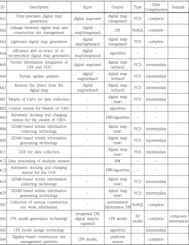
각 개발기술들은 서로 독립적이면서도 I/O 정 보에 있어 매우 밀접하게 연결되어 있다. 따라서 이 정보에 대한 세부적인 분석을 실시하여 정보체 계 구축을 수행하고자 한다. 다음의 Table 2는 각 개발기술 요구사항 및 I/O 데이터 등을 정리한 것이다.
개발기술의 요구사항을 정리하기 위해서 각 기
술 별 내용을 파악하고, 해당 기술을 수행하기 위
해 필요한 Input 데이터를 정의하고 기술을 통해
Configuration
technology Core technology Development technology
A
Ultra- precision
digital generation map technology
AA
Geoinformatio n integrated digital map generation technology
AA1 Ultra-precision digital map generation and utilization system AA2 3D terrain-based construction site information linkage module AA3 Lightened digital map generation technology
AA4 Automatic generation efficiency and accuracy analysis of ultra-precision digital map AA5 Precise integration of heterogeneous data
AA6 AI algorithm for terrain update
AA7Object recognition technology in digital map
AB
Swarm of un- manned aerial vehicles based
surveying system
AB1 UAVs for data acquisition of the construction site
AB2 An intelligent UAVs control system of the construction site AB3 Automatic docking and charging technology of UAVs AB4 Terrain surveying technology using UAVs-mounted LIDAR
AB5 LIDAR point cloud data-based 3D terrain information generation system
AC
Unmanned ground ve- hicles based surveying sys-
tem
AC1 UGV hardware suitable for the construction site
AC2 Data processing technology to respond to the construction environment AC3 Automatic docking and charging technology of UGVs
AC4 Integrated sensor system for digital map generation
AC5 Real-time location recognition and mapping technology of UGV
B
CPS-based constructio
n site informatio n analysis
and mapping technology
BA
Big data in- tegration and
information management
platform of the con- struction site
BA1 Environment information auto-collection and analysis technology of the construction site
BA2 Construction CPS generation technology BA3 Design and realization of digital map-based CPS BA4 Big data-based construction site management platform BA5 Construction CPS-based database design
BA6 Automatic recognition of construction worker status
BB
CPS simu- lation-based work planning
technology
BB1 Development of CPS-based construction site simulation technology BB2 Simulation technology of construction site information-based obstacle
detection for the safety
BB3 Development of construction site simulation-based work planning technology
BB4 Development of linkage technology between CPS and construction site management platform
BC
Visualization and sharing technology of the con- struction site
BC1 Digital map-based construction site information mapping
BC2 Business supporting technology that combines sensing information, simulation information, and digital map BC3 Work plan and scenarios-based Construction site information visualization BC4 lightened of visualization data
BC5 XR-based construction management system for earthworks
BC6 Linkage technology between information sharing technology and construction site management platform
Table 1. Detailed list of Information Collecting and Analyzing Techniques (ICAT)도출될 수 있는 Output 데이터를 예상하였다. 또 한 이 I/O 데이터들이 어떤 형태(예, Point Cloud Data, NoSQL or SQL DB 등)로 구성해야할 지를 사전에 정의하였다. 마지막으로 각 기술들을 통해 도출된 Output이 중간 처리과정인지, 최종 처리 결과인지를 정의하여, 추후 필요한 데이터베이스 정의에 활용할 수 있도록 하고자 했다.
5. 초정밀 디지털 맵 생성 및 연계를 위한 정보체계
앞서 4장에서는 건설현장 정보 수집 및 분석을 위한 기술의 개발기술을 분류하고 이에 대한 세부 적인 요구사항 및 I/O 데이터를 정의하였다. 이 장에서는 이를 통합하여 초정밀 디지털 맵 생성 및 연계를 위한 정보체계를 제시한다.
5.1 정보체계 개발방향
본 연구에서 정보체계는 순서도와 데이터 테이 블을 혼합하여 표현하고, 결과적으로 기술 간의 업무 흐름과, 데이터 간의 흐름을 동시에 보여줄 수 있는 방법을 이용하였다. 이를 위해, 다음 Fig.
2와 같이, 기술 간의 흐름을 실선으로 표현하고 각 기술의 I/O 데이터 흐름을 점선으로 표현하여 구분하였다.
Fig. 2 Concept of information system in this study Fig. 1 Information flow of ICAT
ID Description Input Output Type Data
Completeness Remark AA1 Ultra-precision digital map
generation digital map(raw) digital map
(integrated) PCD complete AA2 Linkage between digital map and
construction site management digital
map(integrated) DB NoSQL complete
AA3 Lightened digital map generation digital
map(lightened) digital map
(integrated) PCD complete AA4 efficiency and accuracy of ul-
tra-precision digital map generation digital
map(integrated) algorithm - -
AA5 Terrain information integration of
UAV and UGV digital map(raw) digital map
(refined) PCD intermediate AA6 Terrain update analysis digital
map(refined) digital map
(refined) PCD intermediate AA7 Remove the object from the
digital map digital
map(refined) digital map
(refined) PCD intermediate AB1 Swarm of UAVs for data collection - digital map
(raw) PCD intermediate
AB2 Control system for Swarm of UAVs - algorithm - -
AB3 Automatic docking and charging
station for the swarm of UAVs - HW/algorithm - -
AB4 LIDAR-based terrain information
collecting technology - digital map
(raw) PCD intermediate AB5 LIDAR-based terrain information
generating technology - digital map
(raw) PCD intermediate
AC1 UGV for data collection - digital map
(raw) PCD intermediate
AC2 Data processing of multiple sensors HW - -
AC3 Automatic docking and charging
station for the UGV - HW/algorithm - -
AC4 LIDAR-based terrain information
collecting technology - digital map
(raw) PCD intermediate AC5 LIDAR-based terrain information
generating technology - digital map
(raw) PCD intermediate BA1 Collection of various construction
site work information - environment
information DB NoSQL complete
BA2 CPS model generation technology integrated DB, digital map(in-
tegrated) CPS model 3D
model complete composite information
BA3 CPS model design technology - algorithm - intermediate
BA4 Bigdata-based construction site
management platform CPS model, platform
system - complete
Table 2. Definition of requirements and I/O for each Technique
ID Description Input Output Type Data
Completeness Remark
BA5 Precise integration technology of heterogeneous data
Environment infor- mation DB, Work
information DB integrated DB NoSQL complete BA6 Automatic recognition of labor
status - Labor
information DB NoSQL complete BB1 Productivity analysis CPS model Productivity
information NoSQL complete
BB2 Safety analysis CPS model Safety
information NoSQL complete
BB3 Simulation-based work plan Productivity and safety analysis
information
Site
information NoSQL complete composite information
BB4 CPS-platform linkage technology Construction site work information
DB algorithm - intermediate
BC1 mapping between the digital map and construction site CPS model, work
information algorithm - intermediate BC2 AR/VR/MR-based construction site support CPS model, work
information algorithm - intermediate
BC3 AR/VR/MR-based visualization CPS model, work information
visualization information (integrated)
XR
model complete composite information
BC4 lightened visualization data Visualization data visualization information
(lightened) XR
model complete composite information
BC5 Construction management system for earthworks Visualization
data(integrated) system - complete BC6 Linkage technology between
visualization data and platform algorithm - intermediate
5.2 정보체계 구축
앞서 정의된 스마트건설기술개발사업에서 건설 현장 정보 수집 및 분석을 위한 기술의 세부적 내 용, 기술 흐름, I/O 데이터 등을 통합하여 Fig. 3 과 같이 정보체계 프로토타입을 구축하였다.
5.3 정보체계 프로토타입 정보체계 분석 및 향후 연구
구축된 정보체계 프로토타입을 기반으로 스마트
건설기술개발사업에서 건설현장 정보 수집 및 분 석을 위한 기술의 흐름을 세부적으로 분석하고 수 정 및 보완할 수 있는 방안을 도출할 수 있을 것 으로 판단하였다.
Fig. 3을 기반으로 건설현장 정보 수집 및 분석 기술을 파악하면, 대체적으로 각 기술 및 정보가 일련의 흐름을 가지고 일관되게 흐르는 것을 알 수 있다.
본 연구에서 설계된 정보체계 프로토타입을 이
용하면 개발기술들의 I/O 데이터를 사전에 정의하
여 기술개발 주체들 간에 효과적인 협력이 가능할
것으로 기대한다. 그리고 완료된 Output 데이터
로 분류된 값들을 이용하여 데이터베이스 간 연계 및 ERD(Entity Relationship Modelling) 구성에도 적용할 수 있을 것이다. 따라서 본 연구에 참여한 연구진은 정보체계 프로토타입을 활용하여 데이터 베이스 설계, ERD 구축 등을 할 수 있는 방안에 대해 연구 중에 있다.
6. 결 론
국내 건설분야 연구 및 산업계에서는 스마트 기 술 기반의 업무 변화가 큰 이슈로 떠오르고 있다.
이러한 스마트 건설 기술은 태생적으로 융⋅복합 기술의 성격을 지니고 있기 때문에 효과적 개발 및 관리를 위해서는 정보체계를 적합하게 구축하
여 운영하는 것이 필요하다.
이에 본 연구에서는 건설현장 정보 수집 및 분 석 기술 개발의 효과적 수행을 위해, 도로공사 현 장의 초정밀 디지털 맵 생성 및 연계를 위한 정보 체계 프로토타입을 설계하였다. 이를 위해 건설현 장 정보 수집 및 분석 기술의 (1) 세부 기술별 I/O 데이터를 정의하고, (2) 데이터 흐름을 분석 한 후, (3) 초정밀 디지털 맵 생성 및 연계를 위 한 정보체계 프로토타입을 제시하였다.
본 연구에서 구축한 정보체계 프로토타입을 기 반으로 스마트건설기술개발사업에서 건설현장 정 보 수집 및 분석을 위한 기술의 흐름을 세부적으 로 분석하여, 각 기술 및 정보가 일련의 흐름을 가지고 일관되게 흐르는 것을 알 수 있었다.
설계된 정보체계 프로토타입을 통해 개발기술의
I/O 데이터를 사전에 정의하여 기술개발 주체들
Fig. 3 Information system prototype for generating and linking ultra-precision digital map간에 효과적인 협력이 가능할 것으로 기대된다.
그리고 완료된 Output 데이터로 분류된 값들을 이용하여 데이터베이스 간 연계 및 ERD 구성에도 적용할 수 있을 것으로 판단한다.
감사의 글
본 연구는 국토교통부/국토교통과학기술진흥원 의 지원으로 수행되었음(스마트건설기술개발사업:
20SMIP-A158708-01).
참고문헌