JPNT 3(1), 17-23 (2014)
http://dx.doi.org/10.11003/JPNT.2014.3.1.017
Copyright © The Korean GNSS Society http://www.gnss.or.kr plSSN: 2288-8187
J PNT Journal of Positioning, Navigation, and Timing
1. INTRODUCTION
Global Navigation Satellite System (GNSS), which is represented by the Global Positioning System (GPS) of the U.S., has been used in various areas of the modern society and has become an essential part of the global social infrastructure. However, in aircraft precision approach and landing, applying GNSS alone may not satisfy the high navigation performance and safety requirements. Therefore, Satellite Based Augmentation System (SBAS) was developed for such applications.
As the demand for airspace capacity, efficiency, and safety is increasing in the modern society, the need for navigation systems with higher performance and stability also grows. The operation of U.S. Wide Area Augmentation
Considerations on Ionospheric Correction and Integrity Algorithm for Korean SBAS
Eugene Bang, Jiyun Lee
†Division of Aerospace Engineering, Korea Advanced Institute of Science and Technology, Daejeon 305-701, Korea
ABSTRACT
Satellite Based Augmentation Systems (SBAS) provide ionospheric corrections at geographically five degree-spaced Ionospheric Grid Points (IGPs) and confidence bounds, called Grid Ionospheric Vertical Errors (GIVEs), on the error of those corrections. Since the ionosphere is one of the largest error sources which may threaten the safety of a single frequency Global Navigation Satellite System (GNSS) user, the ionospheric correction and integrity bound algorithm is essential for the development of SBAS. The current single frequency based SBAS, already deployed or being developed, implement the ionospheric correction and error bounding algorithm of the Wide Area Augmentation System (WAAS) developed for use in the United States. However, the ionospheric condition is different for each region and it could greatly degrade the performance of SBAS if its regional characteristics are not properly treated. Therefore, this paper discusses key factors that should be taken into consideration in the development of the ionospheric correction and integrity bound algorithm optimized for the Korean SBAS. The main elements of the conventional GIVE monitor algorithm are firstly reviewed. Then, this paper suggests several areas which should be investigated to improve the availability of the Korean SBAS by decreasing the GIVE value.
Keywords: grid ionospheric vertical error (GIVE), integrity, satellite based augmentation system (SBAS)
System (WAAS) was initiated in 2003, and other similar navigation systems are currently under test operation or development. These include: Multi-functional Satellite Augmentation System (MSAS) of Japan; European Geostationary Navigation Overlay Service (EGNOS) of the Europe; and GPS Aided GEO Augmented Navigation (GAGAN) of India. In Korea, Korean SBAS research and development project will be conducted from 2014. The first objective will be the development of a single frequency- based operation system with Approach Procedures with Vertical guidance (APV-I) capability and the final objective will be the realization of Category I experimental operation system by 2021.
The largest error source that may affect the accuracy of GNSS user positioning and threaten the safety of GNSS users comes from the ionosphere. Therefore, the SBAS allows the user to correct for the ionosphere induced error by providing ionospheric delay estimates at Ionospheric Grid Points (IGPs) and confidence bounds of the ionospheric delay estimates, called Grid Ionospheric Vertical Errors (GIVEs).
Received Jan 24, 2014 Revised Feb 06, 2014 Accepted Feb 17, 2014
†
Corresponding Author
E-mail: [email protected]
Tel: : +82-42-350-3725
18 JPNT 3(1), 17-23 (2014)
http://dx.doi.org/10.11003/JPNT.2014.3.1.017
The ionospheric correction procedure implemented in the existing SBAS is based on the GIVE monitor algorithm of the WAAS developed for use in the Conterminous United States (CONUS). However, South Korea is located at low geomagnetic latitude in comparison to the US CONUS region. Thus Korea is likely to be affected by equatorial anomaly (Saito & Fujii 2010) and plasma bubble (Maruyama et al. 2013) which frequently take place in the equatorial region. If an ionospheric correction and error bounding algorithm for the Korean SBAS is designed by assuming the same ionospheric activity in the CONUS region, it may difficult to realize the optimum performance. Furthermore, due to the limited number of reference stations and narrow distribution of reference stations in South Korea, if the conventional GIVE algorithm for WAAS is applied to the Korean SBAS without any modification, the optimum availability of the system may not be achieved.
Therefore, this paper discusses key components that should be taken into consideration for the development of the ionospheric correction and error bounding algorithm optimized for the Korean SBAS. The main elements of the conventional GIVE algorithm are firstly reviewed. Then, essential factors to be considered to improve the availability of the Korean SBAS are described. This paper includes following Sections: Section 2 explains the ionospheric delay estimation methods used in the conventional GIVE algorithm; Section 3 describes the GIVE value that is the integrity bound on the calculated ionospheric delay estimate; Section 4 describes an irregularity detector for detection of ionospheric irregularities which may occur under disturbed ionospheric conditions; and Section 5 summarizes the analysis and discussion in each Section, and suggests several factors that should be taken into account in the ionospheric correction and error bounding algorithm design for the Korean SBAS.
2. IONOSPHERIC DELAY ESTIMATION
This Section describes methods of estimating a vertical ionospheric delay at each IGP based on the ionospheric delay measurements at SBAS reference stations.
2.1 Planar Fit Estimation
In the standard planar fit algorithm, the ionosphere around an IGP is modeled under nominal ionospheric conditions as follows (Walter et al. 2000):
frequency-based operation system with Approach Procedures with Vertical guidance (APV-I) capability and the final objective will be the realization of Category I experimental operation system by 2021.
The largest error source that may affect the accuracy of GNSS user positioning and threaten the safety of GNSS users comes from the ionosphere. Therefore, the SBAS allows the user to correct for the ionosphere induced error by providing ionospheric delay estimates at Ionospheric Grid Points (IGPs) and confidence bounds of the ionospheric delay estimates, called Grid Ionospheric Vertical Errors (GIVEs).
The ionospheric correction procedure implemented in the existing SBAS is based on the GIVE monitor algorithm of the WAAS developed for use in the Conterminous United States (CONUS).
However, South Korea is located at low geomagnetic latitude in comparison to the US CONUS region.
Thus Korea is likely to be affected by equatorial anomaly (Saito & Fujii 2010) and plasma bubble (Maruyama et al. 2013) which frequently take place in the equatorial region. If an ionospheric correction and error bounding algorithm for the Korean SBAS is designed by assuming the same ionospheric activity in the CONUS region, it may difficult to realize the optimum performance. Furthermore, due to the limited number of reference stations and narrow distribution of reference stations in South Korea, if the conventional GIVE algorithm for WAAS is applied to the Korean SBAS without any modification, the optimum availability of the system may not be achieved.
Therefore, this paper discusses key components that should be taken into consideration for the development of the ionospheric correction and error bounding algorithm optimized for the Korean SBAS.
The main elements of the conventional GIVE algorithm are firstly reviewed. Then, essential factors to be considered to improve the availability of the Korean SBAS are described. This paper includes following Sections: Section 2 explains the ionospheric delay estimation methods used in the conventional GIVE algorithm; Section 3 describes the GIVE value that is the integrity bound on the calculated ionospheric delay estimate; Section 4 describes an irregularity detector for detection of ionospheric irregularities which may occur under disturbed ionospheric conditions; and Section 5 summarizes the analysis and discussion in each Section, and suggests several factors that should be taken into account in the ionospheric correction and error bounding algorithm design for the Korean SBAS.
2. IONOSPHERIC DELAY ESTIMATION
This Section describes methods of estimating a vertical ionospheric delay at each IGP based on the ionospheric delay measurements at SBAS reference stations.
2.1 Planar Fit Estimation
In the standard planar fit algorithm, the ionosphere around an IGP is modeled under nominal ionospheric conditions as follows (Walter et al. 2000):
I ˆ
v( , ) x y a ˆ
0 a x a y ˆ
1ˆ
2(1)
In Eq. (1), x and
ydenote the relative coordinates of an ionospheric pierce point (IPP) around the IGP. The origin of the relative coordinates is the position of the IGP. The planar model coefficients, (
a a aˆ0, ,
ˆ ˆ1 2), are estimated through the least square fit performed based on the vertical ionospheric delay measurements at IPPs around the IGP. The vertical ionospheric delay estimate at the IGP is given as follows (Walter et al. 2000):
I ˆ
v IGP, a ˆ
0(2)
In Eq. (1),
safety of GNSS users comes from the ionosphere. Therefore, the SBAS allows the user to correct for the ionosphere induced error by providing ionospheric delay estimates at Ionospheric Grid Points (IGPs) and confidence bounds of the ionospheric delay estimates, called Grid Ionospheric Vertical Errors (GIVEs).
The ionospheric correction procedure implemented in the existing SBAS is based on the GIVE monitor algorithm of the WAAS developed for use in the Conterminous United States (CONUS).
However, South Korea is located at low geomagnetic latitude in comparison to the US CONUS region.
Thus Korea is likely to be affected by equatorial anomaly (Saito & Fujii 2010) and plasma bubble (Maruyama et al. 2013) which frequently take place in the equatorial region. If an ionospheric correction and error bounding algorithm for the Korean SBAS is designed by assuming the same ionospheric activity in the CONUS region, it may difficult to realize the optimum performance. Furthermore, due to the limited number of reference stations and narrow distribution of reference stations in South Korea, if the conventional GIVE algorithm for WAAS is applied to the Korean SBAS without any modification, the optimum availability of the system may not be achieved.
Therefore, this paper discusses key components that should be taken into consideration for the development of the ionospheric correction and error bounding algorithm optimized for the Korean SBAS.
The main elements of the conventional GIVE algorithm are firstly reviewed. Then, essential factors to be considered to improve the availability of the Korean SBAS are described. This paper includes following Sections: Section 2 explains the ionospheric delay estimation methods used in the conventional GIVE algorithm; Section 3 describes the GIVE value that is the integrity bound on the calculated ionospheric delay estimate; Section 4 describes an irregularity detector for detection of ionospheric irregularities which may occur under disturbed ionospheric conditions; and Section 5 summarizes the analysis and discussion in each Section, and suggests several factors that should be taken into account in the ionospheric correction and error bounding algorithm design for the Korean SBAS.
2. IONOSPHERIC DELAY ESTIMATION
This Section describes methods of estimating a vertical ionospheric delay at each IGP based on the ionospheric delay measurements at SBAS reference stations.
2.1 Planar Fit Estimation
In the standard planar fit algorithm, the ionosphere around an IGP is modeled under nominal ionospheric conditions as follows (Walter et al. 2000):
I ˆ
v( , ) x y a ˆ
0 a x a y ˆ
1ˆ
2(1)
In Eq. (1), x and
ydenote the relative coordinates of an ionospheric pierce point (IPP) around the IGP. The origin of the relative coordinates is the position of the IGP. The planar model coefficients, (
a a aˆ0, ,
ˆ ˆ1 2), are estimated through the least square fit performed based on the vertical ionospheric delay measurements at IPPs around the IGP. The vertical ionospheric delay estimate at the IGP is given as follows (Walter et al. 2000):
I ˆ
v IGP, a ˆ
0(2)
and
safety of GNSS users comes from the ionosphere. Therefore, the SBAS allows the user to correct for the ionosphere induced error by providing ionospheric delay estimates at Ionospheric Grid Points (IGPs) and confidence bounds of the ionospheric delay estimates, called Grid Ionospheric Vertical Errors (GIVEs).
The ionospheric correction procedure implemented in the existing SBAS is based on the GIVE monitor algorithm of the WAAS developed for use in the Conterminous United States (CONUS).
However, South Korea is located at low geomagnetic latitude in comparison to the US CONUS region.
Thus Korea is likely to be affected by equatorial anomaly (Saito & Fujii 2010) and plasma bubble (Maruyama et al. 2013) which frequently take place in the equatorial region. If an ionospheric correction and error bounding algorithm for the Korean SBAS is designed by assuming the same ionospheric activity in the CONUS region, it may difficult to realize the optimum performance. Furthermore, due to the limited number of reference stations and narrow distribution of reference stations in South Korea, if the conventional GIVE algorithm for WAAS is applied to the Korean SBAS without any modification, the optimum availability of the system may not be achieved.
Therefore, this paper discusses key components that should be taken into consideration for the development of the ionospheric correction and error bounding algorithm optimized for the Korean SBAS.
The main elements of the conventional GIVE algorithm are firstly reviewed. Then, essential factors to be considered to improve the availability of the Korean SBAS are described. This paper includes following Sections: Section 2 explains the ionospheric delay estimation methods used in the conventional GIVE algorithm; Section 3 describes the GIVE value that is the integrity bound on the calculated ionospheric delay estimate; Section 4 describes an irregularity detector for detection of ionospheric irregularities which may occur under disturbed ionospheric conditions; and Section 5 summarizes the analysis and discussion in each Section, and suggests several factors that should be taken into account in the ionospheric correction and error bounding algorithm design for the Korean SBAS.
2. IONOSPHERIC DELAY ESTIMATION
This Section describes methods of estimating a vertical ionospheric delay at each IGP based on the ionospheric delay measurements at SBAS reference stations.
2.1 Planar Fit Estimation
In the standard planar fit algorithm, the ionosphere around an IGP is modeled under nominal ionospheric conditions as follows (Walter et al. 2000):
I ˆ
v( , ) x y a ˆ
0 a x a y ˆ
1ˆ
2(1)
In Eq. (1), x and
ydenote the relative coordinates of an ionospheric pierce point (IPP) around the IGP. The origin of the relative coordinates is the position of the IGP. The planar model coefficients, (
a a aˆ0, ,
ˆ ˆ1 2), are estimated through the least square fit performed based on the vertical ionospheric delay measurements at IPPs around the IGP. The vertical ionospheric delay estimate at the IGP is given as follows (Walter et al. 2000):
I ˆ
v IGP, a ˆ
0(2)
denote the relative coordinates of an ionospheric pierce point (IPP) around the IGP. The origin of the relative coordinates is the position of the IGP. The planar model coefficients,
and the final objective will be the realization of Category I experimental operation system by 2021.
The largest error source that may affect the accuracy of GNSS user positioning and threaten the safety of GNSS users comes from the ionosphere. Therefore, the SBAS allows the user to correct for the ionosphere induced error by providing ionospheric delay estimates at Ionospheric Grid Points (IGPs) and confidence bounds of the ionospheric delay estimates, called Grid Ionospheric Vertical Errors (GIVEs).
The ionospheric correction procedure implemented in the existing SBAS is based on the GIVE monitor algorithm of the WAAS developed for use in the Conterminous United States (CONUS).
However, South Korea is located at low geomagnetic latitude in comparison to the US CONUS region.
Thus Korea is likely to be affected by equatorial anomaly (Saito & Fujii 2010) and plasma bubble (Maruyama et al. 2013) which frequently take place in the equatorial region. If an ionospheric correction and error bounding algorithm for the Korean SBAS is designed by assuming the same ionospheric activity in the CONUS region, it may difficult to realize the optimum performance. Furthermore, due to the limited number of reference stations and narrow distribution of reference stations in South Korea, if the conventional GIVE algorithm for WAAS is applied to the Korean SBAS without any modification, the optimum availability of the system may not be achieved.
Therefore, this paper discusses key components that should be taken into consideration for the development of the ionospheric correction and error bounding algorithm optimized for the Korean SBAS.
The main elements of the conventional GIVE algorithm are firstly reviewed. Then, essential factors to be considered to improve the availability of the Korean SBAS are described. This paper includes following Sections: Section 2 explains the ionospheric delay estimation methods used in the conventional GIVE algorithm; Section 3 describes the GIVE value that is the integrity bound on the calculated ionospheric delay estimate; Section 4 describes an irregularity detector for detection of ionospheric irregularities which may occur under disturbed ionospheric conditions; and Section 5 summarizes the analysis and discussion in each Section, and suggests several factors that should be taken into account in the ionospheric correction and error bounding algorithm design for the Korean SBAS.
2. IONOSPHERIC DELAY ESTIMATION
This Section describes methods of estimating a vertical ionospheric delay at each IGP based on the ionospheric delay measurements at SBAS reference stations.
2.1 Planar Fit Estimation
In the standard planar fit algorithm, the ionosphere around an IGP is modeled under nominal ionospheric conditions as follows (Walter et al. 2000):
I ˆ
v( , ) x y a ˆ
0 a x a y ˆ
1ˆ
2(1)
In Eq. (1), x and
ydenote the relative coordinates of an ionospheric pierce point (IPP) around the IGP. The origin of the relative coordinates is the position of the IGP. The planar model coefficients, (
a a aˆ0, ,
ˆ ˆ1 2), are estimated through the least square fit performed based on the vertical ionospheric delay measurements at IPPs around the IGP. The vertical ionospheric delay estimate at the IGP is given as follows (Walter et al. 2000):
I ˆ
v IGP, a ˆ
0(2)
are estimated through the least square fit performed based on the vertical ionospheric delay measurements at IPPs around the IGP. The vertical ionospheric delay estimate at the IGP is given as follows (Walter et al. 2000):
frequency-based operation system with Approach Procedures with Vertical guidance (APV-I) capability and the final objective will be the realization of Category I experimental operation system by 2021.
The largest error source that may affect the accuracy of GNSS user positioning and threaten the safety of GNSS users comes from the ionosphere. Therefore, the SBAS allows the user to correct for the ionosphere induced error by providing ionospheric delay estimates at Ionospheric Grid Points (IGPs) and confidence bounds of the ionospheric delay estimates, called Grid Ionospheric Vertical Errors (GIVEs).
The ionospheric correction procedure implemented in the existing SBAS is based on the GIVE monitor algorithm of the WAAS developed for use in the Conterminous United States (CONUS).
However, South Korea is located at low geomagnetic latitude in comparison to the US CONUS region.
Thus Korea is likely to be affected by equatorial anomaly (Saito & Fujii 2010) and plasma bubble (Maruyama et al. 2013) which frequently take place in the equatorial region. If an ionospheric correction and error bounding algorithm for the Korean SBAS is designed by assuming the same ionospheric activity in the CONUS region, it may difficult to realize the optimum performance. Furthermore, due to the limited number of reference stations and narrow distribution of reference stations in South Korea, if the conventional GIVE algorithm for WAAS is applied to the Korean SBAS without any modification, the optimum availability of the system may not be achieved.
Therefore, this paper discusses key components that should be taken into consideration for the development of the ionospheric correction and error bounding algorithm optimized for the Korean SBAS.
The main elements of the conventional GIVE algorithm are firstly reviewed. Then, essential factors to be considered to improve the availability of the Korean SBAS are described. This paper includes following Sections: Section 2 explains the ionospheric delay estimation methods used in the conventional GIVE algorithm; Section 3 describes the GIVE value that is the integrity bound on the calculated ionospheric delay estimate; Section 4 describes an irregularity detector for detection of ionospheric irregularities which may occur under disturbed ionospheric conditions; and Section 5 summarizes the analysis and discussion in each Section, and suggests several factors that should be taken into account in the ionospheric correction and error bounding algorithm design for the Korean SBAS.
2. IONOSPHERIC DELAY ESTIMATION
This Section describes methods of estimating a vertical ionospheric delay at each IGP based on the ionospheric delay measurements at SBAS reference stations.
2.1 Planar Fit Estimation
In the standard planar fit algorithm, the ionosphere around an IGP is modeled under nominal ionospheric conditions as follows (Walter et al. 2000):
I ˆ
v( , ) x y a ˆ
0 a x a y ˆ
1ˆ
2(1)
In Eq. (1), x and
ydenote the relative coordinates of an ionospheric pierce point (IPP) around the IGP. The origin of the relative coordinates is the position of the IGP. The planar model coefficients, (
a a aˆ0, ,
ˆ ˆ1 2), are estimated through the least square fit performed based on the vertical ionospheric delay measurements at IPPs around the IGP. The vertical ionospheric delay estimate at the IGP is given as follows (Walter et al. 2000):
I ˆ
v IGP, a ˆ
0(2)
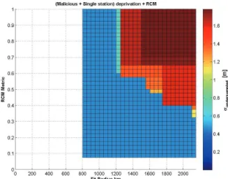
In the case of the WAAS, in order to obtain required performance, the minimum number and the maximum number of the ionospheric measurements to be used for the planar fit are limited to N
min=10 and N
max=30 (Pandya et al. 2007, Sparks et al. 2011a). In addition, the ionospheric measurements of the target number are searched within the predefined radius from the IGP. Currently, the minimum search radius and the maximum search radius of the planar fit are R
min=800 km and R
max=2100 km, respectively (Pandya et al. 2007, Sparks et al. 2011a).
2.2 Kriging Estimation
Kriging based methodology used to estimate the vertical ionospheric delay at IGPs was introduced in the WAAS Follow-On Release 3 to replace the planar fit (Sparks et al.
2011a, Blanch 2003). Kriging is a minimum mean square estimator that estimates characteristics at a point of concern on the basis of the weighted linear combination of the values at the nearby points of which characteristic values are known (Eq. (3)) (Sparks et al. 2011a). Blanch (2003) used ionospheric observables at SBAS reference stations as the known characteristic values.
In the case of the WAAS, in order to obtain required performance, the minimum number and the maximum number of the ionospheric measurements to be used for the planar fit are limited to N
min=10 and N
max=30 (Pandya et al. 2007; Sparks et al. 2011a). In addition, the ionospheric measurements of the target number are searched within the predefined radius from the IGP. Currently, the minimum search radius and the maximum search radius of the planar fit are R
min=800 km and Rmax=2100 km, respectively(Pandya et al. 2007; Sparks et al. 2011a).
2.2 Kriging Estimation
Kriging based methodology used to estimate the vertical ionospheric delay at IGPs was introduced in the WAAS Follow-On Release 3 to replace the planar fit (Sparks et al. 2011a; Blanch 2003). Kriging is a minimum mean square estimator that estimates characteristics at a point of concern on the basis of the weighted linear combination of the values at the nearby points of which characteristic values are known (Eq. (3)) (Sparks et al. 2011a). Blanch (2003) used ionospheric observables at SBAS reference stations as the known characteristic values.
1
ˆ ( )
vI ( )
N
k meas k k
I x w x
(3)
In equation (3),
xindicates the relative coordinate of each IPP whose origin is at each IGP, I
measdenotes the ionospheric delay measurement at each IPP, and w
kindicates the weight coefficient applied to each measurement. The weight coefficient, w
k, are determined primarily by the detrended ionospheric delay covariance between measurement locations (Sparks et al. 2011a). In particular, the detrended ionospheric delay covariance is calculated based on variogram (Cressie 1993). The variogram characterizes spatial structure of the nominal ionosphere (Sparks et al. 2011a; Blanch 2003). In the Kriging based estimation, constraints on the number of the ionospheric measurements and the search radius for measurements are the same with those of the planar fit algorithm described in Section 2.1.
Sparks (2011a) compared the root mean square (RMS) errors of the ionospheric delay obtained by the planar fit algorithm and the Kriging method during disturbed ionospheric conditions. Sparks (2011a) also reported that the performance of the Kriging-based estimation was better than that of the planar fit algorithm by up to 15%.
3. INTEGRITY BOUND ON THE IONOSPEHRIC CORRECTION
As mentioned earlier, SBAS provides not only the ionospheric delay estimates at IGPs but also GIVE values, the integrity bounds on the estimates. The GIVE value whose magnitude has major contribution to the magnitude of the protection level of the SBAS user is calculated based on the uncertainties associated with the fit plane, nominal ionospheric decorrelation, and undersampled threat model contributions (Pandya et al. 2007). Section 3 reviews each element of the GIVE value and discusses factors which should be taken into consideration in designing the ionospheric correction and error bounding algorithm of the Korean SBAS.
3.1 Formal Estimation Error
The formal estimation error term in the GIVE calculation is defined to consider the uncertainty inherent in the planar fitting procedure (Cormier et al. 2003). Under quiet ionospheric conditions, the planar fit estimation error can be sufficiently bounded by this formal error variance, and the GIVE value is computed based on the formal error variance (Sparks et al. 2011b).
In Eq. (3),
In the case of the WAAS, in order to obtain required performance, the minimum number and the maximum number of the ionospheric measurements to be used for the planar fit are limited to N
min=10 and N
max=30 (Pandya et al. 2007; Sparks et al. 2011a). In addition, the ionospheric measurements of the target number are searched within the predefined radius from the IGP. Currently, the minimum search radius and the maximum search radius of the planar fit are R
min=800 km and Rmax=2100 km, respectively(Pandya et al. 2007; Sparks et al. 2011a).
2.2 Kriging Estimation
Kriging based methodology used to estimate the vertical ionospheric delay at IGPs was introduced in the WAAS Follow-On Release 3 to replace the planar fit (Sparks et al. 2011a; Blanch 2003). Kriging is a minimum mean square estimator that estimates characteristics at a point of concern on the basis of the weighted linear combination of the values at the nearby points of which characteristic values are known (Eq. (3)) (Sparks et al. 2011a). Blanch (2003) used ionospheric observables at SBAS reference stations as the known characteristic values.
1
ˆ ( )
vI ( )
N
k meas k k
I x w x
(3)
In equation (3),
xindicates the relative coordinate of each IPP whose origin is at each IGP, I
measdenotes the ionospheric delay measurement at each IPP, and w
kindicates the weight coefficient applied to each measurement. The weight coefficient, w
k, are determined primarily by the detrended ionospheric delay covariance between measurement locations (Sparks et al. 2011a). In particular, the detrended ionospheric delay covariance is calculated based on variogram (Cressie 1993). The variogram characterizes spatial structure of the nominal ionosphere (Sparks et al. 2011a; Blanch 2003). In the Kriging based estimation, constraints on the number of the ionospheric measurements and the search radius for measurements are the same with those of the planar fit algorithm described in Section 2.1.
Sparks (2011a) compared the root mean square (RMS) errors of the ionospheric delay obtained by the planar fit algorithm and the Kriging method during disturbed ionospheric conditions. Sparks (2011a) also reported that the performance of the Kriging-based estimation was better than that of the planar fit algorithm by up to 15%.
3. INTEGRITY BOUND ON THE IONOSPEHRIC CORRECTION
As mentioned earlier, SBAS provides not only the ionospheric delay estimates at IGPs but also GIVE values, the integrity bounds on the estimates. The GIVE value whose magnitude has major contribution to the magnitude of the protection level of the SBAS user is calculated based on the uncertainties associated with the fit plane, nominal ionospheric decorrelation, and undersampled threat model contributions (Pandya et al. 2007). Section 3 reviews each element of the GIVE value and discusses factors which should be taken into consideration in designing the ionospheric correction and error bounding algorithm of the Korean SBAS.
3.1 Formal Estimation Error
The formal estimation error term in the GIVE calculation is defined to consider the uncertainty inherent in the planar fitting procedure (Cormier et al. 2003). Under quiet ionospheric conditions, the planar fit estimation error can be sufficiently bounded by this formal error variance, and the GIVE value is computed based on the formal error variance (Sparks et al. 2011b).
indicates the relative coordinate of each IPP whose origin is at each IGP, I
measdenotes the ionospheric delay measurement at each IPP, and
In the case of the WAAS, in order to obtain required performance, the minimum number and the maximum number of the ionospheric measurements to be used for the planar fit are limited to N
min=10 and N
max=30 (Pandya et al. 2007; Sparks et al. 2011a). In addition, the ionospheric measurements of the target number are searched within the predefined radius from the IGP. Currently, the minimum search radius and the maximum search radius of the planar fit are R
min=800 km and Rmax=2100 km, respectively(Pandya et al. 2007; Sparks et al. 2011a).
2.2 Kriging Estimation
Kriging based methodology used to estimate the vertical ionospheric delay at IGPs was introduced in the WAAS Follow-On Release 3 to replace the planar fit (Sparks et al. 2011a; Blanch 2003). Kriging is a minimum mean square estimator that estimates characteristics at a point of concern on the basis of the weighted linear combination of the values at the nearby points of which characteristic values are known (Eq. (3)) (Sparks et al. 2011a). Blanch (2003) used ionospheric observables at SBAS reference stations as the known characteristic values.
1
ˆ ( )
vI ( )
N
k meas k k
I x w x
(3)
In equation (3),
xindicates the relative coordinate of each IPP whose origin is at each IGP, I
measdenotes the ionospheric delay measurement at each IPP, and w
kindicates the weight coefficient applied to each measurement. The weight coefficient, w
k, are determined primarily by the detrended ionospheric delay covariance between measurement locations (Sparks et al. 2011a). In particular, the detrended ionospheric delay covariance is calculated based on variogram (Cressie 1993). The variogram characterizes spatial structure of the nominal ionosphere (Sparks et al. 2011a; Blanch 2003). In the Kriging based estimation, constraints on the number of the ionospheric measurements and the search radius for measurements are the same with those of the planar fit algorithm described in Section 2.1.
Sparks (2011a) compared the root mean square (RMS) errors of the ionospheric delay obtained by the planar fit algorithm and the Kriging method during disturbed ionospheric conditions. Sparks (2011a) also reported that the performance of the Kriging-based estimation was better than that of the planar fit algorithm by up to 15%.
3. INTEGRITY BOUND ON THE IONOSPEHRIC CORRECTION
As mentioned earlier, SBAS provides not only the ionospheric delay estimates at IGPs but also GIVE values, the integrity bounds on the estimates. The GIVE value whose magnitude has major contribution to the magnitude of the protection level of the SBAS user is calculated based on the uncertainties associated with the fit plane, nominal ionospheric decorrelation, and undersampled threat model contributions (Pandya et al. 2007). Section 3 reviews each element of the GIVE value and discusses factors which should be taken into consideration in designing the ionospheric correction and error bounding algorithm of the Korean SBAS.
3.1 Formal Estimation Error
The formal estimation error term in the GIVE calculation is defined to consider the uncertainty inherent in the planar fitting procedure (Cormier et al. 2003). Under quiet ionospheric conditions, the planar fit estimation error can be sufficiently bounded by this formal error variance, and the GIVE value is computed based on the formal error variance (Sparks et al. 2011b).
indicates the weight coefficient applied to each measurement. The weight coefficient,
In the case of the WAAS, in order to obtain required performance, the minimum number and the maximum number of the ionospheric measurements to be used for the planar fit are limited to N
min=10 and N
max=30 (Pandya et al. 2007; Sparks et al. 2011a). In addition, the ionospheric measurements of the target number are searched within the predefined radius from the IGP. Currently, the minimum search radius and the maximum search radius of the planar fit are R
min=800 km and Rmax=2100 km, respectively(Pandya et al. 2007; Sparks et al. 2011a).
2.2 Kriging Estimation
Kriging based methodology used to estimate the vertical ionospheric delay at IGPs was introduced in the WAAS Follow-On Release 3 to replace the planar fit (Sparks et al. 2011a; Blanch 2003). Kriging is a minimum mean square estimator that estimates characteristics at a point of concern on the basis of the weighted linear combination of the values at the nearby points of which characteristic values are known (Eq. (3)) (Sparks et al. 2011a). Blanch (2003) used ionospheric observables at SBAS reference stations as the known characteristic values.
1
ˆ ( )
vI ( )
N
k meas k k
I x w x
(3)
In equation (3),
xindicates the relative coordinate of each IPP whose origin is at each IGP, I
measdenotes the ionospheric delay measurement at each IPP, and w
kindicates the weight coefficient applied to each measurement. The weight coefficient, w
k, are determined primarily by the detrended ionospheric delay covariance between measurement locations (Sparks et al. 2011a). In particular, the detrended ionospheric delay covariance is calculated based on variogram (Cressie 1993). The variogram characterizes spatial structure of the nominal ionosphere (Sparks et al. 2011a; Blanch 2003). In the Kriging based estimation, constraints on the number of the ionospheric measurements and the search radius for measurements are the same with those of the planar fit algorithm described in Section 2.1.
Sparks (2011a) compared the root mean square (RMS) errors of the ionospheric delay obtained by the planar fit algorithm and the Kriging method during disturbed ionospheric conditions. Sparks (2011a) also reported that the performance of the Kriging-based estimation was better than that of the planar fit algorithm by up to 15%.
3. INTEGRITY BOUND ON THE IONOSPEHRIC CORRECTION